COLUMBIA RIVER - Oregon Department of Fish and Wildlife
COLUMBIA RIVER - Oregon Department of Fish and Wildlife
COLUMBIA RIVER - Oregon Department of Fish and Wildlife

You also want an ePaper? Increase the reach of your titles
YUMPU automatically turns print PDFs into web optimized ePapers that Google loves.
Pacific Ocean<br />
1 2<br />
Astoria<br />
OREGON<br />
Washington<br />
Portl<strong>and</strong><br />
Zones 1-5<br />
DRIFT GILL NET FISHERY<br />
140 Miles Open to Commercial <strong>Fish</strong>ing<br />
3<br />
<strong>COLUMBIA</strong> <strong>RIVER</strong><br />
Bonneville<br />
Dam 61<br />
Dalles<br />
4 5<br />
Dam<br />
Willamette<br />
River<br />
62<br />
John Day<br />
Dam<br />
Deschutes<br />
River<br />
0 15 30<br />
Miles<br />
Rock<br />
Creek<br />
John Day<br />
River<br />
Zone 6<br />
TREATY INDIAN SET NET FISHERY<br />
140 Miles Open to Commercial <strong>Fish</strong>ing<br />
63<br />
N<br />
Umatilla<br />
River<br />
McNary<br />
Dam
Administrative Rules governing commercial fishing in the Columbia River downstream <strong>of</strong><br />
Bonneville Dam may be found at: http://www.dfw.state.or.us/OARs/42.pdf<br />
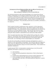
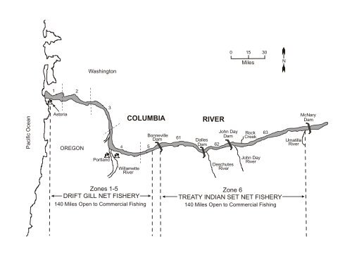
Management <strong>and</strong> Catch Reporting Areas For Lower River Commercial <strong>Fish</strong>eries:<br />
Zone 1 is easterly <strong>of</strong> a line projected from the knuckle <strong>of</strong> the south jetty on the <strong>Oregon</strong> bank to the inshore<br />
end <strong>of</strong> the north jetty on the Washington bank, <strong>and</strong> westerly <strong>of</strong> a line projected from a beacon light at<br />
Grays Point on the Washington bank to the flashing 4-second red buoy "44" <strong>of</strong>f the easterly tip <strong>of</strong> Tongue<br />
Point on the <strong>Oregon</strong> bank.<br />
Zone 2 is easterly <strong>of</strong> a line projected from a beacon light at Grays Point on the Washington bank to the<br />
flashing 4-second red buoy "44" <strong>of</strong>f the easterly tip <strong>of</strong> Tongue Point on the <strong>Oregon</strong> bank, <strong>and</strong> westerly <strong>of</strong><br />
a line projected from the 4-second flashing green light "81" on the Washington bank to a boundary marker<br />
on the easterly end <strong>of</strong> the Beaver Terminal Pier in <strong>Oregon</strong>, including all waters <strong>of</strong> Grays Bay, those<br />
waters <strong>of</strong> Deep River downstream <strong>of</strong> the Highway 4 Bridge, all waters <strong>of</strong> Seal Slough, those waters <strong>of</strong><br />
Grays River downstream <strong>of</strong> a line projected between fishing boundary markers on both banks at the Leo<br />
Reisticka farm, <strong>and</strong> those waters <strong>of</strong> Elokomin Slough <strong>and</strong> Elokomin River downstream <strong>of</strong> the Highway 4<br />
Bridge.<br />
Zone 3 is easterly <strong>of</strong> a line projected from the 4-second flashing green light "81" on the Washington bank<br />
to a boundary marker on the easterly end <strong>of</strong> the Beaver Terminal Pier in <strong>Oregon</strong>, <strong>and</strong> westerly <strong>of</strong> a line<br />
projected true west from the east or upstream bank <strong>of</strong> the Lewis River mouth in Washington.<br />
Zone 4 is easterly <strong>of</strong> a line projected true west from the east or upstream bank <strong>of</strong> the Lewis River in<br />
Washington, <strong>and</strong> westerly <strong>of</strong> a line projected true north from Rooster Rock on the <strong>Oregon</strong> bank, <strong>and</strong><br />
those waters <strong>of</strong> Camas Slough downstream <strong>of</strong> the western most powerline crossing at the James River<br />
Mill.<br />
Zone 5 is easterly <strong>of</strong> a line projected true north from Rooster Rock on the <strong>Oregon</strong> bank, <strong>and</strong> westerly <strong>of</strong> a<br />
line projected from a deadline marker on the <strong>Oregon</strong> bank (approximately four miles downstream from<br />
Bonneville Dam Powerhouse 1) in a straight line through the western tip <strong>of</strong> Pierce Isl<strong>and</strong>, to a deadline<br />
marker on the Washington bank at Beacon Rock.<br />
Area 2S is from a downstream boundary <strong>of</strong> a true north/south line through flashing red 4-second light "50"<br />
near the <strong>Oregon</strong> bank to an upstream boundary <strong>of</strong> a straight line from a deadline marker on the <strong>Oregon</strong><br />
bank (approximately four miles downstream from Bonneville Dam Powerhouse 1) through the western tip<br />
<strong>of</strong> Pierce Isl<strong>and</strong>, to a deadline marker on the Washington bank at Beacon Rock.<br />
Closed Areas:<br />
(1) Unless otherwise specified, the following waters <strong>of</strong> the Columbia River including all <strong>Oregon</strong> Columbia<br />
River tributaries are closed to the taking <strong>of</strong> fish for commercial purposes:<br />
(2) The Columbia River from the ends <strong>of</strong> the jetties to a line projected from the knuckle <strong>of</strong> the south jetty<br />
on the <strong>Oregon</strong> bank to the inshore end <strong>of</strong> the north jetty on the Washington bank.<br />
(3) An area at Grays Bay northerly <strong>of</strong> a line projected from the flashing green 4-second light at Rocky<br />
Point easterly to Harrington Point.<br />
(4) In September an area at the mouth <strong>of</strong> Big Creek from the <strong>Oregon</strong> bank across Knappa Slough to<br />
Karlson Isl<strong>and</strong> which is about one-quarter <strong>of</strong> a mile above the east bank <strong>of</strong> Big Creek, downstream to the<br />
east end <strong>of</strong> Minaker Isl<strong>and</strong> which is about three-quarters <strong>of</strong> a mile below the west bank at the mouth <strong>of</strong><br />
Big Creek.<br />
(5) The Columbia River within an area at the mouth <strong>of</strong> the S<strong>and</strong>y River which is one-quarter mile in width<br />
extending out into the Columbia River from the <strong>Oregon</strong> bank at a right angle to the thread <strong>of</strong> the river<br />
between a point one mile below <strong>and</strong> a point at the upper easterly bank at the mouth <strong>of</strong> the S<strong>and</strong>y River. 2<br />
- Div. 042 8-7-09 <strong>Oregon</strong> Administrative Rules <strong>Oregon</strong> <strong>Department</strong> <strong>of</strong> <strong>Fish</strong> <strong>and</strong> <strong>Wildlife</strong>
(6) An area near Elokomin Slough <strong>and</strong> Steamboat Slough to be described in-season as "Elokomin-A<br />
sanctuary" or "Elokomin-B sanctuary."<br />
(a) "Elokomin-A sanctuary" means those waters <strong>of</strong> Elokomin Slough <strong>and</strong> the Columbia River lying<br />
northerly <strong>and</strong> easterly <strong>of</strong> a straight line from light "37" on the Washington shore to light "39" on Hunting<br />
Isl<strong>and</strong>.<br />
(b) "Elokomin-B sanctuary" means those waters <strong>of</strong> Elokomin Slough, Steamboat Slough <strong>and</strong> the<br />
Columbia River lying inside, northerly <strong>and</strong> easterly <strong>of</strong> a straight line from light "35" (group flashing green)<br />
located on Price Isl<strong>and</strong> to light "39" (flashing green) on Hunting Isl<strong>and</strong> <strong>and</strong> northerly <strong>and</strong> easterly <strong>of</strong> a line<br />
between flashing light "33" on Price Isl<strong>and</strong> <strong>and</strong> quick flashing green light "31" on the Washington shore.<br />
(7) An area at the mouth <strong>of</strong> Abernathy Creek extending out into the Columbia River from the Washington<br />
bank at a right angle to the thread <strong>of</strong> the Columbia River to midstream <strong>of</strong> the ship channel between points<br />
one-half mile above the upper easterly bank at the mouth <strong>of</strong> Abernathy Creek <strong>and</strong> 1,300 yards below<br />
Abernathy Creek at the 4-second flashing green light "81."<br />
(8) The Columbia River <strong>and</strong> Carrolls Channel lying inside the center <strong>of</strong> the shipping channel between a<br />
fishing boundary marker at the junction <strong>of</strong> the Port <strong>of</strong> Longview docks <strong>and</strong> international paper docks on<br />
the Washington shore approximately one mile downstream from the Cowlitz River mouth <strong>and</strong> flashing<br />
green light "29A" on Cottonwood Isl<strong>and</strong> <strong>and</strong> also those waters <strong>of</strong> Carrolls Channel downstream <strong>of</strong> a line<br />
between a fishing boundary marker approximately 3,000 feet upstream <strong>of</strong> the Cowlitz River mouth <strong>and</strong> a<br />
fishing boundary marker on Cottonwood Isl<strong>and</strong>.<br />
(9) An area at the mouth <strong>of</strong> the Kalama River to be described in-season as "Kalama-A sanctuary" or<br />
"Kalama-B sanctuary:"<br />
(a) "Kalama-A sanctuary" means those waters <strong>of</strong> the Columbia River between a fishing boundary marker<br />
on the Washington shore approximately one mile downstream <strong>and</strong> a point one-half mile upstream <strong>of</strong> the<br />
mouth <strong>of</strong> the Kalama River <strong>and</strong> lying within one-quarter mile <strong>of</strong> the Washington shore;<br />
(b) "Kalama-B sanctuary" means those waters <strong>of</strong> the Columbia River between a fishing boundary marker<br />
on the Washington shore approximately one mile downstream <strong>and</strong> a point one-half mile upstream <strong>of</strong> the<br />
mouth <strong>of</strong> the Kalama River <strong>and</strong> extending completely across the Columbia River, excepting those waters<br />
west <strong>of</strong> a line projected from C<strong>of</strong>fin Rock Light "42" in <strong>Oregon</strong> to the Kalama Range Light "47A" on the<br />
Washington shore.<br />
(10) An area at the mouth <strong>of</strong> the Lewis River to be described in-season as "Lewis-A sanctuary" or "Lewis-<br />
B sanctuary:"<br />
(a) "Lewis-A sanctuary" means those waters <strong>of</strong> the Columbia River between a point one mile downstream<br />
<strong>and</strong> a point one-half mile upstream <strong>of</strong> the mouth <strong>of</strong> the Lewis River <strong>and</strong> lying within one-quarter mile <strong>of</strong><br />
the Washington shore;<br />
(b) "Lewis-B sanctuary" means those waters <strong>of</strong> the Columbia River near the mouth <strong>of</strong> the Lewis River<br />
lying easterly <strong>of</strong> lines projected from light "79" (flashing green) to the Red Buoy No. 4 thence to a fishing<br />
boundary marker on Bachelor Isl<strong>and</strong>.<br />
(11) The Columbia River <strong>and</strong> Camas Slough north <strong>of</strong> Lady Isl<strong>and</strong> within the area enclosed by a line from<br />
the Washington bank due south to the west end <strong>of</strong> Lady Isl<strong>and</strong>, upstream along the shoreline <strong>of</strong> Lady<br />
Isl<strong>and</strong> to the highway bridge at the east end <strong>of</strong> Lady Isl<strong>and</strong>, across such bridge to the Washington bank.<br />
(12) The Columbia River upstream <strong>of</strong> a line projected from a deadline marker on the <strong>Oregon</strong> bank to a<br />
deadline marker on the Washington bank, both such deadline markers located approximately five miles<br />
downstream from Bonneville Dam.