Moravské vinaÅské stezky Places at former Iron ... - Iron Curtain Trail
Moravské vinaÅské stezky Places at former Iron ... - Iron Curtain Trail
Moravské vinaÅské stezky Places at former Iron ... - Iron Curtain Trail
- No tags were found...

You also want an ePaper? Increase the reach of your titles
YUMPU automatically turns print PDFs into web optimized ePapers that Google loves.
EuroVelo 13 /The <strong>Iron</strong> <strong>Curtain</strong><strong>Trail</strong> in SouthMoravia and LowerAustria
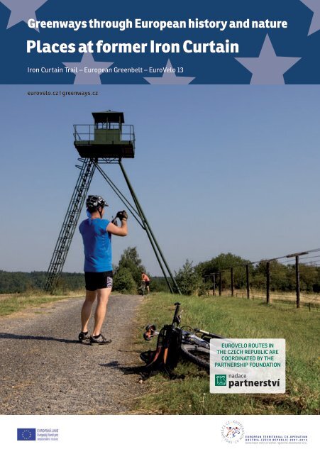
<strong>Places</strong> <strong>at</strong> <strong>former</strong> <strong>Iron</strong> <strong>Curtain</strong>3n Remnants of the military road, guard towers, and tank traps in South Moravia.The <strong>Iron</strong> <strong>Curtain</strong> comes downOn the borders of Czechoslovakia the situ<strong>at</strong>ionbecame tense after the events of February 1948,when the Communist Party of Czechoslovakia cameto power. Two days earlier, on 23 February 1948,the already-communist-controlled Ministry of theInterior revoked all passports, and began requiringexit papers for all those travelling abroad. InOctober of th<strong>at</strong> year a law was adopted th<strong>at</strong> definedunauthorized crossing of the country’s bordersas a criminal act. One year l<strong>at</strong>er the communistdict<strong>at</strong>orship took away its citizens’ right to acquiretravel documents. Even so, by 1951 accordingto official numbers nearly 12,000 people hademigr<strong>at</strong>ed from Czechoslovakia (the true numberswere probably much higher). Many people of thispost-1948 wave of emigr<strong>at</strong>ion left their homelandunder thre<strong>at</strong> of political persecution, imprisonment,expulsion from school, or loss of employment, lossof property during the process of n<strong>at</strong>ionaliz<strong>at</strong>ion,etc. Most of them chose to escape into Bavaria viaforested Šumava Mountains, which until 1951 wasweakly guarded. Even so, knowledge of the localterrain – and a healthy dose of luck – was necessaryto get across. This was provided by the smugglers,who undertook the activity either from conviction,or for money. Another way to get to the West wasover the border with Austria. At first this choice wasnot ideal, because until 1955 the part of Austriaadjacent to Czechoslovakia was part of the Sovietzone of occup<strong>at</strong>ion. Refugees here risked detentionby the Soviets and return to Czechoslovakia.A mass exodus of Czechoslovak citizens was tobe prevented by hermetically sealing a 750 kmstretch of the country’s border with Germany andAustria. The decision was taken in 1951 to cre<strong>at</strong>e aset of physical barriers, and establish a new borderguard corps built on the Soviet model. Thus a real<strong>Iron</strong> <strong>Curtain</strong> began to take form. It was manned byseveral brigades of border guard soldiers. Some16,000 guards were deployed in all, and furnishedwith all the powers of the military and securityforces. Most were recruited from the ranks ofpolitically reliable citizens – draftees and careersoldiers. Over the course of time the corps wouldtake on gradu<strong>at</strong>es from the Border Guard MilitaryAcademy in Prague, founded for this purpose in1951. Officials <strong>at</strong> the highest levels studied <strong>at</strong> Sovietschools and underwent training by the Soviet secretservice, the KGB.
making the footprints of those fleeing clearlyvisible. Along the entire length of the fence, woodenand l<strong>at</strong>er metal guard towers sprung up th<strong>at</strong> madeit easy to monitor each segment. At night the borderzone could be lit up by powerful spotlights and tripwireillumin<strong>at</strong>ion flares.Border guards were also assisted by service dogs,whose keen sense of smell helped them quicklytrack down and detain escapees. The independent<strong>at</strong>tack dogs served as a kind of substitute forelectric fences. In some of the more difficult-toaccesssegments, where the fence was very nearthe actual border, they were placed in pens whichautom<strong>at</strong>ically opened when the signal wall wastripped. The dogs served as advance guard untilthe border p<strong>at</strong>rols could reach the site. However,the use of independent dogs proved to be just asinhumane as the electrified fences, as seen in thecase of nineteen-year-old East German HartmutTautz. In the summer of 1986 he tried to get acrossthe <strong>Iron</strong> <strong>Curtain</strong> near Br<strong>at</strong>islava, when he wasstopped by independent <strong>at</strong>tack dogs just 20 m shortof the border. He died of severe wounds in hospitalsome hours l<strong>at</strong>er.There were far fewer official border crossings forautomobile traffic between Czechoslovakia and<strong>Places</strong> <strong>at</strong> <strong>former</strong> <strong>Iron</strong> <strong>Curtain</strong> 5West Germany and Austria than there are today.And they were closely guarded – for example, withheavy g<strong>at</strong>es th<strong>at</strong> could not be broken by a movingvehicle. Historically less-important roads leadingto the west were closed permanently, for exampleby digging up the road. On the w<strong>at</strong>ercourses th<strong>at</strong>crossed the st<strong>at</strong>e border, underw<strong>at</strong>er gr<strong>at</strong>es andobserv<strong>at</strong>ion pl<strong>at</strong>forms were set up to preventescape to the West under w<strong>at</strong>er. Larger rivers likethe Danube were monitored by motorbo<strong>at</strong> p<strong>at</strong>rols.Trains crossing the border were subject to thoroughsearches, even freight trains where people couldhide in coal wagons, for example.Victims of the <strong>Iron</strong> <strong>Curtain</strong>Despite all the pitfalls and security measures, therewere people who were determined to risk theirlives, or <strong>at</strong> best long prison sentences, to get overthe border. Their yearning for freedom, democracy,and a chance to pursue one’s goals was so strong(and their chances of legally travelling to the Westso negligible) th<strong>at</strong> their conscience gave them noother choice.We will probably never know the exact number ofthose who from 1951 to 1989 made it across the <strong>Iron</strong><strong>Curtain</strong> from our country. The constant perfectingn In the past only the border guards could enjoy this beautiful view from behind the <strong>Iron</strong> <strong>Curtain</strong> intoAustria over the River Dyje (picture taken from the bridge to Hardegg).
6 Greenways through European history and n<strong>at</strong>ureof 1968. Thousands of people th<strong>at</strong> summer decidednot to come back from vac<strong>at</strong>ion in the Westerncountries or Yugoslavia. Tens of thousands of othersleft the CSSR soon after August 1968 while it was stillpossible. From the spring of 1968 until October 8,1969 the borders with the FRG and Austria remainedrel<strong>at</strong>ively open, until the new government, now ledby the pro-Soviet Husák, finally was able to put anend to the changes introduced by the pro-reformDubček government. The year and a half when it waspossible to travel freely was totally unique in thehistory of the communist regime in Czechoslovakia.Never before or after was it so easy to get out ofsocialist Czechoslovakia.By the l<strong>at</strong>e 1970s and 1980s, after the deepest partof the so-called normaliz<strong>at</strong>ion, some possibilitiesopened up for travel to the West or <strong>at</strong> least to thesocialist (but independent of the Soviet Union)Yugoslavia. It was still very difficult, but theCzechoslovak “jail” opened up a few cracks, andfrom 1979 on some 5,000 people a year successfullyemigr<strong>at</strong>ed.of the barrier made it harder and harder to do, andso probably only a few dozen people a year wereable to make it. We have a better idea of the sadnumber of victims: some 350 civilians (of whom200 were shot) and 648 border guards, of which208 committed suicide and 67 were shot by theircolleagues (deliber<strong>at</strong>ely while trying to escape overthe border; or accidently).Getting overFrom 1948 to 1989 several hundred thousandpeople emigr<strong>at</strong>ed from Czechoslovakia to the West.Official numbers speak of 200 thousand; the highestestim<strong>at</strong>es are a half million. We have already talkedabout the period before the <strong>Iron</strong> <strong>Curtain</strong> went up(1948-1951). But wh<strong>at</strong> came afterward?The largest wave of emigrants (<strong>at</strong> least 65 thousand)took advantage of the temporary hesit<strong>at</strong>ion of theregime and left the country in 1968–1969 after theinvasion of Czechoslovakia by the armies of theWarsaw Pact on August 21, 1968. It put a sudden endto the democr<strong>at</strong>iz<strong>at</strong>ion, liberal reforms, and politicalrelax<strong>at</strong>ion (a.k.a. “socialism with a human face”)begun by Dubček’s government: the Prague SpringSome people, for example, failed to return fromwork-rel<strong>at</strong>ed abroad where they were sent by theiremployer. This decision was not easy, however,as it meant separ<strong>at</strong>ion from family, who couldbe persecuted by the regime. Especially in the1980s it was easy for most people, even for wholefamilies, to get permission to travel to Yugoslavia,a “fr<strong>at</strong>ernal socialist country”, and the promisedland for summer holidays. This was a good chancefor people who wanted to emigr<strong>at</strong>e to the West.There was no <strong>Iron</strong> <strong>Curtain</strong> between Yugoslavia andneighboring Italy and Austria, so one could get tothe west over an unguarded border (usually in themountains), or often even by the regular bordercrossing, if the border guard was sufficientlybenevolent. And last but not least there were thosewho set out to visit Cuba with a layover in someforeign city, perhaps Montreal, where one had toget off the plane while it was being refueled. In theairport terminal they would ask for asylum.Most emigrants did not have a pre-arranged placein a foreign country; they left their homeland withempty hands, and often had to sit out months ina refugee camp. Here they had to wait for theirdocuments to be issued th<strong>at</strong> would allow themto gain asylum. The risk, the uncertainty, and theawareness th<strong>at</strong> they would have to start again <strong>at</strong> the
ottom, was understood as the price of the freedomfor which they longed.In the l<strong>at</strong>e 1970s and early 1980s there were thosewhose emigr<strong>at</strong>ion was forced, who found theirdeparture for the west suddenly hastened bythe authorities. Forced exile meant permanentdeport<strong>at</strong>ion from Czechoslovakia; most of the onesexiled in this way were sign<strong>at</strong>ures of Charter 77 (adocument and a civic initi<strong>at</strong>ive th<strong>at</strong> criticized theCzechoslovak communist regime for suppressingthe human and civil rights th<strong>at</strong> the CSSR hadagreed to in 1975 under intern<strong>at</strong>ional agreement).The government found these people extremelyinconvenient, even dangerous. Under oper<strong>at</strong>ionAsanace (Sanit<strong>at</strong>ion), the goal of which was toisol<strong>at</strong>e Charter 77’s main organizers, the St<strong>at</strong>eSecurity (StB) subjected a number of dissidentsto harassment, blackmail, and thre<strong>at</strong>s ofimprisonment to force them to leave the country.Wh<strong>at</strong> did one have to do during the era of so-called“real socialism” in Czechoslovakia to be allowed tolegally leave the country?From today’s perspective the conditions <strong>at</strong>tachedto leaving the country might seem like a bad joke.It was not enough to have a valid passport or visa(necessary for all the West European countries).Much more was needed, including a gre<strong>at</strong> deal ofp<strong>at</strong>ience and a strong stomach, because the entire<strong>Places</strong> <strong>at</strong> <strong>former</strong> <strong>Iron</strong> <strong>Curtain</strong> 7incredibly long bureaucr<strong>at</strong>ic process was extremelydegrading. Around the end of the 1970s it becameeasier to travel to the West or Yugoslavia, but therewere still an inordin<strong>at</strong>e number of barriers. One’schances of getting permission decreased if a personwas “politically unreliable”, or the more membersof a family wished to travel <strong>at</strong> once.After requesting a certific<strong>at</strong>e of a clean criminalrecord, which usually took several weeks toobtain, it was necessary to get a permit to leavethe country. It clearly st<strong>at</strong>ed the number of days aperson was allowed to spend abroad, and a preciselist of the countries he could visit. After 1970 it waspossible to get a permanent exit visa to the EastEuropean countries, so it was not necessary to gothrough the complic<strong>at</strong>ed process every time. It wasmuch more difficult to get permission to travel toWestern Europe. This process could take months,but success was not guaranteed. It was grantedonly on the recommend<strong>at</strong>ion of a whole seriesof various person and organs, for example one’semployer or school, the ROH (Revolutionary LaborMovement), military officials, municipal officials,the Communist Party’s street committees, and soon. Often an interview with the cadre department <strong>at</strong>one’s workplace was required. Your f<strong>at</strong>e was in thehands of people you didn’t know.The granting of permission to leave was not the endof the ordeal. Travelling to the democr<strong>at</strong>ic foreignn Remnants of the<strong>Iron</strong> <strong>Curtain</strong> nearČížov
8 Greenways through European history and n<strong>at</strong>ureworld and socialist Yugoslavia also depended onobtaining a foreign currency allotment. Outsideof the black market it was the only way onecould legally exchange Czechoslovak crownsfor foreign currency. The Czechoslovak st<strong>at</strong>ebank again granted these on the basis of variousrecommend<strong>at</strong>ions and political reliability. Onlylimited amounts of money could be exchanged,and each year it could only be done until the endof March. The only thing th<strong>at</strong> could save youfrom having to have the currency allotment was anotarized, open invit<strong>at</strong>ion to visit a country (from afamily member, for example, or another emigrant).More weeks were spent applying for the appropri<strong>at</strong>evisa or visas. If the bank allowed the transaction,after filling out customs and currency st<strong>at</strong>ementsand paying for the special stamp, the currencycould be exchanged. University gradu<strong>at</strong>es wererequired to leave their university degree with theiremployer for the time of their absence.Underw<strong>at</strong>er to freedomMany people’s efforts to fulfill the requirements forlegal travel to the Western countries were in vain,and permission to travel was denied. The mindsof many people who wanted to emigr<strong>at</strong>e began tofocus on an illegal crossing of st<strong>at</strong>e borders.“Let the evil jaws of the warmongers turn to stone/ hold your weapon firmly / aim your shot straightand true / firmly defend the people and yourhomeland!”Poem For Peace, 1951Now let us tell some of the fascin<strong>at</strong>ing stories ofpeople who succeeded in their courageous plansfor fleeing across the border. Although no one triedto shoot their way to freedom like the membersof the Masin Brothers group in the 1950s, in mostcases it was still a real drama, decided by minutesor seconds, and reliant on major doses of luck, andoften on precise and long-term prepar<strong>at</strong>ion, studyof the area and use of skills, inventiveness, goodtactics, good timing, and quick legs. Unfortun<strong>at</strong>ely,the longed-for freedom was not always waiting <strong>at</strong>the end – unsuccessful <strong>at</strong>tempts resulted in manyyears’ imprisonment.“We didn’t want to shoot. But we got into situ<strong>at</strong>ionswhere we had to shoot. It was either us or them. Theregime declared class war. Not us. They killed andexecuted. We were supposed to face them with ourbare hands?"Milan Paumer, memberof the Masin Brothers armed groupThe “classic way” over the border, on one’s own twolegs, chose Václav Bařina, Miloš Ostrčilík, and twoother young people, on 20 September 1985, whenthey dug, cut, and crawled under the wire near thevillage of Úvaly, near Valtice on the border withn „Freedom tank"
n Museum of theCzech BorderFortific<strong>at</strong>ions in Š<strong>at</strong>ov<strong>Places</strong> <strong>at</strong> <strong>former</strong> <strong>Iron</strong> <strong>Curtain</strong>11The <strong>Iron</strong> <strong>Curtain</strong> is torn downOn December 4, 1989, in the euphoria of theVelvet Revolution, the border with the West wasopened, and th<strong>at</strong> same month the barbed wiresepar<strong>at</strong>ing the CSSR from Austria between H<strong>at</strong>ěand Kleinhaugsdorf was ceremonially removed bythe first post-1989 foreign minister Jiří Dienstbierand his Austrian colleague Alois Mock. Less thana week l<strong>at</strong>er there was a ceremonial cutting of thewires <strong>at</strong> the town of Nové Domky u Rozvadova onthe Czech-Bavarian border. By mid-1990 almost allthe barbed-wire fences on the Czechoslovak borderwere been removed, and only a few remnants of the<strong>Iron</strong> <strong>Curtain</strong> were left.For over 20 years the ravages of time have beene<strong>at</strong>ing away <strong>at</strong> wh<strong>at</strong>’s left of the <strong>Iron</strong> <strong>Curtain</strong>. In thefields and meadows you would have a hard timefinding the evidence, and some of the scars left inthe Czech and Moravian forests are quickly healing,too. If it weren’t for the <strong>former</strong> signal roads th<strong>at</strong>lead along the border, which are used today byhikers and cyclists; and if it weren’t for the Moravianvintners who saved some of the guard towers tow<strong>at</strong>ch over their vineyards, we might have a hardtime finding where the <strong>Iron</strong> <strong>Curtain</strong> was.In the region of South Moravia we can find a rareremnant of the <strong>Iron</strong> <strong>Curtain</strong> outside the town of Čižovin the Podyjí N<strong>at</strong>ional Park, where there is now asimple <strong>Iron</strong> <strong>Curtain</strong> Memorial. It consists of a singlewall of barbed wire about 300 m long, the signalroad, and one guard tower. An inform<strong>at</strong>ion paneltells you about the history of the <strong>Iron</strong> <strong>Curtain</strong>, andby prior arrangement the personnel from the nearbypark visitor center can tell you about it as well.Another important relic of the <strong>Iron</strong> <strong>Curtain</strong> is foundin the Dyje triangle south of Břeclav, along almostthe entire western border of the Soutok gamereserve. All but forgotten stands a wall of barbedwire a couple of kilometers long, which todayserves as a barrier to animals. For this purposethe fence lost its upper wires th<strong>at</strong> reached out tothe sides, and has been given regular chain linksections and sometimes wooden planks. Cyclistsand walkers passing by do not even realize th<strong>at</strong> theyare walking along the actual wires th<strong>at</strong> were longpart of a physical barrier thousands of kilometerslong between the East and the West. Climbingplants, grasses, and sediment from the occasionalfloods are beginning to swallow some of the fence,but the original g<strong>at</strong>es in the fence th<strong>at</strong> occur every100-200 meters and which the border guards usedin their pursuit of escapees and movement betweenthe layers of wire, betray the fact th<strong>at</strong> this is noordinary fence.In the village of Š<strong>at</strong>ov we find the Museum of theCzechoslovak Fortific<strong>at</strong>ions d<strong>at</strong>ing from 1935–1938, which has a new section devoted to the <strong>Iron</strong><strong>Curtain</strong>, fe<strong>at</strong>uring a guard tower, several fields ofwire barriers, and a field of the kind of anti-tankbarriers known as “Czech hedgehogs”. The original<strong>Iron</strong> <strong>Curtain</strong> line of barbed wire went through here
12 Greenways through European history and n<strong>at</strong>uren Museum of the <strong>Iron</strong> <strong>Curtain</strong> in Valticea few meters south of the signal road. The area isdomin<strong>at</strong>ed by the pre-WWII-era bunker surroundedby metal hedgehogs, which is open to the public inthe summer.The Museum of the <strong>Iron</strong> <strong>Curtain</strong> opened in 2011the <strong>former</strong> border guard barracks above Valtice. Ahalf-hour tour tells visitors about the <strong>Iron</strong> <strong>Curtain</strong>’stechnical aspects and means, the border guards’equipment, and period documents. The exhibitincludes a real detention cell, and a demonstr<strong>at</strong>ionmodel of the wire barriers.A 13th panel is loc<strong>at</strong>ed <strong>at</strong> the Mikulov castle alongwith a bell of freedom. Here the <strong>Trail</strong> of Freedomstarts for walkers and cyclists which links all thepanels. It was opened in 2011 by the civic associ<strong>at</strong>ionPaměť with the <strong>at</strong>tendance of several successfulescapees.The stories of those who successfully andunsuccessfully tried to cross the <strong>Iron</strong> <strong>Curtain</strong> aretold on 12 panels in Czech and German along 2 kmof <strong>former</strong> signal road southeast of Mikulov.n Remnants of thebarbed wire in theSoutok reserve
<strong>Places</strong> <strong>at</strong> <strong>former</strong> <strong>Iron</strong> <strong>Curtain</strong>13The European Green BeltBorders divide, n<strong>at</strong>ure unitesThe <strong>Iron</strong> <strong>Curtain</strong> was a long belt of “no-man’s land”between the East and West, which was up to severalkilometers wide in some places. Entering this areawithout a special permit was strictly forbidden; economicactivity was severely limited. Paradoxicallythis cre<strong>at</strong>ed a unique “green belt” the whole wayacross Europe th<strong>at</strong> was spared many of the neg<strong>at</strong>iveimpacts of human activity, such as massive pollutionor loss of biodiversity. It’s no accident, then,th<strong>at</strong> shortly after the fall of the <strong>Iron</strong> <strong>Curtain</strong> and thesubsequent opening up of this land to the public,the most valuable n<strong>at</strong>ural localities were declaredprotected areas by the various countries, in the formof n<strong>at</strong>ional or n<strong>at</strong>ural parks, biosphere reserves, orprotected areas under the program N<strong>at</strong>ura 2000.Although the territory we are talking about is mainlythe forbidden border zones of the east-bloc countries,the n<strong>at</strong>ural environment in the adjacent areaalong the other, western side of the border profitedas well from the decline in human activity. This, too,was part of the reason th<strong>at</strong> protection of this greenbelt eventually turned into a European-wide initi<strong>at</strong>ivewhich grew out of the original idea for a greenbelt between East and West Germany th<strong>at</strong> wassigned by more than 400 n<strong>at</strong>ure protectionists <strong>at</strong> ameeting in the Bavarian town of Hof, near the EastGerman border. Here’s where the name Green Beltwas first introduced.At present dozens of organiz<strong>at</strong>ions and groups interestedin protecting the European Green Belt are beingdirected by a European coordin<strong>at</strong>ing group; theCzech represent<strong>at</strong>ive is the Partnership Found<strong>at</strong>ion.The European Green Belt, nearly 12,500 km long,passes through 24 European countries; in 2003 <strong>former</strong>Soviet president Michail Gorbachev became itsp<strong>at</strong>ron. Although it cannot be said th<strong>at</strong> the green beltrepresents a completely contiguous chain of originalecosystems, we can imagine it as a necklace th<strong>at</strong> connectson a European scale unique concentr<strong>at</strong>ions ofn<strong>at</strong>ural jewels and other valuable n<strong>at</strong>ural localitiesrich in flora and fauna, including many endangeredspecies. For these the possibility of safer migr<strong>at</strong>ionbetween individual regions and countries can beLŰBECKOSLOSTOCKHOLMBERLÍNPRAHAVÍDEŇHELSINKYGDAŇSKVARŠAVABRATISLAVABUDAPEŠŤBĚLEHRADRIGASOFIEPETROHRADBUKUREŠŤdecisive, while intensive economic activity and constructionis a thre<strong>at</strong> to them. At a time of reopenedborders and the development of economically-underdevelopedborder areas (especially on the eastbloc side), it is very important to be aware of this andprevent the fragment<strong>at</strong>ion of biotops.Interest in the n<strong>at</strong>ural wealth of the green belt doesnot have to conflict with economic development inthe border regions. On the contrary, whether it bedevelopment of the tourist industry, agriculture, orindustry, the principle of sustainability must be observed;th<strong>at</strong> is, the low-impact integr<strong>at</strong>ion of humanactivity into a given environment.The Green Belt in South MoraviaUnlike the largely forested and mountainous areasof the green belt in Bohemia, its South Moraviansegment continues through to much lower elev<strong>at</strong>ions.The cultured landscape here is more agriculturalthan forestry-based, with the fields, meadows,and vineyards for which South Moravia is so wellknown.
14 Greenways through European history and n<strong>at</strong>uren Bodies of w<strong>at</strong>er playan important rolein the green belt ofSouth MoraviaThe gre<strong>at</strong>est jewels of the South Moravian GreenBelt are the Podyjí N<strong>at</strong>ional Park and the DolníMorava Biosphere Reserve, which includes thePálava Hills Protected Landscape Area, the Lednice-ValticeArea, and the region of floodplainforests south of Břeclav to the confluence of theDyje (Thaya) and Morava (March) Rivers. It is remarkableth<strong>at</strong> besides the border with Austria, orthe <strong>former</strong> <strong>Iron</strong> <strong>Curtain</strong>, the entire territory of theSouth Moravian green belt unites the Dyje Riverflowing through the countryside from west toeast. The Dyje thus forms the second backbone ofthe green belt of South Moravia, which in severalplaces also corresponds to the first, the country’sborder with Austria. The hiking trails of the SouthMoravian green belt, which we will talk about l<strong>at</strong>er,are almost exclusively concentr<strong>at</strong>ed in the PodyjíN<strong>at</strong>ional Park and the Dolní Morava Biosphere Reserve.The marked tourist trails referred to in thetext can be found in the map segments <strong>at</strong> the endof this brochure.Podyjí N<strong>at</strong>ional Park and Thay<strong>at</strong>alThe Podyjí N<strong>at</strong>ional Park was formed out of the<strong>former</strong> protected landscape area as of July 1, 1991.It protects the 40-km-long and up to 220-meterdeepDyje River canyon between Vranov nad Dyjíand Znojmo. Covering an area of only 63 km² (and29 km² of protected buffer zone) it is the country’ssmallest n<strong>at</strong>ional park; but the range of its n<strong>at</strong>uralwealth is comparable to some of the largest protectedareas. The area merits its highest of c<strong>at</strong>egoryn<strong>at</strong>ure protection not only for the deep river valley,one of the most unspoiled in the CR, but also thehe<strong>at</strong>h and steppe habit<strong>at</strong> on its Eastern edge. In thePodyjí we find plants and animal species typical forthe cooler Hereynicum areas of Central Europe, withrepresent<strong>at</strong>ives of warmer Pannonian from the <strong>former</strong>Yugoslavia and Hungary. This is reflected in thelarge popul<strong>at</strong>ions and variety of flora and fauna inthe Podyjí N<strong>at</strong>ional Park.There are more than 1,300 species of higher plants,of which several dozen are specially protected (forexample Alpine Cyclamen, Showy Mullein, Gre<strong>at</strong>erPasque Flower, Dwarf Iris, Black False Hellbore,and 18 types of orchid). In the western part are submontanebeechwood with fir and yew, which towardthe east turn into stands of oak-hornbeam wood.Among the rarer species are Cornelian Cherry, CommonJuniper, Common Cotoneaster, and wild cherry.In localities subject to temper<strong>at</strong>ure inversion we findSycamore Maples, European Bladdernut, and alpinerose.Of the animal kingdom, 65 species of mammal maketheir home in Podyjí N<strong>at</strong>ional Park (including theBicolored Shrew, Field Vole, Brandt’s B<strong>at</strong>, and EuropeanOtter), 152 species of birds, of which two thirdsnest here (for example the Black stork – symbol ofthe Podyjí NP, Hoopoe, Kingfisher, Honey Buzzard,and Eurasian Eagle-owl), seven species of reptile(including European Green Lizard, and Aesculapiansnake), fourteen species of amphibian (Gre<strong>at</strong>Crested Newt, Fire Salamander, and several typesof frog), and a large number of insects, such as thePraying Mantis, Rhinoceros Beetle, Owlfly, Mantispid,Stag Beetle, Gre<strong>at</strong> Capricorn Beetle, and twelvespecially-protected species of butterfly.
The fish popul<strong>at</strong>ion on the Dyje River in the n<strong>at</strong>ionalpark was neg<strong>at</strong>ively affected by the construction ofthe Vranov Dam in the 1930s. Since then the currentof the Dyje River downstream from the dam hasbeen colder. The current is different too, adjusted tothe needs of the electric power st<strong>at</strong>ion on the daminstead of the needs of the fish. The number of specieshas declined and the river has changed from abarbell zone to a trout zone, and it also prevents fishfrom migr<strong>at</strong>ing upstream. In 1965 the Znojmo damwas built, preventing fish from migr<strong>at</strong>ing downstreamas well.Even so the environment in Podyjí is of rare quality,paradoxically thanks to the <strong>former</strong> <strong>Iron</strong> <strong>Curtain</strong>,when most of this area lay within the forbiddenborder zone. Except for the forest cuts for the borderfences, which are almost overgrown today (butcan still be seen from the Železné schody lookout),n<strong>at</strong>ure in Podyjí has been left to n<strong>at</strong>ural processeswithout major human influence.Another gre<strong>at</strong> benefit for the Podyjí has been thecre<strong>at</strong>ion of the Thay<strong>at</strong>al N<strong>at</strong>ional Park (13.3 km²) onthe Austrian side of the river as of January 1, 2000.This cre<strong>at</strong>ed a bil<strong>at</strong>eral protected n<strong>at</strong>ional park Podyjí– Thay<strong>at</strong>al, which has produced even benefitsfor n<strong>at</strong>ure (for example in the form of joint projectsby environmentalists from the two countries), exchangeof d<strong>at</strong>a and experience, etc.) as well as forvisitors, who can use the interconnected network ofhiking trails and bi-lingual inform<strong>at</strong>ion panels.The Podyjí N<strong>at</strong>ional Park can be discovered on footalong more than 80 km of hiking trails marked withthe Czech Tourist Club’s classic stripes and arrows,and in the Thay<strong>at</strong>al along 25 km of route markedwith colored panels. These easy to moder<strong>at</strong>e trailsare laid out so as to take you to all the points of interestin the area, and introduce you to the characteristicfe<strong>at</strong>ures of this unique area. If you make useof the connections and crossroads between the two,you can walk the whole area from Vranov nad Dyjíin the west to the Havranice he<strong>at</strong>h and the town ofZnojmo in the east.At important sites on both sides, multi-lingual inform<strong>at</strong>iontables are placed to tell you about the n<strong>at</strong>uraland historic points of interest in this area. Youcan also get inform<strong>at</strong>ion <strong>at</strong> the visitor center abovethe town of Hardegg. From spring to fall both parksoffer a number of guided them<strong>at</strong>ic walks and rides.n Dyje River Valleyn Alpine rose<strong>Places</strong> <strong>at</strong> <strong>former</strong> <strong>Iron</strong> <strong>Curtain</strong>15
16 Greenways through European history and n<strong>at</strong>uren Green LizardYou can find the calendar of events <strong>at</strong> (www.nppodyji.cza www.np-thay<strong>at</strong>al.<strong>at</strong>).When touring the park you won’t find crowds oftourists. You’ll have the time and the peace to enjoythe views from the overlooks high above theDyjí River canyon, with its slopes adorned withhealthy forests and numerous rock outcroppingsand scree fields. Don’t miss the rock landing withobelisk above Ledové sluje, and the Smugglers’<strong>Trail</strong> (on the red-marked hiking trail), which leadsto it from the south on the edge of a steep forestedslope on the Moravian side of the border. The DyjeRiver quietly hums <strong>at</strong> the bottom, or rushes loudlyin places where small dams were built to service thew<strong>at</strong>er mills there. All th<strong>at</strong> is left of the mills todayare some old found<strong>at</strong>ions and the meadows wherethey had their barns and outbuildings. Today thesemeadows are valued for their rich variety of wildflowers,which in turn support many insects, includinga gre<strong>at</strong> variety of butterflies. Last but not leastare the marvelous views down into the Dyje canyonfrom the left bank above the Znojmo reservoir <strong>at</strong> theKrálův stolec overlook, and from Sealsfield’s Rockoverlook on the right bank.n Black StorkThe Austrian side of the Dyje River valley is best exploredvia the red-marked hiking trail “Thaytalweg”between Hardegg and the ruined castle Kaja, whichis probably the most beautiful marked trail in theThay<strong>at</strong>al Park. About halfway through you come toa narrow rock form<strong>at</strong>ion where two mighty meandersof the Dyje meet – the Austrian Umlauf and theOstroh in Moravia. Beside the unforgettable sceneryof the deep river valley, there is also a fine view fromhere of the nearby ruined castle of Nový Hrad.On the Moravian side, the river and meadows arebest discovered via the yellow and blue hiking trailfollowing the big meander and the Šobes vineyard.Here you can observe life on the river from twosuspended foot bridges directly over the Dyje. Andwhile you’re in Šobes, don’t forget to visit its famousvineyard, one of the most beautiful in all of Europe,on the north bank of the river facing south. Thegrapevine has been grown here since the MiddleAges, while the locality has been inhabited sincethe Stone Age. Right by the vineyard there is a standwhere during the tourist season you can taste winefrom this vineyard (mainly Pinot Gris and Blanc,Rhine Riesling and Welsch Riesling). The extraordinaryŠobes locality produced wines served <strong>at</strong> thetable of the Czech kings. From the trail junctionPod Šobesem, over the bridge and meadow on themarked trails is a little less than a kilometer.You can admire some other vineyards on the easternedge of both n<strong>at</strong>ional parks above the winemakingtowns of Retzbach, Hnanice, Havraníky, Popice, andKonice, where the rows of vines stretch out towardsthe eastern horizon, and southward into Austria.Distant vistas are offered by a hike along the yellowand red trails, from the pilgrimage site of HeiligerStein to the south, to the town of Znojmo in the
north. Your trail will take you through a large areaof he<strong>at</strong>h (which blooms beautifully purple in the IndianSummer), containing rare thermophilic speciesof plants and insects.In the following list you will find more historicallyand touristically interesting and <strong>at</strong>tractive places<strong>Places</strong> <strong>at</strong> <strong>former</strong> <strong>Iron</strong> <strong>Curtain</strong> 17which you should not miss in your wanderingsthrough Podyjí and Thay<strong>at</strong>al N<strong>at</strong>ional Parks:1) The smallest town in Austria, Hardegg, is setharmonically into the narrow basin of the Fugnitzstream <strong>at</strong> its confluence with the Dyje. It isdomin<strong>at</strong>ed by a castle <strong>at</strong>op the rock, the origins ofn Marked hiking trails in the Podyjí NP and Hardegg overlook.n Rock form<strong>at</strong>ions near ŠobesnSuspension bridge over the Dyje River below Šobes.
18 Greenways through European history and n<strong>at</strong>uren The <strong>former</strong> signal road in theeast part of the Podyjí is linedby vineyards perfect for nordicwalking. The Znovin Znojmowinery’s inform<strong>at</strong>ion panel tellsabout the local wine tradition andlocal points of interest. Don’t resistthe tempt<strong>at</strong>ion to visit one of thewine cellar streets and taste theexcellent wine being offered.which go back to the 10th century. The village isso picturesque th<strong>at</strong> it became a popular summerdestin<strong>at</strong>ion back in the l<strong>at</strong>e 19th century. Th<strong>at</strong> erawas ended by the Second World War, and the periodfrom 1948 to 1989 when the <strong>Iron</strong> <strong>Curtain</strong> madeHardegg the “town <strong>at</strong> the end of the world”, asthe popul<strong>at</strong>ion moved away and the economy declined.Reopening of the border bridge across theDyje in 1990 on the initi<strong>at</strong>ive of the local citizensbrought the slow revival of cross-border tourism.Today Hardegg is the heart of the Thay<strong>at</strong>halN<strong>at</strong>ional Park and the main g<strong>at</strong>eway to the hikingtrails in the area. From the town, its castle, andthe Dyje River valley there are excellent views ofthe nearby rock form<strong>at</strong>ions: Einsiedler, Hennerweg,Maxpl<strong>at</strong>eau, Reginafelsen, and the Hardeggoverlook over on the Moravian side.2) The ruins of the hunting castle Nový Hrádekstand amidst the thick forest of the Podyjí’s centralpart. From its observ<strong>at</strong>ion pl<strong>at</strong>form there is aspectacular view of the Dyje meandering aroundthe Ostroha on the Moravian side and the Umlaufbergon the Austrian side. The relief of the terraingives the impression of three rivers flowingaround the castle.3) The 800-year-old castle ruins of Kaja not farfrom Merkersdorf in Austria stand on a rockycrest surrounded by two streams. From the 23-mhightower there is a beautiful view of the forestin the Thay<strong>at</strong>al N<strong>at</strong>ional Park in the valley of theKajabach stream, and further onward within thePodyjí N<strong>at</strong>ional Park. The castle, which was visitedfrequently from 1252 to 1278 by Czech KingPřemysl Otakar II., fe<strong>at</strong>ures the residential hallof the medieval castle, fountain, armory, knightlyhall, chapel, and dungeon tower.4) Vranov nad Dyjí is commanded by its Baroquepearl of a ch<strong>at</strong>eau, rising high on a cliff abovea bend in the Dyje River. From the ch<strong>at</strong>eau onelooks down <strong>at</strong> the village and neighboring slopes,each with their own favorite overlook points:
Hallamassková overlook, Mniszek Cross, andTanečnice). The Clary Cross overlook gives thebest view of the dam and w<strong>at</strong>er <strong>at</strong> the VranovReservoir, which invites you for a cool refreshingswim in the summertime.<strong>Places</strong> <strong>at</strong> <strong>former</strong> <strong>Iron</strong> <strong>Curtain</strong>195) The royal town of Znojmo, high on the left bankof the Dyje River valley, is besides Hardegg andVranov one of the three main g<strong>at</strong>eways to the PodyjíN<strong>at</strong>ional Park and Thay<strong>at</strong>al. In the historictown center, which is an urban moment zone, youwill find much of the old town wall still standing,along with old townhouses, and several churchesand monasteries, Znojmo castle, and the town’sextensive, up to four-story underground c<strong>at</strong>acombsfrom the 13th to 17th century. The RomanesqueRotunda of St. K<strong>at</strong>harine d<strong>at</strong>ing to 1037, withfrescoes from 1134, are a n<strong>at</strong>ional cultural monument.The enormous Loucký Monastery, thoughstill unrestored, is worth a visit; it includes a museumof wine barrel making and the wine archiveof the Znovín Znojmo winery. The <strong>at</strong>mosphere ofthe town is enhanced by the terraces above theDyje River, which wind with their little p<strong>at</strong>hs androcky overlooks. The prettiest view into the valleyis from the gallery of St. Václav’s Chapel orfrom the Hradišťě Terraces, you see the ZnojmoReservoir, and a fine technical monument, the48-m-high and 220-m-long viaduct over the Dyjevalley d<strong>at</strong>ing from 1871. The best views of the entiretown are found from the top of the town hall’s80-meter-high tower – in good we<strong>at</strong>her you cann Ch<strong>at</strong>eau Vranov nad Dyjí.n Plaque commemor<strong>at</strong>ing the re-opening of theborder between the CR and Austria in April, 1990,and a view of Hardegg from the Hardegg overlok.
20 Greenways through European history and n<strong>at</strong>uren The Pálava Hillsfrom the north.see not only the Pálava Hills to the east, but theAustrian Alps to the south as well. Znojmo’s biggestfestival, during which the town reverts to theera of King Jan of Luxembourg, is the annual wineharvest in October, with a medieval processionand crafts market.6) You will find more inform<strong>at</strong>ion about the <strong>Iron</strong> <strong>Curtain</strong>Memorial in the village of Čížov on page 11.Dolní Morava Biosphere ReserveThe Dolní Morava Biosphere Reserve lies in thesouthernmost tip of the South Moravia region alongthe borders with Austria and Slovakia, with an areaof 320 km².Thanks to its n<strong>at</strong>ural and cultural wealth the DolníMorava represents a unique territory in the Czech Republicand all of Europe. There are few other placeswhere the rel<strong>at</strong>ionship between people and n<strong>at</strong>ureis in such symbiosis, producing a picturesque, cultiv<strong>at</strong>edcountryside. On the other hand the alluviallandscape so highly valued today was originally cre<strong>at</strong>edin a large part by humans’ neg<strong>at</strong>ive impact onn<strong>at</strong>ure. The coloniz<strong>at</strong>ion of the highland w<strong>at</strong>ershedsof the Dyje and Morava Rivers in medieval times resultedin major deforest<strong>at</strong>ion and extensive erosion.Sediment was carried downstream and deposited inthe lowlands, cre<strong>at</strong>ing new soil layers and changingthe veget<strong>at</strong>ion in the newly-cre<strong>at</strong>ed swampland,floodplain forest, and the other elements of the ecosystemdependent on them. On the other hand it wasquite recently th<strong>at</strong> both the upper and lower sectionsof the Dyje were severely regul<strong>at</strong>ed (for example bythe construction of the Nové Mlyny Reservoir northof the Pálava Hills. This restricted the regular springflooding of the area, and some localities were in dangerof drying out. Controlled flooding was introducedl<strong>at</strong>er to compens<strong>at</strong>e.The western part of the reserve is domin<strong>at</strong>ed bythe Pálava Hills, visible from afar across the surroundingfl<strong>at</strong> countryside. They are capped bywhite limestone cliffs th<strong>at</strong> host dry-loving grasses,bushes, and rock and forest steppes. To the east liesthe less-craggy pl<strong>at</strong>eau of the Milovice Forest, withthermophilic hornbeam growth and Pannonian oakhornbeamwoods; the forest and the Pálava Hillstogether form the Pálava Protected Landscape Area.The situ<strong>at</strong>ion of the Pálava <strong>at</strong> the edge of two zoogeographiczones, Pannonian steppe and CentralEuropean deciduous forest make the region quiteunique. It is one of the warmest and driest localitiesin the CR, and is <strong>at</strong> the northern edge of distributionof dozens of Southern European plant and animalspecies (for example Blue O<strong>at</strong> Grass, Large FlowerSandwort, Ethiopian Sage, and Bush Cricket). Becauseof this the area is the most species-diversein all of the CR, with more than 200 species foundonly here (for example Stipa eriocaulis or endemit,and the most unique species – Dianthus lumnitzeripalaviensis). And thanks to their caves, limestonecrevasses, and old trees, the Pálava Hills have one ofthe richest b<strong>at</strong> popul<strong>at</strong>ions in the CR.
n A sample of theflookplain terrainalong the Dyje.<strong>Places</strong> <strong>at</strong> <strong>former</strong> <strong>Iron</strong> <strong>Curtain</strong>21Pálava is also one of three bird areas in the DolníMorava reserve th<strong>at</strong> are part of the N<strong>at</strong>ura 2000project. The species Hoopoe, Barred Warbler, SyrianWoodpecker and Corn Bunting all have their largestpopul<strong>at</strong>ions in the CR right here. Křivé Lake n<strong>at</strong>ionaln<strong>at</strong>ure reserve near the Nové Mlyny dam is the beginningof a belt of floodplain forest along the DyjeRiver th<strong>at</strong> hosts a large colony of the Gre<strong>at</strong> Cormorant.To the east of the Pálava Hills lies the Lednice-ValticeArea, tucked into the arc of the Dyje river turningtowards the southeast as far as the small ch<strong>at</strong>eau ofLány south of Břeclav. Here, over the course of morethan six hundred years, the family Liechtensteinbuilt and composed a landscape th<strong>at</strong> is regardedtoday as the largest artificially-cultiv<strong>at</strong>ed landscapein Europe. In a sense it is actually a n<strong>at</strong>urepark interlaced with floodplain forests and alluvialmeadows along the Dyje River, its side channels andoxbow lakes, its ch<strong>at</strong>eau parks with their classicistfollies from the 18th and 19th centuries. For thesereasons but also the Lednice-Valtice Area was addedto the UNESCO List of World Heritage sites in 1996.The Lednice Fishponds in the area (part of the N<strong>at</strong>ura2000 system of bird areas, and a n<strong>at</strong>ional n<strong>at</strong>urereserve) are an important locality for GraylagGoose, Spoonbill Duck, Red-crested Pochard, andespecially the Black-crowned Night Heron (Nycticoraxnycticorax), which has two -thirds of its entirepopul<strong>at</strong>ion in the CR nesting here.n Upupa epops, or Hoopoe (above) and Iris humilisGeorgi subsp. arenaria. Foto archive CHKO Pálava.
22 Greenways through European history and n<strong>at</strong>ureThe remaining part of the Dolní Morava reserve liesin the floodplain triangle south of Břeclav, boundedby the Dyje River and the border with Austria onthe west, and the Morava River and the border withSlovakia on the east. The territory is one big floodplainof these rivers and the smaller river Kyjovka,which share a network of canals, old blind channels,and the swamps between them. From an ecologicalstandpoint it is one of the most valuable, richest, andmost dynamically changing landscapes in the CR.The entire area is basically uninhabited by man, butthere are plenty of animals, especially protectedones. We find eleven species of amphibian (for examplethe Common Spadefoot Toad, Danube CrestedNewt, and Swedish Swamp Frog); of the mammalsthere is a strong popul<strong>at</strong>ion of European Beaver andpermanent inhabit<strong>at</strong>ion by River Otter. The Soutokreserve, which occupies practically the entire triangle,provides a home for many deer and boar as well.The Soutok-Tvrdonice area is an important ornithologicallocality, and is part of the N<strong>at</strong>ura 2000 system.At least 205 bird species have been observedhere, among them twelve different birds of prey,including Red Kite and Brown Kite, White-tailedEagle, Saker Falcon, Honey Buzzard, and EasternImperial Eagle, the rarest bird of prey nesting in theCR. Especially on solitary dead oaks in the meadowsnear Pohansko and Lány, the eye of the visitor maybe drawn by the number of large nests belonging tothe White stork and Grey Heron, in which you cansee busy activity throughout the season. Within thefloodplain veget<strong>at</strong>ion, on the other hand, you canobserve several pairs of Black Stork, and in hollowtrees Black Woodpecker, Stock Dover, CollaredFlyc<strong>at</strong>cher, Middle Spotted Woodpecker, Short-toedTreecreeper, and Grey-Headed Woodpecker. Thelowland meadows are the home for large popul<strong>at</strong>ionsof Corn Crake. The unregul<strong>at</strong>ed sections of theDyje and Kyovka Rivers and their banks are a perfecthabit<strong>at</strong> for the Sand Martin, Little Ringed Plover,Common Kingfisher, and Common Sandpiper.n From August to November the mowed meadows ofthe alluvial countryside south of Břeclav are sc<strong>at</strong>tedwith the very poisonous autumn crocus, or nakedlady (above). The skeletons of centuries-old oaks areamost a symbol of Pohansko (below).The Dolní Morava reserve offers wonderful opportunitiesfor hiking outings where you can encounterthis area’s incredible n<strong>at</strong>ural and cultural wealth. Anumber of hiking trails and instructional routes canbe found in the Pálava Hills as well as the Lednice-Valtice Area. The area of floodplain forest and meadowssouth of Pohansko has no marked trails, but the<strong>former</strong> <strong>Iron</strong> <strong>Curtain</strong> signal roads can be used, and
<strong>Places</strong> <strong>at</strong> <strong>former</strong> <strong>Iron</strong> <strong>Curtain</strong>23n Improvised trail markings south of Pohansko will guide you along the signal road and a walking trail towhere the Morava and Dyje Rivers meet (below).
24 Greenways through European history and n<strong>at</strong>uren Mikulov ch<strong>at</strong>eauwith the help of a map it’s easy to get all the way tothe confluence of the Dyje and Morava Rivers on theCzech-Austrian-Slovak border, and from there finda way back to civiliz<strong>at</strong>ion. The inform<strong>at</strong>ion centersin Břeclav, Lednice, Mikulov, and Valtice will gladlyprovide you with maps, guides, and further inform<strong>at</strong>ionabout this region.The Pálava Hills are best discovered along the fourteen-kilometerred hiking trail, which will take youfrom Mikulov to Dolní Věstonice along the entirePálava ridge. This is a physically more demandingday trip on which you will have to climb and descendseveral hundred meters, but if you are game you willnot be disappointed. The rewards are magnificentviews out into the picturesque countryside, and theenchanting steppe flora th<strong>at</strong> bloom on the ridge’sback. It is richest and most beautiful in the spring,when it is in full bloom. Hundreds of purple and yellowDwarf Irises, and dozens of sc<strong>at</strong>tered Phesant’sEye, Gre<strong>at</strong>er Pasque Flower, and Basket of Gold, orGold Alyssum. On the trail you may scare up a handsomeGreen Lizard. You can learn about the n<strong>at</strong>ureand geology of the area on the Turold and Děvín instructionaltrails th<strong>at</strong> tie into the red trial. Your outingto the Pálava will also be an excursion to longagohistory. You can visit the ruins of the gothic castlesof Sirotčí hrádek and Dívčí hrady, marking then Valtice Ch<strong>at</strong>eau
panorama of the Pálava; you will go to places whereonce stood Slavonic fortified settlements, Celticoppida, and where mammoth hunters lived in thel<strong>at</strong>e Stone Age. The dust of their ancient village hasyielded a world-famous archeological artifact – theVenus of Věstonice, d<strong>at</strong>ing to 29,000 – 25,000 B.C.Besides the Pálava’s n<strong>at</strong>ural beauty and rich history,the region is also known today for its wine culture.The slopes of the Pálava Hills are lined with vineyardrows cultiv<strong>at</strong>ed by local vintners for centuries,producing excellent wines while <strong>at</strong> the same timecre<strong>at</strong>ing a unique cultured landscape. On the redtrail you will encounter some of these vineyards,but if you want to devote some more time to wineyou should take the Mikulov Wine <strong>Trail</strong>, which connectsMikulov with the other winemaking village inthe area, with inform<strong>at</strong>ion panels to tell you aboutthe local wine tradition. Probably the loveliest winevillage th<strong>at</strong> shouldn’t be missed is Pavlov, which isalso an urban monument reserve for its rural folkarchitecture.<strong>Places</strong> <strong>at</strong> <strong>former</strong> <strong>Iron</strong> <strong>Curtain</strong>25The town of Mikulov, <strong>at</strong> the southern tip of thePálava Hills, is the cultural center of this region,and definitely deserves a visit. Its imposing Baroquech<strong>at</strong>eau provides the town its main fe<strong>at</strong>ure. On thehistoric town square you can admire several Renaissancetown houses with figural sgraffito decor<strong>at</strong>ionand arcades on the courtyard. Important monumentsinclude the tomb of the Dietrichstein familyth<strong>at</strong> ruled here from the 16th century until 1945.After walking around the town center, make sureto take the instructional trail to Mikulov’s JewishQuarter, where thirteen plaques will tell you somethingabout the <strong>former</strong> ghetto district, which housedthe second-largest Jewish community in the Czechlands after Prague. The best views of Mikulov areoffered by Kozí hrádek, the ch<strong>at</strong>eau, and the top ofthe Holy Hill, which you can reach along the bluemarkedtrail along the St<strong>at</strong>ions of the Cross. On thehill and the n<strong>at</strong>ure reserve th<strong>at</strong> surrounds it standsthe chapel of St. Sebastian, which can be seen fromfar across the countryside. The amazing view andpure magic of this place will compel you to stand fora time in wonder.After the Pálava Hills the Lednice-Valtice Area offersmore relaxed trails with minimal elev<strong>at</strong>ionchanges. Probably the only uphill climb you’ll haveto make is the walk up to the colonnade Reistna Hilloverlooking Valtice, from which you can see then Former signal road leading up the Reistna (above),and the view of the Pálava Hills from the instructionalwine trail.entire Lednice-Valtice area, the Pálava, and far intoAustria. During the Cold War an observ<strong>at</strong>ion pointwas set up here by the border guards from whichthey had the whole area under surveillance.From the Reistna you can see the many hectares ofvineyard surrounding Valtice, once the main residenceof the Liechtenstien family, today the “winecapital” of the Czech Republic. If you’d like to learnsomething about the local wine tradition you can
26 Greenways through European history and n<strong>at</strong>uren Reistna colonnade (left). Pohansko also fe<strong>at</strong>ures several well-restored bunkers from the Czechoslovak borderfortific<strong>at</strong>ions of 1936–1938.combine a climb up the Reistna with the 5-km-longValtice Instructional Wine <strong>Trail</strong>, which starts on thetown square and takes you through the local vineyardspast 19 inform<strong>at</strong>ion panels (and along a sectionof the <strong>Iron</strong> <strong>Curtain</strong> signal road as well). You canend up back <strong>at</strong> Valtice’s Baroque ch<strong>at</strong>eau, richlydecor<strong>at</strong>ed with sculptures and ceiling paintings. Inthe ch<strong>at</strong>eau cellar you will find the Wine Salon ofthe Czech Republic including full wine tasting facilities;the cellar provides you the unique opportunityto taste some of the one hundred best wines fromMoravia and Bohemia. Each year the wines are chosenby the N<strong>at</strong>ional Wine Competition, and it’s a surething th<strong>at</strong> some of the wines will be from Valtice.For relax<strong>at</strong>ion and inspir<strong>at</strong>ion you can walk downbehind the ch<strong>at</strong>eau to the Tiree Chmelar Herb Garden,a n<strong>at</strong>ure garden th<strong>at</strong> is a model for sustainablegardening.Between Valtice and Lednice you can choose from acombin<strong>at</strong>ion of three marked walking trails th<strong>at</strong> willtake you past the most popular Romantic follies inthe Lednice-Valtice Area, which d<strong>at</strong>e from the timeof the Liechtensteins: the triumphal arch known asthe Rendez-vous, the chapel of St. Hubert, the Templeof the Three Graces, the Border Ch<strong>at</strong>eau, PondCh<strong>at</strong>eau, and Apollo’s Temple. The 11-km-long LedniceFishponds instructional trail takes you aroundthree of the four Lednice ponds until you get to theLednice ch<strong>at</strong>eau park; on the way eight inform<strong>at</strong>ionpanels tell you about the local flora, fauna, history,and architecture.Our destin<strong>at</strong>ion is the ch<strong>at</strong>eau, in the style of EnglishGothic, its interiors decor<strong>at</strong>ed with exquisitecassette ceilings. Next to the ch<strong>at</strong>eau stretches theoldest palm greenhouse in Europe containing exoticplants from all over the world, and a magnificentch<strong>at</strong>eau park. In the park you can take a bo<strong>at</strong> ride, orclimb the 60-meter-tall Minaret, offering a fantasticview of the area; on the other side of the park is theromantic artificial ruin called Jan’s Castle.The Niva Dyje (Dyje Lowlands) n<strong>at</strong>ure reserve betweenLednice and Břeclav is best seen via thegreen-marked trail th<strong>at</strong> leads from Janův Hrad(Jan’s Castle) and corresponds with the Lužní les(Floodplain Forests) instructional trail with fifteeninform<strong>at</strong>ion panels about the w<strong>at</strong>er regime in thefloodplain forest, flood control measures, and theareas plant and animal life.Last but not least, you can continue south fromBřeclav to Pohansko, where in the 9th century therewas an important fortified settlement of the Gre<strong>at</strong>Moravian Empire, and where today stands anotherromantic structure left by the Liechtensteins, thePohansko lodge. In the Soutok game reserve theroute is joined by the Pohansko instructional trail,with five infopanels telling you more about the finds<strong>at</strong> this important archaeological locality.
<strong>Places</strong> <strong>at</strong> <strong>former</strong> <strong>Iron</strong> <strong>Curtain</strong>27EuroVelo 13By bicycle along the <strong>Iron</strong> <strong>Curtain</strong> <strong>Trail</strong>The EuroVelo 13 cycling routes, also called the <strong>Iron</strong><strong>Curtain</strong> <strong>Trail</strong>, is part of an emerging pan-Europeannetwork EuroVelo. When it is finished the route willcopy the line of the <strong>former</strong> <strong>Iron</strong> <strong>Curtain</strong>, which duringthe Cold War divided Europe into Eastern andWestern blocs. With a length of 9,500 km, it leadsfrom the Barents Sea on the Norway-Russia borderto the border between Bulgaria and Turkey on theBlack Sea, crossing 20 countries. In the Czech Republicit is planned to lead along 491 km of borderand connect the border areas of the CR and Bavaria,and Upper and Lower Austria.The goal of the EuroVelo project, which is coordin<strong>at</strong>edby the European Cycling Feder<strong>at</strong>ion, representedin the CR by the Partnership Found<strong>at</strong>ion, is to linktogether a backbone network of cycling routes andthus support cycling as an instrument for spendingfree time and an everyday means of travelingto work, school, entertainment, or shopping. At thesame time the project supports sustainable tourismand regional development, environmental protection,improve the health of the popul<strong>at</strong>ion, and culturalexchange as well.At present there are 14 EuroVelo long-distance bicycleroutes th<strong>at</strong> are being constructed on existingor planned n<strong>at</strong>ional bicycle routes of the individualst<strong>at</strong>es according to the unified criteria of the EuropeanCycling Feder<strong>at</strong>ion.In the CR the main coordin<strong>at</strong>or of EuroVelo 13 isthe Partnership Found<strong>at</strong>ion, working with all of theimportant partners from the Czech Republic, Germany,and Austria.EuroVelo 13 in South Moraviaand Lower AustriaCompared to the rest of the EuroVelo 13 route alongthe Czech border with Germany west of the town ofAš, this part offers less demanding segments th<strong>at</strong>even casual bikers can handle. Most of the trailslead along less-frequented communic<strong>at</strong>ions, foresttrails, and the <strong>former</strong> signal road, which providesufficiently safe and comfortable surfaces.n Map of EuroVelo13 (above) andexample of Czechn<strong>at</strong>ional bicycleroute signage(left), to which theEuroVelo 13 logowill be added in2013.
28 Greenways through European history and n<strong>at</strong>uren ČížovIn planning your outing, make use of the map segments<strong>at</strong> the end of this guide; there you will findthe routes marked by a bold purple line and theEuroVelo 13 logo. On them you will find many otherbicycle routes th<strong>at</strong> either cross EuroVelo 13 or runconcurrently with it for awhile. Especially the backboneroute of Greenways Prague-Vienna, the MoravianWine <strong>Trail</strong>, the Wienviertl Wine <strong>Trail</strong>, Liechtenstein<strong>Trail</strong>, the Brno-Vienna Bicycle <strong>Trail</strong>, EuroVelo9, the Kamp-Thaya-March trail, Greenway Vranovsko,and Greenway Region of the Renaissance are allvery inviting and can hold you in the region a goodbit longer]. It’s up to you whether you’ll choose toexplore the EuroVelo 13 by itself or combine it witha longer-term visit to the region and make some detoursoutside the corridor. This guidebook is not bigenough to tell you about all the trails, but in case ofinterest do refer to the list of recommended links inthe back.If you are looking for restaurants, hotels, pensions,campgrounds, or other tourist destin<strong>at</strong>ions th<strong>at</strong>are bike-friendly, choose those th<strong>at</strong> have the CyclistsWelcome certific<strong>at</strong>e. You can find an overviewof certified places in the Czech Republic <strong>at</strong> www.cyklistevitani.cz. You’ll find similar businesses andservices on the Austrian side <strong>at</strong> www.radviertel.<strong>at</strong>or www.weinviertel.<strong>at</strong>.Recommended segmentson EuroVelo 13Drosendorf – Vr<strong>at</strong>ěnín – Uherčice – Hardegg(40 km)EuroVelo 13 enters South Moravia from the westthrough the border crossing <strong>at</strong> the village ofVr<strong>at</strong>ěnín, coming from the medieval village of DronThe green and whilte logo of a smiling bike is thelogo of Cyclists Welcome in the CR.n The EV13 route intersects with the Liechtenstein <strong>Trail</strong>and the Moravian Wine <strong>Trail</strong>.
<strong>Places</strong> <strong>at</strong> <strong>former</strong> <strong>Iron</strong> <strong>Curtain</strong>29n Rest stop <strong>at</strong> Vr<strong>at</strong>ěnín(above right) andthe fields outside ofVr<strong>at</strong>ěnín where thespiritual legacy andthe legacy of the 2ndWorld War standalmost side by side.sendorf in Austria. Just over the border, by the pond,is a nice place to sit down and relax by the GreenwaysVranovsko and Greenways Region of Renaissance inform<strong>at</strong>ionpanels. On the way towards Uherčice, inthe fields beyond the roadside crosses and st<strong>at</strong>uesof the saints, you will notice the concrete bunkersbuilt in 1936–1938 as part of the Czechoslovak fortific<strong>at</strong>ionsystem prior to World War II. After passingthrough Uherčice you descend through the woods tothe deep valley of the Dyje River, then climb up againto the picturesque hamlet of Stálky. From there untilthe village of Felling in Austria you ride throughmildly rolling, sparsely inhabited countryside. Outsidethe village of Š<strong>at</strong>ov with its beautiful ponds andafter crossing again into Austria, the flooded quarryof Bergwerkssee offers an excellent swimming opportunity.After Felling, you enter the forest bastionsof Thay<strong>at</strong>al N<strong>at</strong>ional Park, and begin a sharpdescent into the Dyje valley and the village of Hardeggwith its excellent castle. Don’t miss the park’smodern visitors’ center, though you must climb tothe edge of the forest by the road to Merkersdorf.Afterward, cross bridge over the Dyje River and intothe Podyjí N<strong>at</strong>ional Park.Drosendorf, the region’s tourist hub, has a lovelyhistoric center surrounded by the longest (2 km)surviving medieval walls in Austria. This town onthe Dyje is an oasis for people looking for a quietvac<strong>at</strong>ion. It offers a wide range of tourist accommod<strong>at</strong>ionand food services.Vr<strong>at</strong>ěnín, Village of the Year CR for 1996, is an urbanmonument zone fe<strong>at</strong>uring 24 cultural monuments,and its intim<strong>at</strong>e village commons, the fishpond andthe old post office (now the town hall) are complementedby a number of wooden st<strong>at</strong>ues from recentsculpture workshops.Uherčice fe<strong>at</strong>ures a very large Renaissance ch<strong>at</strong>eaud<strong>at</strong>ing to the 16th century, with fine stucco andpainted decor<strong>at</strong>ion, which suffered much damage
30 Greenways through European history and n<strong>at</strong>uren Uherčice ch<strong>at</strong>eauunder socialism (it was used by a cooper<strong>at</strong>ive farmand by the army). Extensive renov<strong>at</strong>ion has beengoing on since 1996, and the monument is slowlycoming back to life. Its grounds include gardens, anEnglish park, and an artificial castle ruins.The main <strong>at</strong>traction of Riegersburg is its 18th-centurych<strong>at</strong>eau with Baroque, Rococo, and Classicistinteriors, and a perfectly-preserved kitchen withequipment still in functioning order.Founded in 1911 in the village of Felling, the familyfirm Mettejka th<strong>at</strong> processes mother-of-pearl isthe only one of its kind left in Austria. Visitors canw<strong>at</strong>ch how seashells and snail shells are made intomother-of-pearl buttons and jewelry, and learnsomething about the history of this historic craft,which once used mussels from the Dyje and MoravaRivers (recently replaced by shells from the sea).n Vr<strong>at</strong>ěnínLangau, graced by a Baroque st<strong>at</strong>ue of St. Jan ofNepomuck, offers refreshments and services onthe banks of the Bergwerksee, and an info-trail onbeekeeping.Hardegg, the smallest town in Austria, has a wonderfulmedieval castle, and the visitors' center forthe Thay<strong>at</strong>al N<strong>at</strong>ional Park is also a tourist centerwith accommod<strong>at</strong>ion and food services.More inform<strong>at</strong>ion on Hardegg, Thay<strong>at</strong>al N<strong>at</strong>ionalPark, and Podyjí N<strong>at</strong>ional Park can be found <strong>at</strong>www.np-thay<strong>at</strong>al.<strong>at</strong> a www.nppodyji.cz.Hardegg – Znojmo – Š<strong>at</strong>ov (43 km)After the border bridge <strong>at</strong> Hardegg you climb steeplyuntil the edge of the woods, and from there it’sjust a few rolling ups and downs more to Čížov. Onn Čížov
n Painted Cellar inŠ<strong>at</strong>ov<strong>Places</strong> <strong>at</strong> <strong>former</strong> <strong>Iron</strong> <strong>Curtain</strong>31the way be sure and stop <strong>at</strong> the Hardegg Overlook,where you will be rewarded with an outstandingview of Hardegg from above on the Moravian side.In Čižov you must stop <strong>at</strong> the <strong>Iron</strong> <strong>Curtain</strong> monument.After riding down to the Čížov fishpond theasphalt road gives way to a forest trail, connectingto the <strong>former</strong> signal road, th<strong>at</strong> will take you mostof the way to Podmolí. After a short excursion outsidethe park you reenter the woods after Mašovice,where a forest trail will take you to the Králův stolecoverlook into the Dyje River valley, and the Znojmoreservoir. There is another very pretty view (of thevalley, reservoir, and the town of Znojmo) from theHradišťé Terraces. Along the Gránický creek or asmaller detour through Znojmo’s historic centern Wine cellars in Š<strong>at</strong>ovn The segment between Popice and Havraníky offers some excellent resting spots.
32 Greenways through European history and n<strong>at</strong>uren Jaroslavice ch<strong>at</strong>eauyou head down into the bottom of the valley, wherecrossing a bridge you come to the other side andclimb through the garden colonies and he<strong>at</strong>hs onKraví hora. From there take one last look back andenjoy the panoramic view of historic Znojmo. Afterthis comes a beautiful section through Koniceand Popice to Havraníky, with the Podyjí upon yourright and long views into the wine country on yourleft. The route is lined with vineyards, as well ascrosses and roadside shrines th<strong>at</strong> complement thelittle village chapels. Outside of Havraníky we say afinal goodbye to the Podyjí and enter Š<strong>at</strong>ov, the laststop before the Austrian border.The hamlet of Š<strong>at</strong>ov is known for its wine cellarstreet with many very old cellars dug into the sandstoneslope. The most famous of them, the PaintedCellar (Malovaný sklep), has walls decor<strong>at</strong>ed withpainted reliefs done between 1934 and 1968 by folkartist Maxmillián Appeltauer, who worked by candlelightalone. You can arrange a tour by appointmenteven outside the main season. For inform<strong>at</strong>ionon another Š<strong>at</strong>ov <strong>at</strong>traction, the Museum of theCzechoslovak Fortific<strong>at</strong>ions go to page 11.More inform<strong>at</strong>ion on the Podyjí N<strong>at</strong>ional Park andthe <strong>Iron</strong> <strong>Curtain</strong> Memorial in Čížov and the town ofZnojmo <strong>at</strong> on pages 14, 11 and 19.Š<strong>at</strong>ov – Retz – Pulkautal – Jaroslavice – Laaan der Thaya (55 km)Our next segment will be in search of wine, a rideamong the vineyards, through several winemakingvillages, w<strong>at</strong>ching vintners <strong>at</strong> their work and generallyimbibing the pleasant vineyard <strong>at</strong>mosphere.The region of Lower Austria known as the Weinviertel,and of course South Moravia on the Czech side,are strongly linked by their viticulture tradition,which over the centuries has given the countrysidea unique character, architecture, culture, and localtraditions passed down from gener<strong>at</strong>ion to gener<strong>at</strong>ion.The picturesque rolling countryside is adornedby endless vineyard rows, which employ many localresidents the year round in cultiv<strong>at</strong>ing the grapevine as a source of income, entertainment, andpurpose in life. The wine villages with their prettychurches are identifiable by their wonderful winecellar streets, villages where to this day each winemakingfamily owns <strong>at</strong> least one cellar.The historic town of Retz, founded in 1279, has beenfor centuries the center of this winemaking region,and is now a popular tourist destin<strong>at</strong>ion. The wealthth<strong>at</strong> flowed from wine in the middle ages is seen inthe magnificent Renaissance buildings on the mainsquare. Bene<strong>at</strong>h them is a wine cellar 21 m long andup to 30 m deep underground, the largest historicwine cellar in Central Europe, which 500 years agocould store the harvest from the entire surroundingarea. Today the Retz underground is one of its best
tourist <strong>at</strong>tractions. On a hill above the town standsAustria’s only oper<strong>at</strong>ional historic windmill, fromwhich there is a beautiful view far into the distantlandscape.<strong>Places</strong> <strong>at</strong> <strong>former</strong> <strong>Iron</strong> <strong>Curtain</strong>33After a short up and down stretch to the town ofRetz, which is the region’s other winemaking centerafter Znojmo, you will enter the fl<strong>at</strong>, easy-to-bikevalley of the Pulkautal, taking you to the village ofHadres. Each wine village from the border to thispoint will have offered lovely wine cellar streets,but the one in Hadres is interesting not only for itsbeauty, but for its length – it’s supposedly the longestwine cellar street in Europe. From the villageof Seefeld-Kadolz with its Baroque ch<strong>at</strong>eau, we hopover the border to Jaroslavice. Its massive ch<strong>at</strong>eau,originally built in Renaissance, l<strong>at</strong>er redone inBaroque and Classicism, is still in deplorablecondition. Behind the village lie the Jaroslavicefishponds, one of the largest bodies of w<strong>at</strong>er inMoravia, and a N<strong>at</strong>ura 2000 bird area. They host alarge nesting colony of the Black-crowned NightHeron. You can sit on the dike and rest for a bit,or read about the birds on the inform<strong>at</strong>ion panel.Between Dyjákovice and Hevlín the EuroVelo 13route leads mostly along the <strong>former</strong> signal road.n Swans, the inhabitants of the Jaroslavice pondsn Weinviertel Lower Austria
34 Greenways through European history and n<strong>at</strong>uren View of the Pálava before ÚvalyLaa an der Thaya – Mikulov – Poštorná/Břeclav(51 km)From the town of Laa an der Thaya, where youcan enjoy luxury relax<strong>at</strong>ion <strong>at</strong> its thermal spa andswimming area, or admire its historic center by theW<strong>at</strong>er <strong>Trail</strong>, you will have a fl<strong>at</strong>ter section acrossthe farm country on asphalt or dirt service roads.Along them the fields are lined with lovely rows oftrees th<strong>at</strong> divide the land into a checkerboard. Afterthe village of Wildendürnbach the route crossesthe Galgenberg Hill, with one of the most beautifulcellar streets and vineyards in all of Austria. Thetraditional wine cellars here are built several floorshigh, which only enhances the magical sight of thepeak. If you don’t mind climbing another couple ofmeters, go up there. On any given day during theseason you can find <strong>at</strong> least one open cellar and avintner willing to invite you in for a ch<strong>at</strong>. From thecellar streets and even better from the top of theGalgenberg you can get a wonderful view over thecountryside. To the northeast you see the PálavaHills and Mikulov ch<strong>at</strong>eau, a further destin<strong>at</strong>ionon your ride. But on the way to Mikulov you willwant to stop <strong>at</strong> the border, where there is the mostbeautiful rest stop in South Moravia. It is built toresemble a wine press, and <strong>at</strong> the same time a sundial, and offers an excellent spot for sitting down,with a nice view of Mikulov castle. On the way fromMikulov to Úvaly you travel down the old signaln Reistna, Valtice
<strong>Places</strong> <strong>at</strong> <strong>former</strong> <strong>Iron</strong> <strong>Curtain</strong>35n Cyclists on the Galgenbergroad, corresponding with the <strong>Iron</strong> <strong>Curtain</strong> <strong>Trail</strong> onthe first part. From the signal road outside Úvalythere is an excellent view back towards the Pálavaand Mikulov. The view is repe<strong>at</strong>ed on the borderabove Valtice, this time overlooking the vineyardtracts th<strong>at</strong> surround Úvaly and Valtice. Don’t missthe Museum of the <strong>Iron</strong> <strong>Curtain</strong>, loc<strong>at</strong>ed in the <strong>former</strong>border post. From the signal road above Valticeyou get a wonderful view of the Lednice-ValticeArea and the beginning of the Carp<strong>at</strong>hians in thedistance to the east. The South Moravian part ofEuroVelo 13 ends <strong>at</strong> the Poštorná – Reinthal bordercrossing.If you want to ride further along the <strong>former</strong> <strong>Iron</strong><strong>Curtain</strong>, you can remain on the Moravian side ofthe border and set out along the main GreenwayPrague-Vienna route, which copies exactly the<strong>former</strong> signal road in this area. This fl<strong>at</strong> segmentbetween the fields (except for the Přerov Hill) hasa good asphalt surface. If we are lucky and c<strong>at</strong>chthe prevailing western breeze <strong>at</strong> our backs we canreally start clipping along. There are nice stopson this section <strong>at</strong> the village of Jevišovka, whichhas a lovely stork rest and the ecofarm Jáňův dvůrin Nový Přerov.n Rest stop on the border with a view of Mikulovn Pumpkin field between Jaroslavice and Hrádek
36 Greenways through European history and n<strong>at</strong>uren Rest stop in JevišovkaThe most authentic <strong>at</strong>mosphere of the <strong>Iron</strong> <strong>Curtain</strong>is found after continuing from the Poštorná – Reinthalborder crossing, along the <strong>former</strong> signal roadto the Soutok reserve south of Břeclav, where thefence surrounding the reserve for several kilometersis an actual remnant of the original barbedwire fences (more on page 11). Along with th<strong>at</strong> yoube amazed by the n<strong>at</strong>ural surroundings in this partof the Dolní Morava reserve (more inform<strong>at</strong>ion onpage 20).The new thermal spa in the town of Laa an derThaya, the center of this micro-region, has made ita new tourist destin<strong>at</strong>ion for Austrian, Czech, Slovak,and Hungarian visitors. The historic part oftown is domin<strong>at</strong>ed by the new town hall from 1898and the remnant of the 15th-century castle. Runningthrough the town is the Dyje Mill Run, a 31.6km-long bit of technical history and an importantman-made w<strong>at</strong>ercourse of southern Moravia andthe town of Laa an der Thaya. One outlying hamletnearby, Hanfthal, is named after its main product: ithas a hemp museum, and even makes hemp wine.n Rest stop in HevlínMore inform<strong>at</strong>ion about Mikulov, the <strong>Iron</strong> <strong>Curtain</strong><strong>Trail</strong>, Valtice, and the Museum of the <strong>Iron</strong> <strong>Curtain</strong>on pages 25, 27 and 12.
<strong>Places</strong> <strong>at</strong> <strong>former</strong> <strong>Iron</strong> <strong>Curtain</strong>37n Cycle tourists on<strong>former</strong> military roadnear Jevišovka (aboveleft), the <strong>former</strong>military road in theSoutok game reserve,which runs along anoriginal <strong>Iron</strong> <strong>Curtain</strong>the <strong>former</strong> barbedwire fence, offersexcellent cyclingconditions (aboveright) and Jáňův dvůreco-farm, certifiedaccommod<strong>at</strong>ionCyclists Welcome.For more inform<strong>at</strong>ion:Routes and trails:n Greenways: www.greenways.czn Moravian Wine <strong>Trail</strong>: www.<strong>stezky</strong>.czn Greenways Prague-Vienna:www.pragueviennagreenways.orgn <strong>Iron</strong> <strong>Curtain</strong> <strong>Trail</strong>: www.ironcurtaintrail.eun EuroVelo: www.eurovelo.orgCycling services and tourist inform<strong>at</strong>ion:n Cyclists Welcome: www.cyklistevitani.czn Cycling in South Moravia: www.cyklo-jizni-morava.czn Cycling in Lower Austria: www.lower-austria.infon Greenways Travel Club: www.gtc.czn St. James <strong>Trail</strong>: www.jakubskacesta.czn ČD Bike hire: www.cd.cz/en/volny-cas/pujcovnykol-cd/jihomoravsky-kraj/-8343/n E-Bikes in Weinviertel:www.velovital.com/weinviertelInform<strong>at</strong>ion on the region and wine:n South Moravia: www.jizni-morava.czn N<strong>at</strong>ional Wine Center: www.vinarskecentrum.czInform<strong>at</strong>ion on parks and n<strong>at</strong>ure:n Podyjí N<strong>at</strong>ional Park: www.nppodyji.czn Thay<strong>at</strong>al N<strong>at</strong>ional Park: www.np-thay<strong>at</strong>al.<strong>at</strong>n CHKO Pálava: www.palava.czn Dolní Morava Biosphere Reserve:www.dolnimorava.orgn Czech Ornithological Society: www.cso.czn Tiree Chmelar Herb Garden:www.bylinkovazahradavaltice.czn Thay<strong>at</strong>al N<strong>at</strong>ional Park: www.thay<strong>at</strong>al.comn European Green Belt:www.europeangreenbelt.org
38 Greenways through European history and n<strong>at</strong>ureInform<strong>at</strong>ion on towns and villages:n Valtice: www.valtice.eun Znojmo: www.znojmocity.czn Mikulov: www.mikulov.cz<strong>Iron</strong> <strong>Curtain</strong>:n About the <strong>Iron</strong> <strong>Curtain</strong> <strong>Trail</strong>:www.ironcurtaintrail.euPartnership Found<strong>at</strong>ion:n www.nadacepartnerstvi.cz
<strong>Places</strong> <strong>at</strong> <strong>former</strong> <strong>Iron</strong> <strong>Curtain</strong>39
40 Greenways through European history and n<strong>at</strong>ure
<strong>Places</strong> <strong>at</strong> <strong>former</strong> <strong>Iron</strong> <strong>Curtain</strong>41
42 Greenways through European history and n<strong>at</strong>ure
<strong>Places</strong> <strong>at</strong> <strong>former</strong> <strong>Iron</strong> <strong>Curtain</strong>43
44 Greenways through European history and n<strong>at</strong>ure
Partnership Found<strong>at</strong>ion (Nadace Partnerství) helps people to protect and improve their livingenvironment. It provides grants, specialized knowledge and services, and inspir<strong>at</strong>ion from abroad.It supports public involvement in planting trees, protecting n<strong>at</strong>ure, low-impact transport<strong>at</strong>ion andhiking, using renewable sources of energy, and cre<strong>at</strong>ing quality public spaces. Over the 21 years ofits existence it has contributed over 280 million crowns in support of 3 000 projects. Together withfour sister found<strong>at</strong>ions in Bulgaria, Hungary, Romania, and Slovakia it is part of the EnvironmentalPartnership Associ<strong>at</strong>ion.WWW.NADACEPARTNERSTVI.CZThrough the Greenways program the Partnership Found<strong>at</strong>ion supports the development of cyclingroutes and trails, or n<strong>at</strong>ural corridors for sustainable tourism. Greenways not only contributes inthe area of environmental protection and the cultural heritage, it also brings together citizens,officials, and businesses to join in planning and improvement of life in their communities. ThePartnership Found<strong>at</strong>ion coordin<strong>at</strong>es for example the Greenways Prague-Vienna, GreenwaysKrakow-Moravia-Vienna, and the Moravian Wine <strong>Trail</strong>s.WWW.GREENWAYS.CZA joint project between the Partnership Found<strong>at</strong>ion, the Region of South Moravia, Czech TouristAuthority, and the Austrian partner Weinviertel Tourism GmbH called Experience the Land of Wineand History by Bike was supported by the European Union from the European Fund for RegionalDevelopment. Thanks to the project a number of cross-border tourist products will appear, alongwith a clear and unified system of bicycle route signage in the South Moravian region; a new trailEuroVelo 13 – <strong>Iron</strong> <strong>Curtain</strong> <strong>Trail</strong> will be marked, and thirty new rest stops for cyclists will be built.Published by PF in 2012 with support from the European Fund for Regional DevelopmentTexts by: Jakub Smolík, Daniel MourekTransl<strong>at</strong>ion: Todd Hammond, Barbora HammondováCooper<strong>at</strong>ion from: NP Podyjí, Pálava Protected Landscape AreaPhotos: archive CCRJM, archive NP, archive CHKO Pálava, Jakub Smolík, Petr Lazárek,Richard Nebeský, Thomas FalchMaps: European Cycling Feder<strong>at</strong>ion, Shocart, a.s.Cover photo: Vojtěch V. SlámaDesign and composition: sumec+ryškováPrint: POINT CZ, s.r.o.ISBN 978-80-904918-4-7