

REPOSITORy wOODS, wOOlwICH, gREATER ... - English Heritage
REPOSITORy wOODS, wOOlwICH, gREATER ... - English Heritage
REPOSITORy wOODS, wOOlwICH, gREATER ... - English Heritage
- No tags were found...

Create successful ePaper yourself
Turn your PDF publications into a flip-book with our unique Google optimized e-Paper software.
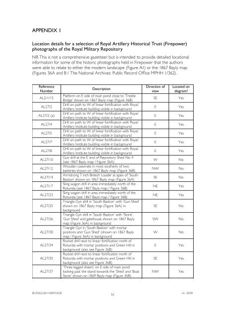
Appendix 1Location details for a selection of Royal Artillery Historical Trust (Firepower)photographs of the Royal Military RepositoryNB This is not a comprehensive gazetteer but is intended to provide detailed locationalinformation for some of the historic photographs held in Firepower that the authorswere able to relate to either the modern landscape (Figure A1) or the 1867 Bayly map(Figures 36A and B / The National Archives: Public Record Office MPHH 1/362).ReferenceNumberAL2/1/15AL27/2AL27/2 (a)AL27/4AL27/5AL27/7AL27/8AL27/10AL27/12AL27/14AL27/17AL27/23AL27/25AL27/26AL27/30AL27/34AL27/35AL27/37AL27/40AL27/41DescriptionPlatform on E side of main pond close to ‘TrestleBridge’ shown on 1867 Bayly map (Figure 36B)Drill on path to W of linear fortification with RoyalArtillery Institute building visible in backgroundDrill on path to W of linear fortification with RoyalArtillery Institute building visible in backgroundDrill on path to W of linear fortification with RoyalArtillery Institute building visible in backgroundDrill on path to W of linear fortification with RoyalArtillery Institute building visible in backgroundDrill on path to W of linear fortification with RoyalArtillery Institute building visible in backgroundDrill on path to W of linear fortification with RoyalArtillery Institute building visible in backgroundGun drill at the E end of Repository Shed No 4(see 1867 Bayly map / Figure 36A)Wooden casemate in most southerly of twobatteries shown on 1867 Bayly map (Figure 36B)Armstrong 7 inch Breech Loader at apex of ‘SouthBastion’ shown on 1867 Bayly map (Figure 36A)Sling wagon drill in area immediately north of theRotunda (see 1867 Bayly map / Figure 36B)Sling wagon drill in area immediately north of theRotunda (see 1867 Bayly map / Figure 36B)Triangle Gyn drill in ‘South Bastion’ with ‘Gun Shed’shown on 1867 Bayly map (Figure 36A) inbackgroundTriangle Gyn drill in ‘South Bastion’ with ‘Store’,‘Gun Shed’ and gatehouse shown on 1867 Baylymap (Figure 36A) in backgroundTriangle Gyn in ‘South Bastion’ with mortarpositions and ‘Gun Shed’ (shown on 1867 Baylymap / Figure 36A) in backgroundRocket drill next to linear fortification north ofRotunda with mortar positions and Green Hill inbackground (also see Figure 36B)Rocket drill next to linear fortification north ofRotunda with mortar positions and Green Hill inbackground (also see Figure 36B)‘Three legged sheers’ on E side of main pondlooking past the island towards the ‘Shed’ and ‘BoatStore’ shown on 1869 Bayly map (Figure 36B)Wooden casemate in most southerly of twobatteries shown on 1867 Bayly map (Figure 36B)Wooden casemate in most southerly of twobatteries shown on 1867 Bayly map (Figure 36B)Wooden casemate in most southerly of twobatteries shown on 1867 Bayly map (Figure 36B)Wooden casemate in most southerly of twobatteries shown on 1867 Bayly map (Figure 36B)Derrick at wooden casemate in most southerly ofDirection ofviewLocated ondiagram?© ENGLISH HERITAGE5614 - 2009AL27/42AL27/46SEEEEEEEWNWSENENESESWWESENWWNENENEYesYesYesYesYesYesYesNoNoNoYesYesNoNoNoYesYesYesNoNoNoNo


