100LR Long Range Laser - Leica Geosystems
100LR Long Range Laser - Leica Geosystems
100LR Long Range Laser - Leica Geosystems
- No tags were found...

Create successful ePaper yourself
Turn your PDF publications into a flip-book with our unique Google optimized e-Paper software.
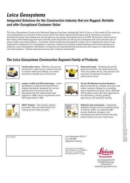
<strong>Leica</strong> <strong>Geosystems</strong>Integrated Solutions for the Construction Industry that are Rugged, Reliableand offer Exceptional Customer ValueThe <strong>Leica</strong> <strong>Geosystems</strong> Construction Business Segment has been strategically built to focus on the needs of the customer.<strong>Leica</strong> <strong>Geosystems</strong> is a pioneer of the survey world. Our history goes back 80 years and is marked by numerousdevelopments that have shaped the course taken by surveying, photogrammetry and GPS. Renowned names such asKern Aarau, Wild Heerbrugg and more recently <strong>Laser</strong> Alignment are among the companies that have become part ofwhat is today <strong>Leica</strong> <strong>Geosystems</strong>. Combined, these companies have played a major role in shaping the vision of ourorganization, deepening our knowledge of customer needs and providing market-leading product technologies andsolutions. <strong>Leica</strong> <strong>Geosystems</strong>' distribution companies and representatives provide you with support in 128 countries.<strong>Leica</strong> <strong>Geosystems</strong> – Global resources serving each customer individually.The <strong>Leica</strong> <strong>Geosystems</strong> Construction Segment Family of ProductsConstruction lasers – Whether it’s generalconstruction, pipe laying, machine control,or interior walls and ceilings, our lasersare built to handle any environment.Automatic levels – Professional opticallevels are built for the construction site.They are quickly set up, very precise, andtop every comparison of price toperformance ratios.Your Dealer:Leader in GPS and TPS technology – Usedworldwide in projects that demand thehighest standards, designed for variousapplications and ease-of-use. Wedeveloped the first reflectorless totalstations in 1998, and our experience withGPS dates back to 1967.DIGI TM System – The location systemprovides a fast and safe solution fortracing buried utility services.<strong>Leica</strong> <strong>Geosystems</strong> GR LLCis an ISO 9001Registered Company.1D and 3D Machine Control Systems –Boost productivity, increase accuracy, andreduce operator fatigue by convertingheavy equipment to laser, sonic, GPS andTPS guided control. We have applicationsfor excavating, mining, grading,agriculture, and precision paving.Software and accessories – Integratedsoftware solutions and a complete seriesof tripods, staffs, our patented 360°prisms, batteries, chargers, andeverything you need to extract the bestperformance from your instrument.Illustrations, descriptions and technical data are not binding and may be changed.Printed in Switzerland. Copyright <strong>Leica</strong> <strong>Geosystems</strong> AG, Heerbrugg, Switzerland, 2005.732054en – III.05 – RDV<strong>Laser</strong> class 1 in accordancewith IEC 60825-1 and EN 60825-1<strong>Laser</strong> class I in accordancewith FDA 21CFR CH.1 § 1040<strong>Leica</strong> <strong>Geosystems</strong> AGCH-9435 Heerbrugg(Switzerland)www.leica-geosystems.com