

Explore Mercury Orbital Data - MESSENGER :: ACT-REACT Quick ...
Explore Mercury Orbital Data - MESSENGER :: ACT-REACT Quick ...
Explore Mercury Orbital Data - MESSENGER :: ACT-REACT Quick ...

Create successful ePaper yourself
Turn your PDF publications into a flip-book with our unique Google optimized e-Paper software.
<strong>Explore</strong> <strong>Mercury</strong> <strong>Orbital</strong> <strong>Data</strong><br />
<strong>ACT</strong>-RE<strong>ACT</strong> <strong>Quick</strong> Map<br />
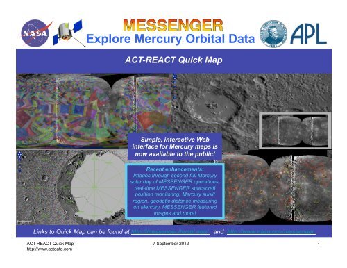
Simple, interactive Web<br />
interface for <strong>Mercury</strong> maps is<br />
now available to the public!<br />
Recent enhancements:<br />
Images through second full <strong>Mercury</strong><br />
solar day of <strong>MESSENGER</strong> operations,<br />
real-time <strong>MESSENGER</strong> spacecraft<br />
position monitoring, <strong>Mercury</strong> sunlit<br />
region, geodetic distance measuring<br />
on <strong>Mercury</strong>, <strong>MESSENGER</strong> featured<br />
images and more!<br />
Links to <strong>Quick</strong> Map can be found at http://messenger.jhuapl.edu/ and http://www.nasa.gov/messenger<br />
<strong>ACT</strong>-RE<strong>ACT</strong> <strong>Quick</strong> Map 7 September 2012<br />
http://www.actgate.com<br />
1
<strong>Explore</strong> <strong>Mercury</strong> <strong>Orbital</strong> <strong>Data</strong><br />
<strong>ACT</strong>-RE<strong>ACT</strong> <strong>Quick</strong> Map allows users to:<br />
• View areas of <strong>Mercury</strong>’s surface observed in orbit or targeted for highresolution<br />
observation by <strong>MESSENGER</strong> instruments (updated regularly).<br />
• Locate craters and other named <strong>Mercury</strong> features of interest.<br />
• <strong>Explore</strong> a global mosaic and mini-mosaics of targeted regions. The mosaics<br />
currently include a subset of orbital images acquired in the first two full<br />
<strong>Mercury</strong> solar days of <strong>MESSENGER</strong> orbital operations (through March 25,<br />
2012) and will be updated for each <strong>MESSENGER</strong> delivery to the Planetary<br />
<strong>Data</strong> System (PDS). Global mosaic is available for download.<br />
• Locate orbital images within user-defined regions of interest (ROI) and<br />
download those images from PDS. Also access observation meta-data.<br />
Watch for additional <strong>Quick</strong> Map capabilities and enhancements in the future.<br />
Links to <strong>Quick</strong> Map can be found at http://messenger.jhuapl.edu/ and http://www.nasa.gov/messenger<br />
All of the <strong>MESSENGER</strong> data archived at PDS to-date are available at http://pds.nasa.gov<br />
<strong>ACT</strong>-RE<strong>ACT</strong> <strong>Quick</strong> Map 7 September 2012<br />
http://www.actgate.com<br />
2
Create<br />
Shareable Link<br />
for Current View<br />
Choose<br />
Map<br />
Overlays<br />
<strong>Quick</strong> Map Controls<br />
Links to <strong>Quick</strong> Map can be found at http://messenger.jhuapl.edu/ and http://www.nasa.gov/messenger<br />
Choose<br />
Map<br />
Projection<br />
Navigate and<br />
Zoom<br />
Change<br />
Resolution<br />
Provide<br />
Feedback<br />
Navigate<br />
See <strong>Quick</strong>Map<br />
Overview<br />
Search User-Defined<br />
Region for Targets and<br />
Completed Observations<br />
View/Recenter<br />
View to Lat/Lon<br />
Show<br />
Context/<br />
Overview<br />
Map<br />
Startup view shows 750-nm <strong>MESSENGER</strong> <strong>Mercury</strong> orbital global mosaic created by <strong>MESSENGER</strong>/<strong>ACT</strong><br />
which includes images from the first two full <strong>Mercury</strong> solar days of <strong>MESSENGER</strong> orbital operations.<br />
<strong>ACT</strong>-RE<strong>ACT</strong> <strong>Quick</strong> Map 7 September 2012<br />
http://www.actgate.com<br />
Measure<br />
Paths<br />
3
<strong>Quick</strong> Map Layer Controls<br />
Click triangle to expand/<br />
hide Special Products<br />
layer group listing<br />
Drag to change Master<br />
Targets layer opacity<br />
Check box to display<br />
Master Targets layer<br />
in map panel<br />
Click triangle to display/hide<br />
Master Targets layer legend<br />
Click shaded bar to<br />
display/hide layers panel<br />
Example of adding a map layer: adding Master Target overlay to <strong>Mercury</strong> global mosaic. Additional special<br />
products will be added as mission progresses.<br />
<strong>ACT</strong>-RE<strong>ACT</strong> <strong>Quick</strong> Map 7 September 2012<br />
http://www.actgate.com<br />
4
Select resolution<br />
<strong>Quick</strong> Map Navigation Controls<br />
Pan view by clicking these<br />
arrows or using keyboard arrows<br />
Zoom view by sliding here<br />
Click to select MAP mode<br />
Navigate in MAP mode:<br />
• Pan view by click-and-dragging mouse on map<br />
• Redraw zoom box by shift-click-and-dragging mouse on map<br />
Lat/long view/control<br />
• Hoover cursor on map to see lat/lon position here<br />
• Enter lat/lon here and press Enter to recenter view<br />
Move zoomed region by clickand-dragging<br />
red zoom box<br />
Click here to hide/display<br />
overview map (red box<br />
indicates zoomed region)<br />
Controls for resolution, zoom, pan, lat/long sensing, and selecting and overviewing zoomed region.<br />
<strong>ACT</strong>-RE<strong>ACT</strong> <strong>Quick</strong> Map 7 September 2012<br />
http://www.actgate.com<br />
5
<strong>Quick</strong> Map Projection Controls<br />
Choose map projection<br />
Example north pole stereographic projection of MLA tracks and lat/long grid overlaid on MDIS global mosaic.<br />
<strong>ACT</strong>-RE<strong>ACT</strong> <strong>Quick</strong> Map 7 September 2012<br />
http://www.actgate.com<br />
6
Sinusoidal Projection<br />
Example sinusoidal projection of XRS coverage density overlaid on MDIS global mosaic.<br />
<strong>ACT</strong>-RE<strong>ACT</strong> <strong>Quick</strong> Map 7 September 2012<br />
http://www.actgate.com<br />
7
New: Sunlit Region and Spacecraft Tracking<br />
New <strong>Quick</strong>Map layers allow users to view the sunlit region of <strong>Mercury</strong> and monitor the position of the<br />
<strong>MESSENGER</strong> spacecraft. Users can zoom-in to see the spacecraft moving along its track in real-time.<br />
<strong>ACT</strong>-RE<strong>ACT</strong> <strong>Quick</strong> Map 7 September 2012<br />
http://www.actgate.com<br />
8
New:<br />
Featured Images from <strong>MESSENGER</strong> Website<br />
Search for featured images:<br />
a. With <strong>MESSENGER</strong> featured images layer<br />
selected, click on Search tab.<br />
b. Enter full or partial feature name (“revisiting”<br />
for this example search) and click on Find.<br />
Results are listed below where you entered search text<br />
and marked by orange rings in display. Features are<br />
highlighted in white as the cursor is hovered over their<br />
names in results list.<br />
c. Click on image of interest in Search Results<br />
list to navigate to a higher-resolution view.<br />
d. Double-click on the featured image ring to<br />
display the image and associated description<br />
from the <strong>MESSENGER</strong> website.<br />
<strong>Quick</strong>Map now allows users to locate and link to the featured images and associated descriptions from the<br />
<strong>MESSENGER</strong> website. With the satellite position layer also enabled, this view shows the <strong>MESSENGER</strong><br />
spacecraft flying by the site of the “Revisiting Boccaccio” featured image near <strong>Mercury</strong>’s south pole.<br />
<strong>ACT</strong>-RE<strong>ACT</strong> <strong>Quick</strong> Map 7 September 2012<br />
http://www.actgate.com<br />
9
Download MDIS Global Mosaic<br />
Click here to downlink<br />
MDIS global mosaic<br />
New: start and end times for data included<br />
in global mosaic and other <strong>Quick</strong> Map layers<br />
MDIS global mosaics can be downloaded from the <strong>MESSENGER</strong> website and using the <strong>Quick</strong> Map link shown<br />
here. New: time ranges for data included in global mosaic and other layers shown in information panel.<br />
<strong>ACT</strong>-RE<strong>ACT</strong> <strong>Quick</strong> Map 7 September 2012<br />
http://www.actgate.com<br />
10
Master Target Mosaics<br />
To view mini-mosaics of images satisfying targeted observations, select Master Target and Master Target Mosaic<br />
layers and resolutions of 1000 meters per pixel or higher. Mosaics include images delivered to PDS.<br />
<strong>ACT</strong>-RE<strong>ACT</strong> <strong>Quick</strong> Map 7 September 2012<br />
http://www.actgate.com<br />
11
Now supports<br />
geodetic distance<br />
measuring<br />
New: Enhanced Path Tool<br />
4. Exit path mode<br />
Example use of path button to measure cartographic and geodetic distances between Rodin and Hemingway<br />
craters on <strong>Mercury</strong>. Cartographic distance (path shown in blue) is measured on the 2-dimensional map<br />
projection. Geodetic distance (path shown in green) is measured over the surface of <strong>Mercury</strong>.<br />
<strong>ACT</strong>-RE<strong>ACT</strong> <strong>Quick</strong> Map 7 September 2012<br />
http://www.actgate.com<br />
1. Select path mode<br />
2. Click to start measurement.<br />
3. Double-click to end<br />
measurement and view<br />
results.<br />
12
Right-click and Copy Link to capture<br />
a URL for current map view<br />
<strong>Quick</strong> Map Permalink Sharing<br />
Using <strong>Quick</strong> Map permalink to save view region.<br />
<strong>ACT</strong>-RE<strong>ACT</strong> <strong>Quick</strong> Map 7 September 2012<br />
http://www.actgate.com<br />
13
<strong>Quick</strong>ly view and locate named <strong>Mercury</strong> features<br />
Check <strong>Mercury</strong> Features layer<br />
box to view feature locations,<br />
names, and meta-data<br />
<strong>Mercury</strong> Features Layer<br />
Click triangle to right of<br />
<strong>Mercury</strong> Features and select<br />
info tab for key to color<br />
coding of features by type<br />
Increase resolution to<br />
view feature names and<br />
smaller features<br />
Example view of larger features among nearly 360 International Astronomical Union (IAU) approved named<br />
<strong>Mercury</strong> features. Smaller features are displayed in higher resolution views. Feature names are displayed at<br />
2000 m/pixel and higher resolutions. See next slides for feature searches and higher resolution example.<br />
<strong>ACT</strong>-RE<strong>ACT</strong> <strong>Quick</strong> Map 7 September 2012<br />
http://www.actgate.com<br />
14
<strong>Mercury</strong> Feature Searches<br />
Search for named <strong>Mercury</strong> features:<br />
a. With <strong>Mercury</strong> features layer selected, click<br />
on Search tab.<br />
b. Enter full or partial feature name (“mo” for<br />
this example search) and click on Find.<br />
Results are listed below where you entered search<br />
text and marked by orange rings in display.<br />
Features are highlighted in white as the cursor is<br />
hovered over their names in results list.<br />
c. Click on feature of interest in Search<br />
Results list to navigate to a higherresolution<br />
view of that feature.<br />
Example <strong>Mercury</strong> feature search yields 10 features with names containing search text “mo” – shown in results list<br />
on left and with orange rings on map display. Hovering the cursor over a feature in the results list highlights that<br />
feature in white on map display – in this example the Mozart feature is highlighted. Clicking on Mozart in the<br />
Search Results list navigates to higher resolution view of that crater – see next slide.<br />
<strong>ACT</strong>-RE<strong>ACT</strong> <strong>Quick</strong> Map 7 September 2012<br />
http://www.actgate.com<br />
15
Navigating <strong>Mercury</strong> Features<br />
High-resolution view of <strong>Mercury</strong> Mozart crater navigated to via <strong>Quick</strong> Map <strong>Mercury</strong> feature search (as described<br />
on previous slide). Clicking on feature provides IAU information shown.<br />
<strong>ACT</strong>-RE<strong>ACT</strong> <strong>Quick</strong> Map 7 September 2012<br />
http://www.actgate.com<br />
16
2. Download Images<br />
from PDS<br />
Links to download images from PDS<br />
Image filenames at PDS<br />
Region of Interest (ROI) Searches<br />
Example search for images in user-defined region of interest (ROI). Links are provided to downlink images from<br />
PDS. Users can also search for targets and MASCS/VIRS observations in an ROI.<br />
<strong>ACT</strong>-RE<strong>ACT</strong> <strong>Quick</strong> Map 7 September 2012<br />
http://www.actgate.com<br />
1. Search for images in ROI<br />
a. Click on Search For and select images to search (above).<br />
b. Draw ROI box by click-and-dragging mouse on map.<br />
c. Search Results window will appear, listing requested<br />
images in ROI. Search can be iterated on same ROI for<br />
750-nm mosaic images, all NAC images, and all WAC<br />
images (as shown in this example).<br />
d. Links in search results: rightmost links enable image file<br />
downlink from PDS. Leftmost links indicate PDS image<br />
filenames which when clicked provide additional image<br />
meta-data.<br />
Now includes images from PDS delivery 8<br />
17
<strong>Quick</strong> Map Browsers<br />
<strong>ACT</strong>-RE<strong>ACT</strong> <strong>Quick</strong> Map can be used with all the major browsers:<br />
• Firefox 3 and higher<br />
• Safari<br />
• Google Chrome<br />
• Internet <strong>Explore</strong>r 8 and higher<br />
• Mobile Devices: iPad (partial functionality available)<br />
• Browser settings:<br />
• Javascript enabled<br />
• Minimum screen resolution: 800x600<br />
<strong>ACT</strong>-RE<strong>ACT</strong> <strong>Quick</strong> Map 7 September 2012<br />
http://www.actgate.com<br />
18