102 M a del Carmen Domìnguez, Adolfo Eraso(1,385-0,930 hm 3·km -2 , 2,288-1,638 hm 3·km -2 ,2,633-2,006 hm 3·km -2 ) and for the otherperiods they are represented in the followinggraphs. We observe, in all cases, a significantincrease in the course of the years we arestudying.Changes observed in the glacier icecap during the summer 2005/06Besides the evolution observed in theglacier that we have just analysed from therecorded time series, both of meteorologicaland hydraulic parameters, we observed verysignificant changes in the glacier catchmentarea that drains to the register station duringthe summer of 2005/06.Previous situationIn January, 2000, invited by the 45thRussian Antarctic Expedition, we started ourstudy of the glacier discharge of the SmallDome or Bellingshausen Dome in CollinsGlacier, at the so called “Salamanca Canyon”which pours its waters into the Drake pass.Afterwards, in consecutive years and with the2000 results, when we began with the ProjectGLACKMA, we implemented the monitoringstation (CPE-KG-62ºS) by the entry bridge tothe Uruguayan Base Artigas. It is the sameglacier in which we worked in 2000, butdischarging to Bransfield, not to Drake.This circumstance allowed us toreconnoitre, explore, position and study indepth the said Minor Dome of the glacier,locating the existing seracs and moulins anddefining the different catchment areas ofglacier drainages.From the security point of view, in theperiod from January, 2000, to February, 2005,the only places with a certain risk in the accessfrom the Fildes Peninsula to the Minor Domewere:- A moulin beside the intraglacier lake that,crossing the glacier perimetral moraine, feedsthe mentioned Salamanca Canyon in the Drakearea.- Some low entity cracks, under the snow, onboth sides of the pass that joins the MinorDome to the Central Dome of the main icecapon King George Island.Moreover, all the iced slopes on KingGeorge show seracs before reaching the sea onboth the Drake and the Bransfield side. Theseare dangerous areas. The same happens in theglacier borders of Collins Cove, Marian Coveand Potter Cove in Fildes or Maxwell Bay, andthe coves in Admiral Bay. Being known, theyare avoided by the members of the differentcrews dwelling in this part of Antarctic, wherethere are 9 opened bases during all the year.The glacier pass located on theconnections between Marian Cove in FildesBay and Ezcurra Cove in Admiral Baydeserves special attention. Here there is agroup of crevasses of considerable size thatwere located by glaciologists at King SejongBase in past years. In winter, this pass is usedfor communicating by “ground”, over theicecap, with snowmobiles crossing betweenKing Sejong and Jubany bases and the oneslocated in Fildes Peninsula. One of thosecrevasses took the lives of two Argentiniansfrom Jubany in September, 2005.In that same period, specific glacierdischarge evolution, according to the previousanalysed registers from our measuring station,has been increasing in an exponential, andduring the last summer with values closer tothose of a temperate glacier.Events observed in January 2006 in theglacier icecap on King GeorgeAppearance of new seracs- Southeast section of Yamana nunatak,Jubany slope:
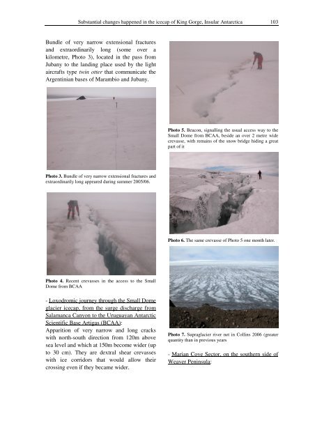
Substantial changes happened in the icecap of King Gorge, Insular Antarctica 103Bundle of very narrow extensional fracturesand extraordinarily long (some over akilometre, Photo 3), located in the pass fromJubany to the landing place used by the lightaircrafts type twin otter that communicate theArgentinian bases of Marambio and Jubany.Photo 5. Beacon, signalling the usual access way to theSmall Dome from BCAA, beside an over 2 metre widecrevasse, with remains of the snow bridge hiding a greatpart of itPhoto 3. Bundle of very narrow extensional fractures andextraordinarily long appeared during summer 2005/06.Photo 6. The same crevasse of Photo 5 one month later.Photo 4. Recent crevasses in the access to the SmallDome from BCAA- Loxodromic journey through the Small Domeglacier icecap, from the surge discharge fromSalamanca Canyon to the Uruguayan AntarcticScientific Base Artigas (BCAA):Apparition of very narrow and long crackswith north-south direction from 120m abovesea level and which at 150m become wider (upto 30 cm). They are dextral shear crevasseswith ice corridors that would allow theircrossing even if they became wider.Photo 7. Supraglacier river net in Collins 2006 (greaterquantity than in previous years- Marian Cove Sector, on the southern side ofWeaver Peninsula: