Trekking path to the southern summit of Jabal Shams from 'The ...
Trekking path to the southern summit of Jabal Shams from 'The ...
Trekking path to the southern summit of Jabal Shams from 'The ...

Create successful ePaper yourself
Turn your PDF publications into a flip-book with our unique Google optimized e-Paper software.
Al Qannah Western Hajar<br />
Yanqul<br />
Ibri<br />
Location<br />
Al Khaburah<br />
Bahla<br />
As Suwayq<br />
H A J A RR A L G H A R RRRRRR B BBBBB I<br />
JABAL SHAMS<br />
220km <strong>from</strong> Muscat (80km <strong>from</strong> Nizwa)<br />
Closest <strong>to</strong>wn: Al Hamra<br />
Follow <strong>the</strong> road <strong>from</strong> Al Hamra <strong>to</strong> Wadi<br />
Ghul, <strong>to</strong>wards <strong>the</strong> <strong>Jabal</strong> <strong>Shams</strong> ‘The<br />
Plateau’. Turn right at <strong>the</strong> road sign for<br />
Path W4 and carry on until you reach <strong>the</strong><br />
village Al Khitaym (approximately 40km<br />
<strong>from</strong> Al Hamra). The last 20km <strong>of</strong> <strong>the</strong><br />
road is graded and a 4 WD is<br />
recommended.<br />
Western Hajar Overview Map Ref. C-4<br />
Accommodation<br />
<strong>Jabal</strong> <strong>Shams</strong> Motel<br />
Hotels in Nizwa and o<strong>the</strong>r local <strong>to</strong>wns<br />
Camping<br />
Oman <strong>Trekking</strong> Explorer First Edition<br />
Copyright © Ministry <strong>of</strong> Tourism, Oman 2005<br />
All rights reserved<br />
Al Awabi<br />
Jamma<br />
Ar Rustaq<br />
Nizwa<br />
Local salesman<br />
Wukan<br />
Manah<br />
G U L h F O F O M A N<br />
Izki<br />
Barka<br />
Juzor ad<br />
Nakhal Bidbid<br />
Samail<br />
Spectacular views<br />
Useful guidebooks<br />
Adventure <strong>Trekking</strong> in Oman<br />
Oman Off-Road Explorer<br />
W4<br />
As Seeb<br />
Intl Airport<br />
Looking down almost 1,000m<br />
MUSCAT<br />
Ibra<br />
Al Qannah Western Hajar<br />
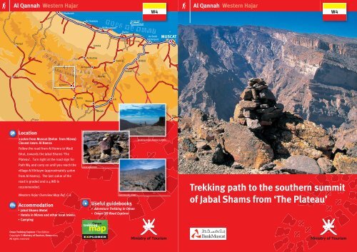
<strong>Trekking</strong> <strong>path</strong> <strong>to</strong> <strong>the</strong> sou<strong>the</strong>rn <strong>summit</strong><br />
<strong>of</strong> <strong>Jabal</strong> <strong>Shams</strong> <strong>from</strong> ‘The Plateau’<br />
W4
S<br />
!<br />
Al Qannah Western Hajar<br />
Introduction<br />
Type <strong>of</strong> trek<br />
Starting at <strong>the</strong> <strong>Jabal</strong> <strong>Shams</strong> plateau, <strong>the</strong> <strong>path</strong> follows <strong>the</strong> rim <strong>of</strong><br />
<strong>the</strong> Saydran Gorge, a side wadi <strong>of</strong> <strong>the</strong> ‘Grand Canyon’, <strong>to</strong> a col at<br />
2,700m. From <strong>the</strong>re <strong>the</strong> <strong>path</strong> levels <strong>to</strong> reach <strong>the</strong> sou<strong>the</strong>rn <strong>summit</strong><br />
<strong>of</strong> <strong>Jabal</strong> <strong>Shams</strong> (Qarn al Ghamaydah) at an altitude <strong>of</strong> 2,997m.<br />
Mostly a natural, rocky trek <strong>to</strong> <strong>the</strong> highest point in Oman.<br />
Highlights<br />
The <strong>to</strong>ur allows spectacular views in<strong>to</strong> Wadi Nakhar, <strong>the</strong> ‘Grand<br />
Canyon’, Wadi as Sahtan and Wadi Bani Awf, as well as fantastic<br />
views <strong>of</strong> <strong>Jabal</strong> Khawr and <strong>Jabal</strong> Misht in <strong>the</strong> distance. On clear<br />
days you can even see <strong>the</strong> sea in <strong>the</strong> distance.<br />
Starting point (GPS UTM 520,697E 2,568,658N)<br />
At <strong>the</strong> information sign W4, along <strong>the</strong> road <strong>to</strong> ‘The Plateau’.<br />
Tip<br />
Trek Directions<br />
From <strong>the</strong> parking area, follow <strong>the</strong> coloured markers across <strong>the</strong> s<strong>to</strong>ny plain,<br />
crossing a small wadi and continuing along <strong>the</strong> rim <strong>of</strong> <strong>the</strong> Saydran Gorge,<br />
until joining a wadi which leads <strong>to</strong> <strong>the</strong> first col at 2,700m. There are<br />
very good views east at this point. From <strong>the</strong> col, <strong>the</strong> <strong>path</strong> turns south<br />
and mainly follows <strong>the</strong> crest <strong>of</strong> <strong>the</strong> ridge, arriving at <strong>the</strong> <strong>summit</strong><br />
after approximately four kilometres. To descend, you must return<br />
on <strong>the</strong> same route.<br />
This is by far <strong>the</strong> best walk <strong>to</strong> <strong>the</strong> <strong>to</strong>p <strong>of</strong> <strong>Jabal</strong> <strong>Shams</strong> (Qarn al<br />
Ghamaydah). The walk is relatively easy, and <strong>the</strong> views are<br />
simply spectacular.<br />
Dar as Sawdah<br />
Wadi Ghul 30km<br />
‘THE PLATEAU’<br />
The Plateau<br />
30km<br />
Wadi Ghul<br />
Rug weavers<br />
Rug weavers<br />
<strong>Jabal</strong> <strong>Shams</strong><br />
Motel<br />
P<br />
Al Khitaym<br />
alt.1,900m<br />
alt. 1,950m<br />
Closed road<br />
Wadi Ghul<br />
alt. 750m<br />
An Nakhur<br />
alt. 900m<br />
Al Hamra 10km<br />
Nizwa 57km<br />
PLEASE TAKE ONLY PICTURES, LEAVE ONLY FOOTPRINTS AND TAKE YOUR RUBBISH TO THE NEAREST BIN.<br />
W6a<br />
Abandoned<br />
villages<br />
P<br />
S<br />
W4<br />
W4<br />
Al HaylJABAL SHAMS<br />
WADI AN NAKHUR<br />
‘GRAND CANYON’<br />
W6<br />
P<br />
Rug weavers<br />
Al Hajir<br />
alt. 800m<br />
Abandoned<br />
village<br />
Juniper Trees<br />
S<br />
Juniper Trees<br />
Starting point<br />
<strong>Trekking</strong> <strong>path</strong><br />
Driveable track (4 WD)<br />
Main road<br />
S<strong>to</strong>ne house<br />
Trek Summary<br />
Restricted Area<br />
alt. 2,700m<br />
Timing<br />
Ascent: 5 – 6 hours with<br />
light pack, or 6 – 7 hours<br />
with camping equipment<br />
Descent: 4.5 – 5.5 hours<br />
Altitude<br />
Highest point 2,997m<br />
Difference 1,000m<br />
N<br />
500m<br />
W4<br />
Qarn al<br />
Ghamaydah<br />
alt. 2,997m<br />
Scenic view<br />
Camping site<br />
Accommodation<br />
Via Ferrata<br />
Degree <strong>of</strong> difficulty<br />
Grade 2<br />
A long mountain trek;<br />
rocky, partly steep but<br />
relatively easy going.<br />
Distance<br />
9.km
Wadi Mistall Western Hajar<br />
Yanqul<br />
Ibri<br />
Location<br />
Al Khaburah<br />
Al Hamra<br />
Bahla<br />
As Suwayq<br />
H A J AA R AAA L G H A AAA R B IIII<br />
JABAL SHAMS<br />
140km <strong>from</strong> Muscat (56km <strong>from</strong> Nakhal)<br />
A 4 WD vehicle is recommended, as 40km<br />
<strong>of</strong> <strong>the</strong> road is graded.<br />
Western Hajar Overview Map Ref. N-6, P-6<br />
Accommodation<br />
You can do this trek as a daytrip, or use<br />
<strong>the</strong> following accommodation options:<br />
Sawadi Beach Resort (On <strong>the</strong> coast near<br />
Al Musanaah)<br />
Camping<br />
Oman <strong>Trekking</strong> Explorer First Edition<br />
Copyright © Ministry <strong>of</strong> Tourism, Oman 2005<br />
All rights reserved<br />
Al Awabi<br />
Jamma<br />
Ar Rustaq<br />
Nizwa<br />
Manah<br />
Slightly difficult passage - W25<br />
G U L h F O F O M A N<br />
Izki<br />
Barka<br />
Juzor ad<br />
Nakhal Bidbid<br />
Sunrise<br />
Samail<br />
Useful guidebooks<br />
Adventure <strong>Trekking</strong> in Oman<br />
Off-Road Explorer (Oman)<br />
W25/24a<br />
As Seeb<br />
Intl Airport<br />
Falaj on W25<br />
MUSCAT<br />
Ibra<br />
Wadi Mistall Western Hajar<br />
<strong>Trekking</strong> <strong>path</strong> <strong>from</strong> Wukan <strong>to</strong><br />
Hadash via <strong>the</strong> north flank <strong>of</strong> <strong>the</strong><br />
Sayq Plateau<br />
W25/24a
Wadi Mistall Western Hajar<br />
Introduction<br />
Type <strong>of</strong> trek<br />
A challenging mountain trek, partly along an old donkey <strong>path</strong>.<br />
Highlights<br />
The <strong>to</strong>ur allows spectacular views in<strong>to</strong> Wadi Mistall and <strong>the</strong><br />
Gubrah Bowl, as well as good views over <strong>the</strong> Sayq Plateau.<br />
S<br />
!<br />
Starting point (GPS UTM 575,247E 2,559,593N)<br />
Parking area in Wukan marked with information sign W25.<br />
Tip<br />
Trek directions<br />
The marked <strong>path</strong> starts <strong>from</strong> <strong>the</strong> village <strong>of</strong> Wukan and winds through <strong>the</strong><br />
gardens along <strong>the</strong> falaj irrigation system. In <strong>the</strong> village, approximately 100m<br />
<strong>from</strong> <strong>the</strong> parking area, <strong>the</strong>re is a turn <strong>of</strong>f <strong>to</strong> <strong>the</strong> left marked W24b, which leads<br />
Qarn Wukan<br />
<strong>to</strong> Al Qawrah (approximately 15 minutes <strong>of</strong> walking time) and fur<strong>the</strong>r <strong>to</strong><br />
alt. 2,501m<br />
Hadash (approximately three hours <strong>of</strong> walking time). This is <strong>the</strong> lower <strong>path</strong><br />
connecting <strong>the</strong> villages. Follow W25 <strong>to</strong> <strong>the</strong> little mosque above <strong>the</strong> palm<br />
gardens (<strong>from</strong> here it is also possible <strong>to</strong> walk straight down <strong>to</strong> Al Qawrah along<br />
an unmarked trail). Continuing on W25 you have <strong>to</strong> pass two places where <strong>the</strong><br />
<strong>path</strong> becomes exposed and you may want <strong>to</strong> take a rope (five <strong>to</strong> ten metres long) for<br />
inexperienced trekking companions. Once you reach <strong>the</strong> <strong>to</strong>p <strong>of</strong> <strong>the</strong> <strong>Jabal</strong> Ahkdar (at an<br />
altitude <strong>of</strong> 2,000m) <strong>the</strong> trail levels, and after 2.5km you’ll find <strong>the</strong> junction <strong>of</strong> Al<br />
Manakir/Hadash. The trail <strong>to</strong> Al Manakir is unmarked and turns <strong>to</strong> <strong>the</strong> south, <strong>the</strong> trail <strong>to</strong><br />
Hadash (W24a) is marked and turns <strong>to</strong> <strong>the</strong> north. After a fur<strong>the</strong>r 2km you will find a good spot<br />
for camping, just before <strong>the</strong> <strong>path</strong> drops steeply down <strong>to</strong> Hadash.<br />
This is a round trip if you include W24b <strong>from</strong> Hadash <strong>to</strong> Wukan via Al Qawrah. You can exchange car keys<br />
if a second party starts <strong>from</strong> Hadash and walks <strong>to</strong> Wukan. If you wish <strong>to</strong> return <strong>to</strong> <strong>the</strong> starting point <strong>of</strong><br />
<strong>the</strong> trek, plan for an additional 2.5 – 3 hours walking time.<br />
Sayq Plateau 10km<br />
Birkat Al Mawz 30km<br />
Wukan<br />
alt. 1,500m<br />
W25<br />
Al Aqur<br />
alt. 1,100m<br />
PLEASE TAKE ONLY PICTURES, LEAVE ONLY FOOTPRINTS AND TAKE YOUR RUBBISH TO THE NEAREST BIN.<br />
) ) ( (<br />
Wukan Pass<br />
alt. 2,300m<br />
Al Hijar<br />
P<br />
S<br />
Al Qawrah<br />
alt. 1,400m<br />
alt. 2,300m<br />
) )( (<br />
Path <strong>to</strong> Al Manakir<br />
approx. 1.5 hours<br />
(unmarked)<br />
Al Manakir<br />
alt. 1,850 m<br />
W24b<br />
Village<br />
ruins<br />
W24a<br />
Hadash Pass<br />
alt. 2,300m<br />
Ar Rustaq 65km<br />
Nakhal 43km<br />
Wadi Mistall<br />
Hadash<br />
alt. 1,500m<br />
S<br />
Starting point<br />
<strong>Trekking</strong> <strong>path</strong><br />
Foot<strong>path</strong> unmarked<br />
Driveable track (4 WD)<br />
Main road<br />
Trek Summary<br />
Timing<br />
7 – 10 hours<br />
Degree <strong>of</strong> difficulty<br />
Grade 2 <strong>to</strong> 3<br />
A mountain trek; rocky,<br />
partly steep with two<br />
exposed passages. For<br />
experienced trekkers only.<br />
W25/24a<br />
N<br />
1km<br />
S<strong>to</strong>ne house<br />
Scenic view<br />
Camping site<br />
Farm<br />
Altitude<br />
Highest point: 2,000m<br />
Difference: 500m<br />
Distance<br />
14km
Wadi Mistall Western Hajar<br />
Yanqul<br />
Ibri<br />
Location<br />
Al Khaburah<br />
Al Hamra<br />
Bahla<br />
As Suwayq<br />
H A J A RR AAA L G G GGG H HHHHH A AAA R B BBBBB I<br />
JABA L SHAMS<br />
140km <strong>from</strong> Muscat (56km <strong>from</strong> Nakhal)<br />
A 4 WD vehicle is recommended, as<br />
40km <strong>of</strong> <strong>the</strong> road is graded.<br />
Western Hajar Overview Map Ref. P-6<br />
Accommodation<br />
You can make this a daytrip <strong>from</strong><br />
Muscat or use <strong>the</strong> following<br />
accommodation options:<br />
Sawadi Beach Resort (On <strong>the</strong> coast near<br />
Al Musanaah)<br />
Camping<br />
Oman <strong>Trekking</strong> Explorer First Edition<br />
Copyright © Ministry <strong>of</strong> Tourism, Oman 2005<br />
All rights reserved<br />
Al Awabi<br />
Jamma<br />
Ar Rustaq<br />
Nizwa<br />
Wukan village<br />
Wukan<br />
Manah<br />
G U L h F O F O M A N<br />
Izki<br />
Barka<br />
Juzor ad<br />
Nakhal Bidbid<br />
Samail<br />
On <strong>the</strong> <strong>path</strong><br />
Useful guidebooks<br />
Adventure <strong>Trekking</strong> in Oman<br />
Off-Road Explorer (Oman)<br />
W24b<br />
As Seeb<br />
Intl Airport<br />
Falaj system<br />
MUSCAT<br />
Ibra<br />
Wadi Mistall Western Hajar<br />
<strong>Trekking</strong> <strong>path</strong> <strong>from</strong> Hadash <strong>to</strong><br />
Wukan via Al Qawrah<br />
W24b
Wadi Mistall Western Hajar<br />
Introduction<br />
Type <strong>of</strong> trek<br />
An old <strong>path</strong> connecting three villages, which leads over several<br />
cols (steep high passes) and mountain passes.<br />
Highlights<br />
The <strong>to</strong>ur allows good views in<strong>to</strong> Wadi Mistall and <strong>the</strong> Gubrah<br />
Bowl, and leads through beautiful gardens.<br />
S<br />
!<br />
Starting point (GPS UTM 577,383E 2,557,779N)<br />
Parking area in Hadash, marked with information sign W24a/W24b; or<br />
alternatively in Wukan, marked with information sign W25/W24b.<br />
Tip<br />
Trek directions<br />
The yellow/white/red marked trek W24b starts <strong>from</strong> <strong>the</strong> parking area at <strong>the</strong><br />
village <strong>of</strong> Hadash. It follows <strong>the</strong> road until it leaves <strong>the</strong> village, taking you through<br />
Al Qawrah and on <strong>to</strong> Wukan. In some places <strong>the</strong> <strong>path</strong> is exposed <strong>to</strong> heights,<br />
and you may want <strong>to</strong> take a rope (five <strong>to</strong> ten metres long) for<br />
inexperienced trekking companions. The return route follows <strong>the</strong><br />
same <strong>path</strong>, or you can go in two groups, starting at opposite ends,<br />
and exchange car keys along <strong>the</strong> way.<br />
Al Qawrah has a delightful garden/farming area which you cross along <strong>the</strong> way.<br />
From <strong>the</strong>re you can also walk down <strong>the</strong> wadi, arriving at <strong>the</strong> split in <strong>the</strong> main road after<br />
approximately 1.5 hours. If you are lucky enough <strong>to</strong> be trekking in February, you’ll get<br />
<strong>to</strong> see <strong>the</strong> trees flowering with spring blossoms.<br />
Qarn Wukan<br />
alt. 2,501 m<br />
Sayq Plateau 10km<br />
Birkat al Mawz 30km<br />
Wukan<br />
alt. 1,500m<br />
W25<br />
Al Aqur<br />
alt. 1,100 m<br />
W24b<br />
PLEASE TAKE ONLY PICTURES, LEAVE ONLY FOOTPRINTS AND TAKE YOUR RUBBISH TO THE NEAREST BIN.<br />
) )( (<br />
Wukan Pass<br />
alt. 2,300m<br />
P<br />
Al Qawrah<br />
alt. 1,400m<br />
Al Hijar<br />
alt. 2,300m<br />
) )( (<br />
Village<br />
ruins<br />
Path <strong>to</strong> Al Manakhir<br />
approx. 1.5 hours,<br />
(unmarked)<br />
Al Manakhir<br />
alt. 1,850m<br />
Hadash Pass<br />
alt. 2,300m<br />
W24a<br />
Ar Rustaq 65km<br />
Nakhal 43km<br />
S<br />
Wadi Mistall<br />
Hadash<br />
alt. 1,500m<br />
S<br />
Starting point<br />
<strong>Trekking</strong> <strong>path</strong><br />
Foot<strong>path</strong> unmarked<br />
Driveable track (4 WD)<br />
Main Road<br />
Trek Summary<br />
Timing<br />
2.5 – 3 hours (one way)<br />
Degree <strong>of</strong> difficulty<br />
Grade 2 – 3<br />
A mountain trek; rock and<br />
gravel, partly steep with<br />
exposed passages.<br />
W24b<br />
Altitude<br />
Highest point: 1,500m<br />
Difference : 300m<br />
Distance<br />
4km<br />
N<br />
1km<br />
S<strong>to</strong>ne house<br />
Scenic view<br />
Camping site<br />
Farm
Al <strong>Jabal</strong> al Akhdar Western Hajar<br />
Yanqul<br />
Ibri<br />
Location<br />
Al Khaburah<br />
150km <strong>from</strong> Muscat (55km <strong>from</strong> Nizwa)<br />
Western Hajar Overview Map Ref. M-7<br />
Accommodation<br />
Hotel Al <strong>Jabal</strong> al Akhdar and<br />
guesthouses (Map Ref. M-7)<br />
Hotels in Nizwa and o<strong>the</strong>r local <strong>to</strong>wns<br />
Oman <strong>Trekking</strong> Explorer First Edition<br />
Copyright © Ministry <strong>of</strong> Tourism, Oman 2005<br />
All rights reserved<br />
Al Hamra<br />
Bahla<br />
As Suwayq<br />
Jamma<br />
HHHHH AAAA JJJ AAA RRR A LLLL G G GGGG H A AAAAAA R R B BB I<br />
Ar Rustaq<br />
Terrace falaj<br />
Al Awabi<br />
Manah<br />
G U L h F O F O M A N<br />
Izki<br />
Barka<br />
Juzor ad<br />
Nakhal Bidbid<br />
Samail<br />
Winter terraces<br />
Useful guidebooks<br />
Adventure <strong>Trekking</strong> in Oman<br />
Off-Road Explorer (Oman)<br />
W18b<br />
As Seeb<br />
Intl Airport<br />
Spring blossoms<br />
MUSCAT<br />
Ibra<br />
Al <strong>Jabal</strong> al Akhdar Western Hajar<br />
<strong>Trekking</strong> <strong>path</strong> through Al <strong>Jabal</strong><br />
al Akhdar Villages<br />
W18b
Al <strong>Jabal</strong> al Akhdar Western Hajar<br />
Introduction<br />
Type <strong>of</strong> trek<br />
An easy walk at high altitude <strong>from</strong> <strong>the</strong> village <strong>of</strong> Al Aqur <strong>to</strong> Sayq or<br />
vice versa, following old <strong>path</strong>s linking mountain villages.<br />
Highlights<br />
An interesting walk through mountain villages with terraced<br />
farms and ancient falaj irrigation systems; with magnificent views<br />
over Wadi Muhaydin. Look out for fossilised coral, and <strong>the</strong> chance<br />
<strong>to</strong> see a rose water distillery in action.<br />
S<br />
!<br />
Starting point (GPS UTM 568,703E 2,551,425N)<br />
From <strong>the</strong> road 4km after <strong>the</strong> Hotel Al <strong>Jabal</strong> al 6km walk <strong>to</strong><br />
Akhdar, marked with road signs and<br />
Wadi Bani Habib<br />
information signs W18b, ei<strong>the</strong>r <strong>from</strong> Al Aqur<br />
(unmarked)<br />
or <strong>from</strong> Sayq.<br />
Sayq<br />
Trek directions<br />
Wadi Bani Habib 5km<br />
farms<br />
From <strong>the</strong> information sign follow <strong>the</strong><br />
coloured markers. You may also<br />
shorten <strong>the</strong> trip if necessary, as all<br />
Shop<br />
villages on <strong>the</strong> way have road access Rose water<br />
and it’s possible <strong>to</strong> pick up <strong>the</strong> trail distillation plant<br />
<strong>from</strong> all four villages. Be considerate, as<br />
<strong>the</strong>re are many times when you will cross<br />
W18b<br />
private property. Do not take any fruits as <strong>the</strong>y are<br />
part <strong>of</strong> village livelihoods. You can also walk <strong>from</strong> ‘The Plateau’ down <strong>to</strong>wards<br />
Birkat al Mawz using <strong>the</strong> ancient <strong>path</strong> through Wadi Muhaydin. For this route, plan for 7 – 8 hours walking<br />
time. Alternatively, shorten <strong>the</strong> route by taking a 4 WD <strong>to</strong> <strong>the</strong> village <strong>of</strong> Masirat ar Rawajih. The walk<br />
<strong>from</strong> <strong>the</strong>re will take around 3 – 4 hours.<br />
Tip<br />
In mountain villages, changing seasons are accompanied by different crops and <strong>the</strong> ripening <strong>of</strong><br />
various fruits. This is one <strong>of</strong> <strong>the</strong> best walks in <strong>the</strong> whole <strong>of</strong> Oman as it is easy going and every<br />
season brings a new surprise!<br />
Ash Shirayjah<br />
Falaj<br />
Shop<br />
PLEASE TAKE ONLY PICTURES, LEAVE ONLY FOOTPRINTS AND TAKE YOUR RUBBISH TO THE NEAREST BIN.<br />
N<br />
500m<br />
S<br />
Starting point<br />
<strong>Trekking</strong> <strong>path</strong><br />
Main roads<br />
P<br />
Driveable track (4 WD)<br />
P<br />
P<br />
Al Ayn<br />
Fossils<br />
Terraced farms<br />
S<strong>to</strong>ne house<br />
Scenic view<br />
Parking<br />
Fossils<br />
Al Aqur<br />
S<br />
Trek Summary<br />
Timing<br />
2 hours (one way only)<br />
Degree <strong>of</strong> difficulty<br />
Grade 1<br />
A foot<strong>path</strong> through<br />
villages and gardens;<br />
easy going.<br />
P<br />
W18b<br />
Al <strong>Jabal</strong> al Akhdar<br />
Hotel 4km<br />
Restaurant<br />
Al Qasha 2km, Sallut 5km,<br />
Masirat ar Rawajih 9km<br />
Altitude<br />
Highest point: 2,000m<br />
Difference: 100m<br />
Distance<br />
4km
Sharaf al Alamayn Western Hajar<br />
Yanqul<br />
Ibri<br />
Al Khaburah<br />
H A J AA RR A L G G GGGGG H A<br />
Al Hamra<br />
Location<br />
210km <strong>from</strong> Muscat via Nizwa<br />
(70km <strong>from</strong> Nizwa)<br />
A 4 WD vehicle is necessary as 15km <strong>of</strong><br />
<strong>the</strong> road is graded.<br />
170km <strong>from</strong> Muscat via Nakhal<br />
(97km <strong>from</strong> Nakhal)<br />
A 4 WD vehicle is necessary as 50km <strong>of</strong><br />
<strong>the</strong> road is graded.<br />
Closest <strong>to</strong>wn: Al Hamra<br />
Western Hajar Overview Map Ref. G-5<br />
Accommodation<br />
Hotels in Nizwa, Bahla and o<strong>the</strong>r<br />
local <strong>to</strong>wns<br />
Motel at <strong>the</strong> entrance <strong>of</strong> Wadi Bani Awf<br />
(Map Ref. H-1)<br />
Camping<br />
Oman <strong>Trekking</strong> Explorer First Edition<br />
Copyright © Ministry <strong>of</strong> Tourism, Oman, 2005<br />
All rights reserved<br />
Bahla<br />
Al Awabi<br />
As Suwayq<br />
Jamma<br />
Ar Rustaq<br />
Nizwa<br />
On <strong>the</strong> <strong>path</strong><br />
Manah<br />
G U L h F O F O M A N<br />
Izki<br />
Barka<br />
Juzor ad<br />
Nakhal Bidbid<br />
Samail<br />
Checking route details<br />
Useful guidebooks<br />
Adventure <strong>Trekking</strong> in Oman<br />
Off-Road Explorer (Oman)<br />
W10h<br />
As Seeb<br />
Intl Airport<br />
On <strong>to</strong>p <strong>of</strong> <strong>the</strong> world<br />
MUSCAT<br />
Ibra<br />
Sharaf al Alamayn Western Hajar<br />
W10h<br />
<strong>Trekking</strong> <strong>path</strong> <strong>from</strong> Sharaf al Alamayn<br />
<strong>to</strong> <strong>the</strong> junction with W9 and W8
Sharaf al Alamayn Western Hajar<br />
Introduction<br />
Type <strong>of</strong> trek<br />
An airy, high altitude walk.<br />
Highlights<br />
The trek affords some <strong>of</strong> <strong>the</strong> best views in<strong>to</strong> <strong>the</strong> wadis on <strong>the</strong><br />
nor<strong>the</strong>rn side <strong>of</strong> <strong>the</strong> Western Hajar mountains.<br />
S<br />
!<br />
Starting point (GPS UTM 542,500E 2,562,078N)<br />
Take <strong>the</strong> road <strong>from</strong> Al Hamra <strong>to</strong> Hat, or alternatively <strong>from</strong> Wadi Bani Awf past Hat <strong>to</strong>wards Al Hamra;<br />
this is a graded road and you need <strong>to</strong> travel <strong>to</strong> <strong>the</strong> highest point. Near Sharaf al Alamayn look for<br />
<strong>the</strong> information sign W10h.<br />
Tip<br />
Trek Directions<br />
From <strong>the</strong> parking area, follow <strong>the</strong> coloured markers (W10h) along <strong>the</strong> crest <strong>of</strong> <strong>the</strong> hills<br />
<strong>to</strong>wards <strong>the</strong> west. The return route follows <strong>the</strong> same <strong>path</strong>, or alternatively you can<br />
continue on treks W8 or W9.<br />
Even in <strong>the</strong> hotter months it is possible <strong>to</strong> trek<br />
along this <strong>path</strong> as <strong>the</strong> temperature is rarely<br />
excessive. Note that after rainfall,<br />
<strong>the</strong> graded road leading up <strong>from</strong><br />
Misfat<br />
Hat can be very difficult <strong>to</strong> drive,<br />
al Abriyyin<br />
even with a 4 WD.<br />
alt. 950m<br />
P<br />
Al Hamra 4km<br />
Nizwa 55km<br />
Aqbat al Hamra<br />
Farm<br />
Hayl al Jawari<br />
PLEASE ONLY TAKE PICTURES, LEAVE ONLY FOOTPRINTS AND TAKE YOUR RUBBISH TO THE NEAREST BIN.<br />
W9<br />
9km<br />
S<br />
Starting point<br />
<strong>Trekking</strong> <strong>path</strong><br />
Foot<strong>path</strong> unmarked<br />
Driveable track (4 WD)<br />
Main road<br />
Ar Rustaq 35km<br />
Nakhal 56km<br />
Muscat 136km<br />
Balad Sayt<br />
alt. 950m<br />
Ruined P<br />
settlement<br />
alt. 1,650m<br />
W8<br />
alt. 2,179m<br />
alt. 2,000m<br />
P<br />
Farm<br />
5km<br />
School<br />
W10h<br />
S<strong>to</strong>ne house<br />
Scenic view<br />
Camping site<br />
Parking<br />
3.5km<br />
Hat<br />
alt. 1,000m<br />
P<br />
alt. 2,050m<br />
Trek Summary<br />
Timing<br />
1.5 – 2 hours<br />
(one way only)<br />
Degree <strong>of</strong> difficulty<br />
Grade 1<br />
Partly goat <strong>path</strong>s; rocky,<br />
but easy walking.<br />
S<br />
P<br />
Al Hamra 25km<br />
Nizwa 70km<br />
W10h<br />
N<br />
1km<br />
Sharaf<br />
al Alamayn<br />
alt. 2,000m<br />
Altitude<br />
Highest point: 2,000m<br />
Difference: 100m<br />
Distance<br />
3.5km
Wadi Tiwi/Wadi Bani Khalid Eastern Hajar<br />
Introduction<br />
Type <strong>of</strong> trek<br />
A classic traverse <strong>of</strong> <strong>the</strong> Eastern Hajar mountains, <strong>from</strong> <strong>the</strong> green oasis <strong>of</strong> Wadi Bani Khalid <strong>to</strong><br />
<strong>the</strong> coastal <strong>to</strong>wn <strong>of</strong> Tiwi, along an ancient donkey trail.<br />
Highlights<br />
Beautiful sunrises and sunsets <strong>from</strong> <strong>the</strong> highest points (over 2,000m), breathtaking views in<strong>to</strong><br />
<strong>the</strong> green wadis and dramatic canyons, and lots <strong>of</strong> free-roaming donkeys.<br />
S<br />
!<br />
Starting point (GPS UTM Wadi Tiwi 728,712E 2,521,498N, Wadi Bani Khalid 715,262E 2,502,304N)<br />
From <strong>the</strong> Wadi Tiwi side, start <strong>from</strong> <strong>the</strong> village <strong>of</strong> Al Aqur or <strong>from</strong> Sooee.<br />
From <strong>the</strong> Wadi Bani Khalid side, start after <strong>the</strong> village <strong>of</strong> Miqil by <strong>the</strong> pools.<br />
From ei<strong>the</strong>r side, <strong>the</strong>re is a parking area <strong>of</strong>f <strong>the</strong> road, marked with information sign E35.<br />
Tip<br />
Trek directions<br />
Follow <strong>the</strong> painted markers and cairns. The <strong>to</strong>ur crosses barren landscape and it is <strong>the</strong>refore<br />
essential <strong>to</strong> take enough water for <strong>the</strong> whole trip. You are best advised <strong>to</strong> ei<strong>the</strong>r organise your<br />
own donkey transport, <strong>from</strong> any <strong>of</strong> <strong>the</strong> nearby villages/settlements (be prepared <strong>to</strong> negotiate <strong>the</strong><br />
price), or contact one <strong>of</strong> <strong>the</strong> <strong>to</strong>ur opera<strong>to</strong>rs <strong>of</strong>fering trekking <strong>to</strong>urs. You may decide <strong>to</strong> do just <strong>the</strong><br />
beginning <strong>of</strong> <strong>the</strong> trek, and <strong>the</strong>refore walk for a few hours only, returning <strong>the</strong> same day. The walk<br />
<strong>from</strong> Al Aqur <strong>to</strong> Sooee is easy and particularly interesting, as is <strong>the</strong> first part <strong>of</strong> <strong>the</strong> trail <strong>from</strong> Wadi<br />
Bani Khalid, which overlooks <strong>the</strong> pools and <strong>the</strong> canyon.<br />
In order <strong>to</strong> get an early start for <strong>the</strong> trek, camp out under <strong>the</strong> palm trees by <strong>the</strong> pools <strong>of</strong> Wadi Bani<br />
Khalid, or on one <strong>of</strong> <strong>the</strong> many beaches or rocky outcrops and cliffs along <strong>the</strong> coast near Tiwi. Note that<br />
transport at <strong>the</strong> end <strong>of</strong> <strong>the</strong> trek will need <strong>to</strong> be arranged. You might consider trekking in two groups,<br />
starting at opposite ends <strong>of</strong> <strong>the</strong> trek and exchanging car keys (each group should carry a duplicate set<br />
<strong>of</strong> keys) at <strong>the</strong> midway point. Ano<strong>the</strong>r possibility is <strong>to</strong> drive in a 4 WD <strong>from</strong> Qalhat <strong>to</strong>wards <strong>the</strong> village<br />
Kibdiyah, but turn right after five or six kilometres. This driveable trek (one difficult passage) leads up<br />
<strong>the</strong> plateau, eventually meeting <strong>the</strong> trekking <strong>path</strong> E35 (after about 25km) at an altitude <strong>of</strong> 1,900m. You<br />
can ei<strong>the</strong>r walk <strong>from</strong> <strong>the</strong>re or pick up friends arriving <strong>the</strong>re.<br />
Pools<br />
P<br />
S<br />
Cave<br />
Sur 140km<br />
Muscat 235km<br />
Miqil<br />
alt. 600m<br />
N<br />
5km<br />
alt. 1,000m<br />
Wadi Absan<br />
Wadi Bani<br />
Khalid<br />
alt. 1,500m<br />
alt. 2,000m<br />
alt. 2,000m<br />
Highest Point<br />
alt. 2,100m<br />
alt. 2,000m<br />
PLEASE TAKE ONLY PICTURES, LEAVE ONLY FOOTPRINTS AND TAKE YOUR RUBBISH TO THE NEAREST BIN.<br />
Muscat 170km<br />
Wadi Ash Shaab<br />
Sooee<br />
alt. 200m<br />
Sayma<br />
Wadi<br />
Tiwi<br />
Al Aqu<br />
S<br />
S<br />
E35<br />
Starting point<br />
<strong>Trekking</strong> <strong>path</strong><br />
Tiwi<br />
alt. 500m<br />
Foot<strong>path</strong> unmarked<br />
Driveable track (4 WD)<br />
Main Road<br />
Trek Summary<br />
alt. 1,000m<br />
alt. 1,500m<br />
Timing<br />
14 hours with light pack,<br />
up <strong>to</strong> 18 hours with<br />
camping equipment.<br />
Degree <strong>of</strong> difficulty<br />
Grade 2 – 3<br />
A very long mountain trek;<br />
rocky, partly steep but<br />
relatively easy going.<br />
‘Panorama Road’<br />
Qalhat 20km<br />
E35<br />
GULF OF<br />
OMAN<br />
Sur 54km<br />
Scenic view<br />
Camping site<br />
Accommodation<br />
Farm<br />
S<strong>to</strong>ne house<br />
Altitude<br />
Highest point: 2,100m<br />
Difference: 1,800m<br />
Distance<br />
28km
Al Hamra<br />
Bahla<br />
Wadi Tiwi/Wadi Bani Khalid Eastern Hajar<br />
Ar Rustaq<br />
HH A J AA R A L G HH A RRR B II<br />
Al Awabi<br />
Nizwa<br />
Adam<br />
Location<br />
Izki<br />
Nakhal<br />
Sinaw<br />
Samail<br />
Bidbid<br />
Al Mudaybi<br />
Wadi Tiwi<br />
165km <strong>from</strong> Muscat via Qurayyat (55km<br />
<strong>of</strong> which is graded road, so a 4 WD<br />
vehicle is recommended).<br />
Wadi Bani Khalid<br />
245km <strong>from</strong> Muscat via Ibra<br />
Closest Towns<br />
Tiwi, Sur, Wadi Bani Khalid<br />
Accommodation<br />
Hotels in Sur<br />
Hotels along <strong>the</strong> inland road <strong>to</strong> Sur<br />
Camping<br />
Oman <strong>Trekking</strong> Explorer First Edition<br />
Copyright © Ministry <strong>of</strong> Tourism, Oman 2005<br />
All rights reserved<br />
Ibra<br />
Tiwi Village<br />
Qurayyat<br />
AAAA L H AAA J A<br />
Al Amintarib<br />
Al Kamil<br />
View over <strong>the</strong> village<br />
Useful guidebooks<br />
Adventure <strong>Trekking</strong> in Oman<br />
Off-Road Explorer (Oman)<br />
Al Wafi<br />
Sur<br />
E35<br />
G U L F O F O M A N<br />
Looking down on Wadi Tiwi<br />
Wadi Tiwi/Wadi Bani Khalid Eastern Hajar<br />
<strong>Trekking</strong> <strong>path</strong> <strong>from</strong> Wadi Tiwi <strong>to</strong><br />
Wadi Bani Khalid<br />
E35