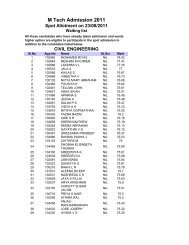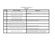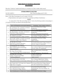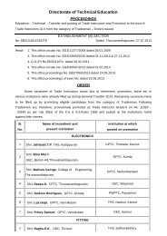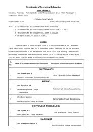
prospectus for b.tech lateral entry course - Directorate of Technical ...
prospectus for b.tech lateral entry course - Directorate of Technical ...
prospectus for b.tech lateral entry course - Directorate of Technical ...

Create successful ePaper yourself
Turn your PDF publications into a flip-book with our unique Google optimized e-Paper software.
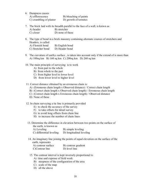
6. Dampness causesA) efflorescence B) bleaching <strong>of</strong> paintsC) crumbling <strong>of</strong> plaster D) growth <strong>of</strong> termites7. The brick laid with its breadth parallel to the face <strong>of</strong> a wall, is kniwn asA) header B) stretcherC) closer D) none <strong>of</strong> these8. The type <strong>of</strong> bond in a brick masonry containing alternate <strong>course</strong>s <strong>of</strong> stretchers andHeaders, is calledA) Flemish bond B) English bondC) Stretcher bond D) Header bond9. The curvature <strong>of</strong> earth;s surface , is taken into account only if the extend <strong>of</strong> is more thanA) 100sq km B) 160 sq km C) 200sq km D) 260 sq km10. The main principle <strong>of</strong> surveying is to workA) from part to the wholeB) from whole to the partC) from higher level to lower levelD) from lower level to higher level11. Correct distance obtained by an erroneous chain is:A) (Erroneous chain length x Observed distance) / Correct chain lengthB) (Correct chain length x Observed chain length) / Erroneous chain lengthC) (Correct chain length x Erroneous chain length) / Observed distanceD) None <strong>of</strong> these12. In chain surveying a tie line is primarily providedE) to check the accuracy <strong>of</strong> the surveyF) to take <strong>of</strong>fsets <strong>for</strong> detail surveyG) to avoid long <strong>of</strong>fsets from chain lineH) to increase the number <strong>of</strong> chain lines13. Determine the difference in elevation between two points on the surface <strong>of</strong>the earth, is known asA) Leveling B) simple levelingC) differential leveling D) longitudinal leveling14. An imaginary line joining the points <strong>of</strong> equal elevation on the surface <strong>of</strong> theearth, representsA) contour surface B) contour gradientC)Contour line D) level line15. The contour interval is kept inversely proportional toA) time and expense <strong>of</strong> field workB) steepness <strong>of</strong> the configuration <strong>of</strong> the areaC) scale <strong>of</strong> the mapD) all the above18