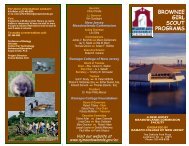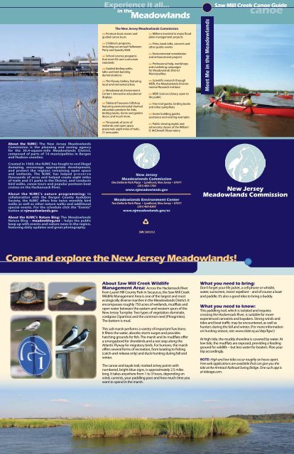
Come and explore the New Jersey Meadowlands!
Come and explore the New Jersey Meadowlands!
Come and explore the New Jersey Meadowlands!

Create successful ePaper yourself
Turn your PDF publications into a flip-book with our unique Google optimized e-Paper software.
About <strong>the</strong> NJMC: The <strong>New</strong> <strong>Jersey</strong> Meadowl<strong>and</strong>s<br />
Commission is <strong>the</strong> planning <strong>and</strong> zoning agency<br />
for <strong>the</strong> 30.4-square-mile Meadowl<strong>and</strong>s District,<br />
composed of parts of 14 municipalities in Bergen<br />
<strong>and</strong> Hudson counties.<br />
Created in 1969, <strong>the</strong> NJMC has fought to end illegal<br />
dumping, encourage appropriate development,<br />
<strong>and</strong> protect <strong>the</strong> regions remaining open space<br />
<strong>and</strong> wetl<strong>and</strong>s. The NJMC has helped preserve<br />
thous<strong>and</strong>s of acres <strong>and</strong> helped create eight miles<br />
of trails <strong>and</strong> 21 parks in <strong>the</strong> District, <strong>and</strong> conducts<br />
bird walks, canoe tours <strong>and</strong> popular pontoon boat<br />
cruises on <strong>the</strong> Hackensack River.<br />
About <strong>the</strong> NJMC’s nature programming: In<br />
collaboration with <strong>the</strong> Bergen County Audubon<br />
Society, <strong>the</strong> NJMC offers free twice monthly bird<br />
walks as well as o<strong>the</strong>r nature walks <strong>and</strong> additional<br />
special events. For <strong>the</strong> schedule click <strong>the</strong> “Events”<br />
button at njmeadowl<strong>and</strong>s.gov.<br />
About <strong>the</strong> NJMC’s Nature Blog: The Meadowl<strong>and</strong>s<br />
Nature Blog – meadowblog.net – helps <strong>the</strong> public<br />
keep up with events <strong>and</strong> nature news in <strong>the</strong> region,<br />
featuring daily updates <strong>and</strong> great photography.<br />
<strong>Come</strong> <strong>and</strong> <strong>explore</strong> <strong>the</strong> <strong>New</strong> <strong>Jersey</strong> Meadowl<strong>and</strong>s!<br />
1<br />
Experience it all...<br />
in <strong>the</strong><br />
Meadowl<strong>and</strong>s<br />
The <strong>New</strong> <strong>Jersey</strong> Meadowl<strong>and</strong>s Commission<br />
t Pontoon boat cruises <strong>and</strong><br />
guided canoe tours<br />
t Children’s programs,<br />
including our annual Halloween<br />
Party <strong>and</strong> Spooky Walk<br />
t School science programs<br />
that meet NJ core curriculum<br />
st<strong>and</strong>ards<br />
t Guided birding walks,<br />
talks <strong>and</strong> bird-b<strong>and</strong>ing<br />
demonstrations<br />
t The Flyway Gallery, featuring<br />
local environmental artists<br />
t Meadowl<strong>and</strong>s Environment<br />
Center’s interactive educational<br />
displays<br />
t Tidel<strong>and</strong> Treasures Giftshop<br />
featuring environmental <strong>the</strong>med<br />
education products for kids,<br />
birding books, home <strong>and</strong> garden<br />
decor, <strong>and</strong> much more.<br />
t Thous<strong>and</strong>s of acres of<br />
wetl<strong>and</strong>s <strong>and</strong> open space<br />
preserved, eight miles of trails,<br />
21 area parks<br />
<strong>New</strong> <strong>Jersey</strong><br />
Meadowl<strong>and</strong>s Commission<br />
One DeKorte Park Plaza • Lyndhurst, <strong>New</strong> <strong>Jersey</strong> • 07071<br />
(201) 460-1700<br />
www.njmeadowl<strong>and</strong>s.gov<br />
Meadowl<strong>and</strong>s Environment Center<br />
Two DeKorte Park Plaza • Lyndhurst, <strong>New</strong> <strong>Jersey</strong> • 07071<br />
(201) 460-8300<br />
www.njmeadowl<strong>and</strong>s.gov/ec<br />
J<br />
SMC 500 512<br />
t Millions invested in major flood<br />
plain management projects<br />
t Films, book talks, concerts <strong>and</strong><br />
o<strong>the</strong>r public events<br />
t Environmental remediation<br />
<strong>and</strong> enhancement projects<br />
t Professional help, workshops<br />
<strong>and</strong> marketing campaigns<br />
for Meadowl<strong>and</strong>s District<br />
Municipalities<br />
t Scientific research through<br />
MERI, <strong>the</strong> Meadowl<strong>and</strong>s Environmental<br />
Research Institute<br />
t MERI Science Library, open to<br />
<strong>the</strong> public<br />
t Free trail guides, birding books<br />
<strong>and</strong> o<strong>the</strong>r pamphlets<br />
t Green building guides,<br />
assistance <strong>and</strong> existing examples<br />
t Public viewing nights <strong>and</strong><br />
astronomy classes at <strong>the</strong> William<br />
D. McDowell Observatory<br />
About Saw Mill Creek Wildlife<br />
Management Area: Across <strong>the</strong> Hackensack River<br />
from Laurel Hill County Park in Secaucus, <strong>the</strong> Saw Mill Creek<br />
Wildlife Management Area is one of <strong>the</strong> largest <strong>and</strong> most<br />
ecologically diverse marshes in <strong>the</strong> Meadowl<strong>and</strong>s District. It<br />
encompasses roughly 750 acres of wetl<strong>and</strong>s, mudflats <strong>and</strong><br />
open water between <strong>the</strong> eastern <strong>and</strong> western spurs of <strong>the</strong><br />
<strong>New</strong> <strong>Jersey</strong> Turnpike. Two types of vegetation dominate,<br />
cordgrass (Spartina) <strong>and</strong> <strong>the</strong> common reed (Phragmites).<br />
The bottom is mud.<br />
This salt marsh performs a variety of important functions:<br />
It filters <strong>the</strong> water, absorbs storm surges <strong>and</strong> provides<br />
hatching grounds for fish. The marsh <strong>and</strong> its mudflats offer<br />
a smorgasbord for shorebirds <strong>and</strong> a rest stop along <strong>the</strong><br />
Atlantic Flyway for migratory birds. For humans, <strong>the</strong> marsh<br />
offers several forms of recreation, from boating to fishing<br />
(catch-<strong>and</strong>-release only) <strong>and</strong> duck-hunting during fall <strong>and</strong><br />
winter.<br />
The canoe <strong>and</strong> kayak trail, marked at key points with<br />
numbered, bright-blue signs, is approximately 2.5 miles<br />
long. It takes anywhere from 1 to 3 hours, depending on<br />
wind, currents, your paddling pace <strong>and</strong> how much time you<br />
want to spend in <strong>the</strong> marsh.<br />
Meet Me in <strong>the</strong> Meadowl<strong>and</strong>s<br />
Saw Mill Creek Canoe Guide<br />
canoe<br />
<strong>New</strong> <strong>Jersey</strong><br />
Meadowl<strong>and</strong>s Commission<br />
What you need to bring:<br />
Don’t forget your life jacket, a cell phone or whistle,<br />
water, sunscreen, insect repellant – <strong>and</strong> of course a boat<br />
<strong>and</strong> paddle. It’s also a good idea to bring a buddy.<br />
What you need to know:<br />
This paddling trail, which is isolated <strong>and</strong> requires<br />
crossing <strong>the</strong> Hackensack River, is suitable for moreexperienced<br />
canoeists <strong>and</strong> kayakers. Strong winds <strong>and</strong><br />
tides <strong>and</strong> boat traffic may be encountered, as well as<br />
hunters during <strong>the</strong> fall <strong>and</strong> winter. (For more information<br />
on hunting season, see: www.state.nj.us/dep/fgw/)<br />
At high tide, <strong>the</strong> muddy shoreline is covered by water. At<br />
low tide, <strong>the</strong> mudflats are exposed, providing a feeding<br />
ground for wildlife – but less water for boaters. Plan your<br />
trip accordingly.<br />
NOTE: High <strong>and</strong> low tides occur roughly six hours apart.<br />
Free web applications are available that can give you <strong>the</strong><br />
tide at <strong>the</strong> Amtrack Railroad Swing Bridge. One such app is<br />
at tideapp.com.
Saw Mill Creek Canoe Trail<br />
About <strong>the</strong><br />
Hackensack<br />
River<br />
The Hackensack River is<br />
roughly 50 miles long,<br />
beginning at Lake Lucille<br />
in Rockl<strong>and</strong> County, <strong>New</strong><br />
York, <strong>and</strong> filtering down<br />
to <strong>New</strong>ark Bay. The river<br />
is dammed just below <strong>the</strong><br />
Oradell Reservoir. Water<br />
south of <strong>the</strong> dam is brackish<br />
-- a combination of fresh<br />
<strong>and</strong> salt water.<br />
About Laurel<br />
Hill County Park<br />
The 100-acre Laurel Hill<br />
County Park in Secaucus,<br />
operated by Hudson<br />
County, offers great views<br />
of <strong>the</strong> Hackensack River <strong>and</strong><br />
<strong>the</strong> Saw Mill Creek Wildlife<br />
Management Area. There is<br />
a boat launch on your right<br />
– open dawn to dusk -- <strong>and</strong><br />
plenty of free parking. The<br />
park also includes lighted<br />
ball fields, an information<br />
kiosk <strong>and</strong> a river-front<br />
promenade that is part of<br />
<strong>the</strong> Secaucus Greenway.<br />
The large rock mass at <strong>the</strong><br />
sou<strong>the</strong>ast end of <strong>the</strong> park<br />
is what remains of Laurel<br />
Hill. Once much larger, <strong>the</strong><br />
rock was quarried until <strong>the</strong><br />
mid-2o th century. Colonists<br />
called <strong>the</strong> hill “Snake Hill”<br />
because of <strong>the</strong> many<br />
large black snakes found<br />
<strong>the</strong>re. According to local<br />
legend, <strong>the</strong> hill was also <strong>the</strong><br />
inspiration for Prudential<br />
Insurance’s “Piece of <strong>the</strong><br />
Rock” logo <strong>and</strong> slogan.<br />
The l<strong>and</strong> near <strong>the</strong> bottom<br />
of <strong>the</strong> hill once housed<br />
churches, several hospitals,<br />
a poor farm, an insane<br />
asylum <strong>and</strong> a school. Laurel<br />
Hill itself housed a prison.<br />
Today, those facilities are<br />
gone, <strong>and</strong> <strong>the</strong> park provides<br />
visitors a chance to enjoy<br />
<strong>the</strong> Hackensack River <strong>and</strong><br />
<strong>the</strong> surrounding marshl<strong>and</strong>.<br />
Saw Mill Creek<br />
Paddling Trail<br />
Start: The best starting point<br />
for <strong>the</strong> paddling trail is <strong>the</strong><br />
boat launch at Laurel Hill<br />
County Park, just across <strong>the</strong><br />
river from <strong>the</strong> marsh. Cross<br />
<strong>the</strong> river carefully, watching<br />
for currents <strong>and</strong> boat traffic,<br />
<strong>and</strong> head for <strong>the</strong> bright blue<br />
marker at <strong>the</strong> trail entrance.<br />
(Paddling becomes easier<br />
once you enter <strong>the</strong> trail.)<br />
At <strong>the</strong> First Marker you enter<br />
<strong>the</strong> man-made channel – a<br />
ditch dug by <strong>the</strong> old Civilian<br />
Conservation Corps – <strong>the</strong><br />
Manhattan skyline is behind<br />
you, to <strong>the</strong> east, <strong>and</strong> <strong>the</strong> ridge<br />
line ahead to <strong>the</strong> west is<br />
North Arlington.<br />
MUDFLAT<br />
About <strong>the</strong> Marsh<br />
The marsh, part of <strong>the</strong> Hackensack<br />
River estuary, was closed off from<br />
<strong>the</strong> river’s tidal flow with dikes<br />
<strong>and</strong> tide gates starting in <strong>the</strong><br />
1820s. This effort to drain <strong>and</strong><br />
dry out <strong>the</strong> marsh continued for<br />
nearly 100 years, through work<br />
by <strong>the</strong> Bergen County Mosquito<br />
Commission <strong>and</strong> o<strong>the</strong>rs, <strong>and</strong><br />
resulted in <strong>the</strong> invasion of <strong>the</strong><br />
common reed (Phragmites).<br />
In 1950, a huge November<br />
storm struck <strong>the</strong> area, destroying<br />
<strong>the</strong> dikes <strong>and</strong> tide gates <strong>and</strong><br />
reopening <strong>the</strong> marsh to tidal flow<br />
from <strong>the</strong> Hackensack. As a result,<br />
<strong>the</strong> conditions changed again,<br />
<strong>and</strong> native cordgrass (Spartina)<br />
began to replace <strong>the</strong> Phragmites<br />
that had come to dominate <strong>the</strong><br />
area. The area is now regaining its<br />
function as a healthy salt marsh,<br />
filtering <strong>the</strong> water <strong>and</strong> providing<br />
food <strong>and</strong> habitat for a variety of<br />
wildlife.<br />
2<br />
Move quietly as you paddle<br />
along <strong>the</strong> channel, so as<br />
not to scare off wildlife, <strong>and</strong><br />
watch <strong>the</strong> muddy banks for<br />
herons, egrets, Diamondback<br />
Terrapins, Fiddler Crabs, small<br />
s<strong>and</strong>pipers <strong>and</strong> yellowlegs in<br />
summer.<br />
At <strong>the</strong> Second Marker<br />
<strong>the</strong> marsh opens up into a<br />
mudflat <strong>and</strong> <strong>the</strong> straight,<br />
man-made channel meets a<br />
wider natural waterway. Turn<br />
left <strong>and</strong> paddle south, along<br />
<strong>the</strong> original Saw Mill Creek<br />
Channel.<br />
As you follow Saw Mill Creek,<br />
you can see a huge grassy hill<br />
– a closed l<strong>and</strong>fill – <strong>and</strong> <strong>the</strong><br />
<strong>New</strong> <strong>Jersey</strong> Turnpike on your<br />
right. At one point, this l<strong>and</strong>fill<br />
was slated to extend all <strong>the</strong><br />
way to <strong>the</strong> Hackensack River,<br />
<strong>and</strong> to fill all <strong>the</strong> wetl<strong>and</strong>s<br />
SPARTINA MARSH<br />
SPARTINA MARSH<br />
LOW MARSH<br />
TIDE<br />
GATE<br />
3<br />
in between, including Saw<br />
Mill. The Meadowl<strong>and</strong>s<br />
Commission went to court<br />
to stop this plan <strong>and</strong> was<br />
successful in protecting <strong>the</strong>se<br />
wetl<strong>and</strong>s. When <strong>the</strong> tide is<br />
high enough, you can <strong>explore</strong><br />
<strong>the</strong> side channels into <strong>the</strong><br />
marsh along this section of<br />
<strong>the</strong> paddling trail.<br />
As <strong>the</strong> trail bends slightly to<br />
<strong>the</strong> east, you can see Kearny<br />
<strong>and</strong> <strong>New</strong>ark up ahead. This<br />
view gives you a good idea<br />
of how urban <strong>and</strong> industrial<br />
areas surround <strong>the</strong> lower part<br />
of <strong>the</strong> Hackensack River.<br />
When <strong>the</strong> tide is low, keep<br />
your eyes peeled for <strong>the</strong><br />
ribbed mussels that live in <strong>the</strong><br />
mud. Often hidden by <strong>the</strong>ir<br />
tangled root mass, <strong>the</strong>se twoinch-long<br />
filter-feeders help<br />
clean <strong>the</strong> water. You may also<br />
see little grass shrimp, about<br />
an inch long, that also feed<br />
on plant detritus. And if you<br />
bring your fishing pole,<br />
you might be able to<br />
hook a striper, white<br />
perch or bluefish along<br />
this section. (Fishing is<br />
catch <strong>and</strong> release only.)<br />
OSPREY<br />
PLATFORM<br />
Canoe Trail - 2.2 miles<br />
Start <strong>and</strong> End Point<br />
NJMC websites:<br />
Our home page: njmeadowl<strong>and</strong>s.gov<br />
Our research arm: meri.njmeadowl<strong>and</strong>s.gov<br />
Our nature blog: meadowblog.net<br />
Our history blog: meadowpast.net<br />
1<br />
HACKENSACK RIVER<br />
LAUREL HILL<br />
COUNTY PARK<br />
LAUREL HILL<br />
CANOE LAUNCH<br />
SECAUCUS, NJ<br />
As you approach <strong>the</strong><br />
Hackensack River again, look<br />
up in <strong>the</strong> sky for Ospreys. They<br />
have been nesting by <strong>the</strong><br />
railroad bridges downstream<br />
<strong>and</strong> like to fish in <strong>the</strong> open<br />
water nearby.<br />
The Portal Bridge, visible<br />
to <strong>the</strong> south, was built in<br />
1907 <strong>and</strong> is <strong>the</strong> largest on<br />
<strong>the</strong> Nor<strong>the</strong>ast Corridor rail<br />
line <strong>and</strong> <strong>the</strong> only remaining<br />
center-bearing swing bridge<br />
of <strong>the</strong> three constructed.<br />
At <strong>the</strong> Third Marker,<br />
congratulations, you have<br />
reached <strong>the</strong> end of <strong>the</strong><br />
paddling trail. The boat<br />
launch is just across <strong>the</strong> river<br />
to <strong>the</strong> north, in Laurel Hill<br />
Park. Use caution as you<br />
make your way across, <strong>and</strong><br />
check <strong>the</strong> shoreline on your<br />
left for <strong>the</strong> remains of <strong>the</strong> old<br />
tide gates from <strong>the</strong> 1950s.<br />
Cormorants often perch on<br />
<strong>the</strong>se wooden structures to<br />
dry <strong>the</strong>ir wings.<br />
<strong>New</strong> <strong>Jersey</strong> Meadowl<strong>and</strong>s Commission<br />
One DeKorte Park Plaza t Lyndhurst, NJ t 07071 t 201-460-1700 t www.njmeadowl<strong>and</strong>s.gov