Woodneath Master Plan2.indd - Mid-Continent Public Library
Woodneath Master Plan2.indd - Mid-Continent Public Library
Woodneath Master Plan2.indd - Mid-Continent Public Library
- No tags were found...

Create successful ePaper yourself
Turn your PDF publications into a flip-book with our unique Google optimized e-Paper software.
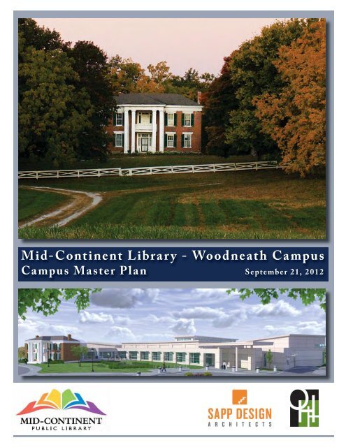
<strong>Mid</strong>-<strong>Continent</strong> <strong>Library</strong> - <strong>Woodneath</strong> CampusCampus <strong>Master</strong> Plan September 21, 20121
Table of ContentsAcknowledgementsIt is with great thanks that we present the new <strong>Master</strong> Plan for the <strong>Woodneath</strong> Branch of the <strong>Mid</strong>-<strong>Continent</strong><strong>Public</strong> <strong>Library</strong>. The hard work of the Board of Directors, the Administration, the <strong>Library</strong> Staff, City and CountyRepresentatives, and additional Community Members have made this plan better than it would have beenotherwise. We hope their hard work and dedication to make <strong>Woodneath</strong> an incubator of learning and knowledgeis reflected in the Plan.Ken Boone, DirectorShannon Gordon, Senior Project ManagerPlan Prepared By:In Association With:2
Table of Contents1.0 Introduction & Purpose 42.0 History and Background 83.0 Site Inventory & Analysis 104.0 Visioning & Stakeholder Process 245.0 <strong>Master</strong> Plan 366.0 Budget & Phasing 44Appendix A - Site Analysis and <strong>Master</strong> Plan Graphics3
Section 1.0Introduction & Purpose<strong>Woodneath</strong> Homestead Birds EyeA bird’s eye view of the <strong>Woodneath</strong> property circa pre November 20111.1 - IntroductionThis document represents the culmination ofan inclusive collaboration process between theBoard of Directors, Administration, <strong>Library</strong> Staff,Representatives from KCMO, Representatives fromClay County, MARC, and additional CommunityMembers for developing a new Community <strong>Master</strong>Plan for the <strong>Woodneath</strong> Branch of the <strong>Mid</strong>-<strong>Continent</strong> <strong>Public</strong> <strong>Library</strong>. This Document willdefine the Purpose of the Plan (Section 1), TheHistory of the Site (Section 2), The Inventory andSite Analysis of the Campus (Section 3), The <strong>Master</strong>Plan Stakeholder Process (Section 4), The <strong>Master</strong>4Plan (Section 5), The Implementation Plan (Section6) and, finally, large scale maps of the plan (Section7).1.2 - <strong>Mid</strong>-<strong>Continent</strong> <strong>Public</strong> <strong>Library</strong>Mission<strong>Mid</strong> <strong>Continent</strong> <strong>Public</strong> <strong>Library</strong> serves one of thelargest political subdivisions in Missouri, with over750,000 people. The library lends over 9 millionprint and digital items each year, including books,eBooks, audiobooks, DVDs and CDs. MCPLprovides access through 30 physical branches,4-co-located branches, and a virtual library. It alsoprovides access to more online content than everyother public library in Missouri combined. MCPLis dedicated to serving its customers and providinga stimulating environment for learning as stated intheir Mission Statement:
Mission Statement:MCPL will provide exceptional customer service andexpanding access to materials, programs and technologyincluding a World Class Genealogy and Family History<strong>Library</strong>.We will accomplish our mission by:-Providing opportunities for life-long learning andexploration in comfortable, stimulating, safe andconvenient settings.-Ensuring the highest quality customer service staff tomeet the wants and needs of diverse populations.-Ensuring the long term fi nancial sustainability of thelibrary.1.3 - PurposeIn keeping with their mission, MCPL is currently inthe process of constructing a new library branch inthe fast-growing Shoal Creek area of Kansas City. Thesite for the new library branch is located on a 32 acreparcel of land just west of Liberty, MO. The LibertyBranch has recently become the most frequentedbranch in the entire MCPL system. Anticipatingthis growth in the northland to continue, MCPL isconstructing the new <strong>Woodneath</strong> branch that willbe the most technologically advanced in the MCPLsystem.The purpose of this plan is to chart a course forthe next 20 years of site development at MCPL’s<strong>Woodneath</strong> Branch. It will review, defi ne and analyzesite conditions, and propose a 20 year developmentplan for facilities, circulation, parking, open-space,historical/ cultural/ archeological importance,learning, teaching, and storytelling areas. It willalso provide initial budgets, and phasing.5
Introduction & Purpose1.4 – Why Develop a <strong>Master</strong> PlanSo why develop a <strong>Master</strong> Plan? Any successfulfacility, campus, development or organization needsan articulated vision and a plan to implement thatvision. A <strong>Master</strong> Plan is that guide. Because ofthe financial impact of the ongoing costs of facilitiesand maintenance, the continuing acceleration ofcapital costs for new facilities and the difficulty ofsuccessfully operating any venture in fast-paced,complicated and difficult times, a well defined planwith measurable outcomes is required for success.This Plan is the road map for the future developmentof the property based on a stakeholder driven<strong>Master</strong> Plan process. More importantly it is a toolthat can be constantly referenced to help inform,guide and direct the decision making process asimplementation of the Plan moves forward.1.6 – Maintaining the <strong>Library</strong> <strong>Master</strong>PlanSince the <strong>Master</strong> Plan is a “living document,”keeping it up-to-date and accurate will ensure itscontinued usefulness. Therefore, it will becomenecessary to revise it as mission, budget, standardsand other conditions generate new planningand design requirements in response to programchanges and facility needs. Variations of this plancan and will likely happen. It is intended to helpdefine the general direction of the campus alongwith logical steps to develop. It is not intendedto be the end of the planning and design on thecampus, but rather the beginning.It is also important to understand the ‘lens’ throughwhich the <strong>Master</strong> Plan should be viewed. The <strong>Master</strong>Plan is a high-level stragtegic document that focuses onthe general idea, and not the detail. For example, we mayknow that because of views, proximity, shade, and access,a spot along the trail system would be great for a stoppingpoint. We don’t know what the design elements of thatstopping point are (benches, picnic table, council ring,paving, lighting, etc), but we know we have an area thatelements will go into that supports the overall goals of theproject. ‘Filling in the blanks’ will come later during thenormal design development phases, as will fine tuningof costs. This high level approach allows us to not befocused on detail yet and focus on the making sure thebigger picture is correct first.1.5 – <strong>Master</strong> Plan ObjectivesThe objectives of the <strong>Master</strong> Plan will provide thefollowing: a set of general layouts, improvements andrenovations that supports MCPL’s mission; guidance foraccomplishing the mission through sustainable practices;a structured methodology for establishing projects toimprove the visual imagery of the campus; and an ideafor the phasing of those improvements.6
Introduction & Purpose1.7 – AudienceThis <strong>Master</strong> Plan Document is to be used by allindividuals involved in short and long term decisionmaking of design, construction and maintenance offacilities. The primary users include the following:• MCPL Director• MCPL Board• MCPL Staff and Volunteers• MCPL Facility MaintenancePersonnelThe ultimate success of the <strong>Master</strong> Plan is dependentupon the commitment of these individuals workingas a team to implement the vision laid out in thisdocument.1.8 – Naming Conventions in thisDocumentOver the course of its existence, the property hasbeen owned by multiple residents and referred to bymany different names: Elbridge Arnold Homestead,Edwin Crouch Residence, Crouch Dairy Farm,<strong>Woodneath</strong>, and now <strong>Mid</strong>-<strong>Continent</strong> <strong>Public</strong><strong>Library</strong> – <strong>Woodneath</strong> Campus. In this document,these names are used interchangeably and all referto the same property. It is important to note thatthe new name for the property and its function isthe <strong>Mid</strong>-<strong>Continent</strong> <strong>Public</strong> <strong>Library</strong> – <strong>Woodneath</strong>Branch. ction is ‘The Drumm Farm Center forChildren’.AudienceThe design team conversing with a group of stakeholders at a meeting in August, 20127
Section 2.0<strong>Woodneath</strong> HistoryHistoric <strong>Woodneath</strong>A photo of the historic residence circa 1976 while it was owned by the Crouch Family2.1 –<strong>Woodneath</strong> History“<strong>Woodneath</strong>” has had a varied past over its 150plus years of existence. The original residence wasconstructed in 1855-56 as a two-story, five bay,L-shaped building and was the home for farmerand landowner Elbridge Arnold. The residenceis one of the oldest antebellum structures inKansas City and remains an important survivingexample of a brick, Greek Revival style farmhouse.During construction of the house, Mr. Arnoldpassed away and his widow Finetta Ann Arnoldwas left to finish the home, with the help of somelocal carpenters and slave labor. The home hasalways been used as a residence, except during theCivil War, when the west second story bedroomwas utilized as school room by Arnold’s eldestdaughter, Sara M. Arnold. The term “<strong>Woodneath</strong>”is thought to come from the setting of the ofthe residence and outbuilding in the woodedarea surrounding the property and named byOwner Presley Moore (1870-1900). Over theyears, the farm has produced hemp, corn and8
hay, and manufactured brick from rich claydeposits. During the period between 1937-1953,the owner (Edwin Crouch) used the property as aDairy Farm. In the recent past the land has beensharecropped, and just within the last couple ofyears the Crouch family had sold the land to <strong>Mid</strong>-<strong>Continent</strong> <strong>Public</strong> <strong>Library</strong>.2.2 – Present-UseToday, the campus is known as the <strong>Mid</strong>-<strong>Continent</strong><strong>Library</strong> - <strong>Woodneath</strong> Branch. It will be one ofthe most technologically advanced public librariesin the region and be a gem for the community formany years to come.<strong>Woodneath</strong>Additional Photographs fromthe property in 1976.9
Section 3.0Site Inventory & AnalysisSite Inventory and Analysis - Inventory of Existing Conditions3.1 - Site InventoryBefore any design work was conducted, the OHH/Sapp Design Associates Team of planners, architects,and landscape architects researched the history of<strong>Woodneath</strong> and conducted numerous site visits.OHH gathered existing surveys, utility information,newspaper articles and photographs. In order togain a better understanding of <strong>Woodneath</strong>’s pastand current conditions, a detailed site inventory wasconducted. The following is a written summary ofthe architectural, archeological, cultural, social andnatural systems inventory.3.1.1 - Current Location and PropertyThe <strong>Mid</strong>-<strong>Continent</strong> <strong>Public</strong> <strong>Library</strong> <strong>Woodneath</strong>Branch is comprised of just under 32 acres of landin the northland. It is located about 15 milesnortheast of downtown Kansas City and just westof Liberty. Even though it is within the city limitsand surrounded by development, it still retainsopen space characteristics of a rural development.Of the 32 acres of land, approximately 20% of itis built upon and developed as the original house,new library, and associated parking. The rest ofthe landscape remains as rolling open fields andan ephemeral stream corridor that physically andvisually divides the site into an east and west half.MCPL <strong>Woodneath</strong> Branch’s legal description T51N,R 33W, Sec. 2, SW ½ and the mailing address is:8900 N.E. Flintlock RoadKansas City, MO 6415710
Though once much larger, <strong>Woodneath</strong> is now boundedby single family residential homes on the east andwest, apartment housing to the south, and ShoalCreek Elementary school to the north. Most of thesurrounding land was once part of the original 160 acreArnold, Elbridge (<strong>Woodneath</strong>) Homestead and waspreviously used for agricultural purposes.3.1.2 - Background and Landmark StatusAs stated previously, the original residence wasconstructed in 1855-56 as a two-story, five bay, L-shapedbuilding and was the home for farmer and landownerElbridge Arnold. Because if its age, architectural style,and history, the home as well as the associated land isimportant.only property in the Northland that is on the city,county, state, and federal landmarks registers. Thehome is also considered to be an excellent exampleof a rural farmhouse built in the Greek RevivalStyle. It is a 2 and one-half story farmhouse withan uncoursed native limestone foundation and acoursed limestone water table extending along theground story of the exterior. The walls consistof 18” thick hand-made bricks and the entrancesurrounds, porch elements and frame addition arepainted white. A two-story portico adorns the eastfaçade and is composed of white columns and twopilasters supporting the hipped roof. There are 3,single stack, red brick chimneys located throughoutthe home. Over the years, many alterations to thehome have taken place:In February of 1977, the Kansas City LandmarksCommission declared the Arnold, Elbridge Residenceand 26.5 acres of the site to be of Landmark Status andincluded on the National Register. The property wasselected to the National Register of Historic Places asan example of the themes of “Agriculture, Architecture,Exploration and Settlement, and Society.” Landmarkstatus includes both the original residence as well as thesurrounding landscape.3.1.3 Building Use and Current ConditionsThere are currently 5 permanent buildings on site thathave been built over the span of nearly 160 years as wellas 1 permanent structure currently under construction.The historic Elbridge Arnold residence is the oldest ofthe structures and was completed in 1856. This is the11
Site Inventory & Analysis1. 1880 – Installation of door connectingfront and rear upstairs2. 1901- Installation of wood-burningfurnace, brick cistern, and addition of southfacadeporch3. 1910- Addition of kitchen on the first floorand acetylene light system4. 1917-1922 – Installation of kitchencabinets5. 1922- Removal of observatory6. 1931- Installation of electricity7. 1938 – Kitchen moved to present location8. 1940 – Residence painted and reshingled,kitchen linoleum laid9. 1940’s – Basement floor converted fromdirt to concrete10. 1945 – Installation of two full bathroomsand water system11. 1958 – Dining room replastered and newwindows along south wall12. 1964 – Two rooms west of the kitchen areadded13. 1965 – Two rooms west of the kitchen areremoved and replaced with a porch and portecochere14. Currently – Full renovation of the hometo serve as support space for the public libraryaddition. The will operate as a writing lab andself-publishing center, while the second floorwill contain media labs.Historic Elbridge Arnold ResidenceYear Constructed:1855-1856Current Use 2012:Currently being renovatedto serve as a writing andmedia lab for the libraryadditionYear Constructed:A public library is currently under constructionon-site that will constitute a major addition tothe <strong>Woodneath</strong> homestead. The library willbalance historical interests and modern needsof its customers. The new library will be themost advanced in the MCPL system with newtechnology incorporated into the building andadjacent outdoor public space. The architectshave been working closely with the Kansas CityLandmarks Commission during the planningprocess in order to retain the character of the siteand determine materials of the building. The newaddition will be a one-story spanning addition thatwill provide meeting rooms, a young adult andchildren’s area, a computer lab, and main collectionarea. MCPL intends for the building to meetLEED specifications.MCPC <strong>Woodneath</strong> Branch <strong>Library</strong>Construction Start Date:November 28, 2011Year Constructed:Still Under Construction12
Site Inventory & AnalysisThere had been two single story cottages locatedsouthwest of the residence. One of the cottages hasbeen torn down or had fallen down at some pointin the past and only the foundation remains. Thewood frame cottages were constructed in the early1940’s. The remaining cottage is overgrown withshrubs and looks to have substantial roof damage.Single Story CottagesYear Constructed: 1940-9142Current Use 2012: VacantA 4-bay stable structure/machine shed is locatedimmediately west of the barn. The wood structureis painted white and has a corrugated steel roof.A large, broken concrete pad is located along thesouth side of the structure.4-Bay Stable Structure (Machine Shed)Year Constructed: UnknownCurrent Use 2012: VacantA wood frame, white painted outbuilding, once used tohouse bulls is located just west of the stream corridorand is currently is poor shape. The structure is leaningto the east and a portion of the roof has failed.Immediately surrounding the structure is a barbedwire fence. A stormwater drainage area is situated justto the south of the structure.A large 2 story barn with lofted storage space sits justeast of the stables. The barn is currently overgrownand camouflaged by adjacent trees and vine growth.The structure is structurally unsound with the rooffailing and holes in the floor. Bottom story entranceis from the east side, while second story access isgained from the west. The original barn (locatedjust west of the home) was constructed in 1875 andwas torn down at some point in the past.Bull BarnYear Constructed:UnknownCurrent Use 2012:VacantWood Frame BarnYear Constructed:UnkownCurrent Use 2012:Vacant13
Site Inventory & AnalysisDirectly north of the stables and barn is anapproximately 60’ tall vitrified red brick silo. Thesilo has a concrete base and is missing a roof. Thesilo is currently surrounded by thick trees andvegetation. It looks to be structurally stable, butit is recommended that a professional performs anstructural assessment of the structure.SiloYear Constructed:1920’sCurrent Use 2012:UnusedAdditional Historic StructuresThere are at least three additional structures thatwere once located on site and have been previouslyremoved. Just north of the residence was a chickenhouse, ice house, and the original barn location. Thechicken house was torn down with permission fromthe Landmarks Commission during constructionof the library. The foundation of the ice house isstill intact. The library has been working with anarcheologist to determine if there are any othercultural areas/artifacts such as cemeteries on site. Atthis point in time, the archaeologist has only foundevidence of typical homestead operations. He hasidentified a location southwest of the residencewhere clay was removed for brick production as wellas an area just south of the residence where the firingof bricks likely occurred.14
Site Inventory & Analysis3.1.4 - Existing On-Site Land UseThere have been no farming activities on theproperty since the land was sold to <strong>Mid</strong>-<strong>Continent</strong><strong>Public</strong> <strong>Library</strong> a few years ago and planning andconstruction had started on the new library. Initiallythe homestead was a working farm that producedhemp, corn, hay, and manufactured brick. In the1970’s the homestead was used as a dairy farm,and in recent years had been share cropped. Thenew library addition and associated parking willbe located on the east side of the creek adjacent tothe historic residence. Native vegetation restorationareas are planned to buffer the parking lot and alongthe southern side of the home. Numerous stormwaterBMPs are positioned on the eastern side of the creekto slow, capture, and cleanse stormwater.The west side of the stream corridor is traditionallywhere the operational farming occurred. Thisis where the silo, barn and stables are located.Currently, there is no defined land use for this sideof the property and it remains as open semi-woodedfields.3.1.5 - Landmark StatusAs stated previously, <strong>Woodneath</strong> Homestead is theonly property in the Northland that is on the city,county, state, and federal landmarks registers. Thelandmark status not only pertains to the residencestructure, but to the landscape itself. Just over 26 ½acres of the 30-32 acre site is considered “landmark.”Because of its status, any changes/improvementsto the landscape must follow the City’s HistoricPreservation Code, which is based off of the Secretaryof the Interior’s Standards for Rehabilitation.Standards that effect the landscape include-A property will be used as it was historicallyor be given a new use that requires minimalchange to its distinctive materials, features,spaces, and spatial relationships.-The historic character of a property willbe retained and preserved. The removalof distinctive materials or alteration offeatures, spaces, and spatial relationships thatcharacterize a property will be avoided.-Archaeological resources will be protectedand preserved in place. If such resources mustbe disturbed , mitigation measures will beundertakenFuture work on-site must be coordinated with thelandmarks commission.15
Site Inventory & Analysis16
Site Inventory & Analysis17
Site Inventory & Analysis3.1.6 - CirculationRegional access from Kansas City to the site occursfrom I-35 to Highway 152 to Flintlock Road.Once in close proximity, vehicular access into thesite occurs off of NE Flintlock Road or from NE90th Street. Historically, the site was accessedfrom a narrow drive that headed west from a midblockaccess road off of Flintlock between NE 90thand NE 88th. This entrance is being maintainedand enhanced to provide a front door entry to thelibrary and renovated residence. The additionalentrance off of NE 90th St. provides access to themain parking area. Directly south of the residenceis an additional drop-off area and smaller parkingarea. There is also an old concrete access road thatspans from the smaller parking lot, west towards thestream corridor, then south towards the remainingcottage.Pedestrian circulation on campus is limited tosidewalks immediately surrounding the new libraryand pedestrian connection to the sidewalks/trailsthat run along Flintlock Road and NE 90th St.Currently, there is only one stream crossing thatconnects the east and west sides of the creek. It isa vehicular grade low water crossing that connectsthe stables/barn, with the home. There is a windingtrail around a small pond just west of the site, aswell as a sidewalk within the apartment complexto the south that gets close to the property line atnumerous locations.183.1.7 - Existing Utility InformationExisting utility information serving <strong>Woodneath</strong>was conducted prior to the architectural planningand design of the library addition. Additionalinformation was gathered from historical data, cityrecords, and visual inspection.- Electricity is currently supplied to the sitevia overhead power lines. The lines enter theproperty at the southeast corner of the site andrun northwest to the <strong>Woodneath</strong> residence.At this point, the line splits and one line headssouthwest towards the remaining cottage,while the other crosses the stream corridor andheads towards the barn. All electric lines onthe property are in the process of being buriedwith the new library construction.- A natural gas line runs parallel on the northside of the Flintlock Rd. entrance towards theround-a-bout. At that point, it cuts across themain parking lot towards the library servicearea on the north end of the building. Thegas lines will be shut off/abandoned duringlibrary construction. The future library andrenovated home will be all electric.- The main sanitary sewer line follows thestream corridor and runs north and south.There is a leg that T-s into the system from theadjacent neighborhood clubhouse/pool andfrom the library addition.- Stormwater on site is predominatelymanaged through a series of stomwaterretention/detention basins. A storm sewerline runs from the stormwater bmp on theeast side of the library south, connecting withanother line from the bmp to the northeast ofthe entry round-a-bout. The line then runssouthwest towards a larger retention area.Excess stormwater is directed to the ephemeralstream.- Domestic water is provided from the main
Site Inventory & Analysisthat runs parallel to Flintlock Road. Theservice line runs from the north side of thelibrary addition, across the main parking lot,then runs parallel to the entry drive beforeconnecting to the main.-There are a variety of different fencing typeson site. An ornamental PVC fence runs alongthe perimeter of the property on the FlintlockRd. side and along NE 90th Street. A barbedwire fence as well as thick vegetation definesthe southern edge of the property line. Thereare additional barbed wire fences around thebarn, stables, and farm outbuilding.3.1.8 - Existing VegetationMost of the site is made up of rolling topographywith tall grass savannah vegetation mixed withdeciduous woods along the stream corridor,northwest and southwest edges. There are a fewlarge specimen trees that provide focal points fromdifferent areas on site. There is a large bur oakatop the ridge running along Flintlock Road thatis visible from most places on-site. The majority oftrees on campus are large overstory trees that areapproximately 80-100 years old. Unfortunately,some of the trees near the residence were unableto be saved during library construction and wererecently harvested. A local carpenter is usingthe wood to produce wooden furniture. Most ofthe remaining trees are varieties of oak, walnut,hickory, coffee tree and hackberry. The proposedlandscape plan for the library incorporatesplantings that are appropriate with its landmarkstatus. The plan calls for maples, birches, walnuts,tulip trees, sycamores and oaks as well as cedarsand dogwoods to be planted along the perimeterand within the parking areas.19
Site Inventory & Analysis3.1.9 - Existing WildlifeDuring a site visit in late July, multiple different types of wildlife were observedon-site that would be considered common to the area. During the site visit,the grass was about 3-3 ½ feet tall and hadn’t been mowed in a while. In thattall grass were a number of grass hoppers, honeybees and butterfl ies. In theshorter grass areas around the barn there were a number of lizards present.There were also many unidentified small birds flying around, as well as ahawk and a large barn owl. Though not seen that day, it is estimated thatthere are approximately 10 deer that live on site (including 2 bucks).3.1.10 - MicroclimatesMicroclimates are localized zones where the climate differs slightly orsignificantly from the surrounding area. Microclimates can be as small asa couple of feet, like the north side of a building, or as large as a couple ofsquare miles, like the heat island effect in an urban area. One way to easilyidentify microclimates is by documenting and analyzing shade patterns.This can easily be done by examining slope aspect, mass/void diagrams, byutilizing more complex 3-D modeling software.Mass/Void andExisting VegetationStudyUsed to quicklyvisualize vegetationmassing and coveras well as structurelocationsSlope AnalysisUsed to map areas ofsteep grade change thatmay create limitationsfor accessibility andconstructionCooler microclimates are located below trees and on the north andnortheast sides of buildings. Seating areas should be positioned in theseareas to take advantage of the cooler ambient temperatures. Conversely,areas exposed to southwest sun, like the southwest side of the library are notdesirable locations for seating. Shade structures or overstory trees should beplanted to provide shade in these areas and to promote habitable conditions.In the winter, the northeast sides of buildings receive limited sun and aresusceptible to ice accumulation. Special attention should be paid to theseareas in the winter to limit icy conditions.Plant material is also affected by microclimates. Drought tolerant speciesshould be planted on the southwest sides of buildings because they musttolerate the warmer temperatures and radiated heat from the buildings.Conversely, plants on the north side of buildings are exposed to desiccatingwinds and should be tolerant of cool winter winds.Solar Aspect StudyUsed to mapmicroclimateconditions basedon solar aspectcharacteristics20
Site Inventory & Analysis3.1.11 - Soil MappingAccording to the NRCS Web Soil Survey, thereare 5 distinct soil types that are found on the 32acre site. Soil types are differentiated by physical,chemical, and biological characteristics such astexture, structure, density, PH and organic matter.Most of the soils on site consist of SharpsburgLoam 2-5% and Nodaway Loam 0-2%. TheSharpsburg Loam is predominately located inuplands and hillsides while the Nodaway Loam islocated along the waterways and throughout thefloodplain.According to NRCS, the Sharpsburg loam issomewhat limited for construction of structureswith basements due to its high shrink swellproperties, and the Nodaway soils are very limiteddue to susceptibility to flooding. All soil typesare very limited for road and street constructionbecause of low strength, frost action, depth tosaturation zone, or high shrink swell. Beforeany additional construction occurs on site, it isrecommended that a detailed soil report is preparedand that soil preparation recommendations arefollowed.3.1.12 - Slopes and TopographySlopes throughout the property are consistent in itsrolling nature. A berm runs north and south alongFlintlock Road, south of the main entry. Recentgrading in this area has opened up a portion, justnorth of the large bur oak, where people in vehiclescan catch a glimpse of the library as they are drivingby. Between Flintlock Rd. and the main parkingarea, a large bowl is present and directs water to aseries of detention areas. Steep grades are positionedoff the west side of the library and will pose challengesin meeting ADA access for walks and trails. Thereare also some steep grades along the stream corridorand wooded areas to the south.Shade Study - 8am Shade Study - Noon Shade Study - 5pmShade Study - Used to assist in determining areas that may experience microclimate conditions21
Site Inventory & Analysis3.2 - Site AnalysisDuring the site inventory and analysis stage, the design team gained anintimate knowledge of <strong>Woodneath</strong> and its surrounding context. Throughthis process the team developed an analysis from existing conditions anddrew conclusions regarding both physical and social opportunities andconstraints.Below are some of the overarching opportunities that were derived fromthis process:Soil CharacteristicsAnalysisUsed to visualizedifferent soil types anddetermine limitationsfor the construction ofroads and structures1. The existing site entry locations off of Flintlock Rd. and NE 90th St.present an opportunity to provide a desirable first impression with entrysignage, strategic vegetation placement, or directed views.2. Proposed plant massings along the perimeter of the site pose achallenge in that they do not reflect the historic nature of the landscape.New solutions should be examined to relate to the historic landmarklandscape.3. A number of stormwater BMPs exist on site and provide anopportunity to educate library customers about stormwater run-off, raingardens, native plants, and wildlife.4. The east and northeast side of the library expansion provide afternoonshade and will create a nice microclimate for an outdoor reading garden orentry plaza.5. The area directly west of the library, overlooking the creek, is adesirable location for an outdoor learning garden. This spot would alsobe a good location for an amphitheater that would take advantage of theexisting grade change and its close proximity to the library.6. An old hen house, ice house and the original barn once stood wherethe new library is being constructed. There is an opportunity to provide amarker or signage within the library to educate library customers of whatwas once located where they are standing/reading.7. The existing cottage, barn and stables are historically importantstructures but are unsafe and would be extremely expensive to renovate.These structures will probably have to be removed in the near future.There is an opportunity to provide a replacement structure/shelter at oneor all of these locations using reclaimed materials from the structures.8. The existing concrete drive and low water bridge connecting the eastand west sides of the property is in poor condition and should be removedor replaced.22
Site Inventory & Analysis9. There is a large relatively flat area of land on thewest side that receives good sun exposure. Thisarea could be used for an educational garden or forvegetable production if desired.10. The ephemeral stream poses a challengebecause it physically separates the site into an eastand west side. The existing stream crossing shouldbe enhanced to provide access during times of highwater flow. There is an opportunity to strategicallythin some vegetation and direct views to and fromthe rear of the library.11. The adjacent trail to the west of the propertypresents an opportunity to provide a pedestrianentry point to the site. This also poses securitychallenges if the library is trying to limit access tothe west half of the property.12. The existing vitrified red brick silo looks to bestructurally sound. There may be an opportunityto cost effectively renovate the silo and transform itinto a tower or overlook.13. With some minor grading adjustments, theopen field to the south of the library and entrydrive could potentially be used for overflowparking.14. This same area is naturally graded for anoutdoor amphitheater. This would also be a goodlocation to incorporate some sort of outdoorperformance or classroom space.15. Once the library construction is completed,pedestrians will potentially cut through the woodsfrom the apartment complex to the south. Thereis a challenge to control access at this point, or anopportunity to provide a pedestrian entrance/trailat this location.16. The area north of the barn if full of thickvegetation and acts as a visual screen to theneighborhood pool to the northwest. There is anopportunity to clear some of this thick vegetationand incorporate a nature trail that cuts throughthis area.17. Kansas City, Missouri has a stream protectionzone that follows the stream corridor through thesite. No permanent structures can be constructedwithin the stream corridor protection zones.Walks, trails, and non-permanent structures areallowed in this area.23
Section 4.0Visioning & Stakeholder ProcessVisioning and Stakeholder Process - A graphic used during a meeting with the design team and MCPLStakeholders to spur discussion about “What is <strong>Woodneath</strong>?”4.1 –Visioning and Stakeholder ProcessVisioning and stakeholder input is an importantprocess to garner group consensus and direction fordesign decisions that are made during the creationof a master plan. The design team segmentedthe process into two separate sessions in order tomaximize input and information. Through twodifferent meetings, the group covered discovery,visioning exercises, programming exercises and adesign charrette.4.2 - Visioning WorkshopThe first of the two planning sessions intendedto help chart <strong>Woodneath</strong>’s future took place July31, 2012. Approximately 20 stakeholders were inattendance to express their opinions, offer ideas andbegin to imagine what <strong>Woodneath</strong> might look likein the future. A team of planners, architects, andlandscape architects from Ochsner Hare & Hare,and Sapp Design Associates facilitated the process.The OHH team presented their preliminary siteinventory and analysis that examined geophysicalattributes including: soil characteristics, slope,topography and hydrological influences as wellas a study of the built environment (architecturalcharacter, desirable view corridors, physicalconnection to adjacent neighborhoods andgreenspace). The groups then participated in aseries of exercises that would assist in providingconsensus and direction for the design charrette tocome.The results of the visioning/programmingworkshop:24
Who is <strong>Woodneath</strong>?(Who are the Stakeholders, Patrons, and People who have a vestedinterest in <strong>Woodneath</strong>?)-<strong>Mid</strong>-<strong>Continent</strong> <strong>Public</strong> <strong>Library</strong>-Historic Preservation-MARC-<strong>Library</strong> Patrons-<strong>Library</strong> Trustee-Clay County-<strong>Library</strong> Board-Platte County Parks and Rec.-Parents-Mothers/Fathers-Jackson County-School District-NeighborsWhat is <strong>Woodneath</strong>?(What Defines <strong>Woodneath</strong> to You as a Stakeholder?)-Farm-Dairy-Animals-History-Relic-Unknown to the General <strong>Public</strong>-Missing Identity-Open Space-Residence-Small Farm Plots-<strong>Library</strong>-Writing Lab-History-Destination25
Visioning & Stakeholder ProcessWhat Do We Like?(What is Great About the Site, the Context, the ExistingConditions of <strong>Woodneath</strong>?)-Visibility-Access-Natural-Woods-Green Space-Story-History-Size of the Site-Large/Mature Trees-Used Resources On-Site-Undefined Open Space-Pastoral Qualities-Water-Crops-Rolling Terrain-Archeology-Residence Architecture – Stately Quality-White Perimeter Fence-Edge DefinitionWhat Don’t We Like?(What is Undesirable About the Site, the Context, andthe Existing Conditions of <strong>Woodneath</strong>?)-Concern with Similar or Competing Entities in CloseProximity (Keep Context in Mind)-Substantial Maintenance-Concern with Approach-Division of the Site by the Creek – Feeling of TwoSeparate Sites-Lack of Relationship Between the Two Sides of the Site-Distance and Access Between the Two Sides of the Site-Vacant for So Long26
Visioning & Stakeholder ProcessWhat Would We Change?(What Would we Change or Modify to Create aRefined Vision of <strong>Woodneath</strong>?)-Connectivity and Pedestrian Access-Connecting Both Sides of the Site-Better Programmed Areas-Dog Park-Walking Trails-Benches-Story Telling-Passive Recreation-Ornamental Fence Around Entire Perimeter-Natural Elements-Open Up Views Into the Site from Fintlock Road-Stay Away from “Gated Community” Feel-Manage Access and LiabilityWhat is Missing?(What Doesn’t the Site have that we Would Desireit to Have?)-Useable Space-Flexible Spaces/Non-Permanent Structures-Security-Barn Renovation or Material Re-Use-Reinforcement of “Place”-Community SpaceEventMeetingAuditoriumCultural AmmenityArea for 300 people to Meet-Plaza Space-Outdoor Classroom/Council Ring-Logo for the Project-Interaction with the Surrounding Neighborhoodand School-Garden Space for the Neighbors-Walking Trails-Keep the Silo and Maybe Barn-Growing Crops-No-Retail-Identity-Tie Into Surrounding Walks/Trails-Recognition of the Stream CorridorProgram Elements(What are the Programmatic, Real Site Elementsthat are Missing from the Current Site?)-Interpretive/Historic Relevance Areas-Overfl ow Parking Area-Pervious Pavement-Entry Signage-Preservation of Existing Structures-Art Benches-Mix of Space Sizes (Learning)-Mix of Space Sizes (Private)-Restrooms-Whole Site Storytelling (Interpretive)-Community Gardens-Flower/Cutting Gardens-Rain Gardens-Open Space-Trail System-Fencing-Landscape Buff ers-Useable – Multifunction Open Space Areas-Incorporation of Stream Corridor27
Visioning & Stakeholder Process28-Amphitheater-Council Ring-Fire Pit/Fireplace-Shelters-Water Feature-Reuse of Existing Site Materials-Portable Structures-Donor Area-Dedication Areas-Plaza Areas (Outdoor, Hard Surface, Gathering)-Bridge/Crossing-Field/Grassland-BMPs-Preservation of Existing Trees-Views to Historic Home-Outdoor Classrooms-Access From Apartments-Access From Western neighborhood-Feature Area for Brick Making Area-Animal Education Areas-Farming Education Area-Scout/Camping Area-Security-Maintenance4.3 - Programming4.3.1 - Definition of ProgramThe program document is a written guide to theproject requirements that becomes the road map forwhich the design team develops design concepts.The program defines the desired elements to beincluded in the development of the <strong>Master</strong> Plan.4.3.2 - Programming PrioritizationOn August 14th, a second stakeholder meeting washeld in which the group had a chance to suggest anyaddition programming elements. At the beginning ofthe meeting, everyone present was invited to expresstheir desired programming elements through a dotexercise. Everyone was given 5 green dots, 3 yellowdots, and 3 green. Participant then proceeded toplace green dots next to program elements that theywould definitely like to see at <strong>Woodneath</strong>, yellowdots next to elements that they may want to include,and red dots next to elements they definitely wouldnot want to see included.From this process, we were able to elicit a significantlist of “Priority Program Elements” that would beused for direction in developing of the master planconcepts.Priority Program Elements-Auditorium-Trail System-Interpretive/Historic Relevance Areas-Amphitheater-Preservation of Existing Trees-Art-Open Space-Field/Grassland-Outdoor Classrooms-Manageable Maintenance-Interpretive Signage-Benches
Visioning & Stakeholder ProcessProgram Elements Strongly Not Desired-Community Gardens-Firepit / Fireplace- Site Access from Apartments to the South- Site Access from the Neighborhood to the West- Animal Education Areas-Scout Camping Area4.4 - Design Charrette4.4.1 - Definition of a CharretteThe word charrette refers to a collaborative sessionin which a group of designers draft a solutionto a design problem. A charrette is a method oforganizing thoughts from designers and interestedparties into a structured medium that is tied tocreativity and the development of a myriad of designsolutions scenarios. The purpose of the designcharrette workshop is to take the results of theprogramming exercises and site analysis informationand merge them into site-specific design conceptlayouts creating a logical and defensible plan.Initial Concepts PresentedAt noon, the group reconvened and the 4 conceptsthat were created that morning were presented.Concepts A-C all included the addition of anauditorium and focused on the location of theauditorium. Concpet D did not include thepossibility for a future auditorium and insteadcentered on physical/visual connections andcirculation.After the concepts were presented, the groupthen had a discussion noting the advantages anddisadvantages of each.4.4.2 - Charette SessionsAfter the Programming Prioritization Exercisewith the stakeholders on the morning of August14, the design team then proceeded to absorb theinformation that was provided to them by thestakeholders input and transform that informationinto a series of initial concepts.29
Visioning & Stakeholder ProcessInitial ConceptsGroup input from stakeholders and work bythe design team, resulted in the production of 4initial concepts. These concepts were presentedat the noon charrette session.30
Visioning & Stakeholder ProcessConcept A+Like the looping trail-Dislike the auditorium within the historic/landmark designation-Concern over the location of the amphitheater andproximity to adjacent neighborhoodConcept B+Like the looping trial+Better connection to historic clay pit+Like the auditorium location and associatedbreezeway+Less visual impact on the historic residence+Like the woods infill for space definition anddedication opportunities-Dislike the auditorium within the historic/landmark designation-Less Parking AvailableAfter the discussion, the group then proceeded tovote unanimously to further develop and reviseConcept B. In general, there was group consensusthat there would be a need for additional meeting/auditorium space and that this should be locatedin close proximity to the library. This would allowsharing of parking needs, require less additionalstalls, and minimize visual impact on the site. Thegroup also liked the looping trail system that wouldallow for varying lengths. Additionally, they likedhow the auditorium location would provide a plazaspace between the two structures and providesa number of spaces that could be individuallyprogrammed.Concept C+Like the separation of the auditorium and separateduses+Less regulation for auditorium because it is notwithin the landmark district+Controlled access to trail+Lower trail maintenance+Better utilization of school parking for auditorium-Dislike separated auditorium because of no sharedresources-Less trail connections-Less trail “flow”Concept D+Like the looping trail system and cultural nodes-Dislike trail connection to the neighborhood to thewest31
Visioning & Stakeholder Process4.5 - Preliminary <strong>Master</strong> PlanPer the comments and direction gained fromall previous sessions, the design team proceededto develop a singular preliminary master plan.The master plan incorporated desired elementspredominately from concept B, but also pieces fromall concepts previously presented that day.In addition to the refined site master plan, the designteam also established supplementary sketches thatcommunicated ideas for meadow features, pedestrianstream crossing, shelters, barn improvements, trailtreatment and lighting, plaza space, possible artlocations, and what the auditorium and associatedbreezeway would possibly look like. The master planand supplemental imagery were presented duringthe evening meeting.32Revised Concept B
Visioning & Stakeholder ProcessCharrette Revised Concept B Presentation - A presentation of the revised Concept B was given to asmall group of stakeholders at the evening charrette sessionInterior Lighted Loop Trail33
Visioning & Stakeholder ProcessProposed Auditorium and Breezeway to the South of the <strong>Library</strong>Elevation of the <strong>Library</strong>, Writing Lab, and Proposed Auditorium34
Visioning & Stakeholder Process<strong>Library</strong> Rear Plaza, Dining, and Art Space, Through BreezewayShelter, Pedestrian Crossing, and Cultural Interpretation Site35
Section 5.0<strong>Master</strong> PlanFinal <strong>Master</strong> Plan36
5.1 - Final <strong>Master</strong> PlanAfter the Design Charrette, the design team tookthe preliminary master plan back to the office andverified the linework in AutoCAD. The computeraided drafting software was used as a tool toassist in developing more accurate quantities forhardscape and planting areas. After quantitieswere established, the team then worked to developan opinion of probable cost. The opinion ofprobable cost divided into logical phasing segmentsincluding: auditorium addition, paved trail system,new parking configuration, native restoration areas,amphitheater, and cultural education areas.5.2 –Design ObjectivesThe first impression of a community expressesthe visual image established by its architecturalcharacter, arrangement of facilities, circulationpatterns, historic character, and features in thelandscape. Because of MCPL’s mission for learning,the design intent of the <strong>Master</strong> Plan is to create afeeling of “education campus” that allows for andpromotes both indoor and outdoor learning. The<strong>Master</strong> Plan is organized around simple land useseparation concepts that will help to create a campuscore, clearly defined edges, and connectivity of theeast and west properties.5.3 – Campus CoreThe campus is divided into two distinct activityareas; the Campus Core and Passive LearningLandscape. The campus core is comprised ofhighly programmed spaces that can accommodatea variety of activities. It consists of the library,historic residence, auditorium, amphitheater andthe associated adjacent outdoor classrooms, andcouncil rings. These areas are the most visible tothe public and will be the most highly used bylibrary customers. Therefore, the campus core willincorporate materials and detailing that reflect thisimportance. The area will have irrigation, mowedlawns, decorative hardscapes and fi nishes, and pavedwalks. These landscape areas will be an outdoorextension of the library learning environment.5.4 - Passive Learning LandscapeAreas not included in the campus core are lessfrequented by library customers and incorporatelandscape plantings with minimal maintenance,mown trails, and interpretive signage. These areasThe historic nature of the buildings on the<strong>Woodneath</strong> <strong>Library</strong> campus is appealing. This<strong>Master</strong> Plan builds on the existing framework thatthose buildings define and create better visual andphysical connections across the property, as well asimplied connections to the past. The plan reinforcespedestrian linkages and strategically placed openspaces.<strong>Library</strong> Campus Core37
<strong>Master</strong> Planare intended for educating patrons about the localwildlife, native vegetation, and history of the site/property. The passive learning landscape consistsof large tracts of native restoration plantings.These plantings adorn the site and create a pastorallandscape that relates to the historic plantings thatonce occurred on the property and fits within thelandmark status regulations. Once established, thenative planting areas are low maintenance, do notrequire supplemental irrigation, and will assist inscreening the parking areas in front of the library.5.5 ParkingParking throughout the library campus is providedin two distinct areas. The first is the primary parkinglot for library, and holds room for approximately150 vehicles. A smaller, secondary lot is shown justeast of the auditorium. The second lot will servethe auditorium and act as overflow for the libraryduring special events. There is also a possibility toteam coordinate with Shoal Creek Elementary anduse their parking facilities for any large anticipatedevent that is being held after hours.5.6 - CirculationThe master plan utilizes the existing vehicular entrypoints off of Flintlock Rd. and NE 90th St. Themain parking lot is also remaining unchanged,while the smaller, overflow parking has beenreconfigured to better serve the new auditorium.The existing round-a-bout in front of the historicresidence remains in the plan, but an additionalservice road has been incorporated into the planto provide vehicular access to the west side of thestream corridor. This access road will be used byfacilities and maintenance workers, as well as providevehicular access for handicap customers wishing toaccess the cultural node and meadows on the westside of the stream.Pedestrian circulation is accommodated through amixture of paved trails/walks and mown trails. Thepaved trail portions are in the immediate vicinityof the library, adjacent structures, and associatedoutdoor classroom space. The paved trails alsoconnect to the perimeter sidewalks along FlintlockRd. and NE 90th St. The mown trails provide anopportunity to access some of the more remoteportions of the property. These trails will be used bylibrary patrons to observe wildlife, native vegetationand for such activities as geocaching (gps guidedarcheological hunts), or audio tours.5.7 – Campus EdgesThe <strong>Master</strong> Plan identifies a unified campus edgethat consists of an ornamental wooden fence thatsurrounds the property in its entirety. This clearlydefined campus edge establishes borders and allowsboth library customers and nearby residents toknow exactly where the library property begins andends. By having a clearly defined campus edge, thelibrary will be able to better control access onto theproperty and limit liability. This campus edge is alsoenforced through the use of infill plantings along thewestern edge of the property. The thick vegetationwith contrast the highly manicured residential parkand pond to the west and discourage residents fromentering the site through an uncontrolled entrance.This will also keep library customers from wanderingonto adjacent neighborhood property and openspace.5.8 <strong>Master</strong> Plan DetailsThe <strong>Woodneath</strong> <strong>Master</strong> Plan illustration indicatesnumerous improvements. The following projectdescriptions are keyed into the LEGEND as shownon the <strong>Master</strong> Plan (refer to pg. 36)38
<strong>Master</strong> Plan1. Arnold Edbridge Homestead – The originalhome be renovated and serve as a writing laband self-publishing center. The first floor willhost information about writing and storytellingtechniques. The second floor will have media labswhere those authors can then turn their ideas intoprinted books, eBooks, or varieties of audio orvisual stories.2. <strong>Mid</strong>-<strong>Continent</strong> <strong>Library</strong> – The majority oflibrary activities will occur in the new structurethat is currently under construction. The librarywill contain numerous smaller meeting rooms, ayoung adult area, children’s area, computer lab, anda main collection.3. Future Auditorium – During the programmingphase, it was determined that an area to hold largerevent/meeting space was required. The auditoriumwill be connected to the library’s main concourseby an enclosed breezeway. The auditorium will belarge enough to accommodate groups of up to 200-300 people and will have independent restroomfacilities included. The space will provide muchneeded large meeting space which is not currentlyavailable in the area.4. Enclosed Breezeway – Connecting the libraryand auditorium is a breezeway structure that isprovides access to both structures while protectingpatrons from the elements of nature. On the westside of the breezeway, the structure transitions to amore permeable open-air trellis feature. The baffledoverhead plane, provides semi-shaded transitionspace and acts as the “back porch” of the library.It is envisioned that bistro chairs and landscapefurniture would be located here to provide an areafor library staff/patrons to eat and hold discussionamongst small groups.5. New Maintenance Facility – A maintenancefacility has been incorporated into plan in the farnorthwest corner of the site. The maintenancefacility will house equipment used to manage thegrounds.6. Amphitheater – Located southeast of theauditorium is a large outdoor amphitheater space.The amphitheater takes advantage of existinggrades and provides a shaded setting nestled intothe surrounding prairie. The amphitheater isprogrammed to hold approximately 150 peopleand is intended for large outdoor gatheringsor events such as a book/poetry reading, guestspeaker, or jazz on the green. The paved trail/walksurrounding the amphitheater provides ADA accessto performance and seating areas.7. Shelter – A new shelter located on the west sideof the creek, terminates the view corridor fromthe library’s rear plaza and grand staircase. Theshelter will provide a shaded location for afternoonlunches and will allow for a more secluded locationfor gathering and discussion.8. Main Parking – Located just east of the libraryis the existing main parking lot for the library. Theparking lot holds approximately 150 stalls.5.8.3 Future AmphitheaterAn example of what the proposed amphitheatercould look like.39
<strong>Master</strong> Plan9. Auditorium/Overflow Parking – Located justeast of the auditorium is a smaller parking lotthat will be used for overflow for the library, orduring events at the auditorium or amphitheater.The parking lot will accommodate approximately50 additional vehicles. If even more additionalparking is required, there may be an opportunityto share parking during off hours with Shoal CreekElementary.10. Home Gardens – Surrounding the Historic<strong>Woodneath</strong> Home are manicured formal gardens.The formal gardens provide a landscape thatbackdrop that fits historically with the architectureand setting.11. Outdoor Reading Nook – Situated betweenthe library and the auditorium and within theformal garden landscape, sits a small readingplaza. The area can be used to quietly read a bookor to wait for a ride. The surrounding landscapeprovides a sense of safety and seclusion, while stillproviding access to the main entry plaza.12. Council Ring and Educational Markers– Situated along the east facing façade of theauditorium is a medium size outdoor meeting/learning space. The council ring is intended tofit 10-15 people and is intended to be used forteaching and storytelling by library staff andcustomers. On the west side of the council ringspace are a series a interpretive blade signs thateducate library customers about the historicalattributes of the <strong>Woodneath</strong> property and activitiesthat occurred on this land. The council ringis located directly atop the location where it isbelieved that the firing of bricks occurred duringthe brick making process.13. Grand Staircase – Terminating the viewthrough the breezeway, and anchoring the west endof the “back porch” plaza space is a grand staircase.The staircase traverses the steep change in grade40at this location and provides pedestrian accessfrom the outdoor library space to the looping trailsystem. This location also acts as a promontoryand provides a visual connection to the west side ofthe property.14. Small Council Ring – Cut into the hillside,just south of the staircase, is another council ringthat is intended to accommodate smaller groups of5.7 Campus EdgeAn example of what the ornamental fencesurrounding the perimeter of the property.Secondary Spatial DefinitionAn example of a dry stack wall, similar tothe one surrounding the rear of the home inthe 1970’s.
<strong>Master</strong> Plan8-12 people. This council ring provides a shadedlocation for small groups to gather for discussion,tell stories, or for education.15. Medium Council Ring – This council ring isintended for medium sized groups, and providesan area to promote young adult interaction,discussion, and storytelling. It is intended to bean outdoor extension of the young adult’s interiorlibrary space close by.16. <strong>Library</strong> Outdoor Classroom – The plazaspace located just west of the library is intendedto be used for outdoor leaning/classroom space forchildren and connects to the interior children’s areaof the library.17. Seating area - Located periodically alongthe trail are numerous seating areas that provideshaded and secluded spots for individual reading,reflection, or contemplation.18. Cultural Node – A cultural node/plaza issituated on the northwest corner of the site andtakes advantage of the some of the additionalremaining historic structures. The barn andstable structures have been removed, and replacedwith cost effective open air framed structures.Customers will be able to walk through theseopen air structures and be able to visualize thescale of the barn and imagine what the activitiesthat occurred here a hundred years ago. The silostructure will remain and act as a vertical focalpoint for the space. Directly adjacent to the silo, anoutdoor plaza space will be used for medium sizegroups for storytelling, or staging of activities onthe west side of the creek.19. Removed Structures – Numerous structureson-site have been determined to be structurallyunsound and pose as a liability for the MCPL.The plan shows the removal of the cottage alongthe far south end of the property, and the farmoutbuilding just southeast of the barn. Thefoundations of these buildings could remain,and become points of interest along the trail.Interpretive signage could be implemented,that would provide further information aboutthe structures. This is also an opportunity formore technologically advanced features. Thecost effective sign could simply be a QR codethat is scanned by a phone that directs the userto a special section of the library website. Thewebsite could have historical information aboutthe property, early settlers to the region, andrecommended readings.20. Native Restoration Area – Throughout theproperty are large swaths of low maintenance,native restoration plantings. These plantings willprovide a pastoral, prairie setting landscape forthe library, home, and auditorium. They will alsohelp to screen and minimize the visual impact ofthe parking lots when viewing the library fromFlintlock Road.5.8.20 Native Restoration AreaNative restoration areas throughout the siteoffer low maintenance planting options andcreate a pastoral landscape.41
<strong>Master</strong> Plan21. Stormwater Retention/Detention Area –Located throughout the east and west sides of theproperty are a series of stormwater bmps that willhelp to slow, capture, and clean particulates fromstormwater and promote ground water recharge.These areas provide excellent opportunitiesto educate patrons about the different type ofstormwater best management practices, greendesign, and how these are beneficial to theenvironment.22. Meadow – The meadow on the west sideof the property consists of a low maintenancebuffalo grass. The meadow takes advantage ofthe relatively flat, open area on the west side andprovides an area for passive open space recreation.The area also provides directed views back towardsthe library, the cultural node to the north,pedestrian bridge, and shelter to the southeast.23. ADA/Maintenance Road – A pavedmaintenance road has been provided that extendsfrom the auditorium parking, across the creek,to the maintenance facility. The road will allowequipment and vehicles access both sides of theproperty. People with disabilities will be able todrive their vehicle along the access road to the westcultural node for access during events.24. High Water Pedestrian Bridge – A newpedestrian bridge, just south of the access road,will provide customers access to and from the westside of the property even during high water events.25. Paved Trail – Immediately surrounding thelibrary and extending out into the landscape onthe east side of the property is a paved, looping,interpretive trail. The trail provides ADA accessthrough the native restoration areas with periodicinterpretive signage that educates patrons aboutlocal wildlife, native vegetation, and history of thesite. The trail provides paved connections from thelibrary to the amphitheater, and adjacent sidewalkson Flintlock Road and NE 90th St.26. Mown Trail – A low maintenance, mown trailsystem loops the rest of the property and providesaccess to less traveled areas of the site. Here,customers will have the ability to experience thedifferent ecosystems, wildlife, and vegetation thatexists on-site.27. Tree Infill – The area along the west edge ofthe property has been planted with numerous trees.This thick vegetation defines the meadow openspace and also reestablishes the library’s propertyon the west edge. The tree infill also provides anopportunity for tree dedication and memorial trees.42
<strong>Master</strong> Plan5.8.6 New Amphitheater5.8.14 Small Council Ring/Gathering Space5.8.12 Council Ring andEducational Markers5.8.15 Medium Size Council Ring/Gathering Space5.8.4 Enclosed Breezeway& ‘Back Porch’5.8.18 Open-Air Framed Barn and StableStructures5.8.18 Cultural Node andMaintenance Facility43
Section 6.0Budget, Phasing, and Additional RecommendationsThis <strong>Master</strong> Plan is what is known as a livingdocument. It can and should be updated and/orrevised to meet the changing needs and missionof the MCPL. The <strong>Master</strong> Plan provides overalldirection, general layout, and initial definitionof elements, budgets, and phasing. But, it cannotpossibly anticipate all of the unforeseen changesthat could occur during the implementation of the<strong>Master</strong> Plan in its current form. The <strong>Master</strong> Planshould therefore be used a guide for the overallvision of the project, but should be modified as isrequired over time.While the previous sections define the history,existing site characteristics, and master plan concept,it is also important to understand the potentialbudget and possible phasing of the master plan asdriving forces for the implementation of the <strong>Master</strong>Plan.6.1 - BudgetAn initial opinion of budget for the proposed <strong>Master</strong>Plan follows. This budget helps to define a magnitudeof cost for proposed improvements. It should benoted that the budget projections indicated in thefollowing spreadsheets are based upon the level ofdetail we currently at (preliminary master plan),comparative pricing for similar improvements, andthe features indicated in the charrette to be includedin the master plan. Also included are allowancesfor contingencies and design fees. These budgetnumbers are to be considered preliminary fordiscussion and refinement of the master plan as itmoves forward.44
1.ElbrigdeArnoldResidenceRenovationsElbridge Arnold Residence Total $2,000,000.002.<strong>Library</strong>ConstructionandAdjacentSiteWork<strong>Library</strong> Construction and Adjacent Site Work Total $8,700,000.003.<strong>Master</strong>PlanImprovements3.1FutureAuditoriumandAdjacentLandscapeAuditoriumStructure(seatingfor300)7,500SF 1 LS $2,500,000.00 $2,500,000.00EnclosedBreezewayConnection 1LS $80,000.00 $80,000.00OpenAirTrellisStructure(Breezeway) 1LS $60,000.00 $60,000.00EntryPlazaSpecialtyPaving 3000 SF $12.00 $36,000.00EntryCouncilRingPaving 1500 SF $12.00 $18,000.00EntryCouncilRingSeatWalls 45 LF $200.00 $9,000.00EntryCouncilRingInterpretiveBladeSigns 4EA $8,000.00 $32,000.00RearPlazaSpecialtyPaving 8000 SF $12.00 $96,000.00SmallCouncilRingPaving 500 LS $12.00 $6,000.00SmallCouncilRingSeatWalls 20 LF $200.00 $4,000.00SiteFurniture(BistroTables) 8EA $1,200.00 $9,600.00Irrigation(LawnandLandscapeImmediatelySurroundingtheAuditorium) 1LS $60,000.00 $60,000.00GrandStaircase 1LS $30,000.00 $30,000.00FutureAuditoriumandAdjacentLandscapeSubtotal $2,940,600.0015%Contingency $375,000.0010%DesignServices $250,000.00Future Auditorium and Adjacent Landscape $3,565,600.003.2NewAuditorium/OverflowParkingLotDemolitionofExistingOverflowParkingLot 10,000 LS $15,000.00 $15,000.00ConcreteCurbandGutter 700 LF $18.00 $12,600.00Asphalt 14,500 SF $5.00 $72,500.00TurfAreas 12000 SF $0.50 $6,000.00ShadeTrees(2"Cal.) 3 EA $300.00 $900.00NewAuditorium/OverflowParkingLotSubtotal $107,000.0015%Contingency $16,050.0010%DesignServices $10,700.00New Auditorium/Overflow Parking Lot $133,750.003.3PropertyEdgeTreatmentsPerimeterFence 4921 LF $25.00 $123,025.00TreeInfillalongWestPropertyEdge 45 LS $300.00 $13,500.00PropertyEdgeTreatmentsSubtotal $136,525.0015%Contingency $20,478.7510%DesignServices $13,652.50Property Edge Treatments $170,656.253.4CentralCoreHardscapeandLandscapeLandscapeBeds 10000 SF $4.00 $40,000.00TurfAreas(Sod) 66000 SF $0.50 $33,000.00ShadeTrees(2"Cal.) 16 EA $300.00 $4,800.00OrnamentalTrees(6'8'Ht.) 8 EA $250.00 $2,000.00MediumCouncilRingPaving 900 LS $12.00 $10,800.00MediumCouncilRingSeatWalls 60 LF $200.00 $12,000.00OutdoorClassroomHardscape 4000 SF $12.00 $48,000.008'WideAshpaltTrail(EastSideofCreek) 2000 LF $24.00 $48,000.00NativeRestorationAreasSECornerofSite(Seed) 2.75 AC $15,000.00 $41,250.00PedestrianLighting 1LS $60,000.00 $60,000.00SiteFurniture(Benches) 18 EA $4,000.00 $72,000.00SiteFurniture(BistroTables) 7EA $1,200.00 $8,400.00SiteFurniture(LitterRecpetacles) 6 EA $2,000.00 $12,000.00CentralCoreHardscapeandLandscapeSubtotal15%Contingency $392,250.0010%DesignServices $58,837.50Central Core Hardscape and Landscape $39,225.00 $490,312.5045
Budget & Phasing3.5AmphitheaterTurfAreas(Sod) 15000 SF $0.50 $7,500.00ShadeTrees(2"Cal.) 11 EA $300.00 $3,300.00OrnamentalTrees(6'8'Ht.) 6 EA $250.00 $1,500.00ConcreteWalk(8'wide) 540 LF $32.00 $17,280.00Plaza(CenterFeature/Stage) 900 SF $20.00 $18,000.00SeatWalls 525 LF $200.00 $105,000.00AmphitheaterSubtotal $152,580.0015%Contingency $22,887.0010%DesignServices $15,258.00Amphitheater $190,725.003.6RemovalofExistingFarmStructuresCottageDemolitionandRemoval 1LS $4,000.00 $4,000.00FarmOutbuildingDemolitionandRemoval 1LS $4,000.00 $4,000.00StablesDemo 1 LS $3,000.00 $3,000.00BarnDemolitionandRemoval 1LS $10,000.00 $10,000.00BarnConcreteStagingAreaRemoval 1300 SF $0.50 $650.00RemovalofExistingFarmStructuresSubtotal $21,650.0015%Contingency $3,247.5010%DesignServices $2,165.00Removal of Existing Farm Structures $27,062.503.7CulturalNodeImprovementsStableOpenAirFrameStructure 1LS $25,000.00 $25,000.00BarnOpenAirFrameStructure 1LS $90,000.00 $90,000.00TreeClearing 1LS $8,000.00 $8,000.00Earthwork/Grading 110 CY $13.00 $1,430.00SiloPlazaHardscape 2000 SF $20.00 $40,000.008'WideAsphaltWalks(AroundSiloArea) 710 LF $24.00 $17,040.00TurfAreas(Sod) 32000 SF $0.50 $16,000.00CulturalNodeImprovementsSubtotal $197,470.0015%Contingency $29,620.5010%DesignServices $19,747.00Cultural Node Improvements $246,837.503.8PassiveLandscapeOpenSpaceImprovementsMeadow(BuffaloGrassPlugs) 42500 SF $0.75 $31,875.00NativeRestorationAreasWestSide(Seed) 3.45 AC $15,000.00 $51,750.0015'WideMownTrail(Seed) 45000 SF $0.25 $11,250.00New25'x25'Shelter 1LS $40,000.00 $40,000.00ShelterConcretePad 625 SF $4.00 $2,500.00PicnicTables 4 EA $750.00 $3,000.00ShelterLighting 1LS $2,000.00 $2,000.00PedestrianHighWaterCrossing(8'Wide40'SpanSteelBridge) 1 LS $65,000.00 $65,000.00SiloPlazaHardscape 2000 SF $20.00 $40,000.008'WideMulchPath(throughtheWoodedAreas) 1150 LF $1.50 $1,725.00ExistingAccessRoadRemoval 4000 SF $0.50 $2,000.00VehicularGradeAccessRoad(Asphalt) 10730 SF $5.00 $53,650.00TurfAreas(Seed) 1.75 AC $10,890.00 $19,057.50MaintenanceFacility(PrefabSteelStructure) 1 LS $50,000.00 $50,000.00PassiveLandscapeOpenSpaceImprovementsSubtotal $373,807.5015%Contingency $56,071.1310%DesignServices $37,380.75Passive Landscape Open Space Improvements $467,259.38<strong>Master</strong>PlanImprovementsTotalProjectHardCosts(3.13.8) $4,321,882.5015%Contingency(3.138) $648,282.3810%DesignServices(3.13.8) $432,188.25$5,402,353.13GENERALNOTES:46Allcostsarein2012dollars.Inaddition,becauseofthedepressednatrueofconstructioncostsatthistime,thesenumbersarereflectiveofthatphenomenon.Basedonfutureconstructionworkloads,demand,andoveralleconomichealth,thecostswouldbeexpectedtoriseperconstrucitonmarkupsatthattime.Itwouldbeadvantageoustotakeadvantageofthecostdiscountsandhighlycompetetivenatureofconstructionbiddingatthistimetorealizesgnificantsavingsincost.
Budget & Phasing6.2 - Proposed PhasingBecause of funding, fundraising, sequencing andoverall needs, it may not be feasible to implementthe entire <strong>Master</strong> Plan as one phase, the idea ofcreating a phasing plan is important. It will indicatethe proposed elements to be phased together, atimeline for implementation stages, and preliminarybudgets associated with each phase.Phase0CurrentlyUnderConstructionThe phasing plan was developed based uponinput from MCPL stakeholders, MCPL Buildingcommittee, and MCPL Board.2 <strong>Library</strong> Construction and Adjacent Site Work$8,700,000.00Phase0Total $8,700,000.00Phase13.3 Property Edge Treatments$170,656.253.4 CentralCoreHardscapeandLandscape$490,312.503.6 RemovalofExistingFarmStructures$27,062.50Phase1Total(Includes15%Contingencyand10%DesignServices) $688,031.25Phase23.5 Amphitheater$190,725.003.7 CulturalNodeImprovements$246,837.503.8 PassiveLandscapeOpenSpaceImprovements$467,259.38Phase2Total(Includes15%Contingencyand10%DesignServices) $904,821.88Phase33.1 Future Auditorium and Adjacent Landscape$3,565,600.003.2 NewAuditorium/OverflowParkingLot$133,750.00Phase3Total(Includes15%Contingencyand10%DesignServices) $3,699,350.00Phase4AsFundsDevelop1 Elbride Arnold Residence Renovations$2,000,000.00Phase4Total $2,000,000.0047
Budget & PhasingPhase 0 - Current ConstructionPhase 148
Budget & PhasingPhase 2Phase 3Phase 4 - Construct as Funds Develop49
Budget & Phasing506.3 - Additional RecommendationsAnnual UpdatesAnnual updating of the <strong>Master</strong> Plan enables theDirector, The Board of Directors, and the Staff torefocus on the Plan, set the coming years agendafor projects, and identify resources necessary toaccomplish those priorities. The Annual Updatecan also build excitement for what has beenaccomplished and provide encouragement and drivefor what still needs to be accomplished.Recommendation:Annual Updates of the <strong>Master</strong> Plan should beconducted. Annual updates should address theaccomplishments of the previous year, modificationsto the budget to accommodate those projectsaccomplished, modifi ed, changed or removedfrom the <strong>Master</strong> Plan, and updates to the <strong>Master</strong>Plan Document and Plan. The update shouldbe conducted by the Director and the Board ofDirectors, and outside consultants (as needed).Proposing Additional DevelopmentProjectsFrom time to time, while the <strong>Master</strong> Plan is beingimplemented, new projects will come forward thatmay need to be added to the overall <strong>Master</strong> Plan andBudget. Additionally, some of the original <strong>Master</strong>Plan projects may no longer fit the needs or missionof the MCPL. These new or amended projectsshould have a formal process for introduction to theDirector and Board of Directors as new or amendedprojects for review and analysis. A decision shouldbe reached about the proposal and the <strong>Master</strong> Planshould be adapted accordingly. It is important tonote that this process should not be an impedimentto getting new ideas implemented. A formal reviewprocess should be focused on major changes oradditions to the goals of the plan, the mission of<strong>Woodneath</strong> and MCPL, the overall developmentbudget, and the overall layout of the Plan. Minorchanges or modifications should be approved bythe Director administratively, as necessary.Recommendation:A formal process should be adopted to enable newprojects, or amendments of existing projects in the<strong>Master</strong> Plan to be introduced, reviewed, analyzed,and a decision rendered on its merits. Theseproposals should be introduced by the Director,or a Board Member. The proposal should defi ne,in print and in images as necessary, the scopeand contents of the proposal, as well as anymodifications necessary to the <strong>Master</strong> Plan (goals,budget, projects, overall plan, infrastructure). TheBoard and the Director shall review and analyzethe proposal (taking the time necessary for suchreview) and render a decision as to whether theproposal should become an addition or amendmentto the current <strong>Master</strong> Plan. If so, then the proposalshould be incorporated into the <strong>Master</strong> Plan as apart of the Annual <strong>Master</strong> Plan Update.6.4 - Process for Evaluating Proposalsand Setting PrioritiesHaving criteria to help evaluate new proposalsor amendments is important. Provided below isa an example Project Evaluation Criteria ScoringTable. It can be used to create a quick thumbnailevaluation of a project and assist in the prioritizationof projects.For each proposal or project to be evaluated,follow the instructions below: The Attribute is theimportant aspects of each proposal to be evaluated.The Scoring Criteria is the range of scoring availablefor the attribute. The Score is the actual score ofthe attribute. Rate the proposal for each Attributelisted and per the scoring indicated in the table.Once all Attributes have been rated, their scoresshould then be added together for a total evaluationscore. Lower scores produce a higher priority forthe project, based upon lower negative impacts andhigher positive impacts.
Budget & PhasingProject Evaluation Criteria TableAttribute ScoringCriteria ScorePatronsImpactComplexityConsultantFeesProjectCostEconomicImpactNeighborhoodImpactAestheticImpactHealth,Safety,WelfareImpactRecreation,OpenSpaceImpactSupportstheGoalsofthe<strong>Master</strong>PlanSupportstheMissionofMCPLAvailableFundingTimeRequirementtoImplement(Lowesttotalscoreoncomparisonofprojectsequalshighestbenefit)LowtoHighimpact(1=Low,3=Medium,5=High)(1=Low,3=Medium,5=High)(1=Low,3=Medium,5=High)(1=Low,3=Medium,5=High)Hightolowpositiveimpact(1=High,3=Medium,5=Low)(1=High,3=Medium,5=Low)(1=High, 3=Medium,5=Low)(1=High,3=Medium,5=Low)(1=High,3=Medium,5=Low)(1=High,3=Medium,5=Low)(1=High,3=Medium,5=Low)Misc.(1=ExistingFundingAvailable3=SomeFunding(50%)isAvailable/5=NoFundingAvailable)(1=Short,3=Medium,5=Long)TotalScoreIt is nearly impossible to develop evaluation criteria that balance all factors for all unique instances thatcould occur. In the above table, all attributes are weighted the same in the table. This must be taken intoaccount for evaluation of all projects. For example, cost that is rated as high (5) would offset the benefitof having a project fully funded (regardless of cost)(1). This is very apparently not of equal weight in thiscase. A fully funded project with other benefits should rate as a high priority project. This should be keptin mind during comparison evaluation of all projects. The scores obtained from the Project EvaluationCriteria Table should be used as a guideline, subject to full review for specific circumstances unique tothe project being evaluated. This Project Evaluation Criteria is provided as an example of one possibletool for the evaluation of new proposals or amendments to the <strong>Master</strong> Plan.51
52Appendix ASite Analysis and <strong>Master</strong> Plan Graphics