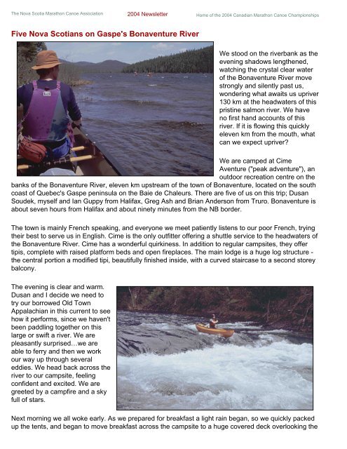
The Nova Scotia <strong>Marathon</strong> <strong>Canoe</strong> Association 2004 Newsletter <strong>Home</strong> of the 2004 Canadian <strong>Marathon</strong> <strong>Canoe</strong> ChampionshipsFive Nova Scotians on Gaspe's Bonaventure RiverWe stood on the riverbank as theevening shadows lengthened,watching the crystal clear waterof the Bonaventure River movestrongly and silently past us,wondering what awaits us upriver130 km at the headwaters of thispristine salmon river. We haveno first hand accounts of thisriver. If it is flowing this quicklyeleven km from the mouth, whatcan we expect upriver?We are camped at CimeAventure ("peak adventure"), anoutdoor recreation centre on thebanks of the Bonaventure River, eleven km upstream of the town of Bonaventure, located on the southcoast of Quebec's Gaspe peninsula on the Baie de Chaleurs. There are five of us on this trip; DusanSoudek, myself and Ian Guppy from Halifax, Greg Ash and Brian Anderson from Truro. Bonaventure isabout seven hours from Halifax and about ninety minutes from the NB border.The town is mainly French speaking, and everyone we meet patiently listens to our poor French, tryingtheir best to serve us in English. Cime is the only outfitter offering a shuttle service to the headwaters ofthe Bonaventure River. Cime has a wonderful quirkiness. In addition to regular campsites, they offertipis, complete with raised platform beds and open fireplaces. The main lodge is a huge log structure -the central portion a modified tipi, beautifully finished inside, with a curved staircase to a second storeybalcony.The evening is clear and warm.Dusan and I decide we need totry our borrowed Old TownAppalachian in this current to seehow it performs, since we haven'tbeen paddling together on thislarge or swift a river. We arepleasantly surprised…we areable to ferry and then we workour way up through severaleddies. We head back across theriver to our campsite, feelingconfident and excited. We aregreeted by a campfire and a skyfull of stars.Next morning we all woke early. As we prepared for breakfast a light rain began, so we quickly packedup the tents, and began to move breakfast across the campsite to a huge covered deck overlooking the
iver, sort of a wilderness bistro. Before long it began raining heavily but we remained comfortable anddry, congratulating ourselves on our preemptive management.After breakfast we got out the rain gear, and moved our canoes and gear up to the main parking lot tomeet our shuttle. The shuttle turns out to be a modified school bus. <strong>Canoe</strong>s are hoisted up on a rack onthe roof and tied down. Gear goes in the back of the bus. Two other paddlers from Vermont joinedus…whitewater open boaters.We began driving through rolling coastal farmland and crossed the river several miles up. From here,we began to climb into the interior, following rough logging roads as we dropped and then climbed, andtwisted our way up into the Chic Choc mountains - a remnant of the Appalachian range that extendsfrom the Carolinas all the way long the US Eastern seaboard. Midway along the shuttle we entered ahuge burn area. Five years earlier, a fire had raged for two months burning hundreds of hectares ofmature forest on both sides of the river. The smoke from this fire was so thick that it tinted the daylighthours in Nova Scotia. A stubble of black and grey limbless trunks covered the green, rounded hills asfar as we could see from the dusty windows of our bus, as it bounced and groaned upwards.The rain stopped at some point and the sun began to appear. We could see patches of snow up on thenorth-facing slope near the summit of the higher hills. We crossed several tributaries and then took asteep side cut around a hill and down into the Bonaventure River valley. Butch, our driver, said we wereat an alternate put-in below Bonaventure Lake and below several nasty log jams. Our Vermont friendsdecided to start at this point. We discussed it at some length, and decided that we had come to do thewhole river. We left most of our gear behind and hopped back into the bus to continue for another hourfurther upriver to Bonaventure Lake, the birthplace of the Bonaventure River.We arrived about 12:30 pm and quickly unloaded our boats. It was sunny and warm, and a strong windwas blowing down the lake. The water was becoming choppy as we started off on a one km paddle tothe end of the lake. We reached the end of the lake and looked back. All around the lake, the hills werecloaked in a dark green mantle of mature spruce and fir. Ahead, the river flowed through a leaflessforest of twisted, burnt trunks.At this point the river is less than two canoe-lengths wide, and about one foot deep. The water is crystalclearand running at about 4 km/hr at a constant incline. The river snakes back and forth between thehills and very soon enters Little Bonaventure Lake. After a short downwind paddle we again entered theriver, always anticipating the log jams. The river continued to twist down the valley, with just enoughwater to cover the rounded boulders and gravel that make up the bottom. For the next hour we wereswept along by the current and encountered nothing that required portaging or liningAs the valley broadened, the river suddenly divided into several small channels around some smallislands choked with logs. We got out and surveyed the area in the belief that this must be the logjamreferred to. The channel to the right appeared to be clear, and after a short wade and a singlecarryover, we were back running downriver. In another ½ hr we saw the side cut along the right side ofthe valley leading down to the river, and by 3:30 pm we had arrived at the first drop-off and our gear,never having encountered any real difficulty. Prompted by guilt, we considered going further in searchof some tripping purgatory, but decided instead to enjoy a nice flat camping area, the warm sun, and anopportunity for an evening hike up the road to the top of the hills.