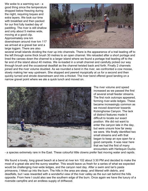
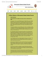
We woke to a warming sun - agood thing since the temperaturedropped below freezing duringthe night, requiring toques andextra layers. We took our timewith breakfast and then packedfor our first fully loaded day ofpaddling. The river is still shallowand only about 5 metres wide,moving at a good clip.Approximately one kmdownstream around river km 117we arrived at a gravel bar and alarge logjam. There are alsoseveral small islands dividing the river up into channels. There is the appearance of a trail leading off tothe left through some thick brush 30 metres to an open channel. We reloaded after a short portage andlined the canoes down the channel to a larger island where we found a portage trail leading off to thefar end of the island about 40 metres. We re-loaded in a small channel and carefully picked our waythrough brush and the occasional deadfall as the channel twisted back and forth. Finally 2 channelsjoined and the river volume doubled. As we rounded a bend in the river, we confronted a cow moose,slowly making her way upstream. She stopped and peered myopically at us for a second and thenquickly turned and strode downstream and into a thicket. The river bend offered good landing on anarrow gravel point where we ate a quick lunch and moved on.The river volume and speedincreased as we passed the firstof several small feeder streams.The first rock outcrops appeared,forming river-wide ledges. Thesebecame increasingly common aswe moved downriver towardsKickinghorse Canyon. The lackof distinct features made itdifficult to locate our exactposition. We did not want toenter the canyon late in the day,but were unsure how far awaywe were. We finally identified twosmall streams and with thatbegan to keep an eye open for agood campsite. It was near herethat we had the first of manyencounters with Harlequin Ducks- a species extremely rare in the East. These colourful little clowns prefer fast moving water and rapids.We found a lovely, long gravel beach at a bend at river km 102 about 3:30 PM and decided to make themost of a great site and the sunny weather. This would leave us fresh for a series of what we expectedwould be challenging river-wide ledges, and the canyon next day. After a swim and Ian's pastaprimavera, I hiked up into the burn. The hills in the area are steep, and littered with debris, anddeadfalls, but I was rewarded with a wonderful view of the river valley as the sun set behind the hillsopposite. From here I could also see the southern edge of the burn. Once again we have the luxury of ariverside campfire and an endless supply of driftwood.
We all got up around 6:30 (everyone seems to be an early riser)to an early morning chill as the sun isnot yet above the surrounding hills. We ate a leisurely breakfast and pushed off around 9:30, just as thesun made it over the eastern hills. The valley narrowed and the forest closed in as we passed thesouthern edge of the burn around km 99. From km 98 we encountered almost continuous Class 1-2rapids, with some exciting ledges thrown in; however we were able to boat scout most of them, and allwere runnable. At km 96 we pulled out to scout a series of ledges, just above the canyon. At higherwater they might be runnable, but we decided to line the two ledges along the right bank, to the edge ofKickinghorse Canyon. There is a wonderful campsite on river right at the ledges. The ledges are tricky,but appeared doable in an empty canoe; however, we decided to press on since it was already midday.The opening to the canyon is dramatic - the river squeezes between high exposed rock walls, anddisappears around the corner. We were apprehensive, but found we were able to boat scout most ofthe ledges and rapids. The canyon is not as long as it appears on the map and actually begins to openup after a kilometer or so. We stopped to look at a beautiful waterfall on river left at km 92. Beyond km90 the river valley opens up again as the river becomes shallower and wider. We enjoyed this newlandscape, and for the first time saw a cabin or two at about km 86. We passed the first major streamon river left at km 84 called Rousseau Mourir, and found a wonderful gravel bar on a bend about onekm farther. Ian took the plunge off a diving log into a deep pool. Later, a resident beaver advertised hisdislike of our company by repeatedly slapping his tail as we finished dinner in the fading light of anotherperfect day.We were up early, had breakfast and packed quickly and efficiently after three days of practice. Highcloud began to move in as we set off down river. The river valley widens and we saw a few more cabinsalong the edge of the river. Most of the time we encountered sections of fast water created by gravelbars, and we began to see salmon fishing areas posted. We ran a number of ledges including asignificant one at Grand Black pool, after rounding a sharp bend. Dusan and I sneaked left while Brianand Greg decided to take it head on riding out some very large standing waves.We passed the only significanttributary, the West BonaventureRiver at km 67 and continued tosee more salmon fishinginfrastructure. There is an accessroad on river right from the WestBonaventure. We ran into a bit ofrain, but made great time, andtook out at a large open area onriver right at km 49, just past alarge island, and just above thebridge at km 48. This area isused and maintained by CimeAventure and sports an unusual,round, sweet-smelling cedarbiffy. We set up a cooking tarp,expecting more rain. A slowdrizzle started as we preparedsupper, and the temperature dropped. We had made excellent time and expected to be able to finishthe river the next day.The next morning mist hung on the trees up the steep sides of the river valley, and wisps of mist formedon the river surface and rose like smoke. It is damp, but not quite raining as we finished off a fabulous