

VEGETATION MANAGEMENT PLAN for Bidjigal Reserve - Land
VEGETATION MANAGEMENT PLAN for Bidjigal Reserve - Land
VEGETATION MANAGEMENT PLAN for Bidjigal Reserve - Land

You also want an ePaper? Increase the reach of your titles
YUMPU automatically turns print PDFs into web optimized ePapers that Google loves.
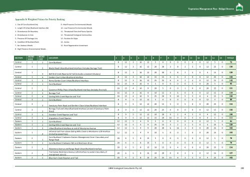
Vegetation Management Plan - <strong>Bidjigal</strong> <strong>Reserve</strong>Appendix 9: Weighted Values <strong>for</strong> Priority Ranking1 - Size Of Core Bushland (Ha) 9 - Med Presence Environmental Weeds2 - Length Of Urban/Bushland Interface (M) 10 - Low Presence Environmental Weeds3 - Disturbances On Boundary 11 - Threatened Flora And Fauna Species4 - Disturbances In Core 12 - Threatened Ecological Communities5 - Presence Of Drainage Line 13 - Position On Slope6 - Condition Of Bushland Rank 14 - Access7 - No. Noxious Weeds 15 - Bush Regeneration Investment8 - High Presence Environmental WeedsMGMT MGMTSECTIONLOCATION 1 2 3 4 5 6 7 8 9 10 11 12 13 14 15 TOTALSZONE UNITCentral 1 1 Core Bushland 8 12 3 16 12 5 0 0 0 0 0 0 12 5 0 73Central 12 Blacks Road Urban/Bushland Interface (includes Burraga Trail)8 12 3 16 12 20 30 3 8 2 5 0 12 25 0 156Central 13 Bell Bird Creek Riparian & Trail (includes unnamed tributary)8 12 3 16 12 20 30 3 8 2 5 0 4 15 0 138Central 1 4 Garden Court Urban/Bushland Interface 8 12 3 16 12 15 15 6 6 2 0 0 12 25 0 132Central 1 5 Roma Garden Court Urban/Bushland Interface 8 12 3 16 12 25 25 6 6 2 o 0 12 15 0 142Central 2 1 Core Bushland 16 15 4 16 9 5 0 0 0 0 5 0 20 5 0 95Central 22 Governor Phillip Place Urban/Bushland Interface (Includes fire trail)16 15 4 16 9 20 5 0 0 1 0 0 20 25 0 131Central 2 3 Burraga Trail 16 15 4 16 9 10 15 0 6 0 0 0 12 15 0 118Central 2 4 Darling Mills Creek Riparian and Trail 16 15 4 16 9 25 20 9 10 5 5 0 4 15 5 158Central 3 1 Core Bushland 8 9 5 12 12 5 0 0 0 0 0 0 12 5 0 68Central 32 Sanctuary Point Road and Glenfern Close Urban/Bushland Interface8 9 5 12 12 20 15 3 0 5 0 0 20 25 0 134Central 3Burraga Trail and Urban/Bushland Interface (at end of Sanctuary Point3 Road)8 9 5 12 12 20 25 6 8 0 0 0 12 15 0 132Central 3 4 Excelsior Creek Riparian and Trail 8 9 5 12 12 10 20 0 2 4 5 0 4 15 0 106Central 3 5 Angophora Creek Riparian 8 9 5 12 12 15 20 16 0 0 5 0 4 5 0 111Eastern 1 1 Core Bushland 12 12 5 4 9 5 0 0 0 0 0 0 12 5 0 64Eastern 1 2 Darling Mills Creek Riparian and Trail 12 12 5 4 9 25 15 3 2 2 5 0 4 25 5 128Eastern 1 3 Urban/Bushland Interface at end of Merelynne Avenue 12 12 5 4 9 20 30 6 16 3 0 0 20 25 0 162Eastern 1In<strong>for</strong>mal trail from above Daling Mills Creek to Merelynne U/B Interface4 (including powerlines)12 12 5 4 9 10 5 0 0 1 0 0 20 25 0 103Eastern 2Core Bushland 1 between Eastern Management Zone 1 boundary and1 Range Road20 6 5 8 15 5 0 0 0 0 0 0 12 5 0 76Eastern 2 2 Core Bushland 2 between M2 and Westmore Drive 20 6 5 8 15 5 0 0 0 0 0 0 12 5 0 76Eastern 220 6 5 8 15 10 15 0 4 6 0 0 20 25 0 1343 Westmore Avenue and Range Road Urban/Bushland InterfaceTrail below Westmore Avenue U/B Interface to eastern boundary ofEastern 220 6 5 8 15 10 20 0 8 3 5 0 12 15 0 1274 managment zone E1Eastern 2 5 Blue Gum Creek Riparian and Trail 20 6 5 8 15 25 25 15 6 3 5 0 4 25 0 162UBM Ecological Consultants Pty Ltd 200


