VFR/GPS CHART UPDATE
VFR/GPS CHART UPDATE
VFR/GPS CHART UPDATE

You also want an ePaper? Increase the reach of your titles
YUMPU automatically turns print PDFs into web optimized ePapers that Google loves.
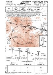
14 JUNE 11 <strong>VFR</strong> ENROUTE CHANGE NOTICES US-1<br />
<strong>VFR</strong>+<strong>GPS</strong> <strong>CHART</strong>S NORTH AMERICA<br />
Jeppesen <strong>CHART</strong> CHANGE NOTICES highlight only significant changes affecting<br />
Jeppesen Charts, also regularly updated at www.jeppesen.com.<br />
IMPORTANT: CHECK FOR NOTAMS AND OTHER PERTINENT<br />
INFORMATION PRIOR TO FLIGHT.<br />
<strong>VFR</strong> ENROUTE <strong>CHART</strong>S<br />
GENERAL NOTICES<br />
The Chart Change Notices are valid for the following<br />
Chart editions:<br />
Great Lakes:<br />
GL-1 (4 th ), GL-2 (4 th ), GL-3 (6 th ), GL-4 (4 th ), GL-5 (3 rd ),<br />
GL-6 (3 rd ), GL-7 (3 rd ), GL-8 (3 rd ), GL-9 (3 rd )<br />
North Central:<br />
NC-1 (3 rd ), NC-2 (3 rd ), NC-3 (3 rd ), NC-4 (3 rd ), NC-5 (3 rd ),<br />
NC-6 (3 rd ), NC-7 (3 rd ), NC-8 (3 rd ), NC-9 (3 rd ), NC-10<br />
(3 rd ), NC-11 (3 rd ), NC-12 (3 rd ), NC-13 (3 rd ), NC-14 (6 th ),<br />
NC-15 (3 rd ), NC-16 (3 rd ), NC-17 (3 rd ), NC-18 (3 rd ),<br />
NC-19 (3 rd )<br />
North East:<br />
NE-1(4 th ), NE-2 (4 th ), NE-3 (4 th ), NE-4 (3 rd ), NE-5 (3 rd ),<br />
NE-6 (3 rd ), NE-7 (3 rd )<br />
South Central:<br />
SC-1 (5 th ), SC-2 (5 th ), SC-3 (3 rd ), SC-4 (3 rd ), SC-5 (3 rd ),<br />
SC-6 (3 rd ), SC-7 (3 rd ), SC-8 (3 rd ), SC-9 (3 rd ), SC-10<br />
(3 rd ), SC-11 (3 rd ), SC-12 (3 rd ), SC-13 (3 rd ), SC-14 (3 rd ),<br />
SC-15 (3 rd ), SC-16 (3 rd )<br />
South East:<br />
SE-1 (5 th ), SE-2 (5 th ), SE-4 (6 th ), SE-5 (4 th ), SE-6 (4 th ),<br />
SE-7 (6 th ), SE-8 (6 th )<br />
Western:<br />
W-1 (6 th ), W-2 (6 th ), W-3 (5 th ), W-4 (4 th ), W-5 (5 th ),<br />
W-6 (3 rd ), W-7 (3 rd ), W-8 (4 th ), W-9 (3 rd ), W-10 (3 rd ),<br />
W-11(3 rd ), W-12 (3 rd ), W-13 (3 rd ), W-14 (3 rd ), W-15 (3 rd ),<br />
W-16 (3 rd ), W-17 (3 rd ), W-18 (3 rd )<br />
GREAT LAKES REGION<br />
AIRPORTS<br />
��Airport annotation at N423247 W0940335 is missing. Add<br />
ST CLOUD REGL KSTC<br />
CTWR 118.25 * (CTAF)<br />
ATIS 119.37<br />
ASOS 112.10<br />
Elevation: 1031<br />
Rwy length: 7000 [GL-9]<br />
�Abraham Lincoln Meml Hospital, 20LL.<br />
New medical heliport estbld at N400911 W0892327 [GL-3]<br />
�Advanced Asphalt, LL08.<br />
New civil heliport estbld at N412309 W0892817 [GL-3]<br />
�AE 92, 9KY2.<br />
New medical heliport estbld at N374543 W0862710 [GL-7]<br />
�Airborne Airpark, ILN.<br />
Apt name chgd to WILMINGTON AIR PARK [GL-4]<br />
�Ambler – Cady, 7IL9.<br />
Apt perm withdrawn (N413238 W0885936) [GL-3]<br />
�Aurora Medical Center Kenosha, WI01.<br />
Heliport withdrawn (N423712 W0875610) [GL-3]<br />
�Aurora Medical Center, WI06.<br />
Heliport withdrawn (N440738 W0873656) [GL-3]<br />
�Austin Straubel Intl, GRB. UNICOM freq withdrwn [GL-3]<br />
�Bass Lake, 81IN. Location ID chgd to 01L, apt use chgd<br />
to public, rwy length chgd to 13309’, CTAF freq estbld<br />
122.90 MHz [GL-2]<br />
�Bayes, 9OI7. Apt perm withdrawn (N402024 W0831703) [GL-4]<br />
�Bernie’s, OA10.<br />
Apt name chgd to WORKMANS LANDING [GL-4]<br />
�Bonnie Field, MI00.<br />
Apt perm withdrwn (N460308 W0871529) [GL-8]<br />
�Borgess Medical Center, 5MI5.<br />
New medical heliport estbld at N421830 W0853338 [GL-2]<br />
�Bronson Methodist Hospital, 9MI9.<br />
New medical heliport estbld at N421713 W0853450 [GL-2]<br />
Burlington Mun, BUU. AWOS-3 freq estbld 114.50 MHz [GL-3]<br />
Please Visit Jeppesen’s Web Site: www.jeppesen.com © JEPPESEN, 2011. ALL RIGHTS RESERVED.<br />
�<br />
�<br />
Chapman Meml Field, OH71. Location ID chgd to OH0,<br />
apt use chgd to public, CTAF freq estbld 122.90 MHz [GL-4]<br />
Chicago O'Hare Intl, ORD. TWR freq 128.15 MHz<br />
additional information estbld RY 9L/27R [GL03]<br />
Clinton Meml Hospital, 1OH0<br />
New medical heliport estbld at N392639 W0835025 [GL-4]<br />
Columbia St. Mary's, 23WS.<br />
New medical heliport estbld at N430339 W0875251 [GL-3]<br />
Communty Health Center of Branch Co, MI85.<br />
New medical heliport estbld at N415615 W0845917 [GL-2]<br />
Communty Meml Hospital, WS21.<br />
New medical heliport estbld at N430950 W0880822 [GL-3]<br />
Communty Meml Hospital, 22WI.<br />
New medical heliport estbld at N445154 W0880742 [GL-3]<br />
Courtland, 9A4. AWOS freq estbld 118.52 MHz [GL-7]<br />
�<br />
�<br />
�<br />
�<br />
�<br />
�<br />
�<br />
�Crispy Cedars, 7WI8. New private apt estbld at N444650<br />
W0873609, elev 700’, rwy length 2000’ (unpaved) [GL-3, GL-9]<br />
�Crystal Lake Holiday Inn, IL18.<br />
New civil heliport estbld at N421314 W0881705 [GL-3]<br />
Donn, 550H. Heliport withdrawn (N412833 W0815702) [GL-1]<br />
�<br />
�<br />
�<br />
Edgar CO, PRG. AWOS-3 freq estbld 124.17 MHz [GL-3, GL-7]<br />
EMH Regl Medical Center, OI23.<br />
New medical heliport estbld at N412154 W0820552 [GL-1]<br />
�Evart Mun, 9C8. ARP chgd to N435343 W0851703,<br />
rwy length chgd to 4184’ [GL-2]<br />
�Flugplatz, 2MI7. Location ID chgd to 7MI, apt use chgd<br />
to public, CTAF freq estbld 122.90 MHz [GL-1]<br />
�Fostoria Community Hospital, 99OI.<br />
New medical heliport estbld at N410946 W0832526 [GL-1]<br />
�Franklin Co Meml Hospital, VG46.<br />
Heliport withdrawn (N365934 W0795326) [GL-4]<br />
�Good Samaritan Medical Center, 00OH.<br />
New medical heliport estbld at N391212 W0844012 [GL-4]<br />
�Gruetter, 5OI7. Apt perm withdrwn (N413533 W0832232) [GL-1]<br />
�Hamilton Lake, IN02. Location ID chgd to 01F, apt use<br />
chgd to public, rwy length chgd to 6000’, CTAF freq estbld<br />
122.90 MHz [GL-2]<br />
�Henry Ford Wyandotte Hospital, MI61.<br />
New medical heliport estbld at N421230 W0830889 [GL-1]<br />
�Highland District Medical, OH69.<br />
New medical heliport estbld at N391316 W0833639 [GL-4]<br />
�Hillenbrand Industries, HLB. Apt light chgd to RDO-CTL [GL-4]<br />
Hillsdale Mun, JYM. Rwy length chgd to 5000’ [GL-1, GL-2]<br />
�<br />
�<br />
Hoopeston Community Meml Hospital, 01IL.<br />
New medical heliport estbld at N402731 W0873934 [GL-3]<br />
Howard Nixon Meml, 50G. Rwy length chgd to 2800’ [GL-1]<br />
�<br />
�<br />
Huron Co Meml, BAX. AWOS frq chgd to 118.60MHz [GL-1]
14 JUNE 11 <strong>VFR</strong> ENROUTE CHANGE NOTICES US-2<br />
�Il. Dept. Of Transportation, 2IL8.<br />
New civil heliport estbld at N420114 W0881658 [GL-3]<br />
�Iola Emergency, WI64.<br />
New medical heliport estbld at N443025 W0890810 [GL-3]<br />
�James Clements Mun, 3CM.<br />
CTAF freq chgd to 122.72 MHz [GL-1]<br />
�Jott, 9MI8.<br />
New civil heliport estbld at N423939 W0825947 [GL-1]<br />
�King's Daughters Medical Center, 4KY9.<br />
Heliport withdrawn (N382815 W0823806) [GL-4]<br />
�Lake James, 6IN9. Location ID chgd to 01E, apt use<br />
chgd to public, CTAF freq estbld 122.90 MHz [GL-2]<br />
�Lake Maxinkuckee, IG22. Location ID chgd to 01H, apt use<br />
chgd to public, rwy length chgd to 7000’, CTAF freq estbld<br />
122.90 MHz<br />
�Lake Wawasee, 1IN7. Location ID chgd to 01F, apt use<br />
chgd to public, rwy length chgd to 6000’, CTAF freq<br />
[GL-2]<br />
estbld 122.90MHz [GL-2]<br />
�Lakeview Airport-Griffith Field, 13C.<br />
Apt name chgd to LAKEVIEW-GRIFFITH FIELD [GL-2]<br />
�Lee Meml Hospital, 13MI.<br />
New medical heliport estbld at N415901 W0860657 [GL-2]<br />
�Lewis Gale Clinic INC., 1VA2.<br />
New medical heliport estbld at N371545 W0800153 [GL-4]<br />
�Lima Meml Hospital, OH83.<br />
New medical heliport estbld at N404410 W0840515 [GL-4]<br />
�Loars Field, MI51.<br />
Apt perm withdrwn (N415949 W0841119) [GL-1]<br />
�Lourdes Hospital, 01KY.<br />
Heliport withdrawn (N370306 W0883849) [GL-7]<br />
�Medical Center Manchester, 24TN.<br />
Heliport withdrawn (N352951 W0860443) [GL-7]<br />
�Meml Medical Center, WS63.<br />
New medical heliport estbld at N463404 W0905325 [GL-8]<br />
�Mercy Hospital, WS40.<br />
New medical heliport estbld at N424118 W0890157 [GL-3]<br />
�Mercy Medical Center, WS50.<br />
Heliport withdrawn (N440125 W0883122) [GL-3]<br />
�Meriter Park, WI93.<br />
New medical heliport estbld at N430356 W0892406 [GL-3]<br />
�Mount Comfort, MQJ.<br />
Apt name chgd to INDIANAPOLIS REGL [GL-4]<br />
�Nappanee Mun, C03. CTAF freq chgd to 123.00 MHz [GL-2]<br />
�Northshore Glenbrook Hospital, 0IS2.<br />
New civil heliport estbld at N420535 W0881658 [GL-3]<br />
�<br />
Oakwood Heritage Hospital, 05MI.<br />
New medical heliport estbld at N421411 W0875109 [GL-1]<br />
Olive Hill-Sellers' Field, 2I2. Apt status chgd to closed<br />
Omniflight Helicopters, WI85.<br />
[GL-4]<br />
Heliport withdrawn (N423041 W0871538) [GL-3]<br />
Overflow Pad Lower Pad.<br />
New medical heliport estbld at N421720 W0834350 [GL-1]<br />
Paul C. Miller-Sparta, 8D4.<br />
AWOS freq chgd to 132.95 MHz [GL-2]<br />
Peach Lake, 89MI.<br />
New civil heliport estbld at N441728 W0841032 [GL-1]<br />
Porter Co Mun, VPZ.<br />
Apt name chgd to PORTER CO REGL [GL-2]<br />
Prairie Lake Hunt Club, 68IL.<br />
Apt perm withdrwn (N412342 W0884058) [GL-3]<br />
Rainbow, 7B1. Heliport withdrwn (N404632 W0894033) [GL-3]<br />
�<br />
�<br />
�<br />
�<br />
�<br />
�<br />
�<br />
Reedsburg Meml Hospital, WS54.<br />
New medical heliport estbld at N433301 W0895932 [GL-3]<br />
Resurrection Medical Center, IL79.<br />
New medical heliport estbld at N415910 W0874853 [GL-3]<br />
Riverside Hospital, 5WI7.<br />
New medical heliport estbld at N442009 W0890500 [GL-3]<br />
Robertson's Roost, 8IL6.<br />
Apt perm withdrwn (N385134 W0883931) [GL-7]<br />
�<br />
�<br />
�<br />
�Robinson Mun, RSV.<br />
Apt name chgd to CRAWFORD CO [GL-7]<br />
�Scottsboro Mun-Word Field, 4A6.<br />
AWOS freq estbld 120.12 MHz [GL-7]<br />
Seneca CO, 16G. AWOS-3 freq chgd to 127.12 MHz [GL-1]<br />
Please Visit Jeppesen’s Web Site: www.jeppesen.com © JEPPESEN, 2011. ALL RIGHTS RESERVED.<br />
�<br />
�<br />
Shady Lawn Field, 4M4. New public apt estbld at N430743<br />
W0842253, elev 680’, rwy length 1850’ (unpaved) [GL-1, GL-2]<br />
Shawano Medical Center, 98WI.<br />
New medical heliport estbld at N444705 W0883704 [GL-3]<br />
St Clare Hospital, WI30.<br />
New medical heliport estbld at N432853 W0894346 [GL-3]<br />
St Joseph’s Community Hospital, WS66.<br />
New medical heliport estbld at N432504 W0881133 [GL-3]<br />
St Mary’s Hospital of Milwaukee, WS03.<br />
New medical heliport estbld at N430342 W0875245 [GL-3]<br />
St Mary’s Hospital Ozaukee, 8WI4<br />
New medical heliport estbld at N432347 W0875235 [GL-3]<br />
St Mary Medical Center, 00IN.<br />
Heliport withdrawn (N413041 W0871538) [GL-3]<br />
St Vincent Hospital, 7WI3.<br />
New medical heliport estbld at N443005 W0880041 [GL-3]<br />
Tippecanoe, IN16. Location ID chgd to 01B, apt use<br />
chgd to public, CTAF freq estbld 122.90 MHz [GL-2]<br />
UMMC MI32.<br />
New medical heliport estbld at N421720 W0834341 [GL-1]<br />
University Hospital Sicu, 8OH9.<br />
Heliport withdrawn (N390814 W0843010) [GL-4]<br />
University Of Illinois-Willard, CMI.<br />
TWR freq 118.25 MHz chgd to 127.82 MHz [GL-3, GL-7]<br />
UW Hospital & Clinics, WS27.<br />
New medical heliport estbld at N430433 W0892558<br />
VA Hospital, OI21.<br />
[GL-3]<br />
New medical heliport estbld at N392200 W0826000<br />
Waukesha Meml Hospital, 6WI8.<br />
[GL-4]<br />
New medical heliport estbld at N430040 W0881434<br />
Wausau Hospital Center, WS65.<br />
[GL-3]<br />
New medical heliport estbld at N445800 W0894003<br />
Winona Lake, 08IN. Location ID chgd to 02D, apt use<br />
[GL-3]<br />
chgd to public, CTAF freq estbld 122.90 MHz [GL-2]<br />
�<br />
�<br />
�<br />
�<br />
�<br />
�<br />
�<br />
�<br />
�<br />
�<br />
�<br />
�<br />
AIRSPACE<br />
CLASS B Cleveland, OH amended.<br />
This action establishes two airspace extensions (Area E,<br />
to the NE, and Areas F & G, to the SW).<br />
Area E extends from the existing Area D boundary defined<br />
by the 20-mile arc of I-HPI to the 30-mile arc of I-HPI. The<br />
northern boundary of this area is 6 miles north and parallel to<br />
the Runway 24R localizer (I-PVY) signal extended, and the<br />
southern boundary is 6 miles south and parallel to the Runway<br />
24L localizer (I-FVZ) signal extended. This new area is estbld<br />
with the floor extending upward from 5,000 feet MSL to and<br />
including 8,000 feet MSL.<br />
Area F extends from the existing Area D boundary defined by<br />
the 20-mile arc of I-HPI to the 30-mile arc of I-HPI. The northern<br />
boundary is 6 miles north and parallel to the Runway 6L<br />
localizer (I-LIZ) signal extended, and the southern boundary is<br />
defined by the Runway 6R localizer (I-CLE) signal extended.<br />
This new area is estbld with the floor extending upward from<br />
5,000 feet MSL to and including 8,000 feet MSL.<br />
Area G extends from the existing Area D boundary defined by<br />
the 20-mile arc of I-HPI to the 30-mile arc of I-HPI. The northern<br />
boundary is defined by the Runway 6R localizer (I-CLE) signal<br />
extended, and the southern boundary is defined 6 miles south<br />
and parallel to the Runway 6R localizer (I-EYU) signal<br />
extended. This new area is estbld with the floor extending<br />
upward from 6,000 feet MSL to and including<br />
8,000 feet MSL. [GL-1]<br />
�
14 JUNE 11 <strong>VFR</strong> ENROUTE CHANGE NOTICES US-3<br />
�CLASS E Benton, IL estbld. That airspace extending upward<br />
from 700 feet above the surface within a 6.4-mile radius of<br />
Benton Municipal Airport. [GL-7]<br />
�<br />
CLASS E Charleston, WV amended.<br />
That airspace extending upward from 700 feet above the<br />
Surface within a 7-mile radius of Yeager Airport and within<br />
8 miles northwest and 4 miles southeast of the 048° bearing<br />
from the airport extending from the 7-mile radius to 21.2 miles<br />
northeast of the airport [GL-4, GL-5]<br />
�<br />
CLASS E Columbus, OH amended.and that airspace within<br />
3.3 miles either side of the 094º bearing from Port Columbus<br />
International Airport (N395953 W0825331) extending from the<br />
7-mile radius to 12.1 miles east of the airport, excluding that<br />
airspace within the London, OH, Class E airspace area. [GL-4]<br />
�<br />
CLASS E Greensburg, IN amended. That airspace extending<br />
upward from 700 feet above the surface within a 6.3-mile radius<br />
of Greensburg-Decatur County Airport, and within a 6-mile<br />
radius of the Decatur County Memorial Heliport point in space<br />
coordinates at N392110 W852909. [GL-4, GL-6]<br />
�<br />
CLASS E Henderson, KY amended. That airspace extending<br />
upward from 700 feet above the surface within a 6.5-mile radius<br />
of the Henderson City-County Airport (N374828 W0874109) and<br />
within 1.0 miles each side of the 333º radial from the Pocket<br />
City VORTAC (N375542 W0874545) extending from the 6.5mile<br />
radius of the Henderson City-County Airport to 8.2 miles<br />
southeast of the VORTAC. [GL-7]<br />
�<br />
CLASS E Lafayette, IN amended.<br />
That airspace extending upward from 700 feet above the<br />
surface within a 6.7-mile radius of Purdue University Airport,<br />
and within 1.7 miles each side of the 144° radial of the Boiler<br />
VORTAC extending from the 6.7-mile radius to the VORTAC,<br />
and within a 6-mile radius of the Clarian Arnett Heliport point<br />
in space at.N402330 W0864858 [GL-2, GL-3, GL-6]<br />
�<br />
CLASS E La Porte, IN amended.<br />
That airspace extending upward from 700 feet above the<br />
surface within a 7.3-mile radius of La Porte Municipal Airport,<br />
and within 2.5 miles each side of the 201° bearing from the<br />
La Porte NDB extending from the 7.3-mile radius to 11.4 miles<br />
south of the airport, and within a 6-mile radius of the La Porte<br />
Hospital Heliport point in space at N413611 W0864410 [GL-2]<br />
�<br />
CLASS E Martinsville, IN amended.<br />
That airspace extending upward from 700 feet above the<br />
surface within a 6-mile radius of the Morgan Hospital Heliport<br />
point in space at N392500 W0862449 [GL-6, GL-7]<br />
�<br />
CLASS E Mansfield, OH amended and within 4 miles each<br />
side of the 137º bearing from Mansfield Lahm Regional Airport<br />
(N404917 W0823100) extending from the 6.9-mile radius to<br />
11.1 miles southeast of the airport, and within 4 miles each side<br />
of the 317[deg] bearing from Mansfield Lahm Regional Airport<br />
extending from the 6.9-mile radius to 10.7 miles northwest of the<br />
airport, and within 4 miles each side of the 047º bearing from<br />
Mansfield Lahm Regional Airport extending from the 6.9-mile<br />
radius to 11.2 miles northeast of the airport, and within 4 miles<br />
each side of the 227º bearing from Mansfield Lahm Regional<br />
Airport extending from the 6.9-mile radius to 10.9 miles<br />
southwest of the airport, and within 6.1 miles each side of the<br />
Mansfield VORTAC (N405207 W0823528) 307º radial extending<br />
from the 6.9-mile radius to 13.3 miles northwest of the<br />
VORTAC, and within 4.4 miles each side of the Mansfield<br />
VORTAC 130º radial extending from the 6.9-mile radius to 13.8<br />
miles southeast of the VORTAC. [GL-1]<br />
�<br />
CLASS E Muncie, IN amended. That airspace extending<br />
upward from 700 feet above the surface within a 7-mile radius of<br />
Delaware County Regional Airport, and within a 6-mile radius of<br />
the Ball Memorial Hospital Heliport point in space coordinates at<br />
N401150 W0852552 [GL-2, GL-4, GL-5, GL-6]<br />
�CLASS E Richmond, IN amended.<br />
That airspace extending upward from 700 feet above the<br />
surface within a 7-mile radius of Richmond Municipal Airport,<br />
and within a 6-mile radius of the Reid Hospital Heliport point in<br />
space at N395225 W0845324 W [GL-4, GL-5, GL-6]<br />
Please Visit Jeppesen’s Web Site: www.jeppesen.com © JEPPESEN, 2011. ALL RIGHTS RESERVED.<br />
�<br />
CLASS E Savannah, TN amended and within 3.7 miles each<br />
side of the 008º bearing from the airport extending from the<br />
6.5-mile radius to 9.9 miles north of the Savannah-Hardin<br />
County Airport (N351013 W881300). [GL-7]<br />
�<br />
CLASS E Sturgis, KY amended. … and within 4 miles each<br />
side of the 183º bearing from the Sturgis Municipal Airport<br />
(N373230 W0875716) extending from the 6.5-mile radius to 9.9<br />
miles south of the airport: and within 4 miles each side of the<br />
003º bearing from the airport extending from the 6.5-mile radius<br />
to 10 miles north of the Sturgis Municipal Airport. [GL-7]<br />
�Parachute Jumping Area<br />
withdrawn at N464516 W0920613 [GL-8]<br />
�Parachute Jumping Area<br />
withdrawn at N410205 W0835818 [GL-4]<br />
ENROUTE & AIRSPACE COMMUNICATIONS<br />
None<br />
RADIO NAVIGATIONAL FACILITIES<br />
Video, AI. NDB freq chgd from 371 kHz to 394 kHz [GL-4]<br />
WAYPOINTS AND ROUTES<br />
��V-Airway annotation is missing from Lexington HYK to New<br />
Hope EWO. Add V178, distance 60, bearing 251°. [GL-6]<br />
�FULER. VOR Intersection estbld at N400421 W0831153 [GL-4]<br />
�HIINZ.<br />
VOR Intersection withdrwn at N383729 W0822507 [GL-4]<br />
�OBEPE. VOR Intersection estbld at N375423 W0791321 [GL-4]<br />
�VR634. MTR chgd. Remove segments from N445200<br />
W0843500 to N440200 W0842100. Add segment from N445200<br />
W0843500 to N445100 W0842600, add segment from N445100<br />
W0842600 to N440200 W0842100 [GL-1, GL-2]<br />
�WUKYY.<br />
VOR Intersection withdrwn at N373240 W0801850 [GL-4]<br />
YAVUS. VOR Intersection estbld at N405627 W0851546 [GL-2]<br />
�ZEGBI. VOR Intersection estbld at N421422 W0850455 [GL-2]<br />
CHANGES TO LISTINGS ON THE REVERSE SIDE<br />
Airborne Airpark, ILN.<br />
Apt name chgd to WILMINGTON AIR PARK [GL-4]<br />
Chicago O'Hare Intl, ORD. TWR freq 128.15 MHz<br />
additional information estbld RY 9L/27R [GL03]<br />
Gary / Chicago Intl, GYY.<br />
ATIS freq 120.62 MHz chgd to 134.57 MHz [GL-3]<br />
Smyrna, MQY. OPS chgd to 0700-2200 MON-FRI [GL-7]<br />
�<br />
�<br />
�<br />
�<br />
�<br />
University Of Illinois-Willard, CMI.<br />
TWR freq 118.25 MHz chgd to 127.82 MHz [GL-3, GL-7]<br />
NORTH CENTRAL REGION<br />
AIRPORTS<br />
�Abilene Mun, K78.<br />
AWOS-3 freq estbld 124.12 MHz [NC-15, NC-18]<br />
�Abraham Lincoln Meml Hospital, 20LL.<br />
New medical heliport estbld at N400911 W0892327<br />
�Baudette Intl, BDE.<br />
[ NC-16]<br />
Glider activity withdrwn at N484342 W0943644 [NC-3]<br />
�Bigfork Mun, FOZ. Rwy length chgd to 4000’ [NC-3]<br />
�Black River Meml Hospital, 23WI.<br />
New medical heliport estbld at N441814 W0905117 [ NC-10]<br />
�Boone Co Hospital, 02IA.<br />
Heliport withdrawn (N420322 W0935241) [NC-13]
14 JUNE 11 <strong>VFR</strong> ENROUTE CHANGE NOTICES US-4<br />
�Cache Valley Specialty Hospital, 23UT.<br />
New medical heliport estbld at N414629 W1114920 [ NC-11]<br />
�Charles W. Baker, 2M8.<br />
AWOS freq estbld 122.80 MHz [NC-19]<br />
�Cheyenne Eagle Butte, 84 D.<br />
UNICOM freq estbld 122.80 MHz [NC-9]<br />
�<br />
Chippewa Valley Hospital, WI57.<br />
New medical heliport estbld at N443716 W0915117 [ NC-10]<br />
�Circle Town Co, 4U6. Apt elev chgd to 2442’ [NC-2]<br />
�Colorado Springs East, A50. Apt light withdrwn [NC-14]<br />
�Dixon, 9U4. Location ID chgd to DWX [NC-11]<br />
�Ferndale Airfield, 53U. Apt elev chgd to 3072’ [NC-1]<br />
�Fremont Mun, FET. Rwy length chgd to 6350’ [NC13]<br />
�Gen Dewitt Spain, M01.<br />
AWOS freq estbld 122.70 MHz<br />
�Great River Medical Center, 45IA.<br />
[NC-19]<br />
Heliport withdrawn (N404836 W0911024) [NC-16]<br />
�Hayes Emergency Airstrip, SD21.<br />
Rwy surface chgd to paved [NC-9]<br />
�Hebbelmann, 4U4. Apt elev chgd to 2589’ [NC-1]<br />
�Highland, 1IL5.<br />
New civil heliport estbld at N384537 W0894027 [NC-16, NC-19]<br />
�H.J. Paul AHP, 5K3.<br />
Heliport withdrawn (N410360 W0962001) [NC-12, NC-13]<br />
�Houston, 71CO.<br />
Heliport withdrawn (N393303 W1043020) [NC-14]<br />
�Hoytsville, 38UT. New private apt estbld at N405239<br />
W1112233, elev 5800’, rwy length 1800’ (paved) [NC-11]<br />
�<br />
Jesse Viertel Meml, VER.<br />
AWOS-3 freq estbld 119.62 MHz [NC-16]<br />
�Justison, 1LL5. New private apt estbld at N391434 W0893303,<br />
elev 650’, rwy length 2150’ (unpaved) [NC-16, NC-19]<br />
�Lake City Medical Center, 82MN.<br />
New medical heliport estbld at N442736 W0921717 [NC-10]<br />
�Luther Hospital, WS38.<br />
New medical heliport estbld at N444843 W0913046 [NC-10]<br />
�<br />
Mc Kennan Hospital, 2SD1.<br />
New medical heliport estbld at N433203 W0964254 [NC-10]<br />
�Meadow Lake, 00V. Location ID chgd to FLY,<br />
AWOS-3 freq estbld 118.45 MHz [NC-14]<br />
�Medcenter One Hospital Med I Port, ND30.<br />
New medical heliport estbld at N464829 W1004659[NC-5, NC-6]<br />
�<br />
Meml Hospital, WS48.<br />
New medical heliport estbld at N430800 W0904228<br />
�Mission Sioux, 0V6.<br />
[NC-10]<br />
Apt perm withdrwn (N431825 W1003741) [NC-9, NC-12]<br />
�Mobridge Regl Hospital, SD80.<br />
Heliport withdrawn (N453245 W1002656) [NC-6]<br />
�North Meml, MY77.<br />
New medical heliport estbld at N450050 W0931921 [NC-10]<br />
�Northern Itasca Health Care Center, 1MN3.<br />
New medical heliport estbld at N474450 W0933847 [NC-3]<br />
�Northfield Hospital, 48MN.<br />
New medical heliport estbld at N442828 W0931131 [NC-10]<br />
�Oberlin Mun, OIN.<br />
AWOS-3 freq estbld 119.22 MHz [NC-15]<br />
�<br />
Paynesville Mun, PEX. AWOS freq 120.35 MHz<br />
chgd from AWOS-3 to AWOS-A [NC-6]<br />
�Rainbow, 7B1.<br />
Heliport withdrwn (N404631 W0894033) [NC-13, NC-16]<br />
�Rangely District Hospital, 18CO.<br />
Heliport withdrwn (N400451 W1084814) [NC-17]<br />
�Rapid City Regl Hospital, SD40.<br />
New medical heliport estbld at N440328 W1031335 [ NC-9]<br />
�Reedsburg Meml Hospital, WS54.<br />
New medical heliport estbld at N433301 W0895932 [ NC-10]<br />
�Salina Mun, SLN.<br />
Additional Tower freq estbld 124.35 MHz [NC-18]<br />
�Salina Regl Health Center, SN73.<br />
Heliport withdrawn (N384952 W0973639) [NC-15, NC-18]<br />
Sherman AAF, FLV. Rwy length chgd to 5318’ [NC-16]<br />
�<br />
�Standing Rock, Y27. Apt light estbld (Dusk-Dawn) [NC-5, NC-6]<br />
�St Alexius Med I Port, ND46.<br />
New medical heliport estbld at N464827 W1004636 [NC-5, NC-6]<br />
�St Charles, 3SQ. Apt closed, Glider activity<br />
withdrwn (N385055 W0903000) [NC-16, NC-19]<br />
Please Visit Jeppesen’s Web Site: www.jeppesen.com © JEPPESEN, 2011. ALL RIGHTS RESERVED.<br />
�<br />
St Labre Mission, 3U4.<br />
ARP chgd to N453624 W1061627 [NC-5, NC-8]<br />
�St Mary’s Airpark, 8K4. Location ID chgd to 84KS.<br />
Apt use chgd to Private [NC-15, NC-18]<br />
�St Mary’s Hospital & Medical Center, 29CO.<br />
New medical heliport estbld at N390530 W1083332 [NC-17]<br />
�Sturgis, 2SD5.<br />
Heliport withdrwn (N442352 W1033031) [NC-8, NC-9]<br />
�<br />
Teton Co Search & Rescue, 18WY.<br />
New medical heliport estbld at N432836 W1104726<br />
�The Landing at Huntersville, 4MN9.<br />
[NC-7]<br />
Apt name chgd to HUNTERSVILLE FIELD<br />
�Tomah Meml Hospital, WS61.<br />
[NC-6]<br />
New medical heliport estbld at N435905 W0903055<br />
�Tower Mun, 12D.<br />
Glider activity withdrwn at N474905 W0921710<br />
[ NC-10]<br />
�Trinity Medical Center Rock Island, 0IS0.<br />
New medical heliport estbld at N412852 W0903417 [ NC-13]<br />
�Tufton Spring Farm, 54MS.<br />
New civil heliport estbld at N345740 W0891503 [NC-19]<br />
�Walker Mun, Y49. Apt elev chgd to 1348’ [NC-6]<br />
�Washington Co Hospital, 2LL8.<br />
Heliport withdrwn (N392020 W0892332) [NC-16]<br />
�<br />
Whomble, 31CO. New private apt estbld at N400117<br />
W1021030, elev 3700’, rwy length 3200’ (unpaved) [NC-15]<br />
�Woodhawk, WH0. Rwy length chgd to 1200’ [NC-1]<br />
�Whright Fld, ND23.<br />
Apt perm withdrwn (N481117 W1033713) [NC-2]<br />
AIRSPACE<br />
�CLASS E (designated as surface area) Rawlins, WY<br />
modified. Within a 4.3-mile radius of Rawlins Municipal<br />
Airport/Harvey Field (N414820 W1071200) and within 4.3<br />
miles north and 3 miles south of the 089º bearing from Rawlins<br />
Municipal Airport/Harvey Field extending from the 4.3-mile<br />
radius to 7 miles east of the airport. [NC-11]<br />
�CLASS E Benton, IL estbld. That airspace extending upward<br />
from 700 feet above the surface within a 6.4-mile radius of<br />
Benton Municipal Airport. [NC-19]<br />
�CLASS E Central City, NE estbld. That airspace extending<br />
upward from 700 feet above the surface within a 6.3-mile radius<br />
of Central City Municipal--Larry Reineke Field Airport<br />
(N410642 W0980305). [NC-12, NC-15]<br />
�CLASS E Chilicothe, MO revoked. Issued in Fort Worth,<br />
Texas on October 7, 2010 [NC-16]<br />
�CLASS E Farmington, MO amended. That airspace extending<br />
upward from 700 feet above the surface within a 6.4-mile radius<br />
of Farmington Regional Airport (N374540 W0902543), and<br />
within 4 miles each side of the 204º bearing from the airport<br />
extending from the 6.4-mile radius to 11.5 miles southwest of<br />
the airport, and within 2.6 miles each side of the 034º bearing<br />
from the Perrine NDB (N374550 W0902543) extending from the<br />
6.4-mile radius to 7.9 miles northeast of the airport, and within<br />
1.3 miles each side of the Farmington VORTAC (N374024<br />
W0901403) 300º radial extending from the 6.4-mile radius of the<br />
airport to the VORTAC. [NC-19]<br />
�CLASS E Johnson, KS amended. That airspace extending<br />
upward from 700 feet above the surface within a 6.6-mile radius<br />
of Stanton County Municipal Airport, and within 8 miles west<br />
and 4 miles east of the Bear Creek NDB 358º bearing extending<br />
from the 6.6-mile radius to 16 miles north of the NDB. [NC-18]<br />
�CLASS E Kennett, MO amended. That airspace extending<br />
upward from 700 feet above the surface within a 6.6-mile radius<br />
of Kennett Memorial Airport (N361333 W0900212). [NC-19]<br />
�CLASS E New Hampton, IA established.<br />
That airspace extending upward from 700 feet above the<br />
surface within a 6-mile radius of the Mercy Medical Center<br />
Heliport point in space at N430311 W921938. [NC-10, NC-13]<br />
�PJA withdrawn (N381408 W0911001) [NC-19]
14 JUNE 11 <strong>VFR</strong> ENROUTE CHANGE NOTICES US-5<br />
ENROUTE & AIRSPACE COMMUNICATIONS<br />
�AWOS Thermopolis. AWOS-3 svc estbld at<br />
N432753 W1081418, 119.15 MHz [NC-7]<br />
RADIO NAVIGATIONAL FACILITIES<br />
�Ankeny, IKV.<br />
NDB withdrwn (N414155 W0933348) [NC-13]<br />
�Belle Fourche, EFC.<br />
NDB withdrwn (N444410 W1035133) [NC-8, NC-9]<br />
�El Dorado, EQA.<br />
NDB withdrwn (N374646 W0964859) [NC-18]<br />
�Guthrie, FTT. NDB withdrwn (N385034 W0920017) [NC-16]<br />
�Maxwell, MXR.<br />
NDB withdrwn (N364202 W1043223) [NC-14]<br />
WAYPOINTS AND ROUTES<br />
ADOZO.<br />
VOR Intersection estbld at N362421 W1045358 [NC-14]<br />
BABYA.<br />
VOR Intersection estbld at N423432 W0943503 [NC-13]<br />
BEEFY.<br />
VOR Intersection estbld at N441133 W1024546 [NC-9]<br />
�CAWBU.<br />
VOR Intersection estbld at N372926 W0971653 [NC-18]<br />
�CUKTO.<br />
VOR Intersection estbld at N375513 W0990504 [NC-18]<br />
DAYAV. VOR Intersection estbld at N463945 W0965727 [NC-6]<br />
�DEPAY.<br />
VOR Intersection estbld at N392134 W1012101 [NC-15, NC-18]<br />
HIPNU.<br />
VOR Intersection estbld at N464658 W1010308 [NC-5, NC-6]<br />
IR499. MTR segments removed. Remove segments from<br />
N430330 W1042100 to N425800 W1041402 to<br />
N422230 W1035902 to N422300 W1033832 to<br />
N424400 W1033232 to N430630 W1032602 to<br />
N431130 W1031832 to the chart frame. [NC-8]<br />
IR499. MTR segments removed. Remove segments from<br />
N430330 W1042100 to the chart frame and from the chart<br />
frame to N430630 W1032602 to N431130 W1031832 to<br />
N431630 W1025002 to N432000 W1022500 to<br />
N432300 W1020002 [NC-9]<br />
IR499. MTR segments removed. Remove segments from the<br />
chart frame to N431130 W1031832 to N431630 W1025002<br />
to N432000 W1022500 to N432300 W1020000 [NC-12]<br />
IR501. MTR withdrwn. [NC-14, NC-18]<br />
IR592. MTR estbld. 1 st segment from N373000 W0903000<br />
to N370930 W0903330 to N370630 W0903500 to N364700<br />
W0905300 to N364500 W0905500 to N361730 W0911200<br />
to N360430 W0912530 (out of coverage), 2 nd segment from<br />
N371900 W0914001 (out of coverage) to N370730 W0912330<br />
to N370330 W0911730 to N365700 W0911500 to N364500<br />
W0911700 to N363900 W0912300 to N363430 W0915601<br />
(out of coverage) to N363730 W0912630 to N363400<br />
W0911330 to N361930 W0911030 to N360900 W0925030<br />
(out of coverage) [NC-19]<br />
�IR644. MTR segments chgd.<br />
REMOVE the two segments to/from N471300 W1010330.<br />
NEW Segments: 1 st segment from N472000 W1012200<br />
(out of coverage) to N471300 W1011330, 2 nd segment from<br />
N471300 W1011330 to N470530 W1010300.<br />
REMOVE segment from N473000 W1013430 (out of coverage)<br />
to N471700 W1005500. Add 3 rd segment from N471700<br />
W1005500 to N470430 W1010300.<br />
Add 4 th segment from N470430 W1010300 to<br />
N470200 W0993700 (out of coverage). [NC-5]<br />
�IR644. MTR segments chgd.<br />
REMOVE the two segments to/from N471300 W1010330.<br />
NEW Segments: 1 st segment from N472000 W1012200 to<br />
N471300 W1011330, 2 nd segment from N471300 W1011330<br />
to N470530 W1010300.<br />
REMOVE segment from N473000 W1013430 to N471700<br />
W1005500. Add 3 rd segment from N471700 W1005500 to<br />
N470430 W1010300.<br />
Add 4 th segment from N470430 W1010300 to<br />
N470200 W0993700. [NC-6]<br />
IRILE. VOR Intersection estbld at N470115 W0962740 [NC-6]<br />
JUNUM.<br />
VOR Intersection estbld at N415750 W1031129 [NC-12]<br />
KADCO.<br />
VOR Intersection estbld at N424402 W0943503 [NC-13]<br />
�LASKI. VOR Intersection estbld at N380153 W1011810 [NC-18]<br />
ODUBY.<br />
VOR Intersection estbld at N465101 W1003317 [NC-5, NC-6]<br />
OHROR. VOR Intersection chgd from<br />
N463208 W1004838 to N463010 W1004953 [NC-5, NC-6]<br />
OMONE.<br />
VOR Intersection estbld at N424616 W0892355 [NC-13]<br />
POTTS.<br />
VOR Intersection estbld at N404450 W0964545 [NC-14]<br />
�STAMY. VOR Intersection estbld N390232 W1050344 [NC-14]<br />
VPEGR.<br />
<strong>VFR</strong> waypoint withdrwn (N383548 W0901919) [NC-16, NC-19]<br />
WATGU.<br />
VOR Intersection estbld at N365338 W1041239 [NC-14]<br />
�WILVA.<br />
VOR Intersection estbld at N384816 W1011810 [NC-18]<br />
WODTY. VOR Intersection estbld at N460041 W0982917 [NC-6]<br />
�WOSGI.<br />
VOR Intersection estbld at N372401 W0905049 [NC-19]<br />
�WYYNR.<br />
VOR Intersection estbld at N372423 W0975528 [NC-18]<br />
YILUV. VOR Intersection estbld at N463634 W0961700 [NC-6]<br />
YIRNU. VOR Intersection estbld at N465154 W1001827 [NC-6]<br />
�ZEMET.<br />
VOR Intersection estbld at N415603 W0935509 [NC-11]<br />
ZIKRU. VOR Intersection estbld at N415328 W1034713 [NC-8]<br />
�ZINUR.<br />
VOR Intersection estbld at N394134 W0962213 [NC-15, NC-16]<br />
ZOLUN. VOR Intersection estbld at N464760 W1001525 [NC-6]<br />
CHANGES TO LISTINGS ON THE REVERSE SIDE<br />
�Grand Forks AFB, RDR.<br />
OPS chgd to 24 HRS excl Holidays [NC-3]<br />
�M – Beaver. OPS chgd to 0800-2200, MON-FRI, BY NOTAM;<br />
0800-1600, SAT-SUN, BY NOTAM. [NC-3]<br />
�M - Mt Dora East High.<br />
Freq 132.80 MHz remark estbld WEST [NC-14]<br />
�M - Mt Dora North High.<br />
Freq 132.80 MHz remark estbld WEST [NC-14]<br />
�M - Mt Dora North Low.<br />
Freq 132.80 MHz remark estbld WEST [NC-14]<br />
�M - Mt Dora West High.<br />
Freq 132.80 MHz remark estbld WEST [NC-14]<br />
�M - Mt Dora West Low.<br />
Freq 132.80 MHz remark estbld WEST [NC-14]<br />
�Salina Mun, SLN.<br />
Additional Tower freq estbld 124.35 MHz [NC-18]<br />
�Spirit Of St Louis, SUS.<br />
OPS chgd to 0600 - 23000 [NC-16]<br />
NORTH EAST REGION<br />
AIRPORTS<br />
Aero Lake Farm, 2OI4. Apt name chgd to CRAZY BOB'S [NE-3]<br />
�Akron-Canton Regl, CAK. Rwy length chgd to 8205’ [NE-3]<br />
Arner Meml, 22N.<br />
Apt name chgd to JAKE ARNER MEML [NE-1, NE-4]<br />
Please Visit Jeppesen’s Web Site: www.jeppesen.com © JEPPESEN, 2011. ALL RIGHTS RESERVED.
14 JUNE 11 <strong>VFR</strong> ENROUTE CHANGE NOTICES US-6<br />
Atlantic City Intl, ACY. ATIS svc estbld 108.60 MHz [NE-1]<br />
�Bayes, 9OI7.<br />
Apt perm withdrawn (N402024 W0831703) [NE-3]<br />
Bedford CO, HMZ. AWOS-3 frq estbld 123.67 MHz[NE-3, NE-4]<br />
�Blue Heron, N25. UNICOM estbld 122.80 MHz [NE-4]<br />
�Blue Heron, N25. UNICOM freq withdrawn [NE-4]<br />
Bradford Co, N27. AWOS-3 svc estbld, 123.00 MHz [NE-4]<br />
Brunswick NAS, NHZ. (N435333 W0695620)<br />
Apt name chgd to BRUNSWICK EXECUTIVE, Location ID chgd<br />
to BXM, Apt use chgd to Public, Apt status chgd to Open, Apt<br />
elev 72’, Rwy length 8000’ (ASPH), UNICOM svc estbld<br />
122.725 MHz, ATIS svc withdrawn, Tower freq withdrawn [NE-6]<br />
�Burner, VG55.<br />
Glider activity estbld at N412833 W0815703 [NE-3, NE-4]<br />
Butler Co / Scholter, BTP. AWOS-3 chgd to 121.45 MHz,<br />
CTAF chgd to 123.050 MHz [NE-3, NE-4]<br />
�B-Ville Airpark, 4NK1.<br />
Apt perm withdrawn (N430841 W0761841) [NE-5]<br />
�Carlisle Barracks, N95.<br />
Heliport withdrawn (N401200 W0770959) [NE-4]<br />
Carroll Co Regl / Poage, DMW. Apt name chgd to<br />
CARROLL CO REGL/JACK B POAGE FIELD [NE-2]<br />
�Chapman Meml Field, OH71. Location ID chgd to OH0, apt<br />
use chgd to public, CTAF freq estbld 122.90 MHz [NE-3]<br />
�Cherry Point, MCAS. Apt name chgd to<br />
CHERRY POINT MCAS / CUNNINGHAM FIELD [NE-2]<br />
Chesapeake Regl, CPK. CTAF chgd to 123.075 MHz [NE-2]<br />
Chester, SNC. AWOS-3 freq estbld 118.32. [NE-1]<br />
�<br />
Children’s Hospital, 85OI.<br />
New medical heliport estbld at N410510 W0813139 [ NE-3]<br />
�Clements Creek, MD80.<br />
Apt perm withdrwn (N390116 W0763122) [NE-2, NE-3]<br />
�Clever, PHD.<br />
Apt name chgd to HARRY CLEVER FIELD [NE-3]<br />
Clinton Hospital, 30MA.<br />
Heliport withdrawn (N422540 W0714134) [NE-6]<br />
�<br />
Communty Medical Center NAP, 0PA8.<br />
New medical heliport estbld at N412400 W0753847 [ NE-4]<br />
�Craven Co Regl.<br />
Apt name chgd to COASTAL CAROLINA REGL [NE-2]<br />
�<br />
Delaware Valley Medical Center, 0PS9.<br />
New medical heliport estbld at N401058 W0747205 [ NE-1]<br />
�Dewitt Fld Old Town Mun, OLD.<br />
Glider activity withdrwn at N445709 W0684028 [NE-6]<br />
�Dew Meml, 1G8.<br />
Apt name chgd to EDDIE DEW MEML AIRPARK [NE-3]<br />
Donn, 550H. Heliport withdrawn (N412833 W0815702) [NE-3]<br />
�<br />
Downing, I40. Apt name chgd to RICHARD DOWNING [NE-3]<br />
�Dyer’s Landing, 57ME.<br />
Glider activity withdrwn at N435504 W0705116 [NE-6]<br />
Elkins-Randolph Co, EKN. Apt name chgd to<br />
ELKINS-RANDOLPH CO-JENNINGS RANDOLPH FLD [NE-3]<br />
�Ellis, OAJ. Apt name chgd to ALBERT J ELLIS [NE-2]<br />
�<br />
EMH Regl Medical Center, OI23.<br />
New medical heliport estbld at N412154 W0820551 [ NE-3]<br />
Erie CO, 3G1. Elev chgd to 1494’ [NE-5]<br />
�Essex Skypark, W48.<br />
Glider activity withdrwn at N391545 W0762556 [NE-2]<br />
�Fairbanks Farms, NY89.<br />
Glider activity withdrwn at N420448 W0792329 [NE-5]<br />
�Fairmont Mun-Frankman Field, 4G7.<br />
Rwy length chgd to 3194’ [NE-3]<br />
�Finger Lakes Regl, 0G7. Rwy length chgd to 4592’ [NE-5]<br />
�Flicksville, 4PA0.<br />
New medical heliport estbld at N405036 W0751219[ NE-1, NE-4]<br />
�<br />
Fostoria Communty Hospital, 99OI.<br />
New medical heliport estbld at N410946 W0832526 [ NE-3]<br />
Franklin Mun-Rose. Apt name chgd to<br />
FRANKLIN MUN-JOHN BEVERLY ROSE [NE-2]<br />
�Gabreski, FOK.<br />
Apt name chgd to FRANCIS S GABRESKI [NE-1]<br />
�Garnseys, B04.<br />
Glider activity withdrwn at N430430 W0733458 [NE-4, NE-6]<br />
�Garrett Co, 2G4.<br />
Glider activity withdrwn at N393451 W0792009 [NE-3, NE-4]<br />
�Glens Falls Hospital, 10NK.<br />
New medical heliport estbld at N431826 W0733846[ NE-6, NE-7]<br />
�Goodspeed, 42B<br />
Glider activity withdrwn at N412644 W0722720 [NE-1]<br />
�Greater Binghamton Regl / Link, BGM. Apt name chgd to<br />
GREATER BINGHAMTON/EDWIN A LINK FIELD [NE-4]<br />
�Greaton Airfield, 98ME.<br />
Location ID chgd to 98M, Apt use chgd to Public [NE-6]<br />
�Green State, PVD. Apt name chgd to<br />
THEODORE FRANCIS GREEN STATE [NE-1]<br />
�Grove City, 29D. Elev chgd to 1371’ [NE-3, NE-5]<br />
�Hagerstown Regl-Henson, HGR.<br />
Apt name chgd to HAGERSTOWN REGL-<br />
RICHARD A HENSON FLD [NE-2, NE-3, NE-4]<br />
�Hanscom, BED. Apt name chgd to<br />
LAURENCE G HANSCOM FLD [NE-1]<br />
�Harlan, 92D. Apt name chgd to LAGRANGE [NE-3]<br />
�Hat Factory, MA35.<br />
Heliport withdrawn (N425006 W0705552) [NE-6]<br />
�Hoffman’s Farm, 1VA5.<br />
Glider activity withdrwn at N371614 W0762334 [NE-2]<br />
Huggins Hospital, NH27.<br />
New medical heliport estbld at N433458 W0711206 [NE-6]<br />
Indian Lake, 5G2.<br />
Apt perm withdrawn (N400315 W0785049) [NE-3, NE-4]<br />
�Indiana Co / Stewart, IDI. Apt name chgd to<br />
INDIANA CO / JIMMY STEWART FLD [NE-3, NE-4]<br />
�Island Pond, 5B1.<br />
Apt name chgd to JOHN H BOYLAN STATE [NE-7]<br />
Please Visit Jeppesen’s Web Site: www.jeppesen.com © JEPPESEN, 2011. ALL RIGHTS RESERVED.<br />
�<br />
Johns Hopkins Bayview Medical Center, 06MD.<br />
New medical heliport estbld at N391729 W0763247 [ NE-2]<br />
�Johnson Meml, 75D.<br />
Apt name chgd to P W JOHNSON MEML [NE-3]<br />
�Kayutah Lake, 2NY9.<br />
Glider activity withdrwn at N422212 W0764321 [NE-4, NE-5]<br />
�Kennedy Intl, JFK.<br />
Apt name chgd to JOHN F KENNEDY INTL [NE-1]<br />
�<br />
King Street, 0NK7.<br />
New civil heliport estbld at N410609 W0734334 [ NE-1]<br />
�Kinston Regl Jetport At Stallings Fld, ISO.<br />
AWOS-3 freq estbld 132.75 MHz [NE-2]<br />
�Knapp State, MPV.<br />
Apt name chgd to CARL R KELLER FIELD [NE-3]<br />
�Lakehurst NAES, NEL. Apt name chgd to<br />
LAKEHURST NAES /MAXFIELD FIELD [NE-1]<br />
�Lincoln Regl, LRG.<br />
Glider activity withdrwn at N452144 W0683205 [NE-6, NE-7]<br />
�Logan Intl, BOS. Apt name chgd to<br />
GEN EDWARD LAWRENCE LOGAN INTL [NE-1]<br />
�Lorden, 03NH. Heliport withdrawn (N424856 W0710728) [NE-6]<br />
�Luray Caverns, W45. AWOS-3 freq estbld 118.27 MHz,<br />
Location ID chgd to LUA [NE-3]<br />
�LT Eaton, OIC. Apt name chgd to LT WARREN EATON [NE-4]<br />
�Maley, 6W0. Apt name chgd to WADE F MALEY FIELD [NE-3]<br />
�Manassas Regl / Davis, HEF. Apt name chgd to<br />
MANASSAS REGL /HARRY P. DAVIS FIELD [NE-2, NE-3]<br />
�<br />
Mansfield Gen Hospital, 41OI.<br />
New medical heliport estbld at N404509 W0823142 [ NE-3]<br />
Maple Cave Park, 93PA.<br />
Apt perm withdrawn (N413012 W0795253) [NE-5]<br />
�Mc Clure, PN21.<br />
Apt perm withdrwn (N414940 W0765124) [NE-4]<br />
�Mc Guire AFB, WRI. Apt name chgd to<br />
MUIR AAF (FORT INDIANTOWN GAP) [NE-1]<br />
�Middlesex Valley, 4N2.<br />
ARP chgd to N424234 W0771632, elev chgd to 770’ [NE-5]<br />
Mid-Ohio Valley Regl, PKB. ARP chgd to N392042<br />
W0812621,<br />
Rwy length chgd to 7241’ [NE-3]<br />
Miller, MJX.<br />
Apt name chgd to ROBERT J. MILLER AIR PARK [NE-1]<br />
�Mitchell, HSE. Apt name chgd to BILLY MITCHELL [NE-2]<br />
�Morgantown Mun-Hart, MGW. Apt name chgd to<br />
MORGANTOWN MUN-WALTER L. BILL HART FLD [NE-3]<br />
�Muddy Toes, 3VG6.<br />
Heliport withdrwn (N374909 W0755944) [NE-2]
14 JUNE 11 <strong>VFR</strong> ENROUTE CHANGE NOTICES US-7<br />
Muir AAF, MUI. Apt name chgd to MC GUIRE [NE-1, NE-4]<br />
�Murtha Johnstown-Cambria Co, JST. Apt name chgd to<br />
JOHN MURTHA JOHNSTOWN-CAMBRIA CO [NE-3, NE-4]<br />
New Market, 8W2. Elev chgd to 963’ [NE-3]<br />
�New River MCAS, NCA. Apt name chgd to<br />
NEW RIVER MCAS H MC CUTCHEON FLD [NE-2]<br />
�<br />
New York State Police, 0NY6.<br />
New medical heliport estbld at N425542 W0763656 [ NE-5]<br />
�Norfolk NS.<br />
Apt name chgd to NORFOLK NS (CHAMBERS FLD) [NE-2]<br />
�Nugent Chamberlain Lake, 39B.<br />
ARP chgd to N461209 W0691425 [NE-7]<br />
�<br />
N.Y. Life Westchester, NK40.<br />
New civil heliport estbld at N410647 W0735145 [ NE-1]<br />
�Oceana, NAS. Apt name chgd to<br />
OCEANA NAS / APOLLO SOUCEK FIELD [NE-2]<br />
�Orange Co, MGJ.<br />
UNICOM freq estbld 122.72 MHz [NE-1, NE-4]<br />
�Orange Co, MGJ. UNICOM withdrwn [NE-1, NE-4]<br />
�<br />
Palisades Conference Center, 7NY7.<br />
New medical heliport estbld at N410107 W0735503 [ NE-1]<br />
�Patuxent River, NAS. Apt name chgd to<br />
PATUXENT RIVER NAS / TRAPNELL FIELD [NE-2]<br />
�Picatinny AHP, N33.<br />
Heliport withdrawn (N405728 W0743141) [NE-1]<br />
�Piper Meml, LHV.<br />
Apt name chgd to WILLIAM T. PIPER MEML [NE-4]<br />
�Portage CO, 29G. Location ID chgd to POV,<br />
ICAO location code estbld KPOV, AWOS-3 freq withdrwn [NE-3]<br />
�Potomac, VKX.<br />
Apt name chgd to POTOMAC AIRFIELD [NE-2]<br />
�Pottstown Limericl, PTW.<br />
Apt name chgd to HERITAGE FIELD [NE-1]<br />
Quantico MCAF, NYG. Apt name chgd to<br />
QUANTICO MCAF /TURNER FIELD [NE-2, NE-3]<br />
�Randolph, D85. Apt name chgd to CAMPBELL FIELD,<br />
location ID chgd to 85NK, apt use chgd to private [NE-5]<br />
Rat Landing, NC18. New private apt estbld at N362322<br />
W0765441, elev 14’, rwy length 7300’ (water) [NE-2]<br />
�Resnick, N89.<br />
Apt name chgd to JOSEPH Y RESNICK [NE-1, NE-4]<br />
�Richard Downing, I40. Rwy length chgd to 5000’ [NE-3]<br />
�Round Lake, W57.<br />
Glider activity withdrwn at N425545 W0734613 [NE-4]<br />
�Sagulla, PN31.<br />
Apt perm withdrawn (N411435 W0800651) [NE-3, NE-5]<br />
�Samaritan Medical Center, 60NY.<br />
Heliport withdrawn (N435820 W0755430) [NE-5]<br />
�Sanford Regl, SFM. Rwy length chgd to 6389’ [NE-1, NE-6]<br />
Schuylkill Co /Joe Zerbey/, ZER. UNICOM freq chgd to<br />
123.07 MHz, CTAF freq chgd to 123.07 MHz [NE-1, NE-4]<br />
�Schuylkill Co, ZER. Apt name chgd to<br />
SCHUYLKILL CO /JOE ZERBEY [NE-1, NE-4]<br />
�Seneca CO, 16G. AWOS-3 frq chgd to 127.12 MHz [NE-3]<br />
�<br />
Shady Grove Adventist Hospital, 1MD7. New medical<br />
heliport estbld at N390553 W0771149 [ NE-2, NE-3]<br />
Sikorsky Meml, BDR.<br />
Apt name chgd to IGOR I SIKORSKY MEML [NE-1]<br />
�Smith, MRH.<br />
Apt name chgd to MICHAEL J. SMITH FIELD [NE-2]<br />
Somerset, SMQ.<br />
Glider activity withdrwn (N403734 W0744013) [NE-1]<br />
South Albany, 4B0.<br />
UNICOM withdrwn, CTAF freq chgd to 122.90 MHz [NE-4]<br />
�Saint Elizabeth Medical Center, 06O1.<br />
New medical heliport estbld at N410653 W0803925 [ NE-3]<br />
�<br />
St Christopher’s Hospital for Children, 1PA2. New medical<br />
heliport estbld at N400023 W0750733 [ NE-1, NE-2]<br />
�Stumpfield, 05NH.<br />
Heliport withdrawn (N425526 W0705705) [NE-6]<br />
Swift, CT31. Apt perm withdrwn (N415754 W0721958) [NE-1]<br />
�Tappahannock-Essex CO, XSA.<br />
AWOS-3 freq estbld 125.77 MHz [NE-2]<br />
Tarboro-Edgecombe, ETC.<br />
AWOS freq estbd 119.57 MHz [NE-2]<br />
�The Washington Hospital Rooftop, 25PA.<br />
New medical heliport estbld at N401059 W0801446<br />
�Thomas Field, 00PS.<br />
[ NE-3]<br />
Apt perm withdrwn (N402240 W0772155) [NE-4]<br />
Please Visit Jeppesen’s Web Site: www.jeppesen.com © JEPPESEN, 2011. ALL RIGHTS RESERVED.<br />
�<br />
Timken Mercy Medical Center, 52OI.<br />
New medical heliport estbld at N404846 W0812346<br />
�Two Falls, ME79.<br />
[ NE-3]<br />
Glider activity withdrwn at N451820 W0692048 [NE-6, NE-7]<br />
�<br />
VAMC, 26NY.<br />
New medical heliport estbld at N405530 W0735145 [ NE-1]<br />
�Warrenton-Fauquier, HWY.<br />
ASOS svc chgd to AWOS [NE-2, NE-3]<br />
�Warrington Field, DE27.<br />
Apt perm withdrwn (N382745 W0751030) [NE-2]<br />
�Watercolor, 43NY.<br />
Apt perm withdrwn (N424705 W0744809) [NE-4]<br />
�Weide, AAF. Apt name chgd to WEIDE AHP (ABERDEEN<br />
PROVING GROUND), Rwy length chgd to 1700’ [NE-2]<br />
Willow Grove NAS JRB, NXX.<br />
Apt perm withdrwn (N401159 W0750853) [NE-1]<br />
�Wingfield, MD01.<br />
Glider activity withdrwn at N380836 W0762124 [NE-2]<br />
�Woodstock, VG55. Apt name chgd to Burner [NE-3, NE-4]<br />
�<br />
Wyandot Meml Hospital, 76OH.<br />
New medical heliport estbld at N405119 W0831649 [ NE-3]<br />
�Zinck, 90ME.<br />
Glider activity withdrwn at N443123 W0703244 [NE-6, NE-7]<br />
AIRSPACE<br />
�CLASS B Cleveland, OH amended.<br />
This action establishes two airspace extensions<br />
(Area E, to the NE, and Areas F & G, to the SW).<br />
Area E extends from the existing Area D boundary defined<br />
by the 20-mile arc of I-HPI to the 30-mile arc of I-HPI. The<br />
northern boundary of this area is 6 miles north and parallel to<br />
the Runway 24R localizer (I-PVY) signal extended, and the<br />
southern boundary is 6 miles south and parallel to the Runway<br />
24L localizer (I-FVZ) signal extended. This new area is estbld<br />
with the floor extending upward from 5,000 feet MSL<br />
to and including 8,000 feet MSL.<br />
Area F extends from the existing Area D boundary defined by<br />
the 20-mile arc of I-HPI to the 30-mile arc of I-HPI. The northern<br />
boundary is 6 miles north and parallel to the Runway 6L<br />
localizer (I-LIZ) signal extended, and the southern boundary is<br />
defined by the Runway 6R localizer (I-CLE) signal extended.<br />
This new area is estbld with the floor extending upward from<br />
5,000 feet MSL to and including 8,000 feet MSL.<br />
Area G extends from the existing Area D boundary defined by<br />
the 20-mile arc of I-HPI to the 30-mile arc of I-HPI. The northern<br />
boundary is defined by the Runway 6R localizer (I-CLE) signal<br />
extended, and the southern boundary is defined 6 miles south<br />
and parallel to the Runway 6R localizer (I-EYU) signal<br />
extended. This new area is estbld with the floor extending<br />
upward from 6,000 feet MSL to and including 8,000 feet MSL<br />
. [NE-3]<br />
CLASS D Patuxent River, MD amended. That airspace<br />
extending upward from the surface to and including 2,500 feet<br />
MSL within a 4.5-mile radius of Patuxent River NAS (Trapnell<br />
Field) (N381710 W0762442W) and within a .5-mile radius of<br />
Chesapeake Ranch Airpark (N382140 W0762419) excluding<br />
that airspace within Restricted Areas R-4005 and R-4007 when<br />
active. This Class D airspace area is effective during the<br />
specific dates and times established in advance by a Notice to<br />
Airmen. The effective date and time will thereafter be<br />
continuously published in the Airport Facility Directory. [NE-2]<br />
�CLASS E (designated as surface area) Brunswick, ME<br />
revoked. [NE-6]<br />
�CLASS E Easton, MD amended.<br />
That airspace extending upward from 700 feet above<br />
the surface of the Earth within a 6.5-mile radius of the<br />
Easton Airport / Newnam Field. [NE-2, NE-4]
14 JUNE 11 <strong>VFR</strong> ENROUTE CHANGE NOTICES US-8<br />
�CLASS E (designated as surface area) Easton, MD<br />
amended.<br />
That airspace extending upward from the surface to and<br />
including 2,600 feet MSL within a 4.0-mile radius of the<br />
Easton Airport / Newnam Field. [NE-2, NE-4]<br />
�CLASS E (designated as an extension to a Class D<br />
surface area) Easton, MD removed. [NE-2, NE-4]<br />
�CLASS E (designated as surface area) Patuxent River, MD<br />
estbld. That airspace extending upward from the surface within<br />
a 4.5 mile radius of Patuxent River NAS (Trapnell Field)<br />
(N381710 W0762442W) and within 1.8 miles each side of the<br />
Patuxent VORTAC (N381716 W0762401) 045º radial extending<br />
from the 4.5-mile radius of Patuxent River NAS to 6.1 miles<br />
northeast of the VORTAC; and within 1.8 miles north of and 2.0<br />
miles south of the Patuxent VORTAC 235° radial extending from<br />
the 4.5- mile radius to 6.6 miles southwest of the VORTAC; and<br />
within 1.8 miles each side of the Patuxent VORTAC 140° radial<br />
extending from the 4.5-mile radius to 10.5 miles southeast of the<br />
VORTAC; and within a .5-mile radius of Chesapeake Ranch<br />
Airpark (N382140 W0762419), excluding that airspace within<br />
Restricted Areas R-4005 and R-4007 when active. This Class E<br />
airspace area is effective during those times when the Class D<br />
airspace is not in effect. [NE-2]<br />
�<br />
CLASS E Columbus, OH amended. … and within 3.3 miles<br />
either side of the 094º bearing from Port Columbus International<br />
Airport (N395953 W0825331) extending from the 7-mile radius<br />
to 12.1 miles east of the airport, … excluding that airspace<br />
within the London, OH, Class E airspace area. [GL-4, GL-5]<br />
�<br />
CLASS E Mansfield, OH amended. … and within 4 miles each<br />
side of the 137º bearing from Mansfield Lahm Regional Airport<br />
(N404917 W0823100) extending from the 6.9-mile radius to<br />
11.1 miles southeast of the airport, and within 4 miles each side<br />
of the 317[deg] bearing from Mansfield Lahm Regional Airport<br />
extending from the 6.9-mile radius to 10.7 miles northwest of the<br />
airport, and within 4 miles each side of the 047º bearing from<br />
Mansfield Lahm Regional Airport extending from the 6.9-mile<br />
radius to 11.2 miles northeast of the airport, and within 4 miles<br />
each side of the 227º bearing from Mansfield Lahm Regional<br />
Airport extending from the 6.9-mile radius to 10.9 miles<br />
southwest of the airport, and within 6.1 miles each side of the<br />
Mansfield VORTAC (N405207 W0823528) 307º radial extending<br />
from the 6.9-mile radius to 13.3 miles northwest of the<br />
VORTAC, and within 4.4 miles each side of the Mansfield<br />
VORTAC 130º radial extending from the 6.9-mile radius to 13.8<br />
miles southeast of the VORTAC. [NE-3]<br />
�CLASS E Oxford, CT amended. That airspace extending<br />
upward from 700 feet above the surface within an 8-mile<br />
radius of the Waterbury-Oxford Airport. [NE-1]<br />
�CLASS E (designated as an extension to a Class D<br />
surface area) Oxford, CT removed. [NE-1]<br />
�CLASS E Patuxent River, MD amended. That airspace<br />
extending upward from the surface within 1.8 miles each side of<br />
the Patuxent VORTAC (N381716 W0762401) 045° radial<br />
extending from the 4.5-mile radius of Patuxent River NAS<br />
(Trapnell Field) (N381710 W0762442W) to 6.1 miles northeast<br />
of the VORTAC; and within 1.8 miles north of and 2.0 miles<br />
south of the Patuxent VORTAC 235° radial extending from the<br />
4.5 mile radius to 6.6 miles southwest of the VORTAC; and<br />
within 1.8 miles each side of the Patuxent VORTAC 140° radial<br />
extending from the 4.5 mile radius to 10.5 miles southeast of the<br />
VORTAC, excluding that airspace within Restricted Areas R-<br />
4005 and R-4007 when active. This Class E airspace area is<br />
effective during specific dates and times established in advance<br />
by a Notice to Airmen. The effective date and time will thereafter<br />
be continuously published in the Airport Facility Directory.<br />
[NE-2]<br />
�CLASS E Youngstown Elser Metro Airport, OH amended.<br />
Additional airspace amended within 4 miles each side of the<br />
091° bearing from the airport extending from the 6.4 mile radius<br />
to 9.5 miles east of the airport, and within 4 miles each side of<br />
the 270° bearing from the airport extending from the 6.4 mile<br />
radius to 10.9 miles west of the airport. [NE-3, NE-5]<br />
Parachute Jumping Area<br />
withdrawn at N382719 W0751043 [NE-2]<br />
Parachute Jumping Area<br />
withdrawn at N382836 W0773731 [NE-2, NE-3]<br />
Parachute Jumping Area<br />
withdrawn at N384102 W0752103 [NE-2]<br />
Parachute Jumping Area<br />
withdrawn at N425142 W0740133 [NE-<br />
4]<br />
ENROUTE & AIRSPACE COMMUNICATIONS<br />
��Manchester Class C. Airspace frequencies should read:<br />
124.90 (Manchester/Concord Area)<br />
125.05 (NH Seacoast Area)<br />
134.75 (NH Lakes Region) [NE-1]<br />
��Pittsburgh Class B. Airspace frequencies should read:<br />
KPIT: 123.95 (091°-180°)<br />
OTHER: 119.35 (090° - 269°) [NE-3]<br />
�AWOS-3 Luray.<br />
withdrawn at N384006 W0782947, 118.275 MHZ [NE-3]<br />
EFAS Cleveland.<br />
estbld at N412442 W0815059, 122.20 MHz [NE-3]<br />
�RAVENNA. AWOS-3 freq estbld at<br />
N411232 W0811452, 118.67 MHz [NE-3]<br />
RCO Findlay.<br />
estbld at N410040 W0834030, 122.20 & 122.65 MHz [NE-3]<br />
RADIO NAVIGATIONAL FACILITIES<br />
�Bracy, RL.<br />
NDB withdrawn at N442737 W0694406 [NE-6]<br />
�Chatham, 4L. NDB withdrawn at N421844 W0820440 [NE-3]<br />
Findlay, FDY. VORTAC withdrawn at N405719 W834522 [NE-3]<br />
Flag City, FBC.<br />
VORTAC estbld at N405719 W0834522,108.20 MHz [NE-3]<br />
�Goodwin Lake, GDX.<br />
NDB withdrawn at N385714 W0774952 [NE-2, NE-3]<br />
�Humboldt, HXM.<br />
NDB withdrawn at N405919 W0755949 [NE-4]<br />
�Institute, IUB. NDB withdrawn at N391713 W0763731 [NE-2]<br />
�Mount Mansfield, VKN.<br />
NDB withdrwn (N442312 W0724137) [NE-6, NE-7]<br />
Pelee Island, PT. NDB withdrawn at N414646 W0824012 [NE-3]<br />
�Springfield, SXD. NDB withdrwn (N431612 W0723511) [NE-6]<br />
�Stanwyck, SKU.<br />
NDB withdrawn at N413141 W0740242 [NE-1, NE-4]<br />
�Willow Grove, NXX.<br />
NDB withdrawn at N401121 W0750846 [NE-1]<br />
WAYPOINTS AND ROUTES<br />
�BLZZR. VOR Intersection estbld at N421202 W0714537 [NE-1]<br />
BRUWN. VOR Intersection estbld at N413610 W0701346 [NE-1]<br />
�CELTK. VOR Intersection estbld at N421559 W0700612 [NE-1]<br />
DAYTN.<br />
VOR Intersection withdrwn (N412900 W0705100) [NE-1]<br />
FIMOS.<br />
VOR Intersection withdrwn (N410853 W0704040) [NE-1]<br />
HYLND. VOR Intersection estbld at N424651 W0711631 [NE-1]<br />
�ICKOJ. VOR Intersection withdrwn (N414854 W0811308) [NE-<br />
3]<br />
�IR804. MTR estbld. 1 st segment from N460400 W0665200 to<br />
N453500 W0672530 (out of coverage) to N451945 W0674215<br />
(out of coverage) to N464530 W0683500 to N464730<br />
W0683730 to N470100 W0685300, 2 nd segment from N470700<br />
W0643030 (out of coverage) to N460430 W0681230 to<br />
N455600 W0681630 to N455300 W0682300 to N455700<br />
W0683600 to N460300 W0683900 to N463100 W0685300 to<br />
N465600 W0691200 to N470100 W0685300 to N471100<br />
W0685300 to N471800 W0684300 to N473500 W0682700 to<br />
N473830 W0682030 to N474200 W0675000 (out of coverage),<br />
3 rd segment from N450900 W067550 (out of coverage) to<br />
N455330 W0675730 to N455830 W0680100 to N460530<br />
W0681300 to N464530 W0683500 [NE-7]<br />
�JUVPO. VOR Intersection estbld at N371816 W0770915 [NE-2]<br />
Please Visit Jeppesen’s Web Site: www.jeppesen.com © JEPPESEN, 2011. ALL RIGHTS RESERVED.
14 JUNE 11 <strong>VFR</strong> ENROUTE CHANGE NOTICES US-9<br />
�JOKMI. VOR Intersection estbld at N404643 W0743704 [NE-1]<br />
ONEPS. VOR Intersection estbld at N420828 W0720929 [NE-1]<br />
�PATSS. VOR Intersection estbld at N420521 W0714239 [NE-1]<br />
�QUIPS. VOR Intersection estbld at N441233 W0695959 [NE-6]<br />
�REVSS.<br />
VOR Intersection estbld at N422044 W0714837 [NE-1, NE-6]<br />
�SSOXS. VOR Intersection estbld at N415013 W0704446 [NE-1]<br />
�VEEDA. VOR Intersection estbld at N442604 W0693549 [NE-6]<br />
�VPBRK.<br />
<strong>VFR</strong> Waypoint estbld at N415407 W0725719 [NE-1, NE-4]<br />
�VPJON.<br />
<strong>VFR</strong> Waypoint estbld at N414621 W0730039 [NE-1, NE-4]<br />
�VPRES. <strong>VFR</strong> Waypoint estbld at N414146 W0722105 [NE-1]<br />
VR1057. MTR withdrawn [NE-2]<br />
�VR1058. MTR withdrawn [NE-2]<br />
VR1074. MTR withdrawn [NE-2]<br />
VR1722. MTR, 2 segments estbld. 1 st segment from N375800<br />
W0792700 (out of coverage) to N374142 W0784130 to<br />
N372318 W0784600 (out of coverage). 2 nd segment from<br />
N370836 W0774742 (out of coverage) to N372842 W0781930<br />
to N374136 W0775500 to N375912 W0773100 (out of<br />
coverage) [NE-3]<br />
�WONOP. VOR Intersection estbld at N414854 W0811308 [NE-3]<br />
CHANGES TO LISTINGS ON THE REVERSE SIDE<br />
� Incorrect Waypoints & <strong>VFR</strong> Checkpoints Listing.<br />
For details see US-301. [NE-3]<br />
��Approach Control Frequencies Class B and Class C.<br />
Pittsburgh Class B should read:<br />
KPIT: 124.15 (001°- 090°)<br />
KPIT: 123.95 (091° - 180°)<br />
KPIT: 133.70 (181° - 270°)<br />
KPIT: 121.25 (271° - 360°)<br />
OTHER: 124.75 (270° - 089°)<br />
OTHER: 119.35 (090° - 269°) [NE-3]<br />
Atlantic City Intl, ACY. ATIS svc estbld 108.60 MHz [NE-1]<br />
Cherry Point, MCAS. Apt name chgd to<br />
CHERRY POINT MCAS / CUNNINGHAM FIELD [NE-2]<br />
Craven Co Regl.<br />
Apt name chgd to COASTAL CAROLINA REGL [NE-2]<br />
Gabreski, FOK.<br />
Apt name chgd to FRANCIS S GABRESKI [NE-1]<br />
Greater Binghamton Regl / Link, BGM. Apt name chgd to<br />
GREATER BINGHAMTON/EDWIN A LINK FIELD [NE-4]<br />
Green State, PVD. Apt name chgd to<br />
THEODORE FRANCIS GREEN STATE [NE-1]<br />
Hagerstown Regl-Henson, HGR.<br />
Apt name chgd to HAGERSTOWN REGL-<br />
RICHARD A HENSON FLD [NE-2, NE-3, NE-4]<br />
Hanscom, BED.<br />
Apt name chgd to LAURENCE G HANSCOM FLD [NE-1]<br />
John Murtha Johnstown-Cambria Co, JST.<br />
OPS chgd to 1100-0500 Z++ MON-FRI,<br />
1100-0400 Z++ SAT & SUN [NE-3, NE-4]<br />
Kennedy Intl, JFK.<br />
Apt name chgd to JOHN F KENNEDY INTL [NE-1]<br />
Lakehurst NAES, NEL. Apt name chgd to LAKEHURST<br />
NAES /MAXFIELD FIELD [NE-1]<br />
Logan Intl, BOS. Apt name chgd to<br />
GEN EDWARD LAWRENCE LOGAN INTL [NE-1]<br />
�Manassas Regl / Davis, HEF. Apt name chgd to<br />
MANASSAS REGL /HARRY P. DAVIS FIELD [NE-2, NE-3]<br />
�Mc Guire AFB, WRI. Apt name chgd to<br />
MUIR AAF (FORT INDIANTOWN GAP) [NE-1]<br />
�Morgantown Mun-Hart, MGW. Apt name chgd to<br />
MORGANTOWN MUN-WALTER L. BILL HART FLD [NE-3]<br />
�Muir AAF, MUI. Apt name chgd to MC GUIRE [NE-1, NE-4]<br />
�Murtha Johnstown-Cambria Co, JST. Apt name chgd to<br />
JOHN MURTHA JOHNSTOWN-CAMBRIA CO [NE-3, NE-4]<br />
�New River MCAS, NCA. Apt name chgd to<br />
NEW RIVER MCAS H MC CUTCHEON FLD [NE-2]<br />
�Norfolk NS.<br />
Apt name chgd to NORFOLK NS (CHAMBERS FLD) [NE-2]<br />
�Oceana, NAS. Apt name chgd to<br />
OCEANA NAS / APOLLO SOUCEK FIELD [NE-2]<br />
Patuxent River NAS/Trapnell Field/, NHK. OPS chgd to<br />
1200-0400Z++ MON-FRI, 1300-2300Z++ SAT-SUN,<br />
CLOSED HOLIDAYS OT BY NOTAM. [NE-2]<br />
�Patuxent River, NAS. Apt name chgd to<br />
PATUXENT RIVER NAS / TRAPNELL FIELD [NE-2]<br />
�Quantico MCAF, NYG. Apt name chgd to<br />
QUANTICO MCAF /TURNER FIELD [NE-2, NE-3]<br />
�Sikorsky Meml, BDR.<br />
Apt name chgd to IGOR I SIKORSKY MEML [NE-1]<br />
Willow Grove NAS JRB, NXX.<br />
Apt perm withdrwn (N401159 W0750853) [NE-1]<br />
SOUTH CENTRAL REGION<br />
AIRPORTS<br />
��Ayers Field, 8XS2. New private apt estbld at N333413<br />
W0980652, elev 1010’, rwy length 2400’ (unpaved) [SC-6]<br />
�Baylor Medical Center Irving, 4XA9.<br />
Heliport withdrawn (N355010 W0965740) [SC-5, SC-8]<br />
�Carnegie Mun, 86F. Apt light withdrwn [SC-6]<br />
�Carrington, TX06.<br />
Heliport withdrawn (N330441 W0970827) [SC-8]<br />
�Cluck Ranch, 2E3.<br />
Apt perm withdrwn (N361038 W1014140) [SC-5, SC-6]<br />
�Del Norte Mun & Co, 8V1.<br />
Apt name chgd to ASTRONAUT KENT ROMINGER [SC-3]<br />
�Healdton Mun, F32. N341457 W0972826, Apt status chgd to<br />
Open, Rwy length 3000’ (unpaved), elev 956’ [SC-6, SC-8]<br />
�Kahuna Bay, 1TE8.<br />
Glider activity withdrawn (N333256 W0963330) [SC-8]<br />
�Kegelman AF Aux Field, CKA.<br />
Rwy length chgd to 6800’ [SC-5, SC-8]<br />
�Lawrence, 010K. Apt light withdrawn [SC-6]<br />
�Lazy G Bar Ranch, 09TA. Location ID chgd to 09T,<br />
apt use chgd to public, rwy length chgd to 1600,<br />
CTAF freq estbld 122.90 MHz [SC-6, SC-8]<br />
�Lindsay Mun, 1K2.<br />
Glider activity estbld at N345058 W0973507 [SC-6, SC-8]<br />
�LMC, TE66. Heliport withdrawn (N331250 W0963758) [SC-8]<br />
�Oscura AAF Aux, 80E. ICAO code withdrawn [SC-3]<br />
��Prose Field, XA0. New public apt estbld at<br />
N330850 W0971649, elev 673’, rwy length 1660’ (unpaved),<br />
Rwy bearing 180°, CTAF svc 122.900 MHz [SC-8]<br />
�Saguache Mun, 04V.<br />
Elev chgd to 7850’, rwy length chgd to 7957’ [SC-3]<br />
�Sierra Blanca Regl, SRR.<br />
ARP chgd to N332739 W1053149 [SC-4]<br />
�Telluride Regl, TEX. Rwy length chgd to 7111’ [SC-3]<br />
�TXAerosport Aerodrome, XA65. Apt use chgd to Public,<br />
Location ID chgd to X65, CTAF svc estbld 122.900 MHz [ SC-8]<br />
Winding Creek, 56OK.<br />
Glider activity estbld (N354813 W0973448) [SC-5, SC-8]<br />
AIRSPACE<br />
��Incorrect Airspace depiction for New Orleans Class B.<br />
For details see US-302. [SC-2]<br />
��Missing MOA annotation for M-BRADY HIGH exclusion near<br />
by Curtis Field (N311045 W0991926). Exclusion should read:<br />
M-BRADY HIGH, 6000 – FL180 [SC-12]<br />
�CLASS E Johnson, KS amended. That airspace extending<br />
upward from 700 feet above the surface within a 6.6-mile radius<br />
of Stanton County Municipal Airport, and within 8 miles west<br />
and 4 miles east of the Bear Creek NDB 358º bearing extending<br />
from the 6.6-mile radius to 16 miles north of the NDB. [SC-5]<br />
�CLASS E Taos, NM amended. … and within 1.5 miles each<br />
side of the 129º radial from the Taos VORTAC (N363632<br />
W1055423) extending from the 6.5-mile radius to 9.4 miles<br />
northwest of the Taos Regional Airport (N362729 W1054021);<br />
… [SC-3]<br />
�M-SMITTY. Military Operations Area.<br />
Vertical limits should read 500 AGL – 13500. [SC-3]<br />
Please Visit Jeppesen’s Web Site: www.jeppesen.com © JEPPESEN, 2011. ALL RIGHTS RESERVED.
14 JUNE 11 <strong>VFR</strong> ENROUTE CHANGE NOTICES US-10<br />
Parachute Jumping Area<br />
withdrawn at N350646 W0972856 [SC-6, SC-8]<br />
Parachute Jumping Area<br />
withdrawn at N350646 W0972856 [SC-6, SC-8]<br />
ENROUTE & AIRSPACE COMMUNICATIONS<br />
�ASOS Clines Corners.<br />
AWOS withdrawn (N350000 W1054000) [SC-3, SC-4]<br />
RADIO NAVIGATIONAL FACILITIES<br />
�El Dorado, EQA. NDB withdrawn (N374646 W0964859) [SC-8]<br />
�Maxwell, MXR. NDB withdrawn (N364202 W1043223) [SC-4]<br />
WAYPOINTS AND ROUTES<br />
�ADOZO. VOR Intersection estbld at N362421 W1045358 [SC-4]<br />
�CAWBU. VOR Intersection estbld at N372926 W0971653 [SC-8]<br />
�IPNUC.<br />
VOR Intersection estbld at N330359 W1043116 [SC-4]<br />
�IR109. MTR estbld. 1 st from N340000 W1035000 (out of<br />
coverage) to N350500 W1041100 (out of coverage), 2 nd<br />
segment from N341000 W1034800 (ot of coverage) to N363500<br />
W1051700 (out of coverage), 3 rd segment from N340400<br />
W1033000 (out of coverage) to N350100 W1042800 (out of<br />
coverage), 4 th segment from N343900 W1034700 to N343900<br />
W1040200 (out of coverage) [SC-6]<br />
�IR113. MRT chgd. Remove segment from N343400 W1053900<br />
(out of coverage SC-4) to N335800 W1041200 (out of coverage<br />
SC-3). Add segment from N343400 W1053900 (out of coverage<br />
SC-4 to N335630 W1035930 (out of coverage SC-3)<br />
[SC-3, SC-4]<br />
�IR192. MTR chgd [SC-4]<br />
�IR194. MTR chgd [SC-4]<br />
�IR501. MTR chgd [SC-4, SC-5]<br />
�IR1195. MTR estbld [SC-3]<br />
�IR1195. MTR chgd [SC-4, SC-6]<br />
�JOGPO. VOR Intersection estbld at N333314 W1045026 [SC-4]<br />
�JULKU. VOR Intersection estbld at N342452 W0965936 [SC-8]<br />
�KASBE. VOR Intersection estbld at N372737 W1002830 [SC-5]<br />
�LASKI. VOR Intersection estbld at N380153 W0965004 [SC-8]<br />
LATOC. VOR Intersection estbld at N370434 W1002023 [SC-5]<br />
�TOPAN. VOR Intersection estbld at N332155 W1042632 [SC-4]<br />
�VR104. MTR estbld. From N350800 W0980800 to N344200<br />
W0975700 to N342200 W0971700 to N334900 W0972700 to<br />
N332600 W0974600 [SC-8]<br />
�VR535. MTR chgd [SC-8]<br />
�VR536. MTR chgd [SC-8]<br />
�VR1139. MTR withdrawn [SC-8]<br />
�VR1140. MTR withdrawn [SC-8]<br />
�WATGU. VOR Intersection estbld at N365338 W1041239 [SC-4]<br />
�WYYNR.<br />
VOR Intersection estbld at N372423 W0975528 [SC-5, SC-8]<br />
�ZALUN.<br />
VOR Intersection estbld at N342541 W0971502 [SC-6, SC-8]<br />
CHANGES TO LISTINGS ON THE REVERSE SIDE<br />
�Altus AFB, LTS. OPS chgd to 1500-0830Z++ MON-FRI;<br />
CLSD WKEND AND HOL [SC-6]<br />
�Holloman AFB, HMN. OPS chgd to 1230-0630Z++<br />
MON-FRI; 1300-0600Z++ SAT-SUN [SC-4]<br />
�Vance AFB, END. OPS chgd to 1300-0200Z++ WKD,<br />
1900-2300Z++ SUN, CLSD SAT & FEDERAL HOL.<br />
OTHER TIMES BY NOTAM [SC-5, SC-8]<br />
SOUTH EAST REGION<br />
AIRPORTS<br />
�Able Airpark, 5FD5.<br />
Apt perm withdrawn (N303544 W0845853) [SE-7]<br />
�Acres of Diamonds Airpark, FA72.<br />
Apt perm withdrawn (N305311 W0850950) [SE-7]<br />
�Addison Mun, 2A8. ARP chgd to N341259 W0870932 [SE-5]<br />
Anton, 2A0. Apt name chgd to MARK ANTON [SE-5]<br />
Arthur, M95.<br />
Apt name chgd to RICHARD ARTHUR FIELD [SE-5]<br />
�Baker, 2M8. Apt name chgd to CHARLES W. BAKER [SE-5]<br />
�Bernie Little, FL49.<br />
Heliport withdrawn (N291011 W0820858) [SE-8]<br />
�Berry Grove, 7FA8.<br />
Apt perm withdrawn (N264144 W0812926) [SE-8]<br />
�Bladenboro, 3W6. ARP chgd to N343234 W0784641 [SE-1]<br />
�Bryan, STF. Apt name chgd to GEORGE M BRYAN [SE-5]<br />
�Cairns AAF, OZR.<br />
Apt name chgd to CAIRNS AAF (FORT RUCKER) [SE-6]<br />
�Calhoun Co, F95.<br />
Rwy length chgd to 3100’, AD beacon estbld [SE-7]<br />
�Calhoun Co, F95. Rwy surface chgd to paved [SE-7]<br />
�Campbell, 1A3.<br />
Apt Name chgd to MARTIN CAMPBELL FIELD [SE-5]<br />
�Charles W. Baker, 2M8. AWOS freq estbld 122.80 MHz [SE-5]<br />
�Charlotte Co, PGD. Apt name chgd to PUNTA GORDA [SE-8]<br />
�Chicken Coop, 42SC. New private apt estbld at N340945<br />
W0793958, elev 74’, rwy length 2900’ (unpaved) [SE-1]<br />
�City of Fort Lauderdale, 30FD.<br />
Heliport withdrawn (N260726 W0800839) [SE-8]<br />
�Co Line Airstrip, 5FD3.<br />
Apt perm withdrawn (N303631 W0850529) [SE-7]<br />
�Collegedale Mun, FGU. Rwy length chgd to 5003’ [SE-5]<br />
�Copper Basin Medical Center, 23TN.<br />
Heliport withdrawn (N350137 W0842306) [SE-4]<br />
�Courtland, 9A4. AWOS freq estbld 118.52 Mhz [SE-5]<br />
�Dade Co Mosquito Control, FD00.<br />
Heliport withdrawn (N254938 W0802032) [SE-8]<br />
�Dilworth, MS18.<br />
Apt perm withdrawn (N344612 W0883620) [SE-5]<br />
�Doan, FA79. Heliport withdrawn (N290956 W0810138) [SE-8]<br />
�Doral Resort & Country Club, 0FA0.<br />
Heliport withdrawn (N254846 W0802020) [SE-8]<br />
�Eagles Nest, FA53.<br />
Heliport withdrawn (N280238 W0815055) [SE-8]<br />
�East Cooper Medical Center, 20SC.<br />
New medical heliport estbld at N324920 W0795101 [SE-1]<br />
�East Georgia Regl Medical Center, GA28.<br />
Heliport withdrwn (N322419 W0814606) [SE-1]<br />
�Eden Field, 3GE7.<br />
Apt perm withdrwn (N312446 W0812614) [SE-1]<br />
�Florida Hospital Sebring, FA52.<br />
Heliport withdrawn (N273217 W0813033) [SE-8]<br />
�Flying Exotics, 47FL.<br />
Apt perm withdrawn (N285751 W0814644) [SE-8]<br />
�Franklin Co Meml Hospital, VG46.<br />
Heliport withdrawn (N365934 W0795326) [SE-2]<br />
�Freedom WPEC Inc, 91FD.<br />
Heliport withdrawn (N264541 W0800414) [SE-8]<br />
�Fudruckers, FL25.<br />
Heliport withdrwn (N302328 W0862712) [SE-7]<br />
�Gadsden Meml Hospital, 29FD.<br />
Heliport withdrawn (N303414 W0843300 [SE-7]<br />
�Gen Dewitt Spain, M01. AWOS freq estbld 122.70 MHz [SE-5]<br />
�Greensboro Mun, 7A0. Apt reopened at<br />
N324053 W0873944, elev 180, rwy length 3495’ (paved) [SE-6]<br />
�Guntersville Mun-Starnes, 8A1. Apt name chgd to<br />
GUNTERSVILLE MUN - JOE STARNES FIELD [SE-5]<br />
�H L Sonny Callahan, 4R4.<br />
Location ID chgd to CQF. AWOS freq withdrawn [SE-7]<br />
�Hendry Co Fire EMS, 1FL9.<br />
Heliport withdrawn (N264447 W0812543) [SE-8]<br />
�Homestead Gen Aviation, X51.<br />
Glider activity estbld at N25-29-57 W080-33-15 [SE-8]<br />
�Huntsville Intl-Jones, HSV. Apt name chgd to<br />
HUNTSVILLE INTL-CARL T JONES FIELD [SE-5]<br />
�Hurdle Field, 4W7. ARP chgd to N360420 W0791650 [SE-2]<br />
�JFK Medical Center, 1FD3.<br />
Heliport withdrawn (N263559 W0800528) [SE-8]<br />
�Joey Anderson, FL53.<br />
Heliport withdrawn (N304405 W0851106 [SE-7]<br />
�Johnston Meml Hospital, 09NR.<br />
New medical heliport estbld at N353054 W0782000 [SE-1]<br />
Please Visit Jeppesen’s Web Site: www.jeppesen.com © JEPPESEN, 2011. ALL RIGHTS RESERVED.
14 JUNE 11 <strong>VFR</strong> ENROUTE CHANGE NOTICES US-11<br />
�King, 87FL. Heliport withdrawn (N281509 W0824437) [SE-8]<br />
�Kirk Air Base, T73.<br />
Glider activity withdrwn (N344028 W0804056) [SE-2]<br />
�Lakeland Regl Medical Center, 7FD7.<br />
Heliport withdrawn (N280333 W0815714) [SE-8]<br />
Lawrence Co, 9A4. Apt name chgd to COURTLAND [SE-5]<br />
�Lewis Gale Clinic Inc., 1VA2.<br />
New medical heliport estbld at N353054 W0782000 [SE-2]<br />
�Los Olas Center, FD73.<br />
Heliport withdrawn (N260707 W0800819) [SE-8]<br />
�Mac, 6GA7. Heliport withdrawn (N341222 W0841743) [SE-4]<br />
Madison Co Executive/Sharp, MDQ. Apt name chgd to<br />
MADISON CO EXECUTIVE/TOM SHARP JR FLD [SE-5]<br />
�Marco Island, MKY.<br />
Glider activity withdrwn (N255942 W0814021) [SE-8]<br />
�Mariners Hospital, FD05.<br />
Heliport withdrawn (N250016 W0803129) [SE-8]<br />
�Marshall Co, M41.<br />
Apt name chgd to HOLLY SPRINGS-MARSHALL CO [SE-5]<br />
�NBC 6 WTVJ, 1FL4.<br />
Heliport withdrawn (N255911 W0802114) [SE-8]<br />
�Okolona Mun-Stovall, 5A4, Apt name chgd to<br />
OKOLONA MUN-RICHARD STOVALL FIELD [SE-5]<br />
�Olive Branch, OLV. UNICOM freq chgd to 122.95 MHz [SE-5]<br />
�Panama City-Bay Co Intl, PFN.<br />
APT perm withdrwn (N301244 W0854058) [SE-7]<br />
�Paulding Co Regl, PUJ. Apt name chgd to<br />
PAULDING NORTHWEST ATLANTA [SE-5]<br />
�Peachtree City-Falcon, FFC.<br />
Apt name chgd to ATLANTA REGL FALCON FIELD [SE-5]<br />
�Pickens Co, JZP. AWOS freq estbld 118.55 MHz [SE-4, SE-5]<br />
�Pierson Mun, 2J8.<br />
Glider activity estbld at N291500 W0812734 [SE-8]<br />
�Plant City, PCM. UNICOM freq chgd to 123.05 MHz [SE-8]<br />
�Quitman Brooks Co, 4J5.<br />
Rwy length chgd to 4999’ [SE-4, SE-7]<br />
�Rabbit Hole 2, GE92.<br />
New civil heliport estbld at N332959 W0831914 [SE-4]<br />
�Regl Medical Center Bayonet Point, FL32. Heliport withdrawn<br />
(N282144 W0824118) [SE-8]<br />
�Robbins Field, 20A. Elev chgd to 1125’ [SE-5]<br />
Russell, RMG. Apt name chgd to RICHARD B RUSSELL [SE-5]<br />
�Russellville Mun, M22.<br />
Apt name chgd to BILL PUGH FIELD [SE-5]<br />
�Sacred Heart Hospital, 9FD1.<br />
Heliport withdrawn (N302834 W0871243) [SE-7]<br />
�Scottsboro Mun-Word Field, 4A6.<br />
AWOS freq estbld 120.12 MHz [SE-5]<br />
�Sibley, SZY. Apt name chgd to ROBERT SIBLEY [SE-5]<br />
�Steele Creek, 40NR.<br />
New civil heliport estbld at N350554 W0800153 [SE-2]<br />
�Stockmar, 20GA. Apt name chgd to<br />
EARL L. SMALL JR. FIELD/STOCKMAR [SE-5]<br />
�Sugar Valley, 31A.<br />
Glider activity withdrwn (N355906 W0803041) [SE-2]<br />
�Talladega Mun, ASN. AWOS-3 freq estbld 118.42 MHz [SE-5]<br />
�Tarboro-Edgecombe, ETC.<br />
AWOS freq estbld 119.57 MHz [SE-1]<br />
�TGP Station 542, 2MS3.<br />
Heliport withdrawn (N323820 W0883936) [SE-6]<br />
�Tullahoma Regl/Northern, THA. Apt name chgd to<br />
TULLAHOMA REGL ARPT/WM NORTHERN FIELD [SE-5]<br />
�Turner, CRX. Apt Name chgd to ROSCOE TURNER [SE-5]<br />
�Viera Hospital, 8FA7.<br />
New medical heliport estbld at N281336 W0804352 [SE-8]<br />
�Vortex, 35M. Heliport withdrawn (N302319 W0890955) [SE-7]<br />
�Wesh TV Channel 2, 9FD8.<br />
New civil heliport estbld at N283645 W0812308 [SE-8]<br />
�Wesley Medical Center North, 50MS.<br />
New medical heliport estbld at N311939 W0892157 [SE-6]<br />
West Georgia Regl-Gray, CTJ. Apt name chgd to WEST<br />
GEORGIA REGL - O V GRAY FIELD [SE-5]<br />
�West Palm Beach Police Station, 7FL5.<br />
Heliport withdrawn (N264250 W0800328) [SE-8]<br />
�Whitehouse Nolf, NEN.<br />
ARP chgd to N302058 W0815201 [SE-4]<br />
Whitehurst, M08.<br />
Apt name chgd to WILLIAM L. WHITEHURST FIELD [SE-5]<br />
�Wilcox, 5R1. Apt name chgd to ROY WILCOX [SE-6]<br />
�Wilkes Regl Medical Center, 49NC.<br />
Heliport withdrawn (N360933 W0810928) [SE-2]<br />
�WPTV, FL51. Heliport withdrawn (N264250 W0800351) [SE-8]<br />
�Yelvington, 13FD.<br />
Heliport withdrawn (N283107 W0812259) [SE-8]<br />
AIRSPACE<br />
�CLASS E Crewe, VA estbld. That airspace extending upward<br />
from 700 feet above the surface within a 6.3-mile radius of<br />
Crewe Municipal Airport (N371052 W0780554). [SE-2]<br />
Please Visit Jeppesen’s Web Site: www.jeppesen.com © JEPPESEN, 2011. ALL RIGHTS RESERVED.<br />
�<br />
CLASS E Savannah, TN amended and within 3.7 miles each<br />
side of the 008º bearing from the airport extending from the 6.5mile<br />
radius to 9.9 miles north of the Savannah-Hardin County<br />
Airport (N351013 W881300). [SE-5]<br />
�CLASS E (designated as surface area) Vero Beach, FL<br />
amended. That airspace extending upward from the surface to<br />
and including 2,500 feet MSL within a 4.2 mile radius of the<br />
Vero Beach Municipal Airport (N273920 W0802505). [SE-8]<br />
�CLASS E Vero Beach, FL amended. That airspace extending<br />
upward from 700 feet above the surface within a 6.7-mile radius<br />
of the Vero Beach Airport (N273920 W802505) and within 4<br />
miles north and 8 miles south of the Vero Beach VORTAC 296º<br />
(N274042 W0802923) radial, extending from the 6.7-mile radius<br />
to 16 miles northwest of the VORTAC and within a 7-mile radius<br />
of St. Lucie County International Airport (N272951 W0802221). [SE-8]<br />
�CLASS E Vero Beach, FL revoked. [SE-8]<br />
�M – Lake Placid. Military operation area replaced by<br />
M - Lake Placid East/North/West, delete M – LAKE<br />
PLACID designator [SE-8]<br />
Parachute Jumping Area<br />
withdrawn at N371511 W0792027 [SE-2]<br />
ENROUTE & AIRSPACE COMMUNICATIONS<br />
CLASS C Pensacola, FL.<br />
Freq (160º - 250º) chgd to 120.65 MHz [SE-7]<br />
AWOS Fairhope.<br />
AWOS-3 svc estbld at N302742 W0875245, 118.42 MHz [SE-7]<br />
RADIO NAVIGATIONAL FACILITIES<br />
�Brantley, XBR. NDB withdrawn (N313343 W0861735) [SE-6]<br />
�Destin, DTS. NDB withdrawn (N302418 W0862826) [SE-7]<br />
�Fort Lauderdale (FLL)<br />
VOR/DME freq chgd to 116.50 MHz<br />
�Gators, GNV. VORTAC freq 122.1R MHz withdrawn,<br />
VORTAC freq estbld 122.60 MHz [SE-8]<br />
�Metter, MHP. NDB withdrwn (N322221 W0820502) [SE-1, SE-4]<br />
�Plantation, PJN. NDB withdrawn (N260756 W0801308) [SE-8]<br />
WAYPOINTS AND ROUTES<br />
�IR16. MTR estbld. From N300000 W0825600 (out of coverage)<br />
to N295600 W0824300 to N295600 W0822600 to N294700<br />
W0820700 to N294030 W0814900 [SE-8]<br />
�IR18. MTR estbld. From N301000 W0810500 to N313100<br />
W0811100 (out of coverage) [SE-8]<br />
�IR18. MTR estbld. From N301000 W0810500<br />
(out of coverage) to N311100 W0810700 (out of coverage)<br />
to N312000 W0812700 (out of coverage) to N311900<br />
W0821400 to N314600 W0822200 to N325600<br />
W0813000 (out of coverage) [SE-4]<br />
�IR19. MTR estbld. From N300400 W0841000 (out of coverage)<br />
to N293500 W0825600 to N295500 W0821200 [SE-8]<br />
�IR30. MTR estbld. 1 st segment from N311648 W0875142 (out of<br />
coverage) to N311118 W0873448 to N311300 W0870400 (out<br />
of coverage) to N310600 W0863300, 2 nd segment from<br />
N312500 W0864400 (out of coverage) to N310600 W0863300<br />
to N305300 W0862412 to N304330 W0862000 to N303654<br />
W0861906 to N302742 W0861748 to N301818 W0861636 [SE-7]<br />
�IR89. MTR withdrawn [SE-2]<br />
�JUVLO. VOR Intersection estbld at N343005 W0870524 [SE-5]<br />
�KUMGE. VOR Intersection estbld at N351115 W0901215 [SE-5]
14 JUNE 11 <strong>VFR</strong> ENROUTE CHANGE NOTICES US-12<br />
�NOMOE.<br />
VOR Intersection estbld at N345251 W0795947 [SE-1, SE-2]<br />
�OBEPE. VOR Intersection estbld at N375423 W0791321 [SE-2]<br />
�URIVE. VOR Intersection estbld at N280805 W0820224 [SE-8]<br />
�UTOVE.<br />
VOR Intersection withdrawn (N305712 W0893306) [SE-7]<br />
�TPSTR. VOR Intersection estbld at N275007 W0803849 [SE-8]<br />
�VR1021. MTR estbld. 1 st segment from N310900 W0880100 to<br />
N311300 W0881900 (out of coverage), 2 nd segment from<br />
N311600 W0880000 (out of coverage) to N304300 W0883600<br />
to N302200 W0881900 [SE-7]<br />
�VR1023. MTR estbld. 1 st segment from N310500 W0900300<br />
(out of coverage) to N311200 W0892300 (out of coverage) to<br />
N305200 W0890700 to N303600 W0883400 to N302200<br />
W0881900, 2 nd segment from N305800 W0894900 (out of<br />
coverage) to N304300 W0893300 to N304100 W0890400 to<br />
N303200 W0884200 [SE-7]<br />
�VR1024. MTR estbld. From N310500 W0900300 (out of<br />
coverage) to N311200 W0892300 (out of coverage) to N305200<br />
W0890700 to N304300 W0883600 to N302200 W0551900 [SE-7]<br />
�VR1040. MTR chgd. [SE-1]<br />
�VR1040. MTR estbld. From N292300 W0813100 to N292400<br />
W0812700 to N294200 W0811400 to N301500 W0810400 to<br />
N313100 W0811100 (out of coverage) [SE-8]<br />
�VR1040. MTR estbld. From N294200 W0811400 (out of<br />
coverage) to N301500 W0810400 to N313100 W0811100 (out<br />
of coverage) [SE-4]<br />
�VR1041. MTR estbld. From N292300 W0813100 to N292400<br />
W0812700 to N294200 W0811400 to N301500 W0810400 to<br />
N313100 W0811100 (out of coverage) [SE-8]<br />
�VR1041. MTR estbld. From N294200 W0811400 (out of<br />
coverage) to N301500 W0810400 to N313100 W0811100 (out<br />
of coverage) [SE-4]<br />
�VR1046. MTR estbld. From N344600 W0771000 to<br />
N345300 W0771500 to N350600 W0773800 to N350300<br />
W0780700 to N352000 W0783600 to N354000 W0783700<br />
to N355900 W0782600 (out of coverage) to N360400<br />
W0781200 to N360800 W0774300 to N355700 W0770300<br />
(out of coverage) [SE-1]<br />
�VR1085. MTR estbld. 1 st segment from N313700 W0874000<br />
(out of coverage) to N311100 W0873800 to N311300<br />
W0870400 (out of coverage) to N310100 W0863700, 2 nd<br />
�Aha-Quin, 1CA4.<br />
Apt perm withdrwn (N335210 W1143137) [W-3, W-16]<br />
�Arlington Mun, 1S8. ARP chgd to N454321 W1201037 [W-10]<br />
�Austin, TMT. ICAO ident estbld KTMT [W-14, W-15]<br />
�Bank of America Data Center, 62CA.<br />
Heliport withdrwn (N340344 W1181503) [W-2, W-5]<br />
�Barton Meml Hospital, CA43.<br />
New medical heliport estbld at N385441 W1195959 [W-4, W-14]<br />
�Boeing Field / King Co Intl, BFI.<br />
Glider activity estbld at N473148 W1221807 [W-8]<br />
�Boundary Co, 65S. AWOS freq estbld 132.57 MHz<br />
�Brookside Hospital, 17CA.<br />
[W-9]<br />
New medical heliport estbld at N375715 W1222014 [W-1]<br />
�Burney Sheriff’s Station, CA01.<br />
Heliport withdrwn (N405301 W1214008) [W-7, W-11]<br />
�Burns Mun, BNO. Elev chgd to 4159’ [W-12]<br />
Calaveras Co-Rasmussen, CPU. Apt name chgd to<br />
CALAVERAS CO-MAURY RASMUSSEN FIELD [W-1, W-14]<br />
�Cache Valley Specialty Hospital, 23UT.<br />
New medical heliport estbld at N414629 W1114920 [W-6]<br />
�California Highway Patrol HQ, 61CN.<br />
New civil heliport estbld at N383553 W1212918 [W-1]<br />
Camp Pendleton MCAS, NFG. Apt name chgd to<br />
CAMP PENDLETON MCAS (MUNN FIELD) [W-2]<br />
�Camp Rilea AHP, 15OR.<br />
New civil heliport estbld at N460659 W1235553 [W-8]<br />
�Chapin Medical Pad, 45CA.<br />
New medical heliport estbld at N335337 W1173551 [W-2, W-5]<br />
China Lake NAWS, NID.<br />
Apt name chgd to CHINA LAKE NAWS (ARMITAGE FLD) [W-5]<br />
�Chino, CNO. Apt light chgd to SS - SR [W-2, W-5]<br />
Concrete Mun, 3W5.<br />
Apt name chgd to MEARS FIELD [W-8]<br />
Coski Meml, U84.<br />
Apt name chgd to DONALD D. COSKI MEML [W-12]<br />
Dixon, 3CA3. Apt perm withdrwn (N345519 W1193133) [W-2]<br />
�Dominican Santa Cruz Hospital, CA37.<br />
New medical heliport estbld at N365926 W1215858 [W-1]<br />
Downey, U58. Apt name chgd to DOWNEY / HYDE MEML[W-6]<br />
Ely, ELY.<br />
Apt name chgd to ELY ARPT / YELLAND FLD<br />
�Eisenhower Medical Center, 7CA8.<br />
[W-6, W-15]<br />
segment from N312500 W0864400 (out of coverage) to<br />
New medical heliport estbld at N334557 W1162420 [W-2, W-5]<br />
N310600 W0863300 to N305800 W0862200 to N303800 �Evergreen Sky Ranch, 51WA.<br />
W0861400 to N310000 W0864500 to N304000 W0864500 [SE-7] Apt light chgd to RDO-CTL [W-8]<br />
�WENDO. VOR Intersection estbld at N335120 W0861631 [SE-5] �Fallbrook Communty Airpark, L18.<br />
�ZUNIT. VOR Intersection estbld at N344856 W0783614 [SE-1] Glider activity estbld (N332115 W1171503)<br />
Fallon NAS, NFL.<br />
[W-2]<br />
Apt name chgd to FALLON NAS / VAN VOORHIS FLD [W-14]<br />
CHANGES TO LISTINGS ON THE REVERSE SIDE<br />
�Felts Field, SFF.<br />
�Dobbins Air Reserve Base, MGE.<br />
Glider activity withdrwn (N474059 W1171921) [W-9]<br />
OPS chgd to 1200-0400Z++ [SE-4, SE-5] �Ferndale Airfield, 53U. Elev chgd to 3072’ [W-8]<br />
Huntsville Intl-Jones, HSV. Apt name chgd to<br />
Floathaven, 0W7. ARP chgd to N484408 W1222024 [W-8]<br />
HUNTSVILLE INTL-CARL T JONES FIELD [SE- �Frazier Lake Airpark, 1C9.<br />
5]<br />
Glider activity withdrwn (N365710 W1212746) [W-1]<br />
�M – Lake Placid. Military operating area withdrawn [SE-8] Gen Fox, WJF.<br />
�Mayport Ns (Adm David L. Mcdonald Field), NRB. OPS chgd Apt name chgd to GEN WM J FOX AIRFIELD [W-2, W-5]<br />
to 1300-0400Z (DT 1200-0400) MON-THU;|1300-2300Z++ FRI; Gen Stout, 1L8.<br />
CLSD SAT, SUN AND FEDERAL HOLS. [SE-4] Apt name chgd to GEN DICK STOUT FIELD [W-16]<br />
�Panama City-Bay Co Intl, PFN. APT perm withdrwn [SE-7] George Felt, 5S1.Correction of ARP, N431256 W1232416 [W-5]<br />
�Southwest Georgia Regl, ABY.<br />
� Gila Bend AF Aux Airport, GBN. Elevation chgd to 883’ [W-3]<br />
OPS chgd to 0800-2000 [SE-4, SE-6] �Goleta Valley Communty Hospital, CA96.<br />
�Whiting Field Nas North, NSE. OPS chgd to 1300-0500Z<br />
New medical heliport estbld at N342601 W1194834 [W-2]<br />
MON-THU, 1300-0300Z FRI, Closed Sat, Sun and holidays [SE-7] �Gower Field, 6WA2.<br />
�Whiting Field Nas South, NDZ. OPS chgd to 1300-0500Z++ Glider activity withdrwn (N470641 W1224916) [W-8]<br />
MON-THU;|1300-0300Z++ FRI, 2300-0300Z++ SUN, Closed Gray AAF, GRF. Apt name chgd to<br />
Sat, Sun and holidays [SE-7] GRAY AAF (JOINT BASE LEWIS-MCCHORD) [W-8]<br />
Gray Butte Field, 04CA. Coords chgd to<br />
WESTERN REGION<br />
N343359 W1174013, length chgd fm 5000’ to 8000’<br />
�H.A. Clark Meml Field, CMR. Elev chgd to 6691’<br />
[W-5]<br />
[W-17]<br />
AIRPORTS<br />
�ABC7 TV, 06CL.<br />
Heliport withdrwn (N350926 W1181719) [W-1, W-4]<br />
Heber City Mun-McDonald, 36U. Apt name chgd to<br />
HEBER CITY MUN - RUSS MCDONALD FIELD<br />
�Hi Desert Meml Hospital, 9CA4.<br />
New medical heliport estbld at N340754 W1161635<br />
�Hoag Meml Hospital, 14CA.<br />
[W-6]<br />
[W-5]<br />
New medical heliport estbld at N333727 W1175546 [W-2]<br />
Please Visit Jeppesen’s Web Site: www.jeppesen.com © JEPPESEN, 2011. ALL RIGHTS RESERVED.
14 JUNE 11 <strong>VFR</strong> ENROUTE CHANGE NOTICES US-13<br />
�Hoytsville, 38UT. New private apt estbld at N405239<br />
W1112233, elev 5800’, rwy length 1800’ (paved) [W-4]<br />
�Idaho Co, S80. CTAF freq chgd to 122.80 MHz,<br />
AWOS-3 svc estbld at 118.17, Location ID chgd to GIC [W-10]<br />
Imperial Beach Nolf, NRS.<br />
Apt name chgd to IMPERIAL BEACH NOLF (REAM FLD) [W-2]<br />
�Jacumba, L78.<br />
Glider activity estbld at N32-36-57 W116-09-55 [W-2]<br />
Johnston Muni, M90. Apt name chgd to<br />
WILLIAM ROBERT JOHNSTON MUN [W-1, W-2]<br />
�Kayenta, 0V7.<br />
Elev chgd to 5688’, rwy length chgd to 7098’ [W-17, W-18]<br />
�Kelso-Longview, KLS.<br />
Apt name chgd to SOUTHWEST WASHINGTON REGL [W-8]<br />
�Kern Medical Center, CL61.<br />
New medical heliport estbld at N352303 W1185808 [W-2, W-4]<br />
�KPVM Television, 90NV.<br />
New civil heliport estbld at N361225 W1155735 [W-5]<br />
Lake Mathews, 52CA.<br />
Airport perm withdrawn (N335111 W1172526) [W-5]<br />
Lida Junction, 0L4. ARP chgd to N372930 W1171118 [W-15]<br />
Lincoln Regl / Harder, LHM. Apt name chgd to<br />
LINCOLN REGL/KARL HARDER FIELD [W-1]<br />
Longview Ranch, OG39. Glider activity withdrwn<br />
(N443939 W1193909) Rwy length chgd to 5335’ [W-11, W-12]<br />
�Lonnie Pool Field/Weaverville, O54.<br />
AWOS-3 freq estbld 120.85 MHz [W-1, W-7]<br />
Ludlow, 5CA4. ARP chgd to N344343 W1160931 [W-5]<br />
� Lupien, OKH. Apt name chgd to AJ EISENBERG [W-8]<br />
Lyda Ranch Airstrip, 68OR.<br />
Airport perm withdrawn (N452328 W1211635) [W-10]<br />
�Marco Bay, MT14.<br />
New civil heliport estbld at N480304 W1141346 [W-9]<br />
�Mather, MHR. Apt name chgd to SACRAMENTO MATHER[W-1]<br />
Mc Chord AFB, TCM. Apt name chgd to<br />
MC CHORD FIELD (JOINT BASE LEWIS-MC CHORD) [W-8]<br />
Mc Dermitt State, 26U.<br />
ARP chgd to N420037 W1174338 [W-13, W-14]<br />
�Mercy Medical Center, 7CA3.<br />
New medical heliport estbld at N403420 W1222342 [W-1, W-7]<br />
Miller Meml, S49. Apt name chgd to<br />
MILLER MEML AIRPARK, Rwy sfc chgd to PAVED [W-12]<br />
�Mineta San Jose Intl, SJC.<br />
Apt name chgd to NORMAN Y. MINETA SAN JOSE INTL [W-1]<br />
�Mission Hospital Helistop, CA55.<br />
New medical heliport estbld at N333338 W1173959 [W-2]<br />
Modesto City-Co-Sham, MOD. Apt name chgd to<br />
MODESTO CITY-CO-HARRY SHAM FLD [W-1]<br />
�Mono Co Medical, CN10.<br />
New medical heliport estbld at N381508 W1191350 [W-4, W-14]<br />
Monticello, U43. Airport status chgd to closed [W-17, W-18]<br />
Monticello, U64. New public apt estbld, elev 6966’,<br />
Fuel avlbl, UNICOM 122.80, CTAF 122.80, AD beacon avbl<br />
(Dusk-Dawn), N375557 W1092028 [W-17, W-18]<br />
�Motown, 5AZ6. Elev chgd to 1600’ [W-3]<br />
Mountain View / Moffett Federal Field, NUQ .<br />
Apt name chgd to MOFFETT FEDERAL AFLD [W-1]<br />
Mud Lake, 1U2.<br />
Apt name chgd to MUD LAKE / WEST JEFFERSON CO [W-12]<br />
New Warden, 2S4. Apt name chgd to WARDEN [W-10]<br />
North Island NAS, NZY.<br />
Apt name chgd to NORTH ISLAND NAS / HALSEY FIELD [W-2]<br />
� Northrop / Hawthorne Mun, HHR. Apt name chgd to<br />
JACK NORTHROP FIELD/HAWTHORNE MUN [W-2]<br />
�Opus Center Irvine, CA85.<br />
Heliport withdrwn (N334101 W1175112) [W-2]<br />
Paiute Meadows, 02NV.<br />
Correction of ARP, N411802 W1185542 [W-13, W-14]<br />
�Papago AHP, P18.<br />
Heliport withdrwn (N332819 W1115750) [W-3, W-17]<br />
�Pasco, 18WA.<br />
Heliport withdrwn (N462230 W1191220) [W-10]<br />
Pearson Field, VUO. CTAF chgd to 119.00 MHz,<br />
Tower freq estbld 119.00 MHz [W-8]<br />
�Phoenix Baptist Hospital, AZ24.<br />
New medical heliport estbld at N333129 W1120606 [W-3, W-17]<br />
Point Mugu NAS, NTD. Apt name chgd to<br />
POINT MUGU NAS (NAVAL BASE VENTURA CO) [W-2]<br />
Pool / Weaverville, O54. Apt name chgd to<br />
LONNIE POOL FIELD/WEAVERVILLE [W-1]<br />
�Portland-Mulino, 4S9.<br />
Apt name chgd to MULINO STATE [W-8]<br />
�Redbud Communty Hospital, CL53.<br />
Heliport withdrwn (N385544 W1223654) [W-1]<br />
Redlands Mun, REI. AWOS svc withdrwn [W-5]<br />
Reid Ranch, ID93.<br />
Location ID chgd to ID92. CTAF svc estbld 122.90 MHz [W-12]<br />
Reid-Hillview, RHV.<br />
Apt name chgd to REID-HILLVIEW OF SANTA CLARA CO[W-1]<br />
�Richfield Mun, RIF. AWOS-3 freq estbld 133.37 MHz [W-16]<br />
�Ridgecrest Communty Hospital, CA77.<br />
New medical heliport estbld at N353828 W1174017 [W-4, W-5]<br />
�River Bend, 9WA3<br />
Glider activity withdrwn (N482811 W1171724) [W-9]<br />
�Rogers Helicopters Inc, 7CL2.<br />
Heliport withdrwn (N364926 W1194007) [W-4]<br />
�Sacred Heart Medical Center Helistop, 05WA.<br />
New medical heliport estbld at N473854 W1172449 [W-9]<br />
�Saddleback Meml Medical Center, CA68.<br />
New medical heliport estbld at N333630 W1174232 [W-2]<br />
Salt Lake City Mun No 2, U42.<br />
Apt name chgd to SOUTH VALLEY REGL [W-6]<br />
San Luis Obispo Co Regl, SBP.<br />
Apt name chgd to SAN LUIS CO REGL [W-2]<br />
Santa Maria Pub / Capt Hancock, SMX. Apt name chgd to<br />
SANTA MARIA PUB / CAPT G ALLAN HANCOCK FLD [W-2]<br />
�Sculptware Hangar, 81AZ.<br />
New civil heliport estbld at N333756 W1115750 [W-3, W-17]<br />
�Sequim EMS, 3WA9.<br />
New medical heliport estbld at N335337 W1173551 [W-2, W-5]<br />
�Sierra Nevada Meml Hospital, CA15.<br />
New medical heliport estbld at N391331 W1210252 [W-1, W-4]<br />
�Shaw Island Trust, WA33.<br />
Heliport withdrwn (N483509 W1225516) [W-8]<br />
�Sky Ranch, 3L2. ARP chgd to N35-47-35 W115-37-35 [W-5]<br />
Snohomish Co, PAE.<br />
Apt name chgd to SNOHOMISH CO (PAINE FLD) [W-8]<br />
�South Cove, WA38.<br />
Heliport withdrwn (N474120 W1220815) [W-8, W-9]<br />
�St George Mun, DXZ. AWOS freq estbld 135.07 MHz [W-16]<br />
�St George Mun, DXZ.<br />
Glider activity estbld at N370211 W1133037 [W-16]<br />
�St George Mun, SGU.<br />
Glider activity withdrwn (N370526 W1133535) [W-16]<br />
�St George Mun, SGU. Old St George Mun (SGU) is closed and<br />
being replaced by new public apt ST GEORGE MUN (DXZ) at<br />
N370211 W1133037, elev 2884’, rwy length 9300’ (paved),<br />
UNICOM freq 122.80 MHz, CTAF freq 122.80 MHz [W-16]<br />
�St. Helena Fire Dept., CL53.<br />
Heliport withdrwn (N383255 W1222342) [W-1]<br />
�St John’s Regl Medical Center, 2CL6.<br />
New medical heliport estbld at N341300 W1190928 [W-2]<br />
�Stonehedge, WA32.<br />
Heliport withdrwn (N465830 W1224723) [W-8]<br />
�Tahoe Forest Hospital, 64CA.<br />
New medical heliport estbld at N391927 W1201201 [W-4, W-14]<br />
�Telluride Regl, TEX. Rwy length chgd to 7111’ [W-18]<br />
Test Range, TNX.<br />
Apt name chgd to TONOPAH TEST RANGE [W-15]<br />
Tigert, U78. Apt name chgd to ALLEN H TIGERT [W-6]<br />
�Tuka, ID32.<br />
Glider activity withdrwn (N480620 W1160813) [W-9]<br />
�Twisp Mun, 2S0. CTAF freq chgd to 122.90 MHz [W-9]<br />
�US Naval Hospital San Diego, CL76.<br />
New medical heliport estbld at N324330 W1170841 [W-2]<br />
�Vaca Valley Hospital, CL96.<br />
New medical heliport estbld at N382121 W1215705 [W-1]<br />
�Voshburgh Airfield, 5CN4.<br />
New private Apt estbld at N345525 W1193417, elev 2200’,<br />
rwy length 2600’ (unpaved), rwy bearing 160° [W-2]<br />
�Westover Field Amador Co, JAQ.<br />
ICAO code estbld KJAQ [W-1]<br />
Please Visit Jeppesen’s Web Site: www.jeppesen.com © JEPPESEN, 2011. ALL RIGHTS RESERVED.
�Whidbey I NAS, NUW.<br />
Apt name chgd to WHIDBEY ISLAND NAS / AULT FIELD [W-8]<br />
Williams Meml, 0U9.<br />
Apt name chgd to LEE WILLIAMS MEML [W-12]<br />
�Zirkle Fruit Company, 98WA.<br />
Heliport withdrwn (N464032 W1203023) [W-10]<br />
�<br />
AIRSPACE<br />
� CLASS D Flagstaff, AZ modified. That airspace extending<br />
upward from the surface to and including 9,500 feet MSL within<br />
a 5-mile radius of Flagstaff Pulliam Airport (N350825<br />
W1114009) beginning at N351308 W1113807 clockwise to<br />
N350721 W1114607, thence to the point of beginning; and that<br />
airspace 1.5 miles each side of the Flagstaff Pulliam Airport<br />
127º bearing extending to 7 miles southeast of the Flagstaff<br />
Pulliam Airport. [W-17]<br />
� CLASS D Victorville, CA modified. That airspace extending<br />
upward from the surface to 5400’ within a 6-mile radius of the<br />
Southern California Logistics Airport (N343551 W1172259)<br />
excluding that airspace with a 1.5-mile radius of Adelanto<br />
Airport (N343215 W1172738) [W-2, W-5]<br />
� CLASS E (designated as surface area) Deer Park, WA<br />
estbld. Within a 4.1-mile radius of Deer Park Airport, WA<br />
(N475801 W1172543) [W-7]<br />
� CLASS E (designated as surface area) St. George, UT<br />
estbld. Within a 4.5-mile radius of St. George Municipal Airport<br />
(N370211 W1133037). This Class E airspace is effective during<br />
specific dates and times established in advance by a Notice to<br />
Airmen. The effective date and time will thereafter be<br />
continuously published in the Airport/Facility Directory<br />
[W-16]<br />
� CLASS E (designated as surface area) St. George, UT<br />
revoked [W-5, W-16]<br />
�CLASS E Arco, ID amended. That airspace extending from<br />
700 feet above the surface within a 7 mile radius of the Arco-<br />
Butte County Airport (N433613 W1132003) [W-12]<br />
�CLASS E Astoria, OR<br />
modfd. For details see pictorials below: [W-8]<br />
� CLASS E Deer Park, WA modified. That airspace extending<br />
upward from 700 feet above the surface within a 7-mile radius of<br />
the Deer Park Airport (N475801 W1172543), excluding the<br />
Spokane, WA, Class E airspace area. [W-7]<br />
CLASS E Eastsound, WA (designated as surface area<br />
withdrawn at Orcas Island Airport, WA (N484230 W1225438)<br />
[W-8]<br />
CLASS E Everett, WA (designated as surface area)<br />
amended. That airspace extending upward from the surface to<br />
and including 3,100 feet within a 4.5-mile radius of the<br />
Snohomish County Airport (Paine Field) (N475425 W1221654).<br />
[W-8]<br />
�CLASS E Fillmore, UT established. That airspace extending<br />
upward from 700 feet above the surface within a 6.5-mile radius<br />
of Fillmore Municipal Airport, and within 2 miles each side of the<br />
039° bearing extending from the 6.5-mile radius to 11.2 miles<br />
northeast of the Airport. Fillmore Municipal Airport, UT<br />
(N385729 W1122147) [W-6,W-16]<br />
� CLASS E Flagstaff, AZ modified. That airspace extending<br />
upward from 700 feet above the surface beginning southwest of<br />
the Flagstaff Pulliam Airport (N350825 W1114009) at N350759<br />
W1115030 clockwise along an 8.5 mile arc to N351614<br />
W111362, thence to N350825 W1111450, thence to N350825<br />
W1111450, to N345420 W1112611, to N345847 W1113717, to<br />
N344358 W1115021, to N344501 W1120117, to N345424<br />
W1120516, to N350810 W1115159, thence to the point of<br />
beginning.<br />
That airspace extending upward from 1,200 feet above the<br />
surface bounded by a line beginning at N350504 W1122743, to<br />
N351122 W1105243, thence clockwise along the 39 mile arc to<br />
the point of beginning. [W-17]<br />
� CLASS E (designated as an extension to Class D or Class E<br />
surface area) Flagstaff, AZ revoked. [W-17]<br />
14 JUNE 11 <strong>VFR</strong> ENROUTE CHANGE NOTICES US-14<br />
�CLASS E Kelso, WA modified. That airspace extending upward<br />
from 700 feet AGL within a 6.4-mile radius of the Southwest<br />
Washington Regl Airport (N460705 W1225354) , and 2.4 miles<br />
each side of the 290° bearing of the airport extending 9.1 miles<br />
west. [W-8]<br />
� CLASS E Lucin, UT. The airspace upward from 8500 feet MSL<br />
and above is not charted correctly. For the correct depiction see<br />
pictorial below.<br />
[W-13, W-15]<br />
�CLASS E Monterey, CA (designated as surface area)<br />
amended. That airspace extending upward from the surface<br />
within 3 miles each side of the 113° bearing of the airport<br />
extending from the 5-mile radius of Monterey Peninsula Airport<br />
to 15.7 miles east of the airport. [W-1]<br />
�CLASS E Monterey, CA (designated as surface area) estbld.<br />
Within a 5-mile radius of the Monterey Peninsula Airport<br />
(N363513 W1215035), and within 3 miles each side of the 113°<br />
bearing of the airport extending from the 5-mile radius of<br />
Monterey Peninsula Airport to 15.7 miles east of the airport.<br />
[W-1]<br />
�CLASS E Pacific Low Offshore Airspace Area, CA amended.<br />
That airspace extending upward from 5,500 feet MSL bounded<br />
on the north by the Vancouver FIR boundary, on the east by a<br />
line 12 miles from and parallel to the U.S. shoreline, and on the<br />
south by the Mexico FIR boundary, and on the west by the<br />
Oakland Oceanic FIR boundary [W-2, W-52]<br />
� CLASS E Panguitch, UT estbld. That airspace extending from<br />
700 feet above the surface within an 11.7-mile radius of the<br />
Panguitch Municipal Airport (N375043 W1122331), and that<br />
airspace extending upward from 1,200 feet above the surface<br />
within an area bounded by N382500 N1123200; to N382400<br />
W1120200; to N375200 W1114700; N371200 W1122000; to<br />
N371200 W1125600; to N374230 W1125500; to N374300<br />
N1124300; thence to the point of beginning. [W-16, W-17]<br />
CLASS E Port Angeles, WA (designated as surface area)<br />
amended. Within a 4.1-mile radius of the William R. Fairchild<br />
International Airport, and within 3 miles north and 2.2 miles<br />
south of the airport 079° bearing extending from the 4.1-mile<br />
radius to 11.4 miles east of the airport.<br />
William R. Fairchild International Airport<br />
(N480713 W1232959) [W-8]<br />
CLASS E Port Angeles, WA amended. That airspace<br />
extending upward from 700 feet above the surface within a<br />
4.1-mile radius of the William R. Fairchild International<br />
Airport, and within a 4.1-mile radius of Port Angeles CGAS, and<br />
within 2.7 miles north and 4.3 miles south of the William R.<br />
Fairchild International Airport 079° bearing extending from the<br />
4.1-mile radius to 11.4 miles east of the airport, and including<br />
the airspace within 1.8 miles either side of the William R.<br />
Fairchild International Airport 285° bearing extending from the<br />
4.1-mile radius to 7 miles west of the airport.<br />
William R. Fairchild International Airport (N480713 W1232959)<br />
Port Angeles CGAS (N480828 W1232451) [W-8]<br />
Please Visit Jeppesen’s Web Site: www.jeppesen.com © JEPPESEN, 2011. ALL RIGHTS RESERVED.
� CLASS E Portland, OR modified. … from a point N460000<br />
W1221300 via an 8.5-mile radius centered at N455507<br />
W1220302 clockwise to N454639 W1220400 … [W-8, W-10]<br />
CLASS E Portland-Troutdale, WA (designated as surface<br />
14 JUNE 11 <strong>VFR</strong> ENROUTE CHANGE NOTICES US-15<br />
area) established. That airspace extending upward from the<br />
surface to and including 2,500 feet MSL within a 4-mile radius of<br />
the Portland-Troutdale Airport, excluding the portion within the<br />
Portland International Airport, OR, Class C airspace area.<br />
Portland-Troutdale Airport, Troutdale, OR (N453258 W1222405)<br />
[W-8]<br />
� CLASS E Show Low, AZ modified. … and within 2.1 miles<br />
each side of the 085º bearing of the Show Low Regional Airport<br />
(N341556 W1100020) extending from the 6.7-mile radius to 7.9<br />
miles east of the airport; that airspace extending upward from<br />
1,200 feet above the surface within an area bounded by a line<br />
beginning at N343500 W1095100 to N341400 W1092200; to<br />
N334900 W1103600; N341000 W1103700; thence to the point<br />
of beginning. [W-18]<br />
� CLASS E St. George, UT estbld. That airspace extending<br />
upward from 700 feet above the surface within a 8.1-mile radius<br />
of the St. George Municipal Airport (N370211 W1133037), and<br />
within 4 miles each side of the 030° bearing of St. George<br />
Municipal Airport, extending from the 8.1-mile radius to 25.8<br />
miles northeast of the St. George Municipal Airport, and within 4<br />
miles each side of the 200° bearing of the St. George Municipal<br />
Airport, extending from the 8.1-mile radius to 20 miles<br />
southwest of the St. George Municipal Airport; and that airspace<br />
extending upward from 1,200 feet above the surface within the<br />
30-mile radius of N364852 W1132924, extending clockwise<br />
from the 030° bearing to the 360° bearing, thence from the 360°<br />
bearing 30-mile radius to N373102 W1132125, to N372309<br />
W1130434, thence to the 030° bearing 30-mile radius. [W-5, W-16]<br />
� CLASS E St. George, UT revoked [W-5, W-6, W-16]<br />
�CLASS E Toledo, WA established. That airspace extending<br />
upward from 700 feet above the surface within a 6.9-mile radius<br />
of the Ed Carlson Memorial Field - South Lewis County Airport,<br />
and within 1 mile each side of the 074° bearing from the Airport,<br />
extending from the 6.9-mile radius to 7.9 miles northeast of the<br />
airport.<br />
Ed Carlson Memorial Field – South Lewis County Airport, WA<br />
(N462838 W1224823) [W-8]<br />
CLASS E Victorville, CA amended. Amend that airspace<br />
extending upward from 700 feet AGL within a 6-mile radius of<br />
the Southern California Logistics Airport<br />
(N343551 W1172259) [W-2, W-5]<br />
CLASS E Willcox, AZ modified. That airspace extending<br />
upward from 700 feet above the surface within 6.5-mile radius<br />
of the Cochise County Airport and within 5 miles each side of<br />
the 225° bearing from the airport extending from the 6.5-mile<br />
radius to 14.5 miles southwest of the airport, and within 5.5<br />
miles southeast and 4.5 miles northwest of the 055° bearing<br />
from the airport extending from the 6.5-mile radius to 14.5 miles<br />
northeast of the airport. Cochise County Airport (N321444<br />
W1095341) [W-3]<br />
�Military Operations Area M-Roberts modified. RESA<br />
exclusion withdrwn. [W-1, W-2]<br />
Parachute Jumping Area<br />
withdrawn at N370245 W1132843 [W-16]<br />
�Restricted Area R-2504 revoked. [W-1, W-2]<br />
�Restricted Area R-2504A estbld. Boundaries: N355111<br />
W1204759 to N355100 W1204629 to N354910 W1204544 to<br />
N354754 W1204553 to N354718 W1204449 to N354638<br />
W1204442 to N354258 W1204537 to N354218 W1204724 to<br />
N354218 W1204759 to N354244 W1204852 to N354308<br />
W1204904 to N354403 W1204812 to N354600 W1204959 to<br />
N354850 W1205002 to the point of beginning. Lower limit GND.<br />
Upper limit 6000 [W-1, W-2]<br />
�Restricted Area R-2504B estbld. Boundaries: N355111<br />
W1204759 to N355100 W1204629 to N354910 W1204544 to<br />
N354754 W1204553 to N354718 W1204449 to N354638<br />
W1204442 to N354258 W1204537 to N354218 W1204724 to<br />
N354218 W1204759 to N354244 W1204852 to N354308<br />
W1204904 to N354403 W1204812 to N354600 W1204959 to<br />
N354850 W1205002 to the point of beginning. Lower limit 6000.<br />
Upper limit 15000 [W-1, W-2]<br />
�Restricted Area R-3202 High estbld. Boundaries: N425300<br />
W1154220 to N425300 W1152415 to N423600 W1152415 to<br />
N423600 W1154220 to the point of beginning. Lower limit<br />
FL180. Upper limit FL290. [W-12, W-13]<br />
�Restricted Area R-3202 Saylor Creek High revoked.<br />
[W12, W-13]<br />
W-532. Identification chgd to W-532N [W-1]<br />
W-532. New sector estbld from N351227 W1210258 to<br />
N350554 W1205525, to N344622 W1213859, to N345258<br />
W1214803, to the point of beginning. W-532E.<br />
Rename sector north of W-532E to W-532N, south of W-532E<br />
to W-532S. [W-2]<br />
�Warning Area W-289 revoked. [W-2]<br />
�Warning Area W-289E estbld. Boundaries: N340530<br />
W1191303 to N340215 W1190423 to N335400 W1190631 to<br />
N340309 W1192419 to the point of beginning. Lower limit GND.<br />
Upper limit UNL. [W-2]<br />
�Warning Area W-289S estbld. Boundaries: N331453<br />
W1221919 (out of coverage) to N340524 W1203004 to<br />
N340000 W1203004 to N340000 W1194739 to N333916<br />
W1190702 to N331153 W1190702 to N320958 W1202000 (out<br />
of coverage). Lower limit GND. Upper limit UNL. [W-2]<br />
�Warning Area W-289W estbld. Boundaries: N340309<br />
W1192419 to N335400 W1190631 to N335203 W1190702 to<br />
N333916 W1190702 to N340000 W1194739 to N340000<br />
W1193710 to the point of beginning. Lower limit GND, Upper<br />
limit UNL. [W-2]<br />
�Warning Area W-290 revoked. [W-2]<br />
�Warning Area W-290E estbld. Boundaries: N325650<br />
W1192500 to N331153 W1190702 to N325632 W1190702 to<br />
N324359 W1192500 to the point of beginning. Lower limit by<br />
NOTAM. Upper limit by NOTAM. [W-2]<br />
�Warning Area W-290N estbld. Boundaries: N332830<br />
W1190702 to N332830 W1190403 to N332720 W1190143 to<br />
N332830 W1190013 to N332830 W1184700 to N331153<br />
W1190702 to the point of beginning. Lower limit GND. Upper<br />
limit UNL. [W-2]<br />
�Warning Area W-290S estbld. Boundaries: N332830<br />
W1184700 to N331930 W1183703 to N325632 W1190702 to<br />
N331153 W1190702 to the point of beginning. Lower limit GND.<br />
Upper limit UNL. [W-2]<br />
ENROUTE & AIRSPACE COMMUNICATIONS<br />
�Abbotsford, XX. NDB withdrawn at N490055 W1222916 [W-8]<br />
Please Visit Jeppesen’s Web Site: www.jeppesen.com © JEPPESEN, 2011. ALL RIGHTS RESERVED.
14 JUNE 11 <strong>VFR</strong> ENROUTE CHANGE NOTICES US-16<br />
ASOS Mount Shasta. AWOS freq estbld at N411900<br />
IR303. Remove segment from N420000 W1153410 to N414000<br />
W1221900, 120.77 MHz [W-1, W-7] W1185944, to N413556 W1182009, to N413758 W1165958, to<br />
Beaver, NSD. NDB withdrawn at N325248 W1182627 [W-2] N411507 W1165001, to N412002 W1154457.<br />
CLASS B San Francisco, CA. Airspace frequencies are<br />
Add segment from N412003 W1154500 to N420000 W1153410<br />
missing. Add 135.10 (WEST), 120.90 (NORTH-WEST), 127.00<br />
(NORTH), 125.35 (NORTH-EAST, EAST), 134.50<br />
�ITSME.<br />
[W-13, W-14, W-15]<br />
(SOUTHEAST), 135.65 (SOUTH)<br />
� Cultus, LU. NDB withdrawn at N490116 W1220259<br />
[W-1]<br />
[W-8]<br />
VOR Intersection estbld at N340430 W1180017<br />
�JARIS.<br />
[W-2, W-5]<br />
Ediz Hook NDB (K) frq chgd to 338 MHz [W-8] VOR Intersection estbld at N343407 W1181503 [W-2, W-5]<br />
� Hunter Liggett, HGT.<br />
NDB withdrawn at N355740 W1211121 [W-1, W-2]<br />
Kanan, CC. NDB withdrawn at N380247 W1220200 [W-1]<br />
JEBNO. VOR Intersection estbld at N353946 W1202218 [W-2]<br />
�JEDGI. VOR Intersection estbld at N352813 W1204127 [W-2]<br />
�JIMPA.<br />
Logan, LGU.<br />
VOR Intersection estbld at N385821 W1194126 [W-14]<br />
VOR/DME withdrawn at N415038 W1115155 [W-5] JIROS. VOR Intersection estbld at N464812 W1144016 [W-10]<br />
Manteca VORTAC (ECA). RCO frq estbld 122.00 MHz [W-1] JITKA. VOR Intersection estbld at N370602 W1133449 [W-16]<br />
Mill Bay, MB. NDB withdrawn at N484015 W1233213 [W-8] JUXIB. VOR Intersection estbld at N435504 W1230347 [W-8]<br />
Niley, BF. NDB withdrawn at N352139 W1185807 [W-2]<br />
Oakland VORTAC (OAK) EFAS svc estbld, 122.00 MHz [W-1]<br />
Peabody, PBY. NDB withdrawn at N362828 W1102442 [W-17]<br />
�<br />
RADIO NAVIGATIONAL FACILITIES<br />
Manteca, ECA. VOR/DME estbld at N375001 W1211017,<br />
FREQ 116.00, RCO 122.00, EFAS 122.00 [W-1]<br />
Manteca, ECA. VORTAC withdrwn (N375001 W1211017) [W-1]<br />
Mercury (MCY) NDB withdrwn (N363739 W1160139) [W-5]<br />
Oroville, OVE. NDB withdrwn (N392941 W1213720) [W-1]<br />
Pocatello, PIH.<br />
VORTAC withdrwn (N425213 W1123908) [W-12]<br />
Pocatello, PIH. VOR/DME estbld at N425213 W1123908,<br />
FREQ 112.60, RCO 122.35 [W-12]<br />
RCO Hawthorne<br />
estbld at N335522 W1182007 122.00 MHz [W-1]<br />
Rome, REO.<br />
VORTAC withdrwn (N423526 W1175205) [W-13, W-14]<br />
Rome, REO. VOR/DME estbld at N423526 W1175205,<br />
FREQ 112.50, RCO 122.65, EFAS 122.00 [W-13, W-14]<br />
Salyer Farms, COR.<br />
NDB withdrawn at N360358 W1193214<br />
San Nicolas Island, NSI.<br />
NDB withdrwn (N331409 W1192658) [W-2]<br />
Silverbow VORTAC (TQQ)<br />
VORTAC withdrawn at N374725 W1164645 [W-15]<br />
St George, OZN.<br />
VOR/DME withdrwn (N370517 W1133531) [W-16]<br />
Victor, V. NDB withdrawn at N491129 W1231371 [W-8]<br />
Window Rock, AWR.<br />
NDB withdrawn at N353952 W1090405 [W-18]<br />
�<br />
WAYPOINTS AND ROUTES<br />
AKACU. VOR Intersection estbld at N312044 W1105118 [W-3]<br />
� BITVE. VOR Intersection estbld at N312044 W1104836 [W-3]<br />
CARGO. VOR Intersection estbld at N330134 W1145147 [W-3]<br />
CHEER. VOR Intersection estbld at N431250 W1122033 [W-11]<br />
�CEJAY.<br />
VOR Intersection estbld at N354045 W1135538 [W-16]<br />
CHRLT. VOR Intersection estbld at N350856 W1162044 [W-5]<br />
�LOISS. VOR Intersection withdrwn (N371341 W1131828) [W-16]<br />
MITES. VOR Intersection withdrawn N350931 W1172316 [W-5]<br />
�MOJVI.<br />
VOR Intersection estbld at N375112 W1115657 [W-16, W-17]<br />
NEFDE. VOR Intersection estbld at N355326 W1201857 [W-2]<br />
NULMN. VOR Intersection estbld at N344414 W1170355 [W-5]<br />
OCFOW.<br />
VOR Intersection estbld at N462929 W1140501 [W-10]<br />
�POBME. VOR Intersection estbld at N372855 W1124532 [W-16]<br />
POWUP.<br />
VOR Intersection estbld at N335641 W1175106 [W-2, W-5]<br />
�PURPS. VOR Intersection estbld at N343008 W1174652 [W-5]<br />
�SRENA.<br />
VOR Intersection estbld at N363123 W1203448 [W-1, W-2]<br />
�TNSND. VOR Intersection estbld at N475836 W1230900 [W-8]<br />
�VR176. MTR estbld [W-18]<br />
�VR316. MTR estbld [W-12]<br />
�VR319. MTR estbld [W-12]<br />
VR1206. Add segment from<br />
N345100 W1174503 to N344901 W1181240 [W-5]<br />
VR1250. MTR chgd.<br />
Remove [W-2] 2 segments. 1 st from N394200 W1185900 to<br />
N393058 W1185400. 2 nd from N393058 W1185400 to<br />
N395600 W1181430.<br />
Add 2 new segments. 1 st from N394200 W1185900 to<br />
N395300 W1183930. 2 nd from N400330 W1182200 to<br />
N400100 W1180900. [W-14]<br />
�VR1250. MTR estbld. From N412200 W1224700 (out of<br />
coverage) to N411100 W1222100 to N410800 W1220400<br />
(out of coverage) [W-1]<br />
VR1257. Add segment from N335222 W1160923 to N333858<br />
W1154807, to N332506 W1162003. Add segment from<br />
N330359 W1160106 to N330359 W1162821 [W-3]<br />
WAANE. VOR Intersection estbld at N465118 W1142323 [W-10]<br />
WAMYO.<br />
VOR Intersection withdrwn (N462929 W1140501) [W-10]<br />
WISEP. VOR Intersection estbld at N421500 W1232118 [W-3]<br />
YERGU.<br />
VOR Intersection estbld at N355215 W1204222 [W-1, W-2]<br />
ZAGAN. VOR Intersection estbld at N352325 W1175232 [W-5]<br />
�ZELOR. VOR Intersection estbld at N432010 W1124040 [W-12]<br />
CIXAP. VOR Intersection estbld at N371923 W1121612 [W-16, W-17]<br />
COOLS. VOR Intersection estbld at N350931 W1172316 [W-5]<br />
DAIRE.<br />
VOR Intersection estbld at N465028 W1142736 [W-10]<br />
DICSA. VOR Intersection esbtld at N355205 W1150215 [W-5]<br />
DISBE. VOR Intersection estbld at N350712 W1162254 [W-5]<br />
�ETYIR. VOR Intersection estbld at N373255 W1123649 [W-16]<br />
�EYPUZ. VOR Intersection estbld at N380805 W1123155 [W-16]<br />
FIKDU.<br />
VOR Intersection chgd to N360118 W1204600 [W-1, W-2]<br />
FIKDU.<br />
VOR Intersection estbld at N355724 W1204426 [W-1, W-2]<br />
HEEDS. VOR Intersection estbld at N324537 W1150027 [W-3]<br />
HUNKU. VOR Intersection estbld at N372154 W1134842<br />
[W-5, W-6, W-16]<br />
IR112. MTR estbld [W-18]<br />
IR266. MTR chgd [W-5, W-6]<br />
IR266. MTR estbld [W-16, W-17]<br />
CHANGES TO LISTINGS ON THE REVERSE SIDE<br />
A-231. CONTACT FREQ estbld 118.15 MHz [W-3]<br />
Beale AFB, BAB. OPS chgd to 24 HRS MON 1400 – SAT<br />
0600, and/or by NOTAM, closed weekend and holidays. [W-1]<br />
Camp Pendleton MCAS, NFG. Apt name chgd to<br />
CAMP PENDLETON MCAS (MUNN FIELD) [W-2]<br />
China Lake NAWS, NID. Apt name chgd to<br />
CHINA LAKE NAWS (ARMITAGE FLD) [W-5]<br />
�CLASS B San Francisco, CA. Airspace frequencies are<br />
missing. Add 135.10 (WEST), 120.90 (NORTH-WEST), 127.00<br />
(NORTH), 125.35 (NORTH-EAST, EAST), 134.50<br />
(SOUTHEAST), 135.65 (SOUTH) [W-1]<br />
�Creech AFB, INS. Operates 1300-0530 zulu Mon-Fri. Hours<br />
based on Nellis AFB. Closed weekends and holidays [W-5]<br />
Edwards AFB, EDW. OPS chgd to 1400-0600 MON-FRI,<br />
weekends by NOTAM, closed holidays. [W-2, W-5]<br />
Please Visit Jeppesen’s Web Site: www.jeppesen.com © JEPPESEN, 2011. ALL RIGHTS RESERVED.
�Fallon NAS, NFL.<br />
Apt name chgd to FALLON NAS / VAN VOORHIS FLD [W-14]<br />
Gen Fox, WJF.<br />
Apt name chgd to GEN WM J FOX AIRFIELD [W-2, W-5]<br />
�Gray AAF, GRF. Apt name chgd to<br />
GRAY AAF (JOINT BASE LEWIS-MCCHORD) [W-8]<br />
� Imperial Beach Nolf, NRS.<br />
Apt name chgd to IMPERIAL BEACH NOLF (REAM FLD) [W-2]<br />
Mather, MHR.<br />
Apt name chgd to SACRAMENTO MATHER [W-1]<br />
Mc Chord AFB, TCM. Apt name chgd to<br />
MC CHORD FIELD (JOINT BASE LEWIS-MC CHORD) [W-8]<br />
Mineta San Jose Intl, SJC. Apt name chgd to<br />
NORMAN Y. MINETA SAN JOSE INTL [W-1]<br />
Modesto City-Co-Sham, MOD. Apt name chgd to<br />
MODESTO CITY-CO-HARRY SHAM FLD [W-1]<br />
� Mountain View / Moffett Federal Field, NUQ .<br />
Apt name chgd to MOFFETT FEDERAL AFLD [W-1]<br />
North Island NAS, NZY. Apt name chgd to<br />
NORTH ISLAND NAS / HALSEY FIELD [W-2]<br />
Northrop / Hawthorne Mun, HHR. Apt name chgd to<br />
JACK NORTHROP FIELD/HAWTHORNE MUN [W-2]<br />
Palmdale Regional/USAF Plant 42, PMD.<br />
OPS chgd to 0430-2100 [W-5]<br />
Pearson Field, VUO. CTAF chgd to 119.00 MHz,<br />
Tower freq estbld 119.00 MHz, OPS 0800 - 2100 [W-8]<br />
Point Mugu NAS, NTD. Apt name chgd to<br />
POINT MUGU NAS (NAVAL BASE VENTURA CO) [W-2]<br />
R-2502A. Restricted airspace estbld.<br />
No freqs available. Operates continuously [W-5]<br />
�R-2504. Restricted area withdrwn [W-1, W-2]<br />
�R-2504A. Restricted area estbld, freq 128.70 MHz,<br />
OPS 0600 TO 2400 PST, DAILY [W-1, W-2]<br />
�R-2504B. Restricted area estbld, freq 128.70 MHz,<br />
OPS 0600 TO 2400 PST, DAILY [W-1, W-2]<br />
Reid-Hillview, RHV.<br />
Apt name chgd to EID-HILLVIEW OF SANTA CLARA CO [W-1]<br />
Salt Lake City Intl, KSLC.<br />
Control Tower Frequencies are missing. Add entry.<br />
Frequencies:<br />
118.30, Rwys 17/35 & 14/32<br />
119.05, Rwy 6L/34R<br />
132.65, Rwy 6R/34L [W-6]<br />
San Luis Obispo Co Regl, SBP.<br />
Apt name chgd to SAN LUIS CO REGL [W-2]<br />
Santa Maria Pub / Capt Hancock, SMX. Apt name chgd<br />
to SANTA MARIA PUB / CAPT G ALLAN HANCOCK FLD [W-2]<br />
Snohomish Co, PAE.<br />
Apt name chgd to SNOHOMISH CO (PAINE FLD) [W-8]<br />
Tonopah Test Range, TNX. APT freq estbld 124.75 MHz,<br />
GND freq estbld 127.25 MHz, OPS estbld 1300-0300Z ++ WKD;<br />
Closed Weekend and holidays. [W-15]<br />
W-289. Warning area withdrwn [W-2]<br />
�W-289E. Warning area estbld, freq 132.15 MHz,<br />
OPS INTERMITTENT BY NOTAM [W-2]<br />
�W-289S. Warning area estbld, freq 132.15 MHz,<br />
OPS INTERMITTENT BY NOTAM [W-2]<br />
�W-289W. Warning area estbld, freq 132.15 MHz,<br />
OPS INTERMITTENT BY NOTAM [W-2]<br />
�W-290. Warning area withdrwn [W-2]<br />
�W-290N. Warning area estbld, freq 132.15 MHz,<br />
OPS INTERMITTENT BY NOTAM [W-2]<br />
�W-290S. Warning area estbld, freq 132.15 MHz,<br />
OPS INTERMITTENT BY NOTAM [W-2]<br />
�W-292E. Warning area estbld, freq 132.15 MHz,<br />
OPS INTERMITTENT BY NOTAM [W-2]<br />
W-532. Chgd to W-532E, W-532N, W-532S [W-2]<br />
W-532. NAME chgd to W-532N [W-1]<br />
Whidbey I NAS, NUW. Apt name chgd to<br />
WHIDBEY ISLAND NAS / AULT FIELD [W-8]<br />
14 JUNE 11 <strong>VFR</strong> ENROUTE CHANGE NOTICES US-17<br />
<strong>VFR</strong> AREA <strong>CHART</strong>S<br />
The next edition date for the New Orleans Area chart<br />
changed to June 2011.<br />
GREAT LAKES REGION<br />
AIRPORTS<br />
�Akron-Canton Regl, CAK.<br />
Rwy length chgd to 8205’ [Detroit – Cleveland]<br />
�Aurora Medical Center Kenosha, WI01.<br />
Heliport withdrawn (N423712 W0875610) [Chicago]<br />
�Bernie’s, OA10.<br />
Apt name chgd to WORKMANS LANDING [Cincinnati]<br />
�Chicago O'Hare Intl, ORD. TWR freq 128.15 MHz<br />
additional information estbld RY 9L/27R [Chicago]<br />
�Children’s Hospital, 85OI. New medical heliport estbld<br />
at N410510 W0813139, elev 950’, AD beacon available<br />
(Dusk-Dawn) [Detroit – Cleveland]<br />
�Columbia St. Mary's, 23WS. New medical heliport estbld at<br />
N430339 W0875251, elev 895’, AD beacon available [Chicago]<br />
�Clinton Meml Hospital, 1OH0<br />
New medical heliport estbld at N392639 W0835025, elev 1022’,<br />
AD beacon available (Phone Req) [Cincinnati]<br />
�Crystal Lake Holiday Inn, IL18. New civil heliport<br />
estbld at N421314 W0881705, elev 909’ [Chicago]<br />
�Donn, 550H.<br />
Heliport withdrawn (N412833 W0815702) [Detroit – Cleveland]<br />
�EMH Regl Medical Center, OI23. New medical heliport<br />
estbld at N412154 W0820552, elev 867’ [Detroit – Cleveland]<br />
�Good Samaritan Medical Center, 00OH.<br />
New medical heliport estbld at N391212 W0844012,<br />
elev 668’, AD beacon available [Cincinnati]<br />
�Gruetter, 5OI7. Apt perm withdrwn<br />
(N413533 W0832232) [Detroit – Cleveland]<br />
�Henry Ford Wyandotte Hospital, MI61. New medical heliport<br />
estbld at N421230 W0830839, elev 578’ [Detroit – Cleveland]<br />
�Highland District Medical, OH69. New medical heliport<br />
estbld at N391316 W0833639, elev 988’ [Cincinnati]<br />
�Hillenbrand Industries, HLB.<br />
Apt light chgd to RDO-CTL [Cincinnati]<br />
Jott, 9MI8. New civil heliport estbld at<br />
N423939 W0825947, elev 630’ [Detroit – Cleveland]<br />
Kishwaukee Community Hospital, 0IL6.<br />
New medical heliport estbld at N415740 W0884318,<br />
elev 870’, AD beacon available [Chicago]<br />
�Loars Field, MI51.<br />
Apt perm withdrwn (N415949 W0841119) [Detroit – Cleveland]<br />
�Oakwood Heritage Hospital, 05MI. New medical heliport<br />
estbld at N421411 W0831635, elev 621’ [Detroit – Cleveland]<br />
�Overflow Pad Lower Pad,. MI14. New medical<br />
heliport estbld at N421720 W0834350, elev 780’,<br />
AD beacon available [Detroit – Cleveland]<br />
�Portage CO, 29G. Location ID chgd to POV,<br />
ICAO location indicator estbld KPOV,<br />
AWOS-3 freq withdrwn [Detroit – Cleveland]<br />
Prairie Lake Hunt Club, 68IL.<br />
Apt perm withdrwn (N412342 W0884058) [Chicago]<br />
�St Mary Medical Center, 00IN.<br />
Heliport withdrawn (N413041 W0871538) [Chicago]<br />
�Timken Mercy Medical Center, 52OI. New medical heliport<br />
estbld at N404846 W0812346, elev 1110’ [Detroit – Cleveland]<br />
�UMMC, MI32. New medical heliport estbld at N421709<br />
W0831635, elev 802’, AD beacon available [Detroit – Cleveland]<br />
�University Hospital Sicu, 8OH9.<br />
Heliport withdrawn (N390814 W0843010) [Cincinnati]<br />
Please Visit Jeppesen’s Web Site: www.jeppesen.com © JEPPESEN, 2011. ALL RIGHTS RESERVED.
14 JUNE 11 <strong>VFR</strong> ENROUTE CHANGE NOTICES US-18<br />
�Waukesha Meml Hospital, 6WI8.<br />
New medical heliport estbld at N430040 W0881434<br />
�Wiley Updike, 72IS.<br />
[Chicago]<br />
Apt perm withdrwn (N413731 W0883428) [Chicago]<br />
AIRSPACE<br />
CLASS B Cleveland, OH amended.<br />
This action establishes two airspace extensions<br />
(Area E, to the NE, and Areas F & G, to the SW).<br />
Area E extends from the existing Area D boundary defined by<br />
the 20-mile arc of I-HPI to the 30-mile arc of I-HPI. The northern<br />
boundary of this area is 6 miles north and parallel to the<br />
Runway 24R localizer (I-PVY) signal extended, and the<br />
southern boundary is 6 miles south and parallel to the Runway<br />
24L localizer (I-FVZ) signal extended. This new area is estbld<br />
with the floor extending upward from 5,000 feet MSL<br />
to and including 8,000 feet MSL.<br />
Area F extends from the existing Area D boundary defined by<br />
the 20-mile arc of I-HPI to the 30-mile arc of I-HPI. The northern<br />
boundary is 6 miles north and parallel to the Runway 6L<br />
localizer (I-LIZ) signal extended, and the southern boundary is<br />
defined by the Runway 6R localizer (I-CLE) signal extended.<br />
This new area is estbld with the floor extending upward from<br />
5,000 feet MSL to and including 8,000 feet MSL.<br />
Area G extends from the existing Area D boundary defined by<br />
the 20-mile arc of I-HPI to the 30-mile arc of I-HPI. The northern<br />
boundary is defined by the Runway 6R localizer (I-CLE) signal<br />
extended, and the southern boundary is defined 6 miles south<br />
and parallel to the Runway 6R localizer (I-EYU) signal<br />
extended. This new area is estbld with the floor extending<br />
upward from 6,000 feet MSL to and including 8,000 feet MSL.<br />
[Detroit – Cleveland]<br />
CLASS E Greensburg, IN amended. That airspace extending<br />
upward from 700 feet above the surface within a 6.3-mile radius<br />
of Greensburg-Decatur County Airport, and within a 6-mile<br />
radius of the Decatur County Memorial Heliport point in space<br />
coordinates at N392110 W852909. [Cincinnati]<br />
�<br />
�<br />
ENROUTE & AIRSPACE COMMUNICATIONS<br />
Ravenna. AWOS-3 freq estbld at<br />
N411232 W0811452, 118.67 MHz [Detroit – Cleveland]<br />
RADIO NAVIGATIONAL FACILITIES<br />
None<br />
WAYPOINTS AND ROUTES<br />
None<br />
CHANGES TO LISTINGS ON THE REVERSE SIDE<br />
Airborne Airpark, ILN.<br />
Apt name chgd to WILMINGTON AIR PARK [Cincinnati]<br />
Chicago O'Hare Intl, ORD. TWR freq 128.15 MHz<br />
additional information estbld RY 9L/27R [Chicago]<br />
�<br />
�<br />
NORTH CENTRAL REGION<br />
AIRPORTS<br />
�Colorado Springs East, A50. Apt light withdrwn [Denver]<br />
�Houston, 71CO.<br />
Heliport withdrawn (N393303 W1043020) [Denver]<br />
�Lake City Medical Center, 82MN. New medical<br />
heliport estbld at N442736 W0921717 [Minneapolis-St Paul]<br />
�Lexington, 4MN3. Heliport withdrawn<br />
(N451840 W0930901) [Minneapolis-St Paul]<br />
Meadow Lake, 00V. Location ID chgd to FLY,<br />
AWOS-3 freq estbld 118.45 MHz. [Denver]<br />
�Northfield Hospital, 48MN.<br />
New medical heliport estbld at N442828 W0931131,<br />
elev 1035’, AD beacon available [Minneapolis-St Paul]<br />
� Sherman AAF, FLV. Rwy length chgd to 5318’ [Kansas City]<br />
AIRSPACE<br />
�ASW TX E2 Chilicothe, MO revoked.<br />
Issued in Fort Worth, Texas on October 7, 2010 [Kansas City]<br />
ENROUTE & AIRSPACE COMMUNICATIONS<br />
None<br />
RADIO NAVIGATIONAL FACILITIES<br />
None<br />
WAYPOINTS AND ROUTES<br />
�STAMY. VOR Intersection estbld N390232 W1050344 [Denver]<br />
CHANGES TO LISTINGS ON THE REVERSE SIDE<br />
None<br />
NORTH EAST REGION<br />
AIRPORTS<br />
� Aero Lake Farm, 2OI4.<br />
Apt name chgd to CRAZY BOB'S [Pittsburgh]<br />
�Akron-Canton Regl, CAK.<br />
Rwy length chgd to 8205’ [Pittsburgh]<br />
� Andrews AFB/NAF, ADW.<br />
Apt name chgd to ANDREWS AFB [Washington D.C.]<br />
� Baltimore/Washington Intl Thurgood Marshall, BWI.<br />
Apt name chgd to BALTIMORE/WASHINGTON<br />
INTL THURGOOD MARSHAL [Washington D.C.]<br />
� Barnstable Mun-Boardman/Polando, HYA. Apt name chgd to<br />
BARNSTABLE MUN-BOARDMAN/POLANDO FIELD [Boston]<br />
� Bayport, 23N. Apt name chgd to<br />
BAYPORT AERODROME [New York – Philadelphia]<br />
� Boire, ASH. Apt name chgd to BOIRE FIELD [Boston]<br />
� Butler CO/Scholter, BTP. Apt name chgd to BUTLER<br />
CO/K W SCHOLTER FIELD, CTAF freq chgd to 123.05 MHz,<br />
AWOS freq chgd to 121.45 MHz [Pittsburgh]<br />
Please Visit Jeppesen’s Web Site: www.jeppesen.com © JEPPESEN, 2011. ALL RIGHTS RESERVED.<br />
�<br />
Children’s Hospital, 85OI. New medical heliport estbld at<br />
N410510 W0813139, elev 950’ Pittsburgh]<br />
� Clearview, 2W2.<br />
Apt name chgd to CLEARVIEW AIRPARK [Washington D.C.]<br />
� Clements Creek, MD80.<br />
Apt perm withdrwn (N390116 W0763122) [Washington D.C.]<br />
� Clever, PHD.<br />
Apt name chgd to HARRY CLEVER FIELD [Pittsburgh]<br />
�<br />
Delaware Valley Medical Center, 0PS9. New medical heliport<br />
estbld at N401058 W0747205 [New York – Philadelphia]<br />
� Dew Meml, 1G8.<br />
Apt name chgd to EDDIE DEW MEML AIRPARK [Pittsburgh]<br />
� Downing, I40.<br />
Apt name chgd to RICHARD DOWNING [Pittsburgh]<br />
� Downtown Manhattan Wall St, JRB Heliport UNICOM<br />
chgd to 123.050 MHz, CTAF chgd to 123.050 [Pittsburgh]<br />
� Eastern W VA Regl/Shepherd, MRB. Apt name chgd to<br />
EASTERN WV REGL/SHEPHERD FLD [Washington D.C.]<br />
� Easton/Newnam, ESN. Apt name chgd to<br />
EASTON/NEWNAM FIELD [Washington D.C.]<br />
�Essex Skypark, W48. Glider activity withdrwn at<br />
N391545 W0762556 [Washington D.C.]<br />
� Falmouth, 5B6.<br />
Apt name chgd to FALMOUTH AIRPARK [Boston]<br />
� Finleyville, G05.<br />
Apt name chgd to FINLEYVILLE AIRPARK [Pittsburgh]
� Green State, PVD. Apt name chgd to<br />
THEODORE FRANCIS GREEN STATE [Boston]<br />
� Hanscom, BED.<br />
Apt name chgd to LAURENCE G HANSCOM FLD [Boston]<br />
� Hawthorne-Feather, 8B1.<br />
Apt name chgd to HAWTHORNE-FEATHER AIRPARK [Boston]<br />
� Jefferson CO, 2G2.<br />
Apt name chgd to JEFFERSON CO AIRPARK [Pittsburgh]<br />
�<br />
14 JUNE 11 <strong>VFR</strong> ENROUTE CHANGE NOTICES US-19<br />
Johns Hopkins Bayview Medical Center, 06MD. New medical<br />
heliport estbld at N391729 W0763247, elev 132’, UNICOM<br />
123.050, Ad beacon avlbl (Phone Req) [Washington D.C.]<br />
� Katama, 1B2. Apt name chgd to KATAMA AIRPARK. [Boston]<br />
� Kennedy Intl, JFK. Apt name chgd to<br />
JOHN F KENNEDY INTL [New York – Philadelphia]<br />
� Kentmorr, 3W3. Apt name chgd to<br />
KENTMORR AIRPARK [Washington D.C.]<br />
�<br />
King Street, 0NK7. New civil heliport estbld at<br />
N410609 W0734334 [New York – Philadelphia]<br />
� Lakehurst Naes, NEL. Apt name chgd to LAKEHURST<br />
NAES /MAXFIELD FIELD [New York – Philadelphia]<br />
� Logan Intl, BOS. Apt name chgd to<br />
GEN EDWARD LAWRENCE LOGAN INTL [Boston]<br />
� Manassas Regl/Davis, HEF. Apt name chgd to<br />
MANASSAS REGL/HARRY P. DAVIS FIELD [Washington D.C.]<br />
� Maples, VG57.<br />
Apt name chgd to MAPLES FIELD [Washington D.C.]<br />
� Marshfield Mun-Harlow, GHG. Apt name chgd to<br />
MARSHFIELD MUN - GEORGE HARLOW FIELD [Boston]<br />
� Massey, MD1.<br />
Apt name chgd to MASSEY AERODROME [Washington D.C.]<br />
� Mc Guire AFB, WRI.<br />
Apt name chgd to MC GUIRE [New York – Philadelphia]<br />
� Miller, MJX. Apt name chgd to<br />
ROBERT J. MILLER AIR PARK [New York – Philadelphia]<br />
� Minute Man, 6B6.<br />
Apt name chgd to MINUTE MAN AIR FIELD [Boston]<br />
� Montgomery CO, GAI. Apt name chgd to<br />
MONTGOMERY CO AIRPARK [Washington D.C.]<br />
�N.Y.Life Westchester, NK40. New civil heliport estbld at<br />
N410647 W0735145 [New York – Philadelphia]<br />
�<br />
Palisades Conference Center, 7NY7. New medical heliport<br />
estbld at N410107 W0735503 [New York – Philadelphia]<br />
� Parlin, 2B3. Apt name chgd to PARLIN FIELD [Boston]<br />
�Picatinny AHP, N33. Heliport withdrawn<br />
(N405728 W0743141) [New York – Philadelphia]<br />
�Pittsburgh Children’s Hospital, 85OI.<br />
Elev chgd [Pittsburgh]<br />
� Potomac, VKX.<br />
Apt name chgd to POTOMAC AIRFIELD [Washington D.C.]<br />
� Pottstown Limerick, PTW.<br />
Apt Name chgd to HERITAGE FIELD [New York – Philadelphia]<br />
� Quantico MCAF, NYG. Apt name chgd to<br />
QUANTICO MCAF /TURNER FIELD [Washington D.C.]<br />
�Richard Downing, I40. Rwy length chgd to 5000’ [Pittsburgh]<br />
� Salem, 38D.<br />
Apt name chgd to SALEM AIRPARK INC [Pittsburgh]<br />
� Seven Springs, 7SP.<br />
Apt status chgd to closed [Washington D.C.]<br />
�<br />
Shady Grove Adventist Hospital, 1MD7. New medical heliport<br />
estbld at N390553 W0771149, elev 475’ [Washington D.C.]<br />
Somerset, SMQ. Glider activity withdrwn<br />
(N403734 W0744013) [New York – Philadelphia]<br />
� Spitfire, 7N7. Apt name chgd to<br />
SPITFIRE AERODROME [New York - Philadelphia]<br />
� Stateline, 29PA. New pvt Apt estbld, elev 1151’,<br />
N403212 W0803046 [Pittsburgh]<br />
�St Christopher’s Hospital for Children, 1PA2. New medical<br />
heliport estbld at N400023 W0750733 [New York – Philadelphia]<br />
�The Washington Hospital Rooftop, 25PA. New medical<br />
heliport estbld at N401059 W0801446, elev 1250’ [Pittsburgh]<br />
�Timken Mercy Medical Center, 52OI. New medical heliport<br />
estbld at N404846 W0812346, elev 1110’ [Pittsburgh]<br />
Please Visit Jeppesen’s Web Site: www.jeppesen.com © JEPPESEN, 2011. ALL RIGHTS RESERVED.<br />
�<br />
VAMC, 26NY. New medical heliport estbld at<br />
N405530 W0735145 [New York – Philadelphia]<br />
� Waredaca Farm, MD16.<br />
Apt perm withdrwn N391350 W0770500 [Washington D.C.]<br />
�Warrenton-Fauquier, HWY.<br />
ASOS svc chgd to AWOS [Washington D.C.]<br />
� Washington Executive/Hyde, W32. Apt name chgd to<br />
WASHINGTON EXECUTIVE/HYDE FIELD [Washington D.C.]<br />
� Weide AAF, EDG. Apt name chgd to<br />
WEIDE AHP (ABERDEEN PROVING GROUND),<br />
rwy length chgd to 1700 [Washington D.C.]<br />
� Weltzien, 15G.<br />
Apt name chgd to WELTZIEN SKYPARK [Pittsburgh]<br />
Willow Grove NAS JRB, NXX. Apt perm withdrwn<br />
(N401159 W0750853) [New York – Philadelphia]<br />
� Wings, LOM.<br />
Apt name chgd to WINGS FIELD [New York – Philadelphia]<br />
AIRSPACE<br />
�CLASS B New York, NY. Wrong designation of the<br />
East River Area. For the correct designation see pictorial below:<br />
[New York – Philadelphia]<br />
� CLASS B Cleveland, OH amended.<br />
This action establishes one airspace extension.<br />
Area G extends from the existing Area D boundary defined by<br />
the 20-mile arc of I-HPI to the 30-mile arc of I-HPI. The northern<br />
boundary is defined by the Runway 6R localizer (I-CLE) signal<br />
extended, and the southern boundary is defined 6 miles south<br />
and parallel to the Runway 6R localizer (I-EYU) signal<br />
extended. This new area is estbld with the floor extending<br />
upward from 6,000 feet MSL to and including 8,000 feet MSL<br />
. [Pittsburgh]<br />
�CLASS E Easton, MD amended.<br />
That airspace extending upward from 700 feet above<br />
the surface of the Earth within a 6.5-mile radius of the<br />
Easton Airport / Newnam Field. [Washington D.C.]
14 JUNE 11 <strong>VFR</strong> ENROUTE CHANGE NOTICES US-20<br />
�CLASS E (designated as surface area) Easton, MD<br />
amended.<br />
That airspace extending upward from the surface to and<br />
including 2,600 feet MSL within a 4.0-mile radius of the<br />
Easton Airport / Newnam Field. [Washington D.C.]<br />
�CLASS E (designated as an extension to a Class D<br />
surface area) Easton, MD removed. [Washington D.C.]<br />
�CLASS E Youngstown Elser Metro Airport, OH amended.<br />
New airspace amended within 4 miles each side of the 091°<br />
bearing from the airport extending from the 6.4 mile radius to<br />
9.5 miles east of the airport, and within 4 miles each side of the<br />
270° bearing from the airport extending from the 6.4 mile radius<br />
to 10.9 miles west of the airport. [Pittsburgh]<br />
PJA withdrwn at N382836 W0773731 [Washington D.C.]<br />
ENROUTE & AIRSPACE COMMUNICATIONS<br />
��Manchester Class C. Airspace frequencies should read:<br />
124.90 (Manchester/Concord Area)<br />
125.05 (NH Seacoast Area)<br />
134.75 (NH Lakes Region) [Boston]<br />
RADIO NAVIGATIONAL FACILITIES<br />
Goodwin Lake (GDX)<br />
NDB withdrawn (N385714 W0774952) [Washington D.C.]<br />
� Institute (IUB)<br />
NDB withdrawn (N391713 W0763731) [Washington D.C.]<br />
�Willow Grove, NXX. NDB withdrawn at<br />
N401121 W0750846 [New York – Philadelphia]<br />
WAYPOINTS AND ROUTES<br />
��<strong>VFR</strong> Checkpoint annotation near by N403000 W0740000 is<br />
missing. Add ‘SANDY HOOK’. [New York – Philadelphia]<br />
�BLZZR.<br />
VOR Intersection estbld at N421202 W0714537 [Boston]<br />
BRUWN.<br />
VOR Intersection estbld at N413610 W0701346 [Boston]<br />
�CELTK.<br />
VOR Intersection estbld at N421559 W0700612 [Boston]<br />
DAYTN.<br />
VOR Intersection withdrwn (N412900 W0705100) [Boston]<br />
FIMOS.<br />
VOR Intersection withdrwn (N410853 W0704040) [Boston]<br />
HYLND.<br />
VOR Intersection estbld at N424651 W0711631 [Boston]<br />
�JOKMI. VOR Intersection estbld at<br />
N404643 W0743704 [New York – Philadelphia]<br />
�PATSS.<br />
VOR Intersection estbld at N420521 W0714239 [Boston]<br />
�REVSS.<br />
VOR Intersection estbld at N422044 W0714837 [Boston]<br />
�SSOXS.<br />
VOR Intersection estbld at N415013 W0704446 [Boston]<br />
CHANGES TO LISTINGS ON THE REVERSE SIDE<br />
� Andrews AFB/NAF, ADW.<br />
Apt name chgd to ANDREWS AFB [Washington D.C.]<br />
� Baltimore/Washington Intl Thurgood Marshall, BWI.<br />
Apt name chgd to BALTIMORE/WASHINGTON<br />
INTL THURGOOD MARSHAL [Washington D.C.]<br />
� Barnstable Mun-Boardman/Polando, HYA. Apt name chgd to<br />
BARNSTABLE MUN-BOARDMAN/POLANDO FIELD [Boston]<br />
� Boire, ASH. Apt name chgd to BOIRE FIELD [Boston]<br />
� Eastern W VA Regl/Shepherd, MRB. Apt name chgd to<br />
EASTERN WV REGL/SHEPHERD FLD [Washington D.C.]<br />
� Easton/Newnam, ESN.<br />
Apt name chgd to EASTON/NEWNAM FIELD [Washington D.C.]<br />
� Green State, PVD. Apt name chgd to<br />
THEODORE FRANCIS GREEN STATE [Boston]<br />
� Hanscom, BED.<br />
Apt name chgd to LAURENCE G HANSCOM FLD [Boston]<br />
� Kennedy Intl, JFK. Apt Name chgd to<br />
JOHN F KENNEDY INTL [New York – Philadelphia]<br />
� Lakehurst Naes, NEL. Apt Name chgd to LAKEHURST<br />
NAES /MAXFIELD FIELD [New York – Philadelphia]<br />
� Logan Intl, BOS. Apt name chgd to<br />
GEN EDWARD LAWRENCE LOGAN INTL [Boston]<br />
� Manassas Regl/Davis, HEF. Apt name chgd to<br />
MANASSAS REGL/HARRY P. DAVIS FIELD [Washington D.C.]<br />
� Mc Guire AFB, WRI.<br />
Apt Name chgd to MC GUIRE [New York – Philadelphia]<br />
� Quantico MCAF, NYG. Apt name chgd to<br />
QUANTICO MCAF /TURNER FIELD [Washington D.C.]<br />
Willow Grove NAS JRB, NXX.<br />
Apt perm withdrwn [New York – Philadelphia]<br />
SOUTH CENTRAL REGION<br />
AIRPORTS<br />
� Baker, 2M8.<br />
Apt name chgd to CHARLES W. BAKER [Memphis]<br />
� Charles W. Baker, 2M8.<br />
AWOS freq estbld 122.80 MHz [Memphis]<br />
� Gen Dewitt Spain, M01.<br />
AWOS freq estbld 122.70 MHz [Memphis]<br />
Marshall CO, M41.<br />
Apt name chgd to HOLLY SPRINGS-MARSHALL CO [Memphis]<br />
� Olive Branch, OLV. UNICOM freq chgd 122.95 MHz [Memphis]<br />
� Whitehurst, M08.<br />
Apt name chgd to WILLIAM L. WHITEHURST FIELD [Memphis]<br />
� Wofford, 8M2. Apt name chgd to SALLY WOFFORD [Memphis]<br />
AIRSPACE<br />
None<br />
ENROUTE & AIRSPACE COMMUNICATIONS<br />
� None<br />
RADIO NAVIGATIONAL FACILITIES<br />
None<br />
WAYPOINTS AND ROUTES<br />
��Missing Flyway annotations for Houston Class B Area B and<br />
Area C.<br />
Add for Area B (2000-10000):<br />
1500 & BELOW AND 10500 & ABOVE<br />
Add for Area C (3000-10000):<br />
2500 & BELOW AND 10500 & ABOVE [Houston Class B]<br />
�KUMGE.<br />
VOR Intersection estbld at N351115 W0901215 [Memphis]<br />
CHANGES TO LISTINGS ON THE REVERSE SIDE<br />
None<br />
SOUTH EAST REGION<br />
AIRPORTS<br />
�City of Fort Lauderdale, 30FD.<br />
Heliport withdrawn (N260726 W0800839) [Miami]<br />
�Dade Co Mosquito Control, FD00.<br />
Heliport withdrawn (N254938 W0802032) [Miami]<br />
�Doral Resort & Country Club, 0FA0.<br />
Heliport withdrawn (N254846 W0802020) [Miami]<br />
�Eagles Nest, FA53.<br />
Heliport withdrawn (N280238 W0815055) [Tampa-Orlando]<br />
�Freedom WPEC Inc, 91FD.<br />
Heliport withdrawn (N264541 W0800414) [Miami]<br />
�Homestead Gen Aviation, X51.<br />
Glider activity estbld at N252957 W0803315 [Miami]<br />
Please Visit Jeppesen’s Web Site: www.jeppesen.com © JEPPESEN, 2011. ALL RIGHTS RESERVED.
14 JUNE 11 <strong>VFR</strong> ENROUTE CHANGE NOTICES US-21<br />
�JFK Medical Center, 1FD3.<br />
Heliport withdrawn (N263559 W0800528) [Miami]<br />
�King, 87FL.<br />
Heliport withdrawn (N281509 W0824437) [Tampa-Orlando]<br />
�Kirk Air Base, T73.<br />
Glider activity withdrwn (N344028 W0804056) [Charlotte]<br />
�Lakeland Regl Medical Center, 7FD7.<br />
Heliport withdrawn (N280333 W0815714) [Tampa-Orlando]<br />
�Los Olas Center, FD73.<br />
Heliport withdrawn (N260707 W0800819) [Miami]<br />
�Mariners Hospital, FD05.<br />
Heliport withdrawn (N250016 W0803129) [Miami]<br />
�NBC 6 WTVJ, 1FL4.<br />
Heliport withdrawn (N255911 W0802114) [Miami]<br />
�Plant City, PCM.<br />
UNICOM freq chgd to 123.05 MHz [Tampa-Orlando]<br />
�Rabbit Hole 2, GE92.<br />
New civil heliport estbld at N332959 W0831914 [Atlanta]<br />
�Regl Medical Center Bayonet Point, FL32.<br />
Heliport withdrawn (N282144 W0824118) [Tampa-Orlando]<br />
�Steele Creek, 40NR.<br />
New civil heliport estbld at N350554 W0805936, elev 613’,<br />
AD beacon avbl (Phone-Req) [Charlotte]<br />
�Viera Hospital, 8FA7. New medical heliport estbld<br />
at N281336 W0804352 [Tampa-Orlando]<br />
�Wesh TV Channel 2, 9FD8.<br />
New civil heliport estbld at N283645 W0812308, elev 118’,<br />
AD beacon avbl (RDO-CTL) [Tampa-Orlando]<br />
�West Palm Beach Police Station, 7FL5.<br />
Heliport withdrawn (N264250 W0800328) [Miami]<br />
�WPTV, FL51. Heliport withdrawn (N264250 W0800351) [Miami]<br />
�Yelvington, 13FD.<br />
Heliport withdrawn (N283107 W0812259) [Tampa-Orlando]<br />
AIRSPACE<br />
�M – Lake Placid. Military operation area replaced by M - Lake<br />
Placid East/North/West, designator deleted. See <strong>VFR</strong> Enroute<br />
Charts South East Region [Tampa-<br />
Orlando]<br />
ENROUTE & AIRSPACE COMMUNICATIONS<br />
None<br />
RADIO NAVIGATIONAL FACILITIES<br />
�Fort Lauderdale (FLL).<br />
VOR/DME freq chgd to 116.50 MHz [Miami]<br />
�Plantation, PJN. ]<br />
NDB withdrawn (N260756 W0801308) [Miami]<br />
WAYPOINTS AND ROUTES<br />
� IR20. MTR estbld. 1 st segment from N274500 W0824500 to<br />
N272700 W0824600 to N264700 W0821000 (out of coverage),<br />
2 nd segment from N273900 W0802200 (out of coverage) to<br />
N282100 W0804500 to N285054 W0805606 to N291200<br />
W0810100 [Tampa-Orlando]<br />
� NOMOE.<br />
VOR Intersection estbld at N345251 W0795947 [Charlotte]<br />
URIVE.<br />
VOR Intersection estbld at N280805 W0820224 [Tampa-Orlando]<br />
� VR1721. MTR estbld. From N354448 W0802248 to<br />
N352136 W0795600 to N343900 W0801118 [Charlotte]<br />
CHANGES TO LISTINGS ON THE REVERSE SIDE<br />
�Dobbins Air Reserve Base, MGE.<br />
OPS chgd to 1200-0400Z++ [Atlanta]<br />
�M – Lake Placid.<br />
Military operating area withdrawn [Tampa-Orlando]<br />
WESTERN REGION<br />
AIRPORTS<br />
�Bank of America Data Center, 62CA.<br />
Heliport withdrwn (N340344 W1181503) [Los Angeles]<br />
�Barton Meml Hospital, CA43.<br />
New medical heliport estbld at N385441 W1195959,<br />
elev 6298’, Ad beacon avbl [San Francisco]<br />
�Boeing Field / King Co Intl, BFI.<br />
Glider activity estbld at N473148 W1221807 [Seattle]<br />
�Bolinder-Tooele Valley, TVY. Apt name chgd to<br />
BOLINDER FIELD-TOOELE VALLEY [Salt Lake City]<br />
�Brackett, POC.<br />
Apt name chgd to BRACKETT FIELD [Los Angeles]<br />
�Brookside Hospital, 17CA. New medical heliport estbld<br />
at N375715 W1222014, elev 85’ [San Francisco]<br />
�Brown MUN, SDM.<br />
Apt name chgd to BROWN FIELD MUN [Los Angeles]<br />
�Buchanan, CCR.<br />
Apt name chgd to BUCHANAN FIELD [San Francisco]<br />
�Calaveras Co-Rasmussen, CPU. Apt name chgd to<br />
CALAVERAS CO-MAURY RASMUSSEN FIELD[San Francisco]<br />
�California Highway Patrol HQ, 61CN.<br />
New civil heliport estbld at N383553 W1212918, elev 198’,<br />
Ad beacon Dusk-Dawn [San Francisco]<br />
�Cameron, O61.<br />
Apt name chgd to CAMERON AIRPARK [San Francisco]<br />
�Camp Pendleton MCAS, NFG. Apt name chgd to<br />
CAMP PENDLETON MCAS (MUNN FIELD) [Los Angeles]<br />
�Chapin Medical Pad, 45CA. New medical heliport estbld at<br />
N335337 W1173551, 578’, Ad beacon avbl [Los Angeles]<br />
�Chino, CNO. Apt light chgd to SS - SR [Los Angeles]<br />
�Crest, S36. Apt name chgd to CREST AIRPARK [Seattle]<br />
�Evanston-Uinta Co Burns, EVW. Apt name chgd to<br />
EVANSTON-UINTA CO BURNS FIELD [Salt Lake City]<br />
�Evergreen Sky Ranch, 51WA.<br />
Apt light chgd to RDO-CTL [Seattle]<br />
�Falcon, FFZ. Apt name chgd to FALCON FLD [Phoenix]<br />
�Fallbrook Community, L18. Apt name chgd to<br />
FALLBROOK COMMUNTY AIRPARK [Los Angeles]<br />
�Fallbrook Communty Airpark, L18.<br />
Glider activity estbld (N332115 W1171503) [Los Angeles]<br />
�Firstair, W16. Apt name chgd to FIRSTAIR FIELD [Seattle]<br />
�Franklin, F72. Apt name chgd to<br />
FRANKLIN FIELD [San Francisco]<br />
�Gila Bend AF AUX Airport, GBN.<br />
Apt name chgd to GILA BEND AF AUX [Phoenix]<br />
Gila Bend AF Aux Airport, GBN.<br />
Elevation chgd to 883’ [Phoenix]<br />
�Gillespie, SEE.<br />
Apt name chgd to GILLESPIE FIELD [Los Angeles]<br />
�Gnoss, DVO. Apt name chgd to GNOSS FIELD [San Francisco]<br />
�Gower Field, 6WA2.<br />
Glider activity withdrwn (N470641 W1224916) [Seattle]<br />
�Gray AAF, GRF. Apt name chgd to<br />
GRAY AAF (JOINT BASE LEWIS-MCCHORD) [Seattle]<br />
�Harvey, S43. Apt name chgd to HARVEY FIELD [Seattle]<br />
�Heber City MUN-McDonald, 36U. Apt name chgd to<br />
HEBER CITY MUN - RUSS MCDONALD FIELD [Salt Lake City]<br />
�Hoag Meml Hospital, 14CA. New medical heliport estbld at<br />
N333727 W1175546, elev 94’ [Los Angeles]<br />
�Hoskins, 44T. Apt name chgd to HOSKINS FIELD [Seattle]<br />
�Hoytsville, 38UT. New private apt estbld at N405239<br />
W1112233, elev 5800’, rwy length 1800’ (paved) [Salt Lake City]<br />
�Imperial Beach Nolf, NRS. Apt name chgd to<br />
IMPERIAL BEACH NOLF (REAM FLD) [Los Angeles]<br />
�John Wayne-Orange Co, SNA. Apt name chgd to<br />
JOHN WAYNE AIRPORT-ORANGE CO [Los Angeles]<br />
�Kenmore Air Harbor, S60. Apt name chgd to<br />
KENMORE AIR HARBOR INC [Seattle]<br />
�Kingdon, O20. Apt name chgd to<br />
KINGDON AIRPARK [San Francisco]<br />
Please Visit Jeppesen’s Web Site: www.jeppesen.com © JEPPESEN, 2011. ALL RIGHTS RESERVED.
14 JUNE 11 <strong>VFR</strong> ENROUTE CHANGE NOTICES US-22<br />
�KPVM Television, 90NV. New civil heliport estbld at<br />
N361225 W1155735, elev 2695’, Ad beacon avbl [Las Vegas]<br />
�Lincoln Regl/Harder, LHM. Apt name chgd to<br />
LINCOLN REGL/KARL HARDER FIELD [San Francisco]<br />
�Mather, MHR. Apt name chgd to<br />
SACRAMENTO MATHER [San Francisco]<br />
�Mc Chord AFB, TCM. Apt name chgd to<br />
MCCHORD FIELD (JOINT BASE LEWIS-MCCHORD) [Seattle]<br />
�Mc Clellan, MCC.<br />
Apt name chgd to MC CLELLAN AIRFIELD [San Francisco]<br />
�Mineta San Jose Intl, SJC. Apt name chgd to<br />
NORMAN Y. MINETA SAN JOSE INTL [San Francisco]<br />
�Mission Hospital Helistop, CA55. New medical heliport estbld,<br />
elev 460’, Ad beacon avbl, at N333338 W1173959 [Los Angeles]<br />
�Montgomery, MYF.<br />
Apt name chgd to MONTGOMERY FIELD [Los Angeles]<br />
�Motown, 5AZ6. Elev chgd to 1600’ [Phoenix]<br />
�Mountain View/Moffett Federal AFLD, NUQ.<br />
Apt name chgd to MOFFETT FEDERAL AFLD [San Francisco]<br />
�Nevada Co, GOO.<br />
Apt name chgd to NEVADA CO AIR PARK [San Francisco]<br />
�North Island NAS, NZY. Apt name chgd to<br />
NORTH ISLAND NAS /HALSEY FIELD/ [Los Angeles]<br />
�Northrop/Hawthorne MUN, HHR. Apt name chgd to<br />
JACK NORTHROP FIELD/HAWTHORNE MUN [Los Angeles]<br />
�Olympia, OLM. Apt name chgd to OLYMPIA REGL [Seattle]<br />
�Opus Center Irvine, CA85.<br />
Heliport withdrwn (N334101 W1175112) [Los Angeles]<br />
�Palo Alto Of Santa Clara Co, PAO. Apt name chgd to<br />
PALO ALTO ARPT OF SANTA CLARA CO [San Francisco]<br />
�Papago AHP, P18.<br />
Heliport withdrwn (N332819 W1115750) [Phoenix]<br />
�Perkins, U08. Apt name chgd to PERKINS FIELD [Las Vegas]<br />
�Phoenix Baptist Hospital, AZ24. New medical heliport estbld<br />
at N333129 W1120606, elev 1174’ [Phoenix]<br />
�Pierce Co-Thun, PLU. Apt name chgd to<br />
PIERCE CO - THUN FIELD [Seattle]<br />
�Point Mugu NAS, NTD. Apt name chgd to POINT MUGU NAS<br />
(NAVAL BASE VENTURA CO) [Los Angeles]<br />
Reid-Hillview, RHV. Apt name chgd to<br />
REID-HILLVIEW OF SANTA CLARA CO [San Francisco]<br />
�Saddleback Meml Medical Center, CA68.<br />
New medical heliport estbld at N333630 W1174232,<br />
elev 398’, Ad beacon avbl [Los Angeles]<br />
�Salt Lake City MUN No 2, U42.<br />
Apt name chgd to SOUTH VALLEY REGL [Salt Lake City]<br />
�San Rafael Airport, CA35.<br />
Apt name chgd to SAN RAFAEL [San Francisco]<br />
�Sanderson, SHN.<br />
Apt name chgd to SANDERSON FIELD [Seattle]<br />
�Sculptware Hangar, 81AZ. New civil heliport estbld at<br />
N333756 W1115750, elev 1500’ [Phoenix]<br />
�Sky Ranch, 3L2. ARP chgd to N354736 W1153735 [Las Vegas]<br />
�Snohomish Co, PAE.<br />
Apt name chgd to SNOHOMISH CO (PAINE FLD) [Seattle]<br />
�South Cove, WA38.<br />
Heliport withdrwn (N474120 W1220815) [Seattle]<br />
�Stellar, P19. Apt name chgd to STELLAR AIRPARK [Phoenix]<br />
�St John’s Regl Medical Center, 2CL6.<br />
New medical heliport estbld at N341300 W1190928,<br />
elev 76’, Ad beacon avlbl [Los Angeles]<br />
�Stonehedge, WA32.<br />
Heliport withdrwn (N465830 W1224723) [Seattle]<br />
�US Naval Hospital San Diego, CL76. New medical heliport<br />
estbld at N324330 W1170841, elev 200’ [Los Angeles]<br />
�Vaca Valley Hospital, CL96. New medical heliport<br />
estbld at N382121 W1215705, elev 110’,<br />
Ad beacon avbl (Phone Req) [San Francisco]<br />
�Western, 06WN.<br />
Apt name chgd to WESTERN AIRPARK [Seattle]<br />
�Zamperini, TOA.<br />
Apt name chgd to ZAMPERINI FIELD [Los Angeles]<br />
AIRSPACE<br />
CLASS E Everett, WA (designated as surface area)<br />
amended. That airspace extending upward from the surface to<br />
and including 3,100 feet within a 4.5-mile radius of the<br />
Snohomish County Airport (Paine Field) (N475425 W1221654).<br />
[Seattle]<br />
�Warning Area W-289 revoked. [Los Angeles]<br />
�Warning Area W-289E estbld. Boundaries: N340530<br />
W1191303 to N340215 W1190423 to N335400 W1190631 to<br />
N340309 W1192419 to the point of beginning. Lower limit GND.<br />
Upper limit UNL. [Los Angeles]<br />
�Warning Area W-289W estbld. Boundaries: N340309<br />
W1192419 to N335400 W1190631 to N335203 W1190702 to<br />
N333916 W1190702 (out of coverage) to N340000 W1194739<br />
(out of coverage) to N340000 W1193710 (out of coverage) to<br />
the point of beginning. Lower limit GND, Upper limit UNL.<br />
[Los Angeles]<br />
�Warning Area W-290 revoked. [Los Angeles]<br />
�Warning Area W-290N estbld. Boundaries: N332830<br />
W1190702 (out of coverage) to N332830 W1190403 (out of<br />
coverage) to N332720 W1190143 (out of coverage) to N332830<br />
W1190013 (out of coverage) to N332830 W1184700 to<br />
N331153 W1190702 (out of coverage) to the point of beginning<br />
(out of coverage). Lower limit GND. Upper limit UNL.<br />
[Los Angeles]<br />
�Warning Area W-290S estbld. Boundaries: N332830<br />
W1184700 to N331930 W1183703 to N325632 W1190702 (out<br />
of coverage) to N331153 W1190702 (out of coverage) to the<br />
point of beginning. Lower limit GND. Upper limit UNL.<br />
[Los Angeles]<br />
ENROUTE & AIRSPACE COMMUNICATIONS<br />
CLASS B San Francisco, CA. Airspace frequencies are<br />
missing. Add 135.10 (WEST), 120.90 (NORTH-WEST), 127.00<br />
(NORTH), 125.35 (NORTH-EAST, EAST), 134.50<br />
(SOUTHEAST), 135.65 (SOUTH) [San Francisco]<br />
�Hawthorne.<br />
EFAS estbld at N335522 W1182007, 122.00 MHz [Los Angeles]<br />
Manteca VORTAC (ECA).<br />
RCO frq estbld 122.00 MHz [San Francisco]<br />
�Oakland (OAK). EFAS freq 122.00 MHz estbld [San Francisco]<br />
RADIO NAVIGATIONAL FACILITIES<br />
Kanan (CC)<br />
NDB withdrawn (N380247 W1220200) [San Francisco]<br />
Manteca, ECA. VOR/DME estbld at N375001 W1211017,<br />
FREQ 116.00, RCO 122.00, EFAS 122.00 [San Francisco]<br />
Manteca, ECA.<br />
VORTAC withdrwn (N375001 W1211017) [San Francisco]<br />
WAYPOINTS AND ROUTES<br />
�<strong>VFR</strong> Waypoint should read: Arizona Mills (VPAZM).<br />
See pictorial below. [Phoenix]<br />
Please Visit Jeppesen’s Web Site: www.jeppesen.com © JEPPESEN, 2011. ALL RIGHTS RESERVED.
�<br />
14 JUNE 11 <strong>VFR</strong> ENROUTE CHANGE NOTICES US-23<br />
�IR266. MTR chgd [Las Vegas]<br />
�IR286. MTR estbld [Las Vegas]<br />
�ITSME.<br />
VOR Intersection estbld at N340430 W1180017 [Los Angeles]<br />
JARIS.<br />
VOR Intersection estbld at N343407 W1181503 [Los Angeles]<br />
POWUP.<br />
VOR Intersection estbld at N335641 W1175106 [Los Angeles]<br />
�VR331. MTR estbld [Seattle]<br />
WAGER.<br />
VOR Intersection chgd to N381240 W1212421 [San Francisco]<br />
CHANGES TO LISTINGS ON THE REVERSE SIDE<br />
A-231. CONTACT FREQ estbld 118.15 MHz [Phoenix]<br />
�Brackett, POC.<br />
Apt name chgd to BRACKETT FIELD [Los Angeles]<br />
�Brown MUN, SDM. Apt name chgd to BROWN FIELD MUN [Los Angeles]<br />
�Buchanan, CCR.<br />
Apt name chgd to BUCHANAN FIELD [San Francisco]<br />
�Camp Pendleton MCAS, NFG. Apt name chgd to<br />
CAMP PENDLETON MCAS (MUNN FIELD) [Los Angeles]<br />
�Falcon, FFZ. Apt name chgd to FALCON FLD [Phoenix]<br />
�Gila Bend AF AUX Airport, GBN.<br />
Apt name chgd to GILA BEND AF AUX [Phoenix]<br />
�Gillespie, SEE.<br />
Apt name chgd to GILLESPIE FIELD [Los Angeles]<br />
�Gray AAF, GRF. Apt name chgd to<br />
GRAY AAF (JOINT BASE LEWIS-MCCHORD) [Seattle]<br />
�Imperial Beach Nolf, NRS. Apt name chgd to<br />
IMPERIAL BEACH NOLF (REAM FLD) [Los Angeles]<br />
�John Wayne-Orange Co, SNA. Apt name chgd to<br />
JOHN WAYNE AIRPORT-ORANGE CO [Los Angeles]<br />
�Mather, MHR.<br />
Apt name chgd to SACRAMENTO MATHER [San Francisco]<br />
�Mc Chord AFB, TCM. Apt name chgd to<br />
MCCHORD FIELD (JOINT BASE LEWIS-MCCHORD) [Seattle]<br />
�Mineta San Jose Intl, SJC. Apt name chgd to<br />
NORMAN Y. MINETA SAN JOSE INTL [San Francisco]<br />
�Montgomery, MYF.<br />
Apt name chgd to MONTGOMERY FIELD [Los Angeles]<br />
�Mountain View/Moffett Federal AFLD, NUQ. Apt name chgd<br />
to MOFFETT FEDERAL AFLD [San Francisco]<br />
�North Island NAS, NZY. Apt name chgd to<br />
NORTH ISLAND NAS /HALSEY FIELD/ [Los Angeles]<br />
�Northrop/Hawthorne MUN, HHR. Apt name chgd to<br />
JACK NORTHROP FIELD/HAWTHORNE MUN [Los Angeles]<br />
�Olympia, OLM. Apt name chgd to OLYMPIA REGL [Seattle]<br />
�Palo Alto Of Santa Clara Co, PAO. Apt name chgd to<br />
PALO ALTO ARPT OF SANTA CLARA CO [San Francisco]<br />
�Point Mugu NAS, NTD. Apt name chgd to POINT MUGU NAS<br />
(NAVAL BASE VENTURA CO) [Los Angeles]<br />
Reid-Hillview, RHV. Apt name chgd to<br />
REID-HILLVIEW OF SANTA CLARA CO [San Francisco]<br />
�Snohomish Co, PAE. Apt name chgd to<br />
SNOHOMISH CO (PAINE FLD) [Seattle]<br />
W-289. Warning area withdrwn [Los Angeles]<br />
�W-289E. Warning area estbld, freq 132.15 MHz,<br />
OPS INTERMITTENT BY NOTAM [Los Angeles]<br />
�W-289W. Warning area estbld, freq 132.15 MHz,<br />
OPS INTERMITTENT BY NOTAM [Los Angeles]<br />
�W-290. Warning area withdrwn [Los Angeles]<br />
�W-290N. Warning area estbld, freq 132.15 MHz,<br />
OPS INTERMITTENT BY NOTAM [Los Angeles]<br />
�W-290S. Warning area estbld, freq 132.15 MHz,<br />
OPS INTERMITTENT BY NOTAM [Los Angeles]<br />
�Zamperini, TOA.<br />
Apt name chgd to ZAMPERINI FIELD [Los Angeles]<br />
Please Visit Jeppesen’s Web Site: www.jeppesen.com © JEPPESEN, 2011. ALL RIGHTS RESERVED.