the right side that was left unpushed froma trip in 1979. This went straight souththrough various degrees of death coral andultimately tied into Never Stops Going, aparallel passage originally accessed from apoint father up the Nile. This was a <strong>for</strong>tuitousconnection, since with only onewade it eliminated the need <strong>for</strong> wetsuits inpushing Never Stops Going, a principalsouthbound lead. They added 305 meters tothe survey. Meanwhile Carol, Bill, Brad,and Susie descended Enigma Pit, anothersouth-trending lead near the Nile that hadbeen seen in 1985. At the bottom of the 15meter drop they followed a passage thatzig-zagged to the west to intersect a newflowing stream, the Enigma River. Theirsurvey was 241 meters, making a group totalof 758 meters <strong>for</strong> the day. Mexico's longestcave was now 61,937 meters.RIVERS ANDDEATH CORALOn March 11 we mustered our full complementof four survey teams. Terri, Susie,and Bill returned to the Enigma River,finding that it sumped both upstream anddownstream. But they found a small infeederthat went a good ways, giving them 180meters of survey <strong>for</strong> the day. Dave, Jack,and I suited up to map downstream in theNile River, which had been a mystery sincethe halcyon days of summer 1978. We beganmapping at a 5-centimeter low airspace,which quickly opened up into a large lakeroom. On the left was the low airspacewhich connected to Camp V, and ahead thepassage narrowed to small cream-coloredtubes with water crashing down them. BothJack and I agreed that this was some of theneatest caving we had done in our decadesof caving experience. After a series ofalternating cascades and small horizontaltubes, the river got very vertical andfinally pinched in flowstone after about a30-meter descent from our starting point.Since we were done a bit early, we decidedto map a bit near camp. The other teamstrickled by us as we mapped a loop toCommunion Hall and a side lead called the26 Year Passage leading to a terminal lake,which got us up to 270 meters <strong>for</strong> the day.Dale, Terry, Mauricio, and Ron headedsouth from camp to Goes 2, to push a stoopwaythat Dale and Dave had left in 1985. Awrong turn led them into a virgin passage(Hay Chihuahua Mamacita!), which they mappedout of to tie into the survey. They got258 meters of survey and ate lots of deathcoral. Death coral also impeded Carol, Jim,Brad, and Jude in Goes 1, where they endedup in a side lead. They mapped 101 metersin what became known as Gcxl Let It End. Alltold we had done 809 meters of survey,making the cave 62,748 meters long.TEX-ECHOOn 12 March we were ready <strong>for</strong> the longpush back to the Tex-Echo, our best southtrendinglead from the 1986 camp. Nine ofus set off bravely without wetsuits, hoping<strong>for</strong> just a few wades to deal with. In theShamrock Shores passage we found waterlevels higher than we had expected, includinga neck deep wade. But we all warmed upas we proceeded through Anticline Alley tothe Perfect Crawlway. There Terri, Susie,and Jack mapped north in a virgin lead thatlooped back down to the Texas Tunne L Proceedingnorth to the. next lead they mappedan extremely tight and windy tube whichtied into the middle of Flatrock Chimneynear Tex-Echo, <strong>for</strong> a total of 217 meters ofsurvey.A team consisting of Carol, Bill, andJim continued the survey at the end of TexEcho, which soon became very wet. Needlessto say, surveying in IS-degree Celsiusswims with no wetsuits makes <strong>for</strong> a lowendurance factor. After 244 meters of flowstonecrawls and stoopways, they stopped atanother swim. Meanwhile Dave, Brad, and Ihad leapfrogged ahead, giving Carol's teamwhat we thought was an appropriate amountto survey. Actually we went a bit too far,perhaps because we were blasting ahead atfull speed to keep warm! Where we startedwe mapped up a steep chimney that led to anupper level heading south in a linearcrawL Just as we were really beginning tochill from the wind we dropped into a largerlower level. We looked across a lakeinto a passage where the sound of a flowingstream originated. Another river! Bradwaded across and reported a large breakdownpassage with the river sumping downstream,but going upstream. Having already gotten225 meters and being a long way from camp,we left it <strong>for</strong> the next trip. On the way82
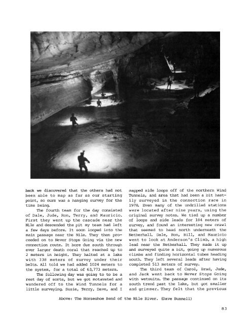
ack we discovered that the others had notbeen able to map as far as our startingpoint, so ours was a hanging survey <strong>for</strong> thetime being.The fourth team <strong>for</strong> the day consistedof Dale, Jude, Ron, Terry, and Mauricio.First they went up the cascade near theNile and descended the pit my team had lefta few days be<strong>for</strong>e. It soon looPed into themain passage near the Nile. They then proceededon to Never Stops Going via the newconnection route. It bore due south throughever larger death coral that reached up to2 meters in height. They halted at a lakewith 338 meters of survey under theirbelts. All told we had added 1024 meters tothe system, <strong>for</strong> a total of 63,773 meters.The following day was going to to be arest day of sorts, but we got motavated andwandered off to the Wind Tunnels <strong>for</strong> alittle surveying. Susie, Terry, Dave, and ImapPed side loops off of the northern WindTunnels, and area that had been a bit hastilysurveyed in the connection race in1978. Even many of the undrilled stationswere located after nine years, using theoriginal survey notes. We tied up a numberof loops and side leads <strong>for</strong> 184 meters ofsurvey, and found an interesting new crawlthat seemed to head north underneath theNetherhalL Dale, Ron, Bill, and Mauriciowent to look at Anderson's Climb, a highlead near the Netherhall. They made it upand surveyed quite a bit, going up numerousclimbs and finding horizontal tubes headingsouth. They left several leads after havingcompleted 513 meters of survey.The third team of Carol, Brad, Jude,and Jack went back to Never Stops Goingwith wetsuits. The passage continued on itssouth trend past the lake, but got smallerand grimmer. They felt that the previousAbove: The Horseshoe Bend of the Nile River.(Dave Bunnell)83