Bridgwater Gateway - Moving Somerset Forward
Bridgwater Gateway - Moving Somerset Forward
Bridgwater Gateway - Moving Somerset Forward

You also want an ePaper? Increase the reach of your titles
YUMPU automatically turns print PDFs into web optimized ePapers that Google loves.
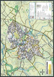
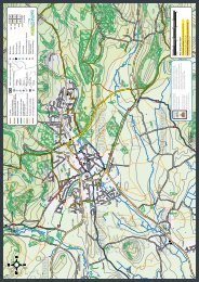
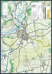
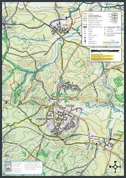
<strong>Bridgwater</strong> <strong>Gateway</strong> Travel Plan2.0 SITE ACCESSIBILITY2.1.1 A full audit has been undertaken of the accessibility of the development siteby all modes of transport to all relevant destinations such as otherworkplaces, residential areas, transport nodes and facilities.2.1.2 This section outlines these linkages in full, using information collected fromthe Transport Assessment. Where deficiencies in the network have beenidentified that mean with the effect of the proposals there will be limitationsarising, remedies are put forward within the Action Plan and Off-SiteImprovements Sections of this Travel Plan to address these deficiencies.2.2 General Situation2.2.1 The site is on the south western boundary of <strong>Bridgwater</strong> approximately2.5km to the south of the town centre as shown at Appendix 1.2.2.2 The A38 bounds the site to the east and provides access to Bristol, Westonsuper-Mareand <strong>Bridgwater</strong> to the north and Taunton to the south. The M5Junction 24 is some 300m to the south east of the A38.2.2.3 The A38 continues some 50m north east of the site to the Huntworthroundabout. The Huntworth Roundabout provides access to a number ofemployment and residential developments as well as M5 Junction 24 via adual carriageway link.2.2.4 The A38 in the vicinity of the site is single carriageway and subject to a40mph speed restriction. The A38 provides access to a number ofresidential dwellings and the Regional Rural Business Centre (RRBC) to thesouth west of the Huntworth Roundabout. The RRBC includes a livestockmarket and dairy distribution centre and is served by a signal junction on tothe A38 to the south of the site.2.2.5 To the north east of the Huntworth roundabout is the Huntworth BusinessPark and motorway services.2.2.6 To the west of the A38 and north of the site is a partly built out residentialurban extension area known as Stockmoor and Wilstock village.2
<strong>Bridgwater</strong> <strong>Gateway</strong> Travel Plan2.3 WalkingWalkingAccessibilityFindingsA footway is provided along the western side of the A38 betweenNorth Petherton to the south and the RRBC junction. Pedestriancrossings are provided at the RRBC junction. Footways then continuenorth along both sides of the A38 however the footway on the westernside stops just south of the site.To the north the footway provision along the A38 continues along theeastern side of the road. Footways are provided on both sides of theA38 from the Showground roundabout north to <strong>Bridgwater</strong>.Footways are provided throughout the Stockmoor village residentialdevelopment immediately north of the site which link to footwayprovision on the A38 at the Showground roundabout.Safety and security Street lighting is provided along the A38.Some of the sections of footway to the south of the site are narrowand uneven.The footway along the A38 between Huntworth roundabout and MoorLane is overgrown. The speed limit on the A38 along this section is60mph with the route being rural in nature.ComfortThe A38 road is heavily trafficked in peak hours.Along the A38 between Huntworth and Showground roundabouts thespeed limit is 60mph.InformationFootways are provided adjacent to the A38 carriageway.2.4 CyclingCyclingAccessibilityFindingsNational Cycle Route 3 (NCN 3) runs between Penzance and Bristoland passes to the north of the site. Access to NCN 3 is via MarshLane some 800 m to the north of the site. From Marsh Lane NCN 3runs on the tow path of the <strong>Bridgwater</strong> and Taunton Canal providing alevel, traffic free cycle route to <strong>Bridgwater</strong> town centre. The route alsoruns along the River Parrett further to the east accessed via a rurallane and stepped bridge over the river. This bridge is connected to theNetwork Rail railway bridge.There are no cycle routes on the A38 Taunton Road immediately tothe north or south of the site.Toucan crossings are provided at the RRBC signal junction with theA38 to the south with advanced cycle stop lines also provided. An offroadcycleway is provided from the A38 junction into the RRBC site.3
<strong>Bridgwater</strong> <strong>Gateway</strong> Travel PlanSafety and securityThere are no dedicated on-road or off-road cycle routes on the A38Taunton Road in the vicinity of the site. The A38 has a 40mph speedlimit in this location.To access the NCN route 3 from the site cycles have to cross theA38.The NCN routes are rural in nature at the Moor Lane end of the routesand secluded. Towards the town centre factories/houses back on theroutes providing improved visibility.ComfortThe roads through Stockmoor village are residential in nature andlightly trafficked providing an alternative route to the A38.From Marsh Lane NCN 3 runs on the tow path of the <strong>Bridgwater</strong> andTaunton Canal providing a level, traffic free cycle route to <strong>Bridgwater</strong>town centre.InformationSignage for the NCN route 4 is provided. Signage is also providedaround the RRBC junction.2.4.1 The <strong>Bridgwater</strong> cycle map produced by <strong>Somerset</strong> County Council isprovided at Appendix 2.2.5 Bus UseBus useAccessibilitySafety and securityComfortInformationFindingsBus stops are provided adjacent and opposite the site with laybys andflags provided.No shelter is provided. Street lighting is provided along the A38 in thevicinity of the stops.No shelter or seating is provided.A clear view of the bus approaching is available in both directions.A flag indicating the location of the bus stops is provided as is the busstop code and traveline contact details for service information.BusesServiceFrequencyof servicesDestinationsTowards<strong>Bridgwater</strong>Firstarr/depLastarr/depTowardsTauntonFirstarr/depLastarr/depFare andjourney times tonearest maindestinationsMonday to Saturday15/15A 30 mins21/21A 30 minsSunday21/21A 2 hoursBurnhamon-SeatoRockwellGreenBurnhamon-SeatoTauntonBurnhamon-seatoTaunton07.30 19.30 06.15 18.1507.08 23.00 06.18 23.1011.17 21.17 10.58 20.58FirstDay £4.00a dayWebberbusEasylink £6.60a dayWeekly/monthlyand annualtickets available4
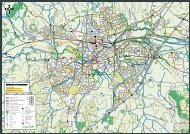
<strong>Bridgwater</strong> <strong>Gateway</strong> Travel Plan2.6 TrainsTrainsAccessibilityFindings<strong>Bridgwater</strong> train station is on St John Street in central <strong>Bridgwater</strong>2.5km to the north of the site. Signage to and from the station andtown centre is provided although could be improved.A local ‘stopping’ train service stops at <strong>Bridgwater</strong> and operatesbetween Bristol and Taunton. Some services also start at Cardiff andothers continue to Exeter and Plymouth. Trains to destinations furtherafield including to London can be caught by changing trains at Bristolor Taunton.Safety and securityComfortInformationAccess to southbound platform from the ticket office is by steps.Level access can be gained by accessing the station from RedgateStreet to the east.Station staff around during the day. Likely to be quiet in the evening.Both platforms have seating which is sheltered. The ticket office alsoprovides shelter inside when open. Toilets are accessible during ticketoffice opening times.Timetables provided by the ticket office. The ticket office is open06.30-14.30 Monday to Saturday. A ticket machine and informationpoint are provided on the platform.TrainsServiceFrequencyof servicesDestinationsFirst arr to<strong>Bridgwater</strong>TowardsCardiffLast depfrom<strong>Bridgwater</strong>TowardsTauntonFirst arr to<strong>Bridgwater</strong>Last depfrom<strong>Bridgwater</strong>Fare andjourney timesto nearest maindestinationsMonday to SaturdayCardiffCentral-TauntonHourlyBristol/Weston-Super-Mare-<strong>Bridgwater</strong>-Taunton andlocal stops onrouteSome trainsalso start atCardiff andsomecontinue toExeter andPlymouth06.03 22.57 05.30 00.01From Taunton12 mins return£7.00From W-S-M19 mins return£7.80From Bristol 50mins approxreturn £14.40Season ticketsavailable.5
<strong>Bridgwater</strong> <strong>Gateway</strong> Travel Plan2.7 DrivingDrivingAccessibilityFindingsThe A38 bounds the site to the east and provides access to Bristol,Weston-super-Mare and <strong>Bridgwater</strong> to the north and Taunton to thesouth.The A38 provides access to a number of residential dwellings and theRegional Rural Business Centre to the south west of the HuntworthRoundabout.Safety and securityInformationThe A38 continues 50m north east of the site to the Huntworthroundabout. The Huntworth Roundabout provides access to a numberof employment and residential developments as well as to M5Junction 24 (300m to the south east of the A38) via a dualcarriageway link.The A38 in the vicinity of the site is single carriageway and subject toa 40mph speed restriction. Street lighting is provided.The speed limit increases to 60mph between Huntworth andStockmoor roundabouts and is then 30mph continuing into<strong>Bridgwater</strong>.Signage to local destinations provided at Huntworth roundabout.2.8 Neighbouring Land Uses and Local Facilities2.8.1 There are a number of employment uses nearby including the HuntworthBusiness Park to the north east and a livestock market and dairy distributioncentre forming part of the Regional Rural Business Centre (RRBC) to thesouth. A café is also provided at RRBC. The RRBC is served by a signalcontrolled junction on the A38.2.8.2 The residential areas of Stockmoor and Wilstock villages, partly built outresidential urban extensions are immediately to the north of the site. NorthPetherton is to the south.2.8.3 The M5 J24 motorway services are 500m to the north east of the centre ofthe site. These include a Burger King fast food outlet, Costa Coffee café,WH Smith newsagent and petrol filling station.2.8.4 Neighbourhood facilities are provided in North Petherton and <strong>Bridgwater</strong>1.5km to the south and 2km to the north respectively.2.8.5 A map indicating the local facilities will be provided as part of the marketingof the site. This map will also include walking, cycling and public transportroutes and information. Further information is provided in Section 3.6