Ward Profile: Yewdale
Ward Profile: Yewdale
Ward Profile: Yewdale

Create successful ePaper yourself
Turn your PDF publications into a flip-book with our unique Google optimized e-Paper software.
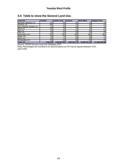
<strong>Yewdale</strong> <strong>Ward</strong> <strong>Profile</strong>5.4 Table to show the General Land Use.Land Use <strong>Yewdale</strong> Carlisle Total Cumbria North West England TotalDomestic_Buildings_m2 11% 0% 0% 1% 1%Gardens_m2 34% 1% 1% 4% 4%Non_Domestic_Buildigs_m2 1% 0% 0% 1% 1%Road_m2 14% 1% 1% 3% 2%Rail_m2 0% 0% 0% 0% 0%Path_m2 1% 0% 0% 0% 0%Greenspace_m2 37% 95% 92% 84% 88%Water_m2 0% 1% 5% 5% 2%Other_m2 2% 1% 0% 2% 1%Unclassified_m2 0% 0% 0% 0% 0%Total_m2 1,547,619 1,040,467,623 7,095,324,774 14,680,742,126 131,926,495,360Source: ODPM General Land Use Database 2001Note: Percentages are rounded to no decimal places so 0% may be figures between 0.0%and 0.49%11