SHLAA Discarded Sites (March 2013) in PDF format - Allerdale ...
SHLAA Discarded Sites (March 2013) in PDF format - Allerdale ...
SHLAA Discarded Sites (March 2013) in PDF format - Allerdale ...
- No tags were found...

You also want an ePaper? Increase the reach of your titles
YUMPU automatically turns print PDFs into web optimized ePapers that Google loves.
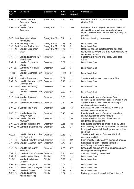
<strong>SHLAA</strong>RefLocation Settlement SiteAreaSiteCapacityCommentsEXRU228 Land to the rear ofBroughton PrimarySchoolEXRU153 Land at GreatBroughtonBroughton 1.84 65 <strong>Discarded</strong> due to current use as a schoolplay<strong>in</strong>g fieldBroughton 4.6 184 <strong>Discarded</strong> due to majority of development ofsite would have adverse visual/landscapeimpact. Development of site frontage may bepossibleBroughton Moor 0.1 3 Site has plann<strong>in</strong>g permissionAARU134 Broughton MoorAllotmentsEXRU226 Plant<strong>in</strong>g Villas Broughton Moor 0.17 6 Less than 0.3haEXRU145 Former Brickworks Broughton Moor 0.27 9 Less than 0.3haEXRU131 Land at BroughtonMoorBroughton Moor 0.34 11 Means of access substandard to supportresidential development. Site poorly related tosettlement patternEXRU01 Land adjacent to 127Ma<strong>in</strong> StreetDearham 0.07 2 Substandard means of access. Less than0.3haEXRU93 Land at Sycamore Dearham 0.08 3 Less than 0.3haLodgeEXRU63 Land opp Mill Brow Dearham 0.08 3 Less than 0.3haHouseRU03 Land at Dearham Row Dearham 0.082 3 Less than 0.3ha(b)EXRU82 land at Dearham Dearham 0.09 3 Substandard access. Less than 0.3haEXRU34 Land to the rear of 1/2 Dearham 0.16 5 Less than 0.3haMaryport RdEXRU195 Land at Bloom<strong>in</strong>g Dearham 0.18 6 Less than 0.3haHeatherRU01 Land at Dearham Row Dearham 0.27 9 Less than 0.3ha(a)EXRU193 Land nr DearhamHouseDearham 0.28 9 Substandard means of access. Poorrelationship to settlement pattern. Under 0.3haAARU90 Land off Central Road Dearham 0.3 10 Substandard access. Poor relationship toexist<strong>in</strong>g settlement patternEXRU213 Land at the Went Dearham 0.38 13 Restricted visibility - satisfactory means ofaccess cannot be achievedAARU87 Land adjacent toPottery ParkDearham 0.43 14 Substandard means of access - could notsupport residential developmentEXRU110 Land to the rear ofWyngarthDearham 0.55 18 Substandard access - could not supportresidential developmentEXRU225 Land at Wilson Farm Dearham 0.55 18 Has outl<strong>in</strong>e plann<strong>in</strong>g permission for 12 unitsEXRU230 Land adj Swallowdene Dearham 0.62 21 Poor visibility - satisfactory standard of accessto support residential development cannot beachievedRU22 Land to the rear of theOld OrchardDearham 0.63 21 Substandard means of access - lack ofadequate visibility.EXRU53 Land adj to Netherwood Dearham 0.66 22 Poor visibility. Substandard means of accessEXRU166 Land at Scheme Farm Dearham 0.73 24 Restricted visibility - unable to obta<strong>in</strong>satisfactory means of accessEXRU56 Land to the rear ofStormontDearham 2.31 87 Inadequate access and poor relationship withexist<strong>in</strong>g settlement patternAARU91 Land adj Croft Crescent Dearham 2.61 98 Site has plann<strong>in</strong>g permissionAARU82 Land at Wood View Flimby 0.06 2 Less than 0.3haRU82 Land adj to M<strong>in</strong>ers Flimby 0.06 2 Less than 0.3haCottageEXRU99 Land at Hallgarth Flimby 0.08 3 Less than 0.3haAARU81 Land at the Fothergills Flimby 0.1 3 Less than 0.3haRU54 Land adj Beldor Flimby 0.17 6 Less than 0.3haAARU85 Land adjacent toRhyhill Farm (a)Flimby 0.32 11 Dra<strong>in</strong>age issues. Lies with<strong>in</strong> Flood Zone 2