PostGIS 1.5.8 Manual - Fedora Project Packages GIT repositories
PostGIS 1.5.8 Manual - Fedora Project Packages GIT repositories
PostGIS 1.5.8 Manual - Fedora Project Packages GIT repositories

You also want an ePaper? Increase the reach of your titles
YUMPU automatically turns print PDFs into web optimized ePapers that Google loves.
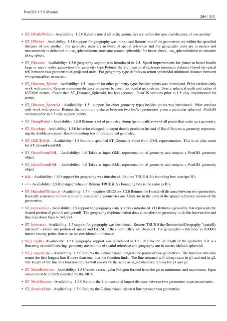
<strong>PostGIS</strong> <strong>1.5.8</strong> <strong>Manual</strong>284 / 310• ST_DFullyWithin - Availability: 1.5.0 Returns true if all of the geometries are within the specified distance of one another• ST_DWithin - Availability: 1.5.0 support for geography was introduced Returns true if the geometries are within the specifieddistance of one another. For geometry units are in those of spatial reference and For geography units are in meters andmeasurement is defaulted to use_spheroid=true (measure around spheroid), for faster check, use_spheroid=false to measurealong sphere.• ST_Distance - Availability: 1.5.0 geography support was introduced in 1.5. Speed improvements for planar to better handlelarge or many vertex geometries For geometry type Returns the 2-dimensional cartesian minimum distance (based on spatialref) between two geometries in projected units. For geography type defaults to return spheroidal minimum distance betweentwo geographies in meters.• ST_Distance_Sphere - Availability: 1.5 - support for other geometry types besides points was introduced. Prior versions onlywork with points. Returns minimum distance in meters between two lon/lat geometries. Uses a spherical earth and radius of6370986 meters. Faster than ST_Distance_Spheroid, but less accurate. <strong>PostGIS</strong> versions prior to 1.5 only implemented forpoints.• ST_Distance_Spheroid - Availability: 1.5 - support for other geometry types besides points was introduced. Prior versionsonly work with points. Returns the minimum distance between two lon/lat geometries given a particular spheroid. <strong>PostGIS</strong>versions prior to 1.5 only support points.• ST_DumpPoints - Availability: 1.5.0 Returns a set of geometry_dump (geom,path) rows of all points that make up a geometry.• ST_Envelope - Availability: 1.5.0 behavior changed to output double precision instead of float4 Returns a geometry representingthe double precision (float8) bounding box of the supplied geometry.• ST_GMLToSQL - Availability: 1.5 Return a specified ST_Geometry value from GML representation. This is an alias namefor ST_GeomFromGML• ST_GeomFromGML - Availability: 1.5 Takes as input GML representation of geometry and outputs a <strong>PostGIS</strong> geometryobject• ST_GeomFromKML - Availability: 1.5 Takes as input KML representation of geometry and outputs a <strong>PostGIS</strong> geometryobject• && - Availability: 1.5.0 support for geography was introduced. Returns TRUE if A’s bounding box overlaps B’s.• ~= - Availability: 1.5.0 changed behavior Returns TRUE if A’s bounding box is the same as B’s.• ST_HausdorffDistance - Availability: 1.5.0 - requires GEOS >= 3.2.0 Returns the Hausdorff distance between two geometries.Basically a measure of how similar or dissimilar 2 geometries are. Units are in the units of the spatial reference system of thegeometries.• ST_Intersection - Availability: 1.5 support for geography data type was introduced. (T) Returns a geometry that represents theshared portion of geomA and geomB. The geography implementation does a transform to geometry to do the intersection andthen transform back to WGS84.• ST_Intersects - Availability: 1.5 support for geography was introduced. Returns TRUE if the Geometries/Geography "spatiallyintersect" - (share any portion of space) and FALSE if they don’t (they are Disjoint). For geography -- tolerance is 0.00001meters (so any points that close are considered to intersect)• ST_Length - Availability: 1.5.0 geography support was introduced in 1.5. Returns the 2d length of the geometry if it is alinestring or multilinestring. geometry are in units of spatial reference and geography are in meters (default spheroid)• ST_LongestLine - Availability: 1.5.0 Returns the 2-dimensional longest line points of two geometries. The function will onlyreturn the first longest line if more than one, that the function finds. The line returned will always start in g1 and end in g2.The length of the line this function returns will always be the same as st_maxdistance returns for g1 and g2.• ST_MakeEnvelope - Availability: 1.5 Creates a rectangular Polygon formed from the given minimums and maximums. Inputvalues must be in SRS specified by the SRID.• ST_MaxDistance - Availability: 1.5.0 Returns the 2-dimensional largest distance between two geometries in projected units.• ST_ShortestLine - Availability: 1.5.0 Returns the 2-dimensional shortest line between two geometries