Landscape structure indices for assessing urban ecological networks
Landscape structure indices for assessing urban ecological networks
Landscape structure indices for assessing urban ecological networks

You also want an ePaper? Increase the reach of your titles
YUMPU automatically turns print PDFs into web optimized ePapers that Google loves.
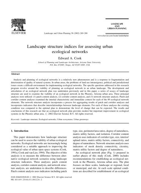
<strong>Landscape</strong> and Urban Planning 58 (2002) 269–280<strong>Landscape</strong> <strong>structure</strong> <strong>indices</strong> <strong>for</strong> <strong>assessing</strong> <strong>urban</strong><strong>ecological</strong> <strong>networks</strong>Edward A. CookSchool of Planning and <strong>Landscape</strong> Architecture, Arizona State University,P.O. Box 872005, Tempe, AZ 85287-2005, USAAbstractAnalysis and planning of <strong>ecological</strong> <strong>networks</strong> is a relatively new phenomenon and is a response to fragmentation anddeterioration of quality of natural systems. In <strong>urban</strong> areas, the problems of land use intransigence, political and jurisdictionalissues create a difficult environment <strong>for</strong> implementing <strong>ecological</strong> <strong>networks</strong>. The specific questions addressed in this researchprogram revolve around the viability of planning an <strong>ecological</strong> network in an <strong>urban</strong> landscape. The development andarticulation of an <strong>ecological</strong> network plan was undertaken previously and in this paper, a series of assays of landscape<strong>structure</strong> are used to examine the viability of an <strong>ecological</strong> network in the Phoenix, Arizona <strong>urban</strong> area. Three principalanalyses were utilized: (1) patch content analysis, (2) corridor content analysis, and (3) network <strong>structure</strong> analysis. Patch andcorridor content analyses examined the internal characteristic and immediate context <strong>for</strong> each of the 89 <strong>ecological</strong> networkelements. The network <strong>structure</strong> analysis incorporates a process <strong>for</strong> aggregating results of patch and corridor analyses andincorporates indicators that describe interrelationships between landscape elements. For each of these analyses the existingcondition was compared to the optimal plan to demonstrate the level of change that can be expected. The results andconclusions of this research are that an <strong>ecological</strong> network plan provides modest but important improvement in <strong>ecological</strong>systems in the Phoenix <strong>urban</strong> area. # 2002 Elsevier Science B.V. All rights reserved.Keywords: <strong>Landscape</strong> <strong>structure</strong>; Ecological <strong>networks</strong>; Urban ecosystems; Urban greenways1. IntroductionThis paper demonstrates how landscape <strong>structure</strong>can be used to assess the viability of <strong>urban</strong> <strong>ecological</strong><strong>networks</strong>. Ecological <strong>networks</strong> are increasingly beingconsidered as a suitable approach to improving the<strong>ecological</strong> value of <strong>urban</strong> open space systems (Cook,1991a; Cook and van Lier, 1994). The objective of thisanalysis is to measure the difference between alternative<strong>ecological</strong> network scenarios using landscape<strong>structure</strong> indicators. Three analyses; patch contentanalysis, corridor content analysis, and network <strong>structure</strong>analysis, are undertaken to describe differences.Patch content analysis uses indicators including patchtype, size, perimeter/area ratios, degree of naturalness,matrix utility factors, and isolation. Corridor contentanalysis uses indicators of corridor type, size, interior/upland ratios, matrix utility factors, connectivity, anddegree of naturalness. Network <strong>structure</strong> analysis usesindicators of mesh density connectivity, circuitry,matrix utility factors and degree of naturalness.An <strong>ecological</strong> network plan (Fig. 1) prepared inearlier phases of this study (Cook, 2000) includesrecommendations <strong>for</strong> establishing an <strong>ecological</strong> networkin the Phoenix, Arizona <strong>urban</strong> area. The planfocuses on three scales, landscape or regional, localor municipal, and site. At each scale optimal conditionsare described <strong>for</strong> establishment of an <strong>ecological</strong>0169-2046/02/$20.00 # 2002 Elsevier Science B.V. All rights reserved.PII: S 0169-2046(01)00226-2
270 E.A. Cook / <strong>Landscape</strong> and Urban Planning 58 (2002) 269–280Fig. 1. Patches and corridors and landscape scale.network. The plan is designed to enhance the overall<strong>ecological</strong> viability of the study area by reducingfragmentation, maintaining naturalness, and improvingcompatibility of the landscape matrix with the<strong>ecological</strong> network. The analysis demonstrates thatthe <strong>ecological</strong> network plan provides notable improvementover the current situation and managementschemes.2. Criteria <strong>for</strong> <strong>assessing</strong> viabilityAssessment of <strong>ecological</strong> network viability can beundertaken by analyzing the inherent characteristicsof the landscape elements, the interrelationshipsbetween landscape elements and external factorsaffecting the functioning of the <strong>ecological</strong> network.A range of landscape element attributes are assessedthrough patch and corridor content analysis. Inherentcharacteristics include size and type, vegetative<strong>structure</strong> and diversity, and naturalness. Interrelationshipsbetween individual landscape elements and thelandscape matrix are assessed through a number ofindicators that are described as context. Network<strong>structure</strong> analysis considers the overall effect of theinterrelationship of patches and corridors within thecontext of the <strong>urban</strong> matrix. The network <strong>structure</strong>analysis includes mesh density, circuitry and connectivity.This process is undertaken using plans describedin previous studies <strong>for</strong> the Phoenix <strong>urban</strong>area, principally at landscape scale. Both the existingsituation and an optimal situation are assessed.2.1. Patch content analysisThe patch content analysis incorporates four principlevariables, (1) patch size and type, (2) vegetative<strong>structure</strong> and diversity, (3) patch context, and (4) patchnaturalness. Each variable has several sub-variables orattributes that are used to describe and assess patch
E.A. Cook / <strong>Landscape</strong> and Urban Planning 58 (2002) 269–280 271Table 1Summary of patch content analysisPatch size and typeOrigin 17 Natural 18 CulturalType 17 Remnant 18 IntroducedArea (mean)4650 haPerimeter length (mean) 22051 mPerimeter/area ratio (mean) 1.48Patch vegetative <strong>structure</strong> and diversityVegetative cover (mean) 0.33Native cover (mean) 0.17Structural diversity (mean) 0.62Total vegetation value (mean) 1.17Patch contextMatrix utility (mean) 0.59Isolation index (mean) 1.51T-links (mean)1.23 (43 Total)Patch naturalnessNative vegetation (mean) 0.17Soils (mean) 0.42Flows (mean) 0.35Total naturalness0.94value (mean)characteristics. Each of the patches were analyzedusing these variables. A summary of the results ofthe patch content analysis is included in Table 1.2.1.1. Patch size and typePatch size and type have been shown to affectinteractions of wildlife and affect <strong>ecological</strong> value.Forman (1995) uses five terms to classify patches,primarily based on origin and function. A remnantpatch is one that is left in its original characterfollowing widespread dist<strong>urban</strong>ce that changes thesurrounding matrix. A regenerated patch has beenpreviously disturbed or changed and has since naturallyreestablished vegetative cover. An introducedpatch is similar to a regenerated patch in that it waspreviously disturbed, but the establishment of newvegetation is of human origin. An environmental patchis one that exists within a predominantly naturalcontext and has significant natural values, but differsfrom the surrounding matrix. A dist<strong>urban</strong>ce patchis established by local dist<strong>urban</strong>ce of an area thatchanges the character, resulting in a patch that differsfrom its surroundings.The size of patches also affects their viability and<strong>ecological</strong> value. Large patches are more valuablebecause they support large, persistent populations.Thus, there is a relationship between patch area andwildlifeabundance,persistenceanddiversity(Duerksonet al., 1997). Numerous researchers have demonstratedthis species area relationship. Large patchespreserve greater areas of interior habitat which isbeneficial to many indigenous species that are nottolerant of edge habitats. Smaller patches have moreedge area. Forman (1995, p. 47) lists <strong>ecological</strong> valuesof large and small patches.Large patches:1. Water quality protection <strong>for</strong> aquifer and lake.2. Connectivity of a low-order stream network <strong>for</strong>fish and overland movement.3. Habitat to sustain populations of patch interiorspecies.4. Core habitat and escape cover <strong>for</strong> large-homerangevertebrates.5. Source of species dispersing through the matrix.6. Microhabitat proximities <strong>for</strong> multihabitat species.7. Near-natural dist<strong>urban</strong>ce regimes at where manyspecies evolved with and require dist<strong>urban</strong>ce.8. Buffer against extinction during environmentalchange.Small patches:1. Habitat and stepping stones <strong>for</strong> species dispersal,and <strong>for</strong> recolonization after local extinction ofinterior species.2. High species densities and high population sizesof edge species.3. Matrix heterogeneity that decreases fetch (run)and erosion, and provides escape cover frompredators.4. Habitat <strong>for</strong> small-patch-restricted species. Occasionalexamples are known of species that do notpersist in larger patches.5. Protect scattered small habitats and rare species.The bottom line: large patches, large benefits, andsmall patches, small supplemental benefits.Three measures of patch size and type are used toevaluate the various attributes of patches within thissystem; patch area, perimeter length and perimeter/area ratio. Patch area is a simple measurement ofthe patch area in hectares and, with other factors,may be a good measure of long term viability of apatch. Perimeter length is used in combination with
272 E.A. Cook / <strong>Landscape</strong> and Urban Planning 58 (2002) 269–280patch area to calculate the perimeter/area ratio. Perimeter/arearatio describes the relationship betweenpatch area and boundary length and provides usefulin<strong>for</strong>mation about the potential edge effect that may bepresent in a specific patch. Perimeter/area is a simpleratio and is calculated using the following <strong>for</strong>mula:D i ¼ pP2 ffiffiffiffiffiffiApwhere D i is the perimeter area ratio <strong>for</strong> patch i (alsoreferred to as patch shape index); P the perimeter ofthe patch; A the area of the patch.2.1.2. Vegetative <strong>structure</strong> and diversityVegetative <strong>structure</strong> and diversity is described usingthree principle attributes that provide some considerationof the inherent qualities of the vegetation of eachpatch. Included in this analysis are net percent areacovered by vegetation or vegetative cover, percentnative vegetation, and vegetative structural diversity.Vegetative cover is one factor that contributes to the<strong>ecological</strong> health and can be used as wildlife habitat(Matthews et al., 1988). Forman (1995) notes thatplant growth (or biomass, the overall weight of livingtissue) is an attribute that can be measured as anindicator of productivity, one of four componentsForman believes can be used as a measure of <strong>ecological</strong>integrity. Vegetative cover was calculated <strong>for</strong>each patch using aerial photographs and field inventory.Multiple layers manifested as vertical stratificationis another indicator of habitat value in particular.Overlap of vegetation is not measured in the computationof coverage. Alone, net area covered by vegetationis not sufficient to fully evaluate the vegetative<strong>structure</strong>. In <strong>urban</strong> areas, vegetation often consistslargely of exotic species and while these may providemany <strong>ecological</strong> benefits, exotic species are usuallynot as important to native wildlife species as habitat.Hence, percent of vegetation in each patch that isindigenous is an indicator of <strong>ecological</strong> value. Nativevegetation (Kearney and Peebles, 1960) coverage wascalculated <strong>for</strong> each patch as a percentage of total patcharea (Shaw et al., 1998). Representative patches weresampled <strong>for</strong> each type and values applied over similarpatch types.Structural diversity is another vegetation attributethat is an indication of <strong>ecological</strong> value. Verticalstratification of vegetation is manifested in the <strong>for</strong>mof tree canopy, shrub layer and ground cover. Structuraldiversity gives more possibilities <strong>for</strong> greaterdiversity of habitat types, yielding increased diversityand greater possibilities <strong>for</strong> species survival. Smallmammals, lizards and birds will use shrub layers asescape cover, while insects may be more reliant uponground cover. Evaluation of structural diversity wasaccomplished by <strong>assessing</strong> the area covered by eachlayer. In this assessment, overlap of vegetative layerswas included, potentially yielding a value of 3.0.Sampling occurred in a representative patch <strong>for</strong> eachtype.2.1.3. Patch contextSeveral external attributes can also be used todescribe a patch and affect its <strong>ecological</strong> value. Manyexternal factors can make a patch more or less <strong>ecological</strong>lyviable. These are analyzed with relation tothe effect on each patch. Cumulative effects of externalfactors are analyzed later in the network <strong>structure</strong>analysis. Important considerations include the compatibilityof the matrix (matrix utility) adjacent to thepatch, the isolation of the patch and accessibility of thepatch (T-links). Matrix utility refers to the extentspecies may utilize the landscape adjacent to andimmediately surrounding patch boundaries. An idealcondition is <strong>for</strong> a patch to be buffered with compatibleland use types and vegetation. The absence of asuitable buffer of compatible land uses effectivelyincreases the edge effect and reduces the interior orcore area of a patch. Conditions that change the matrixutility value are intense land uses, significant humanimpact, absence of vegetation (in particular indigenousvegetation), presence of pollutants of toxic materials,and domestic predators (cats, dogs, etc.). Matrixutility is indexed on a scale in which a wholly compatibleadjacent matrix landscape is valued at 1 andwholly incompatible matrix is 0. Matrix utility iscalculated by measuring percent adjacent land useof the patch perimeter multiplied by the land useintensity factor.M ¼ X a i u iwhere M is the matrix utility index of patch; a thepercentage of perimeter of land use i; u the intensityvalue of land use i.Patch isolation is a function of the proximity ofpatches or corridors within a landscape mosaic. While
E.A. Cook / <strong>Landscape</strong> and Urban Planning 58 (2002) 269–280 273connectivity is measured among a series of landscapeelements, isolation addresses the connectivity or lackof connectivity of an individual patch. It is simply anindex of the distance between patches and the numberof neighboring patches. Isolation is calculated usingthe following <strong>for</strong>mula (Bowen and Burgess, 1981).R i ¼ 1 nXdijwhere R i is the isolation index of the patch; n thenumber of neighboring patches considered and d ij isthe distance between patch i and any neighboringpatch j.Accessibility is a simple measure of the number ofphysical connections (described here as T-links) ofcorridors or patches included within the <strong>ecological</strong>network.2.1.4. Naturalness indexPatch naturalness is essentially a function of theabsence of human impact and is a measure of variabilityfrom the original <strong>ecological</strong> system. Indicatorsof human impact include the presence of exotic species,soil compaction or extent of paving, disruption offlow and function, disconnection from original locationand <strong>for</strong>m. Presence of native vegetation species asan indicator was discussed in the section on vegetative<strong>structure</strong> and diversity. In the absence of extensivebiological wildlife surveys, known habitat preferences,threatened, rare or endangered species are used.Soil compaction and extent of pavement providesin<strong>for</strong>mation concerning a patch’s fundamental nutrientcycles. Compacted soils, pavement or areas of soilerosion are unproductive and cause secondary problemssuch as increased runoff, loss of nutrients andminerals and increased sediment in streams, reducingwater quality. Disruption of flows and functions can beassessed using landscape <strong>structure</strong> by comparing originaland current condition of movement of air, waterand species. Disturbed streams, migration corridorsand presence of barriers are all examples of ways flowsand function are disrupted.2.2. Corridor content analysisThe viability of corridors is assessed using similarlandscape <strong>structure</strong> indicators as with patches. Thedifferent types of corridors can be described using thesame five terms Forman (1995) uses to classifypatches, based primarily on origin and function; remnant,regenerated, introduced, environmental and dist<strong>urban</strong>ce.A remnant corridor is typically one that is aleft over strip after a widespread dist<strong>urban</strong>ce. Aregenerated corridor has evolved naturally followingsome other use or <strong>for</strong>m, such as a hedgerow that hasevolved naturally. Corridor’s functions include habitat,conduit, filter, source and sink (Forman, 1995).These basic functions can be further articulated ascontributors to a range of more specific goals. Biologicaldiversity is enhanced through the preservationand restoration of riparian corridors that are criticalhabitat and important dispersal routes <strong>for</strong> species.Water resource management including flood controlerosion control and water quality are facilitated indrainage corridors. Agro<strong>for</strong>estry production isenhanced with windbreak corridors that also help tocontrol erosion. Recreational activities typically occurin corridors such as hiking, game management, bicyclingand greenbelts. Important attributes include sizeand type, vegetative <strong>structure</strong> and diversity, corridorcontext and naturalness. A summary of the results ofthe corridor content analysis in included in Table 2.2.2.1. Corridor size and typeCorridor size and type affects the five basic functions(Forman, 1995) in various ways. Two principalcharacteristics of width indicate how well a corridormay accommodate these functions. The internal areais important to accommodate stream flows, as conduit<strong>for</strong> species migration, as source pool, and as sink,controlling erosion nutrient runoff, sedimentation andflooding. In addition, the upland zone of a corridormay per<strong>for</strong>m many of the same <strong>ecological</strong> functionsbut also filtering and buffering. In <strong>urban</strong> matrices,the filter and buffer function is essential to maintainthe usability of the internal entities. Dramstad et al.(1996) note that 2nd–4th order stream corridors shouldmaintain upland habitat on both sides, enough tocontrol dissolved-substance inputs from the matrix.This also provides conduit <strong>for</strong> interior species andsuitable habitat <strong>for</strong> flood plain species displaced duringflood events. For larger corridors such as rivers of5th–10th order, Dramstad et al. (1996) recommendupland zones on both sides, but also a ladder pattern oflarger patches crossing the flood plain. This <strong>structure</strong>provides a hydrologic sponge that traps sediment,
274 E.A. Cook / <strong>Landscape</strong> and Urban Planning 58 (2002) 269–280Table 2Summary of corridor content analysisCorridor size and typeOrigin 15 Natural 17 CulturalType15 Environmental 17 IntroducedLength (mean)28792 mAverage width (mean) 245 mAverage interior0.58width (mean)Average filter0.11width (mean)Area (mean)1079 haCorridor vegetative <strong>structure</strong> and diversityVegetative cover (mean) 0.20Native cover (mean) 0.16Structural diversity (mean) 0.35Total vegetation0.71value (mean)Corridor contextMatrix utility (mean) 0.56Diversity gradient (mean) 86.40 mT-gaps (mean)1.84 (59 Total)Longest continuous 18870 mdistance (mean)Link segments (mean) 2.78 (89 Total)Corridor naturalnessNative vegetation (mean) 0.16Soils (mean) 0.37Flows (mean) 0.40Total naturalness0.93value (mean)provides nutrients and habitat <strong>for</strong> flood plain species.Forman (1995) notes that, overall, wider corridors arebetter and will enhance all five functions of habitat,conduit, filter, source and sink. He also notes thatresearch is still needed to determine how wide acorridor needs to be to function effectively. Oneimportant indicator is known and that is that a corridorshould be wide enough to accommodate an uplandzone of vegetation to control and filter runoff.2.2.2. Vegetative <strong>structure</strong> and diversityInternal <strong>structure</strong> of corridors has been discussed tosome extent in the section describing patch <strong>structure</strong>and also in this section on corridors. One importantdistinction that can be made concerning the internal<strong>structure</strong> of corridors is that this attribute is one ofseveral that is critical to improve connectivity ofcorridors. The presence of interior entities (i.e. water,flood plains, native vegetation, etc.) improves theconnectivity value of a corridor. The physical <strong>structure</strong>of the upland zone is also important in that it contributesto the viability of the interior as well asproviding buffer and filter functions. The type, structuraldiversity and preponderance of vegetative coverare used as an indicator and measured <strong>for</strong> each corridor.2.2.3. Corridor contextExternal characteristics of corridors are examinedin a similar manner to those of patches. Matrix utilityvalues are assigned according to intensity of theadjacent land uses along the corridor. Corridors thattraverse different habitat zones have potential to functionas important conduits <strong>for</strong> many species. Ascorridors (principally riparian corridors) traverse thelandscape through the upper reaches of a watershedto the lower elevations where they converge and <strong>for</strong>mrivers and streams, they pass through a variety ofecosystem types. Thus, there is great potential <strong>for</strong>increased diversity, transmission of nutrients and continualexchange. Most often this condition yieldsgreater <strong>ecological</strong> health. This condition is a diversitygradient and is another indication of the relative<strong>ecological</strong> value of a corridor. Values are assigned<strong>for</strong> the purpose of this study according to the elevationchange within the reach of the corridor that falls withinthis study area.Continuity is a factor that when combined withothers provide an indication of overall connectivityof a corridor. The presence or absence of gaps in acorridor can be evaluated to assess the continuitypresent in a corridor. In <strong>urban</strong> areas, continuity is oftenbroken by roads, channel reconfiguration or filling, orsimply by dist<strong>urban</strong>ce or human impact resultingfrom use or abuse. Particularly <strong>for</strong> those species thatare exclusively terrestrial, gaps in a corridor representsignificant barriers to migration and other importantfunctions. Each corridor is examined and a continuityvalue is assigned corresponding with the presence ofgaps or barriers in the corridor. In the network analysis,the concept of continuity is extended and a measurementof connectivity is computed.2.2.4. Naturalness indexThe naturalness index <strong>for</strong> corridors uses the sameindicators as patches; native species, soils and flows.
E.A. Cook / <strong>Landscape</strong> and Urban Planning 58 (2002) 269–280 275With stream or river corridors in particular, soil erosionand disruption of flows are very important factors.Because of the intermittent nature of many arid regionriver and stream corridors, extreme hydrologic eventsoccur frequently and significantly change the <strong>structure</strong>of a channel. While these events may be of naturalorigin, the increases in runoff within watersheds due to<strong>urban</strong>ization, soil compaction and encroachment onflood plains exacerbates problems and rapidly reducesthe natural character of the corridor and the functionsthat occur within.2.3. Network <strong>structure</strong> analysisThe analysis of patch and corridor content is onlysignificant at the landscape scale if data are integratedinto a larger more comprehensive analysis. Network<strong>structure</strong> analysis introduces a process <strong>for</strong> aggregatingresults of patch and corridor analysis and incorporatesindicators that describe interrelationships betweenlandscape elements. The collection of these elements<strong>for</strong>ms the whole landscape mosaic and as patches andcorridors connect and intersect, they <strong>for</strong>m a network ofpotentially high value elements in which <strong>ecological</strong>functions are preserved and/or restored. Several factorscontribute to making an <strong>ecological</strong> network moreviable. In <strong>urban</strong> landscapes, the competition of variousland uses and exotic species is intense. Fragmentationand isolation contribute to deterioration of <strong>ecological</strong>functions and ultimately decline in native species.Thus, establishing or maintaining linkage betweenpatches and corridors is essential to facilitate <strong>ecological</strong>functions. Two factors largely contribute to thesuccessful <strong>ecological</strong> functioning of a network: (1) theoverall density of suitable patches and corridors and(2) the extent to which they are linked.2.3.1. Mesh density/naturalness indexThe density of suitable patches and corridors ismeasured through mesh density analysis. Mesh densityhas three factors that are analyzed: (1) the actualnet area covered by patches and corridors in thenetwork, (2) the matrix utility as related to thosepatches and corridors, and (3) the relative quality ofpatches and corridors. The net area covered is computedby calculating the area occupied by networkelements within the study area or within a particularsector. This is described as percent net density of theTable 3Mesh density/naturalness indexArea (ha)Totalarea (%)Natural patch 161137.00 0.22 1.79Cultural patch 1632.00 0.00 0.15Natural corridor 30490.00 0.04 1.98Cultural corridor 4047.00 0.01 0.02Total 197306.00 0.27Study area 739218.00 1.00Naturalnessvaluetotal area. The greater the value, the more area that isavailable where <strong>ecological</strong> functions can occur. Themesh density/naturalness index is described in Table 3.2.3.2. Matrix utility indexMatrix utility has been discussed previously in thesections describing patch and corridor content analysis.The values computed <strong>for</strong> each patch and corridor areaggregated and averaged <strong>for</strong> an overall matrix utilityvalue. The relative quality of patches and corridorsrefers to the patch and corridor content analysis indicatorsof naturalness, vegetation, type and size. Thesevalues are also aggregated and averaged to assess overallnetwork quality and are summarized in Table 4.2.3.3. Circuitry and connectivityThe linkage of various elements within the networkcan be explained with the concepts of circuitry andconnectivity. Network circuitry is described as theextent to which loops or circuits are present in thenetwork. The ‘‘alpha index <strong>for</strong> circuitry’’ measures thenumber of loops present divided by the maximumnumber of loops possible. Loops are importantbecause they provide alternative migration routes<strong>for</strong> organisms that may need to avoid dist<strong>urban</strong>cesor predators. Circuitry is measured using the followingTable 4Matrix utility indexArea (ha)Totalarea (%)MatrixutilityNatural patch 161137.00 0.22 0.72 0.16Cultural patch 1632.00 0.00 0.47 0.00Natural corridor 30490.00 0.04 0.73 0.03Cultural corridor 4047.00 0.01 0.54 0.00Total 197306.00 0.27 0.19Study area 739218.00 1.00Area matrixutility
276 E.A. Cook / <strong>Landscape</strong> and Urban Planning 58 (2002) 269–280<strong>for</strong>mula (Hagget et al., 1977; Taafe and Garthier,1973; Forman and Godron, 1986)a ¼ L V þ 12V 5where a is the degree of network circuitry; L thenumber of linkages; V the number of nodes.The results of the circuitry analysis of the existingsituation yielded the presence of 43 nodes (V) and 75links (L) <strong>for</strong> a circuitry value of 0.39.Connectivity is a measure of the extent to which allnodes are connected. As in previous discussions ofnaturalness and the preference <strong>for</strong> native species, twotypes of connectivity may exist. Natural connectivityutilizes existing or restored naturally originated corridorsyielding potentially greater <strong>ecological</strong> benefits.Artificial connectivity is achieved through establishmentof culturally derived corridors and in most cases<strong>ecological</strong> benefits will be less when compared to anatural corridor of similar characteristics. In <strong>urban</strong>areas, utilization of artificial connectivity may be anessential dimension of a network. Since many naturalcorridors are likely to have been removed or destroyed,supplemental connections can be achieved throughproper design of artificial corridors. Together, the alphaindex of circuitry and the gamma index of connectivitydescribe the level of network complexity (Forman andGodron, 1986) and provides an overall index of theeffectiveness of linkages (Dramstad et al., 1996).The ‘‘gamma index of connectivity’’ is the ratio ofthe number of links in a network to the maximumnumber of links possible. The number of links presentand the number of nodes are totaled from the networkand applied in the following <strong>for</strong>mula (Lowe andMoryadas, 1975; Hagget et al., 1977; Sugihara andMay, 1990; Forman and Godron, 1986)Lg ¼3ðV 2Þ ðSÞwhere g is the gamma index of connectivity; L thenumber of linkages; V the number of nodes; S the linksuitability factor.For the purposes of this analysis, another factor wasadded, that of link suitability. This factor is an adjustment<strong>for</strong> corridor naturalness. In an <strong>urban</strong> context, thepotential <strong>for</strong> migration is significantly affected by thepresence of suitable vegetative cover and the absenceof human impact.The results of the connectivity analysis of theexisting situation yielded the presence of 43 nodes(V), 89 links (L) and a link suitability value of 0.31 <strong>for</strong>a connectivity value of 0.22.2.4. Summary of existing situation analysisThe existing landscape mosaic of the Phoenixmetropolitan area has a range of open space elementsof varying <strong>ecological</strong> value. Many of the remnantpatches and corridors have only recently becomedisconnected from the supporting landscape <strong>structure</strong>.Soule (1991) notes, however, that as isolated fragmentsage, the number of species decline and overall<strong>ecological</strong> health deteriorates. The existing conditionanalysis assumes that current land use and landscapemanagement practices will continue. No plan <strong>for</strong>reestablishing connections or improvement of vegetativecover is put into effect. In essence, the status quoreigns. The indicator values outlined in Tables 1–4 <strong>for</strong>patch content analysis, corridor content analysis andnetwork <strong>structure</strong> analysis summarize this currentcondition.2.5. Summary of analysis of optimal conditionThe implementation of an <strong>ecological</strong> network plancan yield changes in the overall <strong>ecological</strong> value. Thisanalysis builds upon the same existing patch andcorridor elements that are present in the Phoenixmetropolitan area (Fig. 1), but employs a series ofmanagement, preservation or restoration strategies toimprove the <strong>ecological</strong> value. This situation is viewedas a system or a comprehensive <strong>ecological</strong> network.Specific recommendations are assumed to be implementedthroughout the network on an individual patchor corridor basis.The examples of site improvement strategiesdescribed in the <strong>ecological</strong> network plan (Cook,2000) are typical of the types of strategies that couldbe employed. These include actions such as revegetationof disturbed sites, creating artificial or syntheticcorridors or patches, expanding buffers by extensifyingadjacent land uses, and others. Based on thesestrategies adjusted patch content, corridor contentand network <strong>structure</strong> analyses are undertaken and asummary is displayed in Tables 5–8. The changedvalues are noted in bold in each case representing the
E.A. Cook / <strong>Landscape</strong> and Urban Planning 58 (2002) 269–280 277Table 5Summary of patch content analysis (optimal) aPatch size and typeOrigin 17 Natural 18 CulturalType 17 Remnant 18 IntroducedArea (mean)4650 haPerimeter length (mean) 22051 mPerimeter/area ratio (mean) 1.48Patch vegetative <strong>structure</strong> and diversityVegetative cover (mean) 0.38Native cover (mean) 0.27Structural diversity (mean) 0.62Total vegetation value (mean) 1.27Patch contextMatrix utility (mean) 0.73Isolation index (mean) 1.51T-links (mean)1.23 (43 Total)Patch naturalnessNative vegetation (mean) 0.27Soils (mean) 0.59Flows (mean) 0.53Total naturalness1.39value (mean)a Values in bold represent the increased <strong>ecological</strong> value in theoptimal condition plan.increased <strong>ecological</strong> value in the optimal conditionplan.2.5.1. Optimal plan patch adjustmentsFor the purpose of this study, patch size and typewere not adjusted <strong>for</strong> the optimal plan. Significantimprovement in <strong>ecological</strong> values can, however, occurwith enlargement of patch size or reduction of perimeterarea ratios to increase interior or core areas.Although, the scope of this study did not address thisstrategy, it should be a part of any <strong>ecological</strong> networkplan where feasible.Optimal patch vegetative <strong>structure</strong> and diversityvalues are adjusted by introducing native vegetationin patches, principally where it is absent in cultivatedparks. A site study focusing on the Indian Bend WashPark (Merkle et al., 1996) (an existing linear park inScottsdale, AZ), demonstrates that in cultivated <strong>urban</strong>parks approximately 50% of the area currently coveredby exotic vegetation could be converted to nativespecies with no significant loss of traditional parkfunctions. The resulting adjustment increases themean native vegetation coverage <strong>for</strong> patches from0.17 to 0.27.Table 6Summary of corridor content analysis (optimal) aCorridor size and typeOrigin 15 Natural 17 CulturalType15 Environmental 17 IntroducedLength (mean) 28792 mAverage width (mean) 245 mAverage interior0.58width (mean)Average filter0.30width (mean)Area (mean)1079 haCorridor vegetative <strong>structure</strong> and diversityVegetative cover (mean) 0.27Native cover (mean) 0.25Structural diversity (mean) 0.48Total vegetation1.00value (mean)Corridor contextMatrix utility (mean) 0.77Diversity gradient (mean) 86.40 mT-gaps (mean)0 (0 Total)Longest continuous 18870 mdistance (mean)Link segments (mean) 2.78 (89 Total)Corridor naturalnessNative vegetation (mean) 0.25Soils (mean) 0.60Flows (mean) 0.62Total naturalness1.47value (mean)a See footnote to Table 5 <strong>for</strong> explanation of values in bold.Optimal patch context values are adjusted byincreasing native vegetation plantings in land usesadjacent to existing patches improving matrix utilityvalues. Increase in matrix utility value, in effect, helpsestablish a more significant buffer external to theboundaries of the patch. In turn, the negative aspectsTable 7Mesh density/naturalness index (optimal) aArea (ha) Total area (%) Natural valueNatural patch 161137.00 0.22 1.79Cultural patch 1632.00 0.00 1.01Natural corridor 30490.00 0.04 2.03Cultural corridor 4047.00 0.01 0.97Total 197306.00 0.27Study area 739218.00 1.00a See footnote to Table 5 <strong>for</strong> explanation of values in bold.
278 E.A. Cook / <strong>Landscape</strong> and Urban Planning 58 (2002) 269–280Table 8Matrix utility index (optimal) aAreaTotalarea (%)MatrixutilityNatural patch 161137.00 0.22 0.82 0.18Cultural patch 1632.00 0.00 0.64 0.00Natural corridor 30490.00 0.04 0.84 0.03Cultural corridor 4047.00 0.01 0.70 0.00Total 197306.00 0.27 0.22Study area 739218.00 1Area matrixutilitya See footnote to Table 5 <strong>for</strong> explanation of values in bold.of edge effect (i.e. loss of interior or core habitat areaof patches) is reduced. The site study <strong>for</strong> DobsonRanch residential community (Brenda et al., 1997),illustrates how existing land uses can be ‘‘extensified’’to make them more usable as habitat and <strong>for</strong> other<strong>ecological</strong> functions. The adjustment is an increase inmatrix utility values from the existing condition (0.59)to the optimal (0.73) of 14%. As with delimitationsnoted concerning patch size and type, context indicatorssuch as isolation and terrestrial links can beimproved by adding more usable patches or corridorsto the network. This was beyond the scope of thisstudy.Optimal patch naturalness adjustments includeincrease in area covered by native vegetation, reductionof area with paving, compacted or eroded soils,and site adjustments to improve flows (i.e. removal ofobstructions or barriers) to return site functions to amore natural condition. Adjustments, as with thoseprevious, are generally confined to cultivated patchessince natural patches have retained much of theiroriginal condition. Adjustments <strong>for</strong> native vegetationare reflective of those noted previously. Soils adjustmentsare introduced by specific improvements to siteconditions, principally by eliminating or reducingpaving where feasible or managing parks and othersites to limit the areas where soil becomes compacteddue to excessive use. The increase in the mean of soilsvalues is 0.17 (0.42–0.59) and is linked to the introductionof native vegetation in areas currently in amore cultivated condition. Flows are improved incultivated patches by reconnecting severed links ordrainage corridors or providing alternatives <strong>for</strong> movementof water, air, nutrients and other elements. Thisis also accomplished through cultivated park siteredesign (Merkle et al., 1996). Overall, patch naturalnessvalues increase from 0.94 to 1.39.2.5.2. Optimal plan corridor adjustmentsAs with patches, the overall size and type of corridorshave not been adjusted <strong>for</strong> this study. Optimalcorridor size and type, also includes data concerningcorridor interior and filter widths. Adjustments to thefilter width of corridors represent an increase in meancorridor width of 19% (0.11–0.30). The most commonadjustment is <strong>for</strong> canals. The site study <strong>for</strong> canals(Section 5.4.5) demonstrates that currently underutilizedcanal banks can become important filters andbuffers of incompatible use and flows. In addition,restoration of river and stream corridors (Cook,1991a,b) revitalizes buffer and filter functions andprovides significant <strong>ecological</strong> benefits.Optimal corridor vegetative <strong>structure</strong> and diversityvalues are adjusted in similar ways as the patch values.Specifically, native vegetation is introduced wherefeasible, and in the case of canals, adjustments tovegetative cover and structural diversity are notedbecause in the current situation, there is no vegetationpresent. Further illustration of adjustments areincluded in the site studies of the Salt River corridor(Cook, 1991b) and the canal system (Fifield et al.,1990)). The most notable adjustment is the increase inthe mean of percent of area covered by native vegetationfrom 0.16 to 0.25.Optimal corridor context values are adjusted in twoways. First, matrix utility values are adjusted in thesame fashion as with patches. The mean value ofmatrix utility is increased from 0.62 to 0.77. Second,site scale corridor studies (Bushbacher et al., 1996;Merkle et al., 1996; Cook, 1991b; Fifield et al., 1990)all recommend the removal of barriers or gaps incorridors that would negate flow of species, nutrientsand other important elements. With all gaps eliminatedor alternative connections established, the totalof 59 gaps in the existing condition is reduced to 0 inthe optimal plan.Optimal corridor naturalness is adjusted essentiallythe same way as patch naturalness. Existing culturalcorridors are those with most significant adjustments.Specifically, the values <strong>for</strong> canals have the greatestpromise <strong>for</strong> improvement since existing naturalnessvalues are practically non-existent. Mean values <strong>for</strong>native vegetation (0.17–0.27), soils (0.37–0.60) and
E.A. Cook / <strong>Landscape</strong> and Urban Planning 58 (2002) 269–280 279flows (0.40–0.62) are improved and the total naturalnessvalue increases from 0.94–1.47.2.5.3. Optimal plan network adjustmentsAdjustments <strong>for</strong> mesh density/naturalness (Table 7)and the matrix utility index (Table 8) are extrapolatedfrom the previous patch and corridor adjustments.Since, actual area devoted to the <strong>ecological</strong> networkdoes not change from the existing to the optimal plan,the change in the overall mesh density/naturalnessindex is not significant. The principle reason is thatin this context, over 82% of the area within the<strong>ecological</strong> network is in natural patches that requiremanagement strategies that support the current functioningecosystems as opposed to restoring or introducingviable ecosystems. More importantly, thematrix utility index (Table 8) works toward preservingthese important <strong>ecological</strong> nodes. The adjustment inthe matrix utility index is modest but notable (0.19–0.22) and could provide important buffering and filteringfunctions from adjacent land uses.The computation of the degree of network circuitryin the existing situation includes a network of 45 nodesand 75 links. This tabulation eliminates any links(such as canals) from the network that have negligible<strong>ecological</strong> values. The adjusted values based on theoptimal plan allow <strong>for</strong> 14 (total 89) additional links,boosting the degree of network circuitry from 0.39 to0.59.Connectivity in the optimal plan is increased in twoways. First, adjustments are made to the suitability oflinks or corridors. In the existing situation, the overallsuitability value <strong>for</strong> links is 0.31 (corridor naturalnessvalue), while in the optimal plan it increases to 0.48.Adjustment to the gamma index of connectivityincreases the value from 0.22 to 0.34.3. Filter <strong>for</strong> <strong>ecological</strong> integrityForman (1995) notes that <strong>ecological</strong> integrity couldbe measured as the single most important or sensitiveattribute of an <strong>ecological</strong> system. He also states that ‘‘asystem with <strong>ecological</strong> integrity has near naturalconditions <strong>for</strong> four broad characteristics: productivity,biodiversity, soil and water’’. If we accept this premise,then <strong>ecological</strong> integrity should be the goalof any sustainable environment. Productivity, as anindicator of <strong>ecological</strong> integrity, should be at nearnatural levels as an average <strong>for</strong> a landscape. Thismeans it should be maintained at a level not far fromthat which would prevail if the landscape had nativeecosystems. Specific elements that could be measuredinclude biomass, animal or secondary production,length of food chains, herbivory and decomposition.Biodiversity is represented by a number of nativespecies <strong>for</strong> each major group (i.e. mammals, trees).The condition should be relatively few extirpatedspecies and measurements could include assessmentof community types, keystone species, rare speciesand genetic diversity. Soil is best measured by theamount of soil erosion, compaction or the amount ofarea sealed by paving. Measures could include soilmoisture, runoff of minerals and nutrients and toxicmaterials in soils. Water can be assessed by quality andquantity. Quality indicators include measures of turbidity,nutrient status and fish populations. Forman(1995) notes that fish communities may be the bestoverall measure of water quality. Water quantity isbest measured through indicators such as the ability toaccommodate floods, low flow events, evapotranspiration,water tables, stream flow and aquifer recharge.The greatest challenge of using these four indicatorsis the extensive amounts of data required to makeproper assays. In the case of the Phoenix metropolitanarea <strong>ecological</strong> network, some of these indicators canbe applied. It is still uncertain what near natural levelsmay be interpreted to mean. Perhaps, the most usefulstandard may be to set levels that are appropriate goals<strong>for</strong> the context in which the assessment is to beundertaken.4. ConclusionThis analysis shows that notable improvement in<strong>ecological</strong> value can be achieved by implementing aplanning strategy <strong>for</strong> open space systems thatembraces the concept of <strong>ecological</strong> <strong>networks</strong>. Theresults shown here use a series of landscape <strong>structure</strong>indicators at a single point in time. Longer termstudies and a broadening of data collected and analyzedmay yield additional in<strong>for</strong>mation about theviability of ‘‘natural systems’’ in an <strong>urban</strong> context.This paper does not address the range of relatedbenefits provided by an <strong>urban</strong> <strong>ecological</strong> network
280 E.A. Cook / <strong>Landscape</strong> and Urban Planning 58 (2002) 269–280(i.e. recreational opportunities, aesthetic quality, culturalidentity), but it is important to include thesefactors in any comprehensive study to understand thefull benefits of this approach.ReferencesBowen, G.W., Burgess, R.L., 1981. A Quantitative Analysis ofForest Island Pattern in Selected Ohio <strong>Landscape</strong>s. Tennessee:Oak Ridge National Laboratory, Environmental SciencesDivision, Publication ORNL-TM-7759, Oak Ridge, p. 111.Brenda, K., Brown, B., Dioszegi, M., Gray, K., Lansing, T.,Maldondo, D., Montei, K., Walsh, J., 1997. Dobson RanchAnalysis. Mesa, AZ, Arizona State University, Tempe, AZ, p. 60(unpublished report).Bushbacher, M., Chavez, G., D’Angelo, C., Mason, G., Ramirez,M., 1996. Lower Verde River Ecovision. Arizona StateUniversity, Tempe, AZ, p. 42 (unpublished report).Cook, E.A., van Lier, H.N. (Eds.), 1994. <strong>Landscape</strong> Planning andEcological Networks. Elsevier, Amsterdam, p. 354.Cook, E.A., 2000. Ecological Networks in Urban <strong>Landscape</strong>s.Wageningen University, Wageningen, p. 201.Cook, E.A., 1991a. Urban landscape <strong>networks</strong> an <strong>ecological</strong>planning framework. Landsc. Res. 16, 7–15.Cook, E.A., 1991b. Ecosystem modeling as a method <strong>for</strong> designingsynthetic fluvial landscapes: a case study of the Salt River inArizona. Landsc. Urban Planning 20, 291–308.Dramstad, W., Olson, J., Forman, R., 1996. <strong>Landscape</strong> EcologyPrinciples <strong>for</strong> <strong>Landscape</strong> Architecture and Land Use Planning.Island Press, Washington, DC, p. 89.Duerkson, C.J., Elliot, D.L., Hobbs, N.T., Johnson, E., Miller, J.R.,1997. Habitat Protection Planning Where the Wild Things Are.American Planning Association, Washington, DC. P. 82.Fifield, M., Pihlak, M., Cook, E., 1990. Metropolitan Canals: ARegional Design Framework. Colleger of Architecture andEnvironmental Design, Arizona State University, Tempe, AZ,p. 76.Forman, R.T.T., 1995. Land Mosaics. Cambridge University Press,Cambridge, p. 632.Forman, R.T.T., Godron, M., 1986. <strong>Landscape</strong> Ecology. Wiley,New York, p. 619.Hagget, P., Cliff, A.D., Fry, A., 1977. Locational Analysis inHuman Geography, 2nd Edition. Wiley, New York, p. 454.Kearney, T.H., Peebles, R.H., 1960. Arizona Flora, 2nd Edition.University of Cali<strong>for</strong>nia Press, Berkeley, CA, p. 1085.Lowe, J.C., Moryadas, S., 1975. The Geography of Movement.Houghton Mifflin, Boston, p. 442.Matthews, M.J., O’Conner, S., Cole, R., 1988. Database <strong>for</strong> theNew York State <strong>urban</strong> wildlife habitat inventory. Landsc. UrbanPlanning 15, 23–37.Merkle, S., Mon, R., Socha, R., Wittig, T., Zimmerman, S., 1996.Indian Bend Wash, Systems Network and Ecological Analysis.Arizona State University, Tempe, AZ, 94 p (unpublished report).Shaw, W., Harris, L., Livingston, M., 1998. Vegetative characteristicsof <strong>urban</strong> land covers in metropolitan Tucson. UrbanEcosyst. 2, 65–73.Soule, M., 1991. Land use planning and wildlife maintenance:guidelines <strong>for</strong> conserving wildlife in an <strong>urban</strong> landscape. J. Am.Planning Assoc. 3, 313–323.Sugihara, G., May, R.M., 1990. Applications of fractals in ecology.Trends Ecol. Evol. 5, 79–86.Taafe, E.J., Garthier, H.L. Jr., 1973. Geography of Transportation.Prentice Hall, Englewood Cliffs, NJ, p. 442.