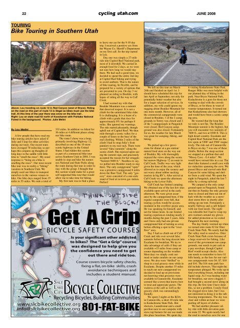
22 cycling utah.com JUNE <strong>2008</strong>TouringBike Touring in Southern <strong>Utah</strong>Above: Lou traveling on route 12 in Red Canyon (west of Bryce). Ridingon the road on this part of route 12 is illegal as bikes must use the biketrail. At this time of the year there was snow on the bike trail .Right: Lou on state road 62 north of Koosharem with Fishlake NationalForest in the background. Photos: Julie MeliniBy Lou MeliniA few people that have read mybike touring articles have asked ifJulie and I stop for other activitiesduring our tours. Our recent tourshave averaged 70 miles/day so perhapsthis conjures up thoughts oflong days in the saddle with littletime to “smell the roses”. My usualresponse is “being on a bike issmelling the roses”. Our most recentbike tour was in reality a “hiking”vacation in Southern <strong>Utah</strong>. Wesimply used our bikes to transportourselves to the various venues tohike. Our bike days ranged from 19miles to 55 miles. We rode a total of333 miles. In addition we hiked for36 miles at 4 different places alongour bike route.The route I chose was a loop,primarily involving Highway 12,described as one of the 10 mostscenic highways in the UnitedStates. I had ridden this sectionas part of a commercial bike touracross Southern <strong>Utah</strong> in 2004. I wasunable to stop and hike the numerousNational and State Parks alongthe route during that tour in order tostay with the group. I thought thatthis section would make for a greatself-supported bike tour that wouldallow me to take time for hiking.My first task was to find a placeto leave our car for the 9-10 daytrip. I received a positive yes fromthe Wayne Co. Sheriff’s Departmenton my first call. So the trip startedin Loa.Day one was simply a 27-mileride into Capitol Reef National park,most of it downhill. We carried inenough food for 2 days, as we werenot sure how long we would staythere. We had such a good time, wedecided to spend the entire 2nd dayat Capitol Reef hiking and tryingto avoid sunburn. That is the natureof bike touring, be flexible, and beprepared for a variety of options thatare presented to you. On day 3 weplanned on riding to Boulder, withhopes of riding all the way to CalfCreek.I had warned my wife thatBoulder Mountain was a summitthat deserved respect. It is not aclimb for the uninitiated bike rider.It is challenging. It is a beast of aclimb with a grade that rises forapproximately 8% for perhaps 8miles. She ignored my warnings.The ride started pleasantly, thoughuphill out of Capitol Reef. We thenrode through a scenic valley for acouple of hours to the base of thereal climbing. Within 2 miles of theclimb I had to strap Julie’s frontpanniers to my rear rack. There wereseveral “false summits” along thescenic climb. She rejoiced upon seeingthe summit sign, and graciouslyaccepted the reason for her struggle:“Summit 9400 ft.”. Needless to say,we pulled into Boulder ready to staythere. The only campground “open”was a primitive campground 6 milesdown the Burr Trail. The only “grocery”store consisted of a one-aislestand of food at in-town gas station.Perfect!We left on this tour on March24th and finished on April 1st. Ishould have scheduled this trip forlate April or September, not only forpotentially better weather but alsofor a larger selection of services. Inaddition, my wife could ignore mynagging about Boulder Mountain forone more month. However, all ofthe commercial campgrounds wereclosed in Boulder, 1 of the 2 campgroundsin Torrey was closed and 2of the 3 campgrounds in Panguitchwere closed. Red Canyon campgroundwas also closed. Fortunatelyfor us, the weather for late Marchwas great for camping, biking, andhiking.We picked up a few provisionsfor dinner at a gas station/natural food store on the way outof Boulder. My wife thoroughlyenjoyed the views along the scenicbut narrow Highway 12 en route toCalf Creek. Traffic was very lightgiven the time of the year, whichallowed us to enjoy the scenery andnot worry about rubber neckingtourists in big RV’s. After arrival atCalf Creek we spent the afternoonhiking to the Lower Falls.Calf Creek has limited camping.We obtained one of the last few sitesavailable upon arrival in the earlyafternoon. We were given assuranceby the campground host, if theregular campsites were full, thattouring cyclists would be accommodatedin the overflow picnic area.He was speaking for himself, andnot for future hosts. In our limitedtouring experiences totaling nearly 2months during the past 3 years, Julieand I have only had one privatecampground hint of turning us awaybefore offering a spot in the “overflow”area.Day 5 had us climb out of CalfCreek and ride over several falsesummits before the long descent intoEscalante for breakfast. We try totake advantage of cafés if they areavailable ≈15 miles from camp orsooner depending on the weather.Most days we simply cook oatmealor make omelets on our campstove. We also were “thrilled” toshop in a real grocery store while inEscalante. Despite another 35 milesto reach our next campground wedecided to load up on provisionsnot knowing what groceries wereavailable in Cannonville. Escalanteseemed like a town that knows howto treat and appreciate guests. Thewaitress at the café as well as thegrocery clerk was outstandinglyfriendly.We spent 2 nights at the KOAin Cannonville, a short 10-mile rideto Kodachrome State Park. Hotshowers, Laundromat and a smallpavilion next to our campsite withstove top burners for our use madethis place luxurious. We spent day6 visiting Kodachrome State Park.Ranger Mike was most helpful withour planned day of hiking in thepark. Near Bryce National Park,Kodachrome is a gem for those notwanting to deal with the crowdsof Bryce, or for those in want ofwarmer temperatures. It turned outthat Kodachrome also had showersand would have been a scenic campingarea.Be warned that the loop thatwe rode is not flat. The BoulderMountain summit is the highest, butyou will encounter two summits of7600 ft., and two at 8300 ft. This ishigh desert country. Escalante andCapitol Reef National Park are thelow spots at 5300’ and 5500’ respectively.The ride out of Cannonvilleto Bryce on day 7 was one of theseclimbs. Before the steep sectionwe stopped at a pullout that said“Mossy Cave - 0.4 miles”. Wewould have missed this in a car. Theshort hike featured a small cave withice stalactites spanning the cave. Wepassed Bryce and moved onto RedCanyon for some hiking and shelterfrom a cold wind. We spent thenight in Panquitch, aided the last 7miles by a strong tailwind.We camped at the only campgroundopen in Panguitch, foundout that on Sunday the only grocerystore is closed and then ran out ofluck with the weather as a snow/sleet storm blew in shortly aftersetting up our tent. Fortunately anearby Subway and a café helpedwith our food needs. The nightwas tolerable but I had to wrap myarm warmers around my glovesfor added protection as we exitedPanquitch the next morning.The day finally warmed up whenwe turned onto route 62 for OtterCreek State Park. We nearly had theflat valley road to ourselves. OtterCreek State Park exists because ofa large reservoir for fishing. Likemost of the government run campgrounds,one needs to put cash ina pay envelope, though CapitolReef would accept checks. Alsoone needs to remember to have $1bills handy, as the fees for our variouscampgrounds were $4, $7, $10and $16. The $16 state park feesdid include showers. That night thetemperature plunged. We woke up tofind everything frozen, including ourliquid soap. As I was heating waterfor breakfast, our stove clogged. Ihad brought a second stove along onthis trip, the first time I have donethis, so not a problem. I easily fixedthe clogged stove later, but I wasnot interested in doing it in the subfreezingtemperatures. The sky wasclear and within an hour we werepeeling off layers of clothes.We had another pleasant valleyride with little elevation gainon route 22. We again nearly hadthe road to ourselves save for one
JUNE <strong>2008</strong> cycling utah.com 23truck that just had to lean on thehorn as if we didn’t see it. Trafficwas otherwise surprisingly pleasantand friendly. Our flat ride endedin Koosharem with a climb out ofthe valley eventually reaching the8300-foot summit before the downhillride back to Loa.This is a trip I hope to repeatagain, though perhaps late in Aprilor mid-September. I want to thankSheriff Kurt Taylor and DeputyCathy Grundy for allowing me toleave my car at the Wayne Countycourthouse. I hope my donation tothe Wayne County Sheriff’s “shopwith a cop” will help show myappreciation. Also it doesn’t hurt fortraveling bicyclists to spread a littlefriendship to those who we hopefullynever have to need.More photos can be seen here:http://gallery.mac.com/melini#100032Tour de Donut to raise money for <strong>Utah</strong> AmberAlert IDThe Rotary Club of American Fork is proud to sponsor the inaugural<strong>Utah</strong> Tour de Donut. Spoofing the concurrently running Tour de France,the Tour de Donut is a 21-mile circuit style race composed of 3 laps, witha little twist. At the completion of each lap, a rider may eat donuts andsubtract 3 minutes from their overall time for each donut eaten.There is a 7-mile exhibition lap available for kids or those who don’twant to ride the full race. The tour will be staged from GreenwoodElementary in American Fork, <strong>Utah</strong>. A t-shirt, donuts and drinks will beprovided for all participants. There will be prizes for category winnersand drawings for great prizes provided by tour sponsors. For more information,visit www.utahtourdedonut.com. Proceeds from the event go tofund the <strong>Utah</strong> Amber Alert ID project to help identify missing children.ROAD RACINGSohm, Kotval Take Bear Lake ClassicRoad RaceBy Ryan Barrett and KarenAppleby-KriegSaturday May, 17 was the BearLake Classic way up north on the<strong>Utah</strong>/Idaho border. The Pro 1/2Men contested two laps around thelake for a total of 104 miles. Raceconditions were ideal with warmweather and a light breeze. The racestarted off relatively tame for thefirst few miles, but things quicklybecame more aggressive with aflurry of attacks towards the northend of the lake eventually resultingin Tommy Nelson (American RADDP/B Agel) off the front alone fornearly 20 miles.Once he was reabsorbed, anothergroup of around 7 riders sprung outof the peloton, and were off the frontfor a similar distance. However,noting that both Park City Jeep<strong>Cycling</strong> and Porcupine/Specializedhad better numbers in the break,American RADD P/B Agel put theremainder of their team on the frontand chased the move down.On the north side of the lake onthe second lap, the group was allback together and the attacks camein rapid succession. Many groupsappeared to be “the break” only tobe brought back into the fold byteams left outnumbered by the currentsplit. Ultimately, a group got agap and was off. Making the splitwere Marc Yap and Ben D’Hulst(Park City Jeep-Goble Knee Clinic),Luis Zamudio and Gardie Jackson(American RADD P/B Agel), MikeSohm (Porcupine/Specialized), ToddHageman (Bingham’s/Northshore),and Mark Skarpohl (CanyonBicycles).With all of the major teams represented,the field shut down and thebreak quickly gained time. Cominginto the finish there were severalstrong attacks, but the break neversplit. Ultimately, it was Sohm winningthe sprint in front of Zamudioand Hageman.In the women’s 1-3 race, 12 of<strong>Utah</strong> and Idaho's finest female racersgathered at the start line of theannual Bear Lake Classic Road Racefor one 52-mile lap around the lake.With 4 teams represented, it wassure to be an aggressive and excitingrace. The race began with an attackby PCIM racer Melissa McDanielwhich was quickly bridged upto by Bountiful Mazda's KellyCrawford. While the two remainedon the attack for several miles, theywere reeled in by the women ofIntermountain Financial/JR SmithCoaching. Quickly after the fieldrejoined, PCIM's Kirsten Kotvalattacked and Bountiful Mazda'sKaren Appleby-Krieg bridged.The two worked together for a fewminutes until they were joined byIntermountain Financial/JR SmithCoaching's Lisa Palmer-Leger. Thethree established a sizable gap onthe field. After 10 minutes of jointwork, Kotval attacked once moreand Appleby-Krieg bridged. The twoworked well together for the next 40miles to maintain their lead all theway to the finish line with Kotvaltaking the sprint, Appleby-Krieghanging on for second, and PCIM'sMelissa McDaniel winning the fieldsprint and coming in third overall.Sunday was a demanding threeman (or woman!) team time trialaround the lake. American RADDP/B Agel stormed to victory with analmost two minute margin on ParkCity Jeep <strong>Cycling</strong> in the men’s Pro1/2 category. Park City Jeep provedtheir depth, however, by having twoteams finish within three seconds ofeach other for second and third onthe day. In the women’s open event,the Bountiful Mazda team took acommanding win.See results on page 20.touring<strong>Cycling</strong> in ‘The Other’ Southern <strong>Utah</strong>By Tina and Scott AndersenEver think of road cycling thesummer in Southern <strong>Utah</strong>? Moaband St. George areas probablycome to mind with their busyroads, and high summer temperatures.Well, maybe you shouldthink again. South Central <strong>Utah</strong> isan oasis that averages in the high70’s to mid 80’s for high temp’sin July and might get up into the90’s for only a week in August.The traffic is low and the roads arenice, in fact you might just be ableto ride miles without encounteringany traffic at all. Elevationscan start at 5,000 feet and climbup to 10,000 feet, perfect trainingfor your long mountain racein the fall. The Loa/Torrey valleysits at approximately 7000 feet.It has great mountain climbs withfrequent wildlife sightings, andeven cooler temperatures. Thereare also long fast flats with a nicetailwind or challenge yourself withsome tough training and take ona headwind. Where is this greatundiscovered location? WayneCounty, <strong>Utah</strong> … ‘ground-zero’!Where is Wayne County?Wayne is located on SR-24 in theheart of South Central <strong>Utah</strong>. Itis about 30 miles southeast ofRichfield. Wayne County featuresthe communities of Loa,Fremont, Lyman, Bicknell, Torrey,Teasdale, Grover, Caineville, andHanksville. The small-town feelof these communities provide for acomfortable low-cost escape fromthe traffic and weather of Northern<strong>Utah</strong> and the rest of Southern<strong>Utah</strong>. There is not a single trafficlight in the entire county. This areais still yet an undiscovered gem.One of <strong>Utah</strong>’s best kept cyclingsecrets. And, it’s just a 2 ½ hourdrive from Provo.The area has several wonderfulhotels, bed and breakfasts, diners,cafes, and amazing restaurants.The hotels range from quaint toextravagant. Your eating optionswill range from local Mexicanfare, and pizza joints, to one of<strong>Utah</strong>’s ‘5-star’ restaurants, TheCafé Diablo. Take your club, team,or fellow bikers to stay the nightand relax, then in the morning takeoff for a tough ride up BoulderMountain, on <strong>Utah</strong> route 12, tothe town of Boulder. Eat a greatlunch perhaps at Hell’s Backbonecafé, another great dining secretrecommended by Oprah, then headback down Boulder Mountain fora relaxing break with friends andfamily.Try an easy ride and enjoythe quiet beauty of Capitol ReefNational Park. The park visitor’scenter provides a wonderful stagingarea for several choice rides.From easy going to very strenuous.A sustained climb up to theTorrey junction for a late breakfastor lunch might be a great way toburn off some calories, or just getwarmed up. Or ride the width ofthis national park taking in theamazing geological formations,water falls, and even some ancientNative American Indian petroglyphs.Another option is to ride upthe ‘back door’ to Fish Lake usingRoute 25 passed Mill Meadowreservoir. This is a very longsustained climb on another sceniclightly traveled road to theFish Lake basin. Stop off at ‘thelodge’ to refill your water bottleshave a snack or some lunch, thencontinue north on SR-25 to theShare The Road License PlateFundraiser<strong>Utah</strong>SHARE THE ROADSR-24 junction. Take Route 24,giving you some rolling hills andfalse flats for your descent backto your base-camp. You mightwant to consider returning to theheadwaters of the Fremont River alittle later in the evening for somechoice fly-fishing. The rivers,lakes, and reservoirs of this regionare kept well stocked with assortedchoice trout.Ride up through Fremont onSR-72 to the summit known tothe locals as ‘Hogan’s Pass’, andview the amazing vista whichoverlooks Factory Butte, the LaSal and Henry Mountains, andthe San Rafael Swell. Make sureone of your cycling buddies has acamera in their jersey for the manyphoto-ops on scenic SR-72. If theweather is cooler, drive or stay inHanksville and ride SR-95 to LakePowell and back.The possibilities are endless.And, it all depends on how youfeel…do you feel tough or do youfeel strong? There will always besome wind, and there can alwaysbe some good sustained climbing.You will leave the county are-energized, stronger, and moremotivated cyclist. Make surecycling in South Central <strong>Utah</strong>makes it on your bucket list!Editor's Note: The CapitolReef Classic on July 18-19 is anew race that showcases ridingin Wayne County for licensedand citizen riders. Find outmore at capitolreefclassic.com.Help create a Share The Road decal and slogan on <strong>Utah</strong>License Plates. Goal: 2500 plates. Unmet Need: $18,000.Send contributions to: <strong>Utah</strong> Bicycle CoalitionPO Box: 581531Salt Lake City, <strong>Utah</strong> 885158-1521Make Checks Payable to: <strong>Utah</strong> Bicycle Coalition7<strong>Utah</strong>123456708Plates will be available to <strong>Utah</strong> vehicle owners on a first comefirst serve basis for additional annual fee of $25/plate/yearFor more information: www.utahbikes.org or KJLiveToBike@gmail.com