F !+ !+ !+ !+ !+!+ !+ !+ - Moray Firth Partnership
F !+ !+ !+ !+ !+!+ !+ !+ - Moray Firth Partnership
F !+ !+ !+ !+ !+!+ !+ !+ - Moray Firth Partnership
- No tags were found...

Create successful ePaper yourself
Turn your PDF publications into a flip-book with our unique Google optimized e-Paper software.
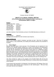
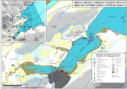
<strong>Moray</strong> <strong>Firth</strong> cSAC: overall area and boundaries of detailed maps''''''TainBalintoreBrora'''20m'HelmsdaleDESIGNATED AREAgdgdgd'$MORAY FIRTH CANDIDATE MARINE SPECIALAREA OF CONSERVATION: CONTEXT (MAP 1)' gd187Jemimaville<strong>Moray</strong> <strong>Firth</strong>NN20m''Beauly''' 'DingwallMuir of Ord''''%UAvoch'gdgdgd'Muir of OrdInvergordon'''Invernessgdgdgd'' ''CromartygdgdMap 1Map 2 (overleaf)'gd gdgdgdBeauly <strong>Firth</strong>'!+ !+Kirkhill 'gd170$Craig PhadrigThis map was developed by the Highland Council with the collaboration of the cSAC management group relevant authoritiesNairn0 1 2 3 4 5 Kilometres'Ü'RAF Kinloss'Lossiemouth'281$Mount Eagle$256Munlochy' gdNorth Kessock!+'N!+ÌÌgdgd191$gdgdgdgdgdð'Inverness!+gdAvoch'!+"Fgd'$192 Rosemarkie$Fortrose '!+Inverness <strong>Firth</strong>Pilot PassageAlturlie Point% Longman landfill site153'Chanonry Pointgdgdgdgd%UÌNgd'Ëð"FFort Georgegd!+'eArdersierDalcross AirportAppendix K - Key features relevant to the<strong>Moray</strong><strong>Firth</strong> cSAC Management SchemecSAC boundarySaddle HillN$376ËCandidate Special Area of ConservationMarine area outwith cSACIntertidal areaDolphin tour boat route (DSP)Best dolphin watching sites onshoreConsented discharge - inspected by SEPASeptic tankDredge siteDisposal site for dredge materialWaste water treatment plantDistilleryRig fabrication / repair yardOil terminalIndustrial estateAquaculture lease areaNB: Commercial fishing activity occurs extensively in the firth.This map is for guidance only and should not be used for navigational purposes.Reproduced from the Ordnance Survey mapping with the permission of the controller of Her Majesty'sStationery Office © Crown Copyright. Unauthorised reproduction infringes CrownCopyright and may lead to prosecution or civil proceedings. The Highland Council LA09036LgdPilot passage for shippingSubsea oil pipeline!+ Slipway/pier/jettyPrincipal diving sitese AirfieldPrime agricultural landRelief< 100m100 - 300m300 - 600m> 600mReliefDepth offshore20m depth contourN
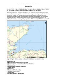
MORAY FIRTH CANDIDATE MARINE SPECIAL AREA 'DornochgdOF CONSERVATION: CONTEXT (MAP 2)gdÌTarbat NessgdNDornoch <strong>Firth</strong>gdRAF Bombing Rangegdgd 'Portmahomack'gdgdTaingdgdgdLoch Eye'gdgdgdgdgd!+ gdKinrive Hill$322Ìgd'gdInvergordon!+ðgdgd!+0 1 2 3 4 5 KilometresgdCromarty <strong>Firth</strong>gdgdgdKildary'"FNigg BayËgd gdgdÌgdNigg!+Ferry Routegd gdgd' gdgd'CromartyNNorth Sutor''"F$Sutors Stacks201Balintoregd'gdgdgdgdgd%UÌNËð"F20mSubsea oil pipeline from Beatrice fieldAppendix K - Key features relevant to the<strong>Moray</strong><strong>Firth</strong> cSAC Management SchemecSAC boundaryCandidate Special Area of ConservationMarine area outwith cSACIntertidal areaDolphin tour boat route (DSP)Best dolphin watching sites onshoreConsented discharge - inspected by SEPASeptic tankDredge siteDisposal site for dredge materialWaste water treatment plantDistilleryRig fabrication / repair yardOil terminalIndustrial estate"Fixed engine" (bag net) salmon fisheriesAquaculture lease areaPilot passage for shippingSubsea oil pipelineRAF bombing range!+ Slipway/pier/jettyPrincipal diving sitese AirfieldPrime agricultural landRelief< 100m100 - 300m300 - 600m> 600mReliefDepth offshore20m depth contourNNB: Commercial fishing activity occurs extensively in the firth.This map is for guidance only and should not be used for navigational purposes.Reproduced from the Ordnance Survey mapping with the permission of the controller of Her Majesty'sStationery Office © Crown Copyright. Unauthorised reproduction infringes CrownCopyright and may lead to prosecution or civil proceedings. The Highland Council LA09036L