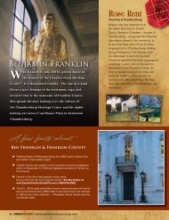
The Battle of Monterey Pass - Explore Franklin County | PA
The Battle of Monterey Pass - Explore Franklin County | PA
The Battle of Monterey Pass - Explore Franklin County | PA

Create successful ePaper yourself
Turn your PDF publications into a flip-book with our unique Google optimized e-Paper software.
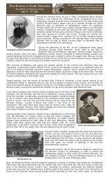
<strong>The</strong> <strong>Battle</strong> <strong>of</strong> <strong>Monterey</strong> <strong>Pass</strong>Driving Tour<strong>Monterey</strong> <strong>Pass</strong> <strong>Battle</strong>field Associationwww.emmitsburg.net/montereypass<strong>The</strong> <strong>Battle</strong> <strong>of</strong> <strong>Monterey</strong> <strong>Pass</strong> tour is roughly 22 miles and takes approximately an hour to do. <strong>The</strong> tour covers some <strong>of</strong> the mostrugged mountain roads in the <strong>Monterey</strong> area. Please use caution when traveling these roads.Stop 1, Fairfield:At Fairfield, General Ewell's wagon train was roughly 17 miles long with the contents <strong>of</strong> "plunder" gathered during the PennsylvaniaCampaign, as a result <strong>of</strong> Confederate foraging from the farms <strong>of</strong> Pennsylvania. Through the driving rain, General Ewell’s wagon trainrumbled out <strong>of</strong> Fairfield, traveling toward Jack’s Mountain. <strong>The</strong> head <strong>of</strong> the wagon column reached Rouzerville late in the evening <strong>of</strong>Saturday July 4th, where the Confederates took the Old Hagerstown Road going along South Mountain toward Smithsburg.From Fairfield, take Iron Springs Road and travel three miles to Gum Springs Road. Turn right onto Gum Springs Road. Gum SpringsRoad cuts between Pine Mountain and Kepner Knob and travels along Toms Creek. This is the road the Confederate wagon train wastraveling on as it approached Fairfield <strong>Pass</strong> about two miles away.Stop 2, Fairfield <strong>Pass</strong>:<strong>The</strong>re is no pull <strong>of</strong>f spot for Fairfield <strong>Pass</strong>. Fairfield <strong>Pass</strong> was the scene <strong>of</strong> the cavalryfight between Colonel Stagg's portion <strong>of</strong> the 1st Michigan Cavalry, who attempted toattack the Confederate wagon train coming from Fairfield. This was the second prongedattack that was ordered by General Kilpatrick as he was attacking <strong>Monterey</strong> <strong>Pass</strong>. <strong>The</strong>original road can be seen today, but is on private property. Once you cross into <strong>Franklin</strong><strong>County</strong> proceed to the top <strong>of</strong> the hill where the road levels out and turns toward the left.Gum Springs Road becomes Furnace Road once you've crossed into <strong>Franklin</strong> <strong>County</strong>.Stay on Furnace Road another two miles until you see an intersection by the railroadtracks. This is old Waynesboro Road. Charmian Lane is directly in front <strong>of</strong> you. Turn leftand proceed one mile to the Fountain Dale Fire Department located on your right at thebottom <strong>of</strong> the mountain. Park at the Fountain Dale Fire Department.Stop 3, Fountain Dale Fire Department: Two interpretive panels are located on the site.Located in the Fountain Dale Fire Department’s parking lot you will see the Fountain Dale skirmish marker and a <strong>Monterey</strong> <strong>Pass</strong><strong>Battle</strong>field marker. This is not the site <strong>of</strong> the June 28, 1863 skirmish, but it is the site <strong>of</strong> where General Kilpatrick ran into a few <strong>of</strong>Captain Emack’s pickets. <strong>The</strong>y were quickly overran and retired up the mountain to <strong>Monterey</strong>. As you travel up the mountain on OldWaynesboro Road, General Kilpatrick describes the road conditions his cavalry experienced. On his right was <strong>Monterey</strong> Peak whichwas a rough, rugged portion <strong>of</strong> <strong>Monterey</strong> <strong>Pass</strong>. To the left was a steep ravine and to his front was a road so narrow that he couldn’teven deploy his artillery.From the Fountain Dale Fire Department make a left and travel up the mountain in the direction you just came. As you re-cross therailroad tracks, this is where the battle <strong>of</strong> <strong>Monterey</strong> began. As you cross the railroad tracks, you'll notice a curve in the road in front<strong>of</strong> you to the left. This is where the Clermont House once stood behind the pine trees. Once the road straightens and begins to levelout, this is where is the first portion <strong>of</strong> the battle <strong>of</strong> <strong>Monterey</strong> began. Pull into the parking lot <strong>of</strong> the Hawley Memorial Church andwalk toward the main road. Walking due east down the road you’ll see a monument for David Miller.Stop 4, <strong>The</strong> David Miller Monument:David Miller was the formal manager <strong>of</strong> the <strong>Monterey</strong> House. At the onset <strong>of</strong> the Civil War he was in theprocess <strong>of</strong> building the Clermont House. As he was taken prisoner, he was held at the <strong>Monterey</strong> House.His expertise helped to guide General Kilpatrick’s cavalry during the confusing fight at <strong>Monterey</strong> <strong>Pass</strong>. Thisis also the area where the Clermont House once stood. <strong>The</strong> monument stands near the hedge row on yourright as you walk down the road a short distance from Hawley Memorial Church. As you walk down to seethe monument look back up the hill from where you were to see where Captain Tanner deployed onecannon.After viewing the monument walk back up the hill to Hawley Memorial Church.Stop 5, Hawley Memorial Church: One interpretive panel is located on the siteTwo interpretive panels are located on the site that explains the Confederate artillery position as well as the opening phase <strong>of</strong> thebattle <strong>of</strong> <strong>Monterey</strong> <strong>Pass</strong>. It is at this location that Captain Tanner’s artillery piece fired into the 5th Michigan. <strong>The</strong> shots were fired toohigh to cause much harm, but it caused much confusion in the ranks <strong>of</strong> the 5th Michigan. Kilpatrick ordered the 8th Pennsylvania todismount and attack Emack via the Clermont House. Captain Emack had pulled his men back to the <strong>Monterey</strong> House forcing Tannerto leave his limber behind where it was captured. Emack was then forced to withdraw from the <strong>Monterey</strong> House back toward<strong>Monterey</strong> <strong>Pass</strong>.Once you read the interpreter markers walk westward to the intersection <strong>of</strong> <strong>Monterey</strong> Lane.Stop 6, <strong>The</strong> Corner <strong>of</strong> <strong>Monterey</strong> Lane:<strong>The</strong> series <strong>of</strong> pine trees to your left <strong>of</strong> <strong>Monterey</strong> Lane is where the <strong>Monterey</strong> Innonce stood. General Kilpatrick stopped at the <strong>Monterey</strong> House where David Millerand Jacob Baer were being held prisoner. Mr. Miller and General Kilpatrick discussedthe roads <strong>of</strong> the area and where they led. Mr. Miller informed General Kilpatrick <strong>of</strong>Mount Zion Road through Raven Rock that led into Smithsburg and Leitersburg.General Kilpatrick sent the 1st Vermont Cavalry down <strong>Monterey</strong> Lane taking Mr.Buhrman as their guide to Smithsburg. General Kilpatrick also ordered Colonel Townto take a regiment to head <strong>of</strong>f the wagon train east <strong>of</strong> <strong>Monterey</strong>. A portion <strong>of</strong> the1st Michigan Cavalry under Lt. Colonel Peter Stagg was sent upon modern dayFurnace Road that led to Fairfield Gap in order to try to head <strong>of</strong>f the Confederatewagon train traveling toward <strong>Monterey</strong> <strong>Pass</strong>, one mile away. This area is whereGeneral Kilpatrick ordered Pennington’s Battery to deploy in order to supportGeneral Custer’s battle line that had stalled near the area <strong>of</strong> the Rolando WoodsLions Club Park. General Kilpatrick also sent the 1st West Virginia Cavalry to support General Custer.From Hawley Memorial Church, continue on Old Waynesboro Road, passing the <strong>Monterey</strong> <strong>County</strong> Golf Course, for about a half <strong>of</strong>mile. You will see Rolando Woods Memorial Park that will be on your right. Route 16 is directly in front <strong>of</strong> you. Park at RolandoWoods.
Stop 7, Rolando Woods Lion’s Club Park: Two interpretive panels are located on the site.Rolando Woods Lions Club Park is where General Custer attacked Captain Emack at the pass and could see the wagon train towardhis right as it came upon the Emmitsburg and Waynesboro Pike. <strong>The</strong> old tollhouse is located across modern day Route 16. This iswhere the old Furnace Road, Mentzer Gap Road and Pennersville Road intersected with the old Emmitsburg and Waynesboro Pike.This section is where General Custer’s men over ran Emack who was reinforced by the 6th Virginia and the 4th North CarolinaCavalry. Crossing Red Run Creek, Custer sent the 1st West Virginia Cavalry charging through and they started destroying wagonsand taking on prisoners. Kilpatrick kept this up until he was at the base <strong>of</strong> the mountain in Waterloo, known as Rouzerville today. Asyou travel down the mountain, you’ll notice on your right, that the mountain starts to descend. This is the area that is <strong>of</strong>tendescribed as where the wagons were forced <strong>of</strong>f <strong>of</strong> the cliffs trying to out run General Kilpatrick’s cavalry.Use caution and cross over Route 16 (Buchanan Trail) and continue on Old Waynesboro Road to Rouzerville. Once you are nearingRouzerville, you will see a yellow caution road sign for a 20 mile per hour sharp right-hand turn with a road directly to your front.This is Waterloo Road. Take Waterloo Road to PenMar Road. Notice Harbaugh Church Road is directly in front <strong>of</strong> you. Make a left onPenMar Road and travel up the mountain. Once you are at the top <strong>of</strong> the mountain, make a right onto High Rock Road and travel toPenMar Park. Park at PenMar Park.Stop 8, PenMar Park: One Maryland Civil War Trails interpretive wayside exhibit is located on the site.From Rolando Woods Lions Club Park to PenMar Park is approximately four miles. PenMar Park sits at an altitude <strong>of</strong> 1,400 feet, and<strong>of</strong>fers one <strong>of</strong> the finest scenic views in Maryland with a clear view <strong>of</strong> the Cumberland Valley. Bathrooms are located on the premisesand are open during park hours.From PenMar Park continue up the mountain on High Rock Road for about two miles to High Rock. Parking is located on your right.Warning, use caution as this is not handicap accessible nor are there any guard rails. Please caution children when on High Rock. Ifyou’re afraid <strong>of</strong> heights, proceed to stop 10.Stop 9, High Rock:Standing on the highest point <strong>of</strong> South Mountain in Maryland, High Rock <strong>of</strong>fers a fineview <strong>of</strong> the Cumberland Valley. This area was used by Union troops serving in the SignalCorps in 1864 as they witnessed the burning <strong>of</strong> Chambersburg. At High Rock you cansee Smithsburg to your extreme left and Ringgold in the center and Waynesboro to yourright.Retrace your route back to PenMar Park to PenMar Road. Make a left turn on PenMarRoad continue down the mountain until you reach Harbaugh Church Road. Make a lefton Harbaugh Church Road and continue to Midvale Road. Make a left onto Midvale Road.At the Maryland Border Midvale Road becomes Md. State Route 418. Turn right on toMisty Meadow Road. You'll see a red brick building ahead near a cemetery to your left.This brick building is called the Ringgold Meeting House and was not here during thetime <strong>of</strong> the Civil War.Stop 10, Ringgold, Maryland:General Kilpatrick traveled to Ringgold, where he ordered his division to halt after the battle <strong>of</strong> <strong>Monterey</strong> <strong>Pass</strong> and the affair atWaterloo. <strong>The</strong> casualties <strong>of</strong> these battles proved to be devastating for the Confederates. General Kilpatrick stated his losses at<strong>Monterey</strong> <strong>Pass</strong> were 6 killed, 12 wounded, and 30 captured. <strong>The</strong> Confederate Official Reports state that the Confederates lost morethan one thousand men captured at the battle <strong>of</strong> <strong>Monterey</strong> <strong>Pass</strong> and along the Waynesboro and Emmitsburg Road. Kilpatrick fromthis point will order his cavalry to Smithsburg which is only a few miles away.<strong>The</strong> tour ends here. Travel back to MD Route 418. You can make a left and follow it to a stop light which is <strong>PA</strong> Route 16 or if youmake a right from 418 and follow it to the flashing four way stop, this is the Smithsburg Road. You can go to Smithsburg &Hagerstown (left), Leitersburg (straight) or Waynesboro (right) from this point.