JeppView : FIMP (7 charts) - With Malice
JeppView : FIMP (7 charts) - With Malice
JeppView : FIMP (7 charts) - With Malice

Create successful ePaper yourself
Turn your PDF publications into a flip-book with our unique Google optimized e-Paper software.
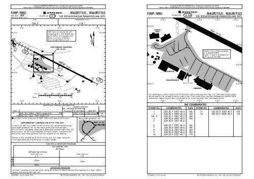
BRIEFING STRIP TM5 05 104000316^FI(D)-029.0to BIGARA136^4000NoPT4000 NoPTIPLD12.4 PLS181^2360'001^181^239^15.0FI(R)-15334^1587'136^4000'(3817')BIGARA/MKRD10.0 IPLD9.4 PLS2.0FI(D)-011763'FI(R)-12FI(P)-06FI(R)-13Gnd speed-Kts 70 90 100 120 140 160Descent Gradient 6.5% 461 592 658 790 922 1053MAP at PLS VOR/D0.6 IPLCHANGES: MSA. Procedure bearings.7.34000059^3400'(3217')(IAF)PLAISANCEP L SD0.6 IPLD113.7 PLSMAURITIUS, MAURITIUSVOR DME Rwy 14JEPPESENSIR SEEWOOSAGUR4 JAN 02RAMGOOLAM INTL13-1*ATIS*MAURITIUS Approach*MAURITIUS Approach/Tower126.2119.1 118.1VORFinal Minimum AltMDA(H) Apt Elev 183'PLSApch Crs CUREPIPE860'(677')113.7 136^ 3400' (3217')RWY 183'MISSED APCH: Climb to 4000' on heading 136^ and contact ATC.Alt Set: hPa Rwy Elev: 7 hPa Trans level: By ATC Trans alt: 4000' (3817')(IAF)GRAND BAYDG 114.8 B GBY20-10Y1413'Arrival via GBY VOR2066'from N and NE wheninstructed by ATC.NOT TO SCALEPANS OPS 3D15.0 GBY136^4000D13.0IPL DME reads zeroat rwy 14 threshold.IPL DME/PLS DME 6.0/5.4 4.0/3.4ALTITUDE (HAT)2610' (2427') 1820'(1637')CUREPIPED8.0 IPL D3.0D5.0IPL136^136^PAPI136^HIALS40003800'059^195^3100'2600'285^MSA PLS VORDME ARC PROCEDUREDME Arc procedure applicablefor acft arriving from SW toNE quadrant and only whenFF NDB inoperative.NoPTD2.023 DME Arc PLSIPL20-202550' D12.4 PLS2579'1709'1798' (IAF) 2073'MKR to D13.0 IPL FI(P)-11FLIC EN FLAC(IF)316^ 12.4 4000ILS DMEBIGARAF 258 FF1391' I 109.9 P IPLD10.0 IPLLD19.0 IPL D9.4 PLS CUREPIPE1070'D18.4 PLS D8.0 IPL1211'D7.4 PLS2720'D5.0IPLD4.4 PLSWARNING: PLS VOR indicationsshould be used with integer distancesD3.0IPLfrom IPL DME which is paired withD2.4 PLSILS and gives distances fromrwy 14 threshold. Decimal2309'distances from PLS VORD2.0IPL(0.6 NM from rwy 14 threshold)D1.4 PLSshould only be considered when DME 1 Acft arrivingindicator can display tenth of NM.57-30from E & SE.57-40ABCDD13.0Licensed to BRITISH AIRWAYS PLC, . Printed from <strong>JeppView</strong> disc 23-06.Notice: After 7.12.2006 0901Z this chart should not be used without first checking <strong>JeppView</strong> or NOTAMs.298'/NM (4.9 %)STRAIGHT-IN LANDING RWYMDA(H) 860'(677')RVR 720mVIS 800m2400m2800mD23316^NoPTMHA4000D19.0 PLSto D13.0 IPL6.6 40001575'PLAISANCE343 MS136^hdg40002055'316^4000' 136^onhdg| JEPPESEN SANDERSON, INC., 2001, 2002. ALL RIGHTS RESERVED.1D13.0 IPLPLSVOR DMEM Sto PLS VOR326^ 2.0 4000IPLIPL D1.4 PLSD7.4 PLSD2.4 PLSD4.4 PLSPLS VORD0.6 IPL1030'OCA(H) RWY 14(847')860'(677')(2037') 2220' 1430'3.0 (1247') 2.0 1.0RWY 14183'1.4 0.614ALS out1500m1600m3200mRVRVIS3600m1.0/0.4640'(457')1BRIEFING STRIP TM5 05 10PANS OPS 3<strong>FIMP</strong>SIR SEEWOOSAGURRAMGOOLAM INTL147^327^FI(P)-11153^147^CAT C & DCAT A & BJEPPESEN13-2*MAURITIUS ApproachMAURITIUS, MAURITIUSVOR DME Rwy 32NOT TO SCALE123^D15.0*MAURITIUS Approach/Tower126.2119.1118.1VORFinal Minimum AltMDA(H) Apt Elev 183'PLSApch CrsD6.8Refer to3100'113.7 316^ 1500'(1402') Minimums RWY 98' 3800'MISSED APCH: Turn LEFT as soon as practicable to intercept andfollow R-225 climbing to 4000' and contact ATC.2600'MAX IAS 185 KT before established on R-225.Alt Set: hPa Rwy Elev: 4 hPa Trans level: By ATC Trans alt: 4000' (3902') MSA PLS VOR20-201709' 2055'20-30Gnd speed-KtsDescent GradientMAP at MKR/D3.0ABCD2092'1070'225^Licensed to BRITISH AIRWAYS PLC, . Printed from <strong>JeppView</strong> disc 23-06.Notice: After 7.12.2006 0901Z this chart should not be used without first checking <strong>JeppView</strong> or NOTAMs.4000*ATIS1211'PLS DMEALTITUDE (HAT)OCA(H) RWY 32ABC: 510' (412')D: 570'(472')CHANGES: MSA. Procedure bearings.PLAISANCEP 113.7 L PLSSDPLAISANCE343 M SMS4 JAN 02147^ CAT A & B153^ CAT C & D70 90 100 120 140 1605.2% 369 474 527 632 737 843ALS out316^271^6.41500D20.0123^5000130303^500057-40 57-50 58-004000'(3902')RWY 32VOR1575'MKRD3.0D6.84.0700' (602')98' 0.7STRAIGHT-IN LANDING RWYABC: 510' (412')MDA(H)D: 570'(472')1600m2000m2400m316^D8.0MKRD3.0328.215005.01020' (922')3.8MaxKtsD6.8PAPIALS059^PAPIMDA(H)(687')(737')(1197')195^285^KINIXRefer toMissed ApchaboveCIRCLE-TO-LANDProhibited Northeastof runway100 870'135 920'180 1380'205 1510' (1327')6.01340' (1242')D8.01500'(1402')1600m1600m4800m4800m| JEPPESEN SANDERSON, INC., 1999, 2002. ALL RIGHTS RESERVED.
BRIEFING STRIP TM<strong>FIMP</strong>SIR SEEWOOSAGURRAMGOOLAM INTLNDBMS343Licensed to BRITISH AIRWAYS PLC, . Printed from <strong>JeppView</strong> disc 23-06.Notice: After 7.12.2006 0901Z this chart should not be used without first checking <strong>JeppView</strong> or NOTAMs.126.2FinalApch Crs299^Minimum AltNo FAFJEPPESEN16-1MDA(H)550'(452')MISSED APCH: Turn LEFT as soon as practicable to intercept andfollow 225^ from NDB climbing to 4000' and contact ATC.MAX IAS 185 KT before established on 225^ from NDB.MAURITIUS, MAURITIUSNDB Rwy 32Apt ElevRWY118.1183'98'Alt Set: hPa Rwy Elev: 4 hPa Trans level: By ATC Trans alt: 4000' (3902')1763'*ATIS4 JAN 02*MAURITIUS Approach1650'119.1*MAURITIUS Approach/Tower3800'059^195^3100'2600'285^MSA PLS VOR5 05 1020-202251'20-30FI(P)-06FI(R)-131391'2092'1070'OCA(H) RWY 32550' (452')FI(P)-11PLAISANCEDP 113.7 L PLSS137^4000317^225^PLAISANCE343 M SMS131^137^MKR131^CAT A & BCAT C & DCAT A & BCAT C & D57-40 57-504000'(3902')1709'1211'NDB1575'MKR2055'137^299^Final approach trackoffset 17^ from rwycenterline.1500'(1402')299^Startturn at3 MinPANS OPS 3MAP at NDBABCDRWY 32CHANGES: MSA. Procedure bearings.98'STRAIGHT-IN LANDING RWY0MDA(H) 550'(452')1600m2000m2400m320.7ALS outMaxKts100 870'135 920'180205PAPIALSMDA(H)(687')(737')PAPICIRCLE-TO-LANDProhibited Northeastof runway1380' (1197')1510' (1327')Refer toMissed Apchabove1600m1600m4800m4800m| JEPPESEN SANDERSON, INC., 1999, 2002. ALL RIGHTS RESERVED.