Erosion in the Palouse - Steep III (Solutions To Environmental and ...
Erosion in the Palouse - Steep III (Solutions To Environmental and ...
Erosion in the Palouse - Steep III (Solutions To Environmental and ...

You also want an ePaper? Increase the reach of your titles
YUMPU automatically turns print PDFs into web optimized ePapers that Google loves.
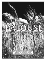
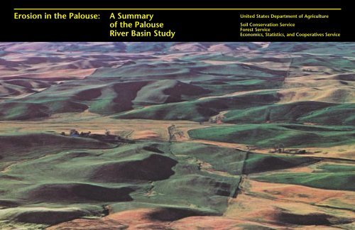
2<strong>Erosion</strong> <strong>in</strong> <strong>the</strong> <strong>Palouse</strong>:A Summary of<strong>the</strong> <strong>Palouse</strong>River Bas<strong>in</strong> StudyUnited States Department of AgricultureSoil Conservation ServiceForest ServiceEconomics, Statistics, <strong>and</strong> Cooperatives ServiceComplex topography<strong>in</strong>creases erosion hazard ondry cropl<strong>and</strong> of <strong>the</strong> bas<strong>in</strong>.WASHINGTON FEBRUARY 1979
Introduction3In January 1976, three agencies of <strong>the</strong>U.S. Department of Agriculture <strong>in</strong>itiateda study of <strong>the</strong> <strong>Palouse</strong> River Bas<strong>in</strong> <strong>in</strong>Wash<strong>in</strong>gton <strong>and</strong> Idaho. The massiveamount of data, observations, projections,<strong>and</strong> conclusions produced by <strong>the</strong> studyhave been consolidated <strong>and</strong> published as<strong>the</strong> <strong>Palouse</strong> River Bas<strong>in</strong> Study Report. Thispublication is a summary of that report.The study was undertaken at <strong>the</strong> requestof Wash<strong>in</strong>gton State Department ofEcology (DOE). Mak<strong>in</strong>g <strong>the</strong> study were<strong>the</strong> Soil Conservation Service, ForestService, <strong>and</strong> Economics, Statistics, <strong>and</strong>Cooperatives Service.DOE requested <strong>the</strong> study to providefactual <strong>in</strong>formation <strong>and</strong> data it needed forwater quality plann<strong>in</strong>g to comply with <strong>the</strong>Federal Water Pollution Control ActAmendments of 1972. The amendmentscall for fishable, dr<strong>in</strong>kable, swimmablewaters <strong>in</strong> our nation’s streams by 1985. Thishas provided new impetus for <strong>the</strong> plann<strong>in</strong>g<strong>and</strong> <strong>in</strong>stallation of conservation practices.The primary use of <strong>the</strong> <strong>Palouse</strong> studydata is gett<strong>in</strong>g conservation on <strong>the</strong> l<strong>and</strong><strong>and</strong> improv<strong>in</strong>g <strong>the</strong> quality of water <strong>in</strong><strong>the</strong> bas<strong>in</strong>:• Local water quality committeesorganized under Section 208 of <strong>the</strong>Clean Water Act of 1977 can use <strong>the</strong>study results as a basis for select<strong>in</strong>gbest management practices <strong>and</strong>develop<strong>in</strong>g water quality plans.• DOE can use <strong>the</strong> study <strong>in</strong> evaluat<strong>in</strong>gthose plans <strong>and</strong> practices.• Individual farmers can relate study<strong>in</strong>formation to <strong>the</strong>ir own farm<strong>in</strong>gconditions <strong>and</strong> cropp<strong>in</strong>g systems.• Conservation districts <strong>and</strong> agenciesassist<strong>in</strong>g farmers can use data <strong>and</strong><strong>in</strong>formation from <strong>the</strong> study to guide<strong>the</strong>ir advice <strong>and</strong> assistance.• The general public can achieve a betterunderst<strong>and</strong><strong>in</strong>g <strong>and</strong> perspective of <strong>the</strong>complex conditions <strong>and</strong> problems—<strong>and</strong><strong>the</strong>refore have a basis for support<strong>in</strong>gattempts to arrive at solutions.Help <strong>in</strong> gett<strong>in</strong>g <strong>the</strong> conservationjob done can be obta<strong>in</strong>ed from severalagencies. Technical assistance is availablefrom local soil <strong>and</strong> water conservationdistricts, <strong>the</strong> Soil Conservation Service, <strong>and</strong><strong>the</strong> Extension Service. F<strong>in</strong>ancial assistancemay be received from AgriculturalStabilization <strong>and</strong> Conservation Service <strong>and</strong><strong>the</strong> Farmers Home Adm<strong>in</strong>istration.For a copy of <strong>the</strong> complete study reportor more <strong>in</strong>formation about it, contact <strong>the</strong>Soil Conservation Service, Room 360, U.S.Courthouse, Spokane, WA 99201.
4The L<strong>and</strong>Called <strong>Palouse</strong>Western portionAnnual precipitation: 12–15"<strong>To</strong>pography <strong>and</strong> soils: gentlyroll<strong>in</strong>g hills, mostly shallowloess soils over basaltPrimary use: rangel<strong>and</strong>Crops: w<strong>in</strong>ter wheat,summerfallowSNAKECentral portionAnnual precipitation: 15–18"<strong>To</strong>pography <strong>and</strong> soils: steepslopes <strong>and</strong> deep loess soilsPrimary use: cropl<strong>and</strong>Crops: wheat, barleyRIVERWASHINGTONEastern portionAnnual precipitation: 18" +<strong>To</strong>pography <strong>and</strong> soils:moderately steep loess hills<strong>in</strong> Wash<strong>in</strong>gton; steepmounta<strong>in</strong> forests <strong>in</strong> IdahoPrimary use: cropl<strong>and</strong>Crops: wheat, barley, fieldpeas, lentilsIDAHONRangel<strong>and</strong>Cropl<strong>and</strong>Forest l<strong>and</strong>An early pioneer, writ<strong>in</strong>g about 1900, saidthis about <strong>the</strong> <strong>Palouse</strong> River:I have followed its cool, w<strong>in</strong>d<strong>in</strong>g currents to<strong>the</strong>ir birthplace <strong>in</strong> <strong>the</strong> mounta<strong>in</strong>s...traveledthrough its shady forests <strong>and</strong> over its grassymeadows...<strong>and</strong> sought its shady banks <strong>in</strong>quest of trout. At that time, its waters werepure...<strong>the</strong> meadows <strong>and</strong> woods wereunmarred by civilization <strong>and</strong> it was a veryparadise for <strong>the</strong> sportsman. S<strong>in</strong>ce <strong>the</strong>n,numerous herds have been driven to itsmeadows to graze. As far up as logs can befloated upon its surface, <strong>the</strong> hillsides havebeen made to contribute <strong>the</strong>ir wealth oftimber—fir, p<strong>in</strong>e, cedar <strong>and</strong> tamarack—tofeed <strong>the</strong> mills on <strong>the</strong> river as far down asColfax. And <strong>the</strong> water has been pollutedfrom its source by <strong>the</strong> search for gold <strong>in</strong> <strong>the</strong>Hoodoo m<strong>in</strong>es.
5The quest for gold cont<strong>in</strong>ued only for arelatively short period. But <strong>the</strong> quest forever-<strong>in</strong>creas<strong>in</strong>g yields of golden wheat goeson—at <strong>the</strong> cost of millions of tons of fertilesoil each year.The <strong>Palouse</strong> River heads <strong>in</strong> <strong>the</strong> ClearwaterMounta<strong>in</strong>s of north-central Idaho. From<strong>the</strong>re it w<strong>in</strong>ds through forested foothills,undulat<strong>in</strong>g cropl<strong>and</strong>, <strong>and</strong> craggy scabl<strong>and</strong>s,plung<strong>in</strong>g over <strong>Palouse</strong> Falls <strong>and</strong> <strong>in</strong>to <strong>the</strong>Snake River.Geological events that occurred millionsof years ago created <strong>the</strong> <strong>Palouse</strong> countrywith its many variations <strong>in</strong> topography:channeled scabl<strong>and</strong>s <strong>and</strong> gently roll<strong>in</strong>gloess hills <strong>in</strong> <strong>the</strong> western part of <strong>the</strong> bas<strong>in</strong>,very steep to roll<strong>in</strong>g hills <strong>in</strong> <strong>the</strong> centralbas<strong>in</strong>, more gently roll<strong>in</strong>g loess hills <strong>in</strong> <strong>the</strong>east, <strong>and</strong> steep forested mounta<strong>in</strong>s <strong>in</strong> <strong>the</strong>upper watershed.The bas<strong>in</strong> dra<strong>in</strong>ed by <strong>the</strong> <strong>Palouse</strong> River<strong>and</strong> its tributaries encompasses more than2 million acres <strong>in</strong> parts of five counties <strong>in</strong>eastern Wash<strong>in</strong>gton <strong>and</strong> two counties <strong>in</strong>nor<strong>the</strong>rn Idaho.The bas<strong>in</strong> is noted for some of <strong>the</strong> highestgra<strong>in</strong> production <strong>in</strong> <strong>the</strong> world. It is also notedfor some of <strong>the</strong> worst erosion <strong>in</strong> <strong>the</strong> country.More than half <strong>the</strong> bas<strong>in</strong> is highlyproductive cropl<strong>and</strong>. Approximately 28percent is rangel<strong>and</strong> <strong>and</strong> 11 percent isforested. A major producer of w<strong>in</strong>terwheat, peas, <strong>and</strong> lentils, <strong>the</strong> <strong>Palouse</strong>supplies more than 10 percent of <strong>the</strong>soft, white w<strong>in</strong>ter wheat grown <strong>in</strong> <strong>the</strong>United States.Annual precipitation ranges from lessthan 12 <strong>in</strong>ches <strong>in</strong> <strong>the</strong> west to more than35 <strong>in</strong>ches <strong>in</strong> <strong>the</strong> east. Most of it occurs <strong>in</strong>w<strong>in</strong>ter <strong>and</strong> spr<strong>in</strong>g.Rapid settlement of <strong>the</strong> <strong>Palouse</strong> did notbeg<strong>in</strong> until <strong>the</strong> 1860’s. Although <strong>the</strong> deepsoils were capable of high yields, <strong>the</strong> marketfor gra<strong>in</strong>s was limited until railroads wereconstructed <strong>in</strong> <strong>the</strong> 1880’s. The railroadsbrought <strong>in</strong> newer, better equipment <strong>and</strong> <strong>the</strong>farmers began work<strong>in</strong>g <strong>and</strong> plant<strong>in</strong>g <strong>the</strong>hillsides. From <strong>the</strong>n on, soil erosion hasbeen a cont<strong>in</strong>uous <strong>and</strong> <strong>in</strong>creas<strong>in</strong>g problem.The com<strong>in</strong>g of <strong>the</strong> tractor broughtfur<strong>the</strong>r changes. <strong>Steep</strong>er slopes could beworked. As tractors replaced horses, <strong>the</strong>extent of soil-protect<strong>in</strong>g crops—pasture<strong>and</strong> hay—dim<strong>in</strong>ished, erosion accelerated.Dur<strong>in</strong>g <strong>the</strong> 1930’s, <strong>the</strong> Soil <strong>Erosion</strong>Experiment Station, soil conservationdistricts, <strong>the</strong> Soil Conservation Service,<strong>and</strong> Civilian Conservation Crops madeheadway <strong>in</strong> gett<strong>in</strong>g l<strong>and</strong>owners to putconservation on <strong>the</strong> l<strong>and</strong>. But World WarII fostered all-out production. And s<strong>in</strong>ce<strong>the</strong>n, economic fluctuations, allotments,<strong>and</strong> o<strong>the</strong>r factors have created o<strong>the</strong>robstacles to soil conservation.
6<strong>Erosion</strong> <strong>in</strong> <strong>the</strong> <strong>Palouse</strong>:How Bad Is It?
7Frozen surface soil<strong>in</strong> early spr<strong>in</strong>g ishighly erosive.S<strong>in</strong>ce 1939, total erosion on <strong>Palouse</strong>cropl<strong>and</strong> has averaged 360 tons peracre—more than 9 tons per acre per year.<strong>Erosion</strong> rates on rangel<strong>and</strong> <strong>and</strong>forested areas average less than 1 tonper acre per year. On cropl<strong>and</strong>, however,annual rates of 20 to 30 tons per acre arecommon <strong>and</strong> losses of 100 to 200 tonsfrequently occur on some steep slopes.<strong>Erosion</strong> has consistently been highest<strong>in</strong> <strong>the</strong> <strong>in</strong>termediate 15-to-18 <strong>in</strong>chprecipitation zone, averag<strong>in</strong>g 20 tonsper acre per year. The rates are usuallyless <strong>in</strong> <strong>the</strong> low-precipitation zone of <strong>the</strong>western bas<strong>in</strong> (13 tons per acre per year)<strong>and</strong> <strong>in</strong> <strong>the</strong> high-precipitation zone of<strong>the</strong> eastern bas<strong>in</strong> (12 tons).Gully erosion accounts for only am<strong>in</strong>or part of soil erosion <strong>in</strong> <strong>the</strong> bas<strong>in</strong>.Stream channel erosion accounts for lessthan 1 percent of total erosion <strong>in</strong> <strong>the</strong>bas<strong>in</strong>, but it is serious <strong>in</strong> <strong>the</strong> mounta<strong>in</strong>forests, where it accounts for 50 percentof <strong>the</strong> total.The high erosion rates on cropl<strong>and</strong>leave <strong>the</strong> l<strong>and</strong> less productive. All <strong>the</strong>orig<strong>in</strong>al topsoil has been lost from 10percent of <strong>the</strong> cropl<strong>and</strong> <strong>in</strong> <strong>the</strong> bas<strong>in</strong>;one-fourth to three-fourths has beenlost from ano<strong>the</strong>r 60 percent.Estimatedaverage annualsediment yield <strong>in</strong>source to streamsystem—<strong>Palouse</strong>River Bas<strong>in</strong>SourceCropl<strong>and</strong>Noncropl<strong>and</strong>*Stream channels<strong>To</strong>talSedimentproduced byerosion—tons17,471,0001,646,00021,00019,138,000Deliveryratio30%11%90%*Includes forest, rangel<strong>and</strong>, roads <strong>and</strong> o<strong>the</strong>r areas.SedimentYield—tons5,167,000184,00019,0005,370,000
8Effects of erosionThe millions of tons of topsoil thaterode from cropl<strong>and</strong> each yearrepresent not only <strong>the</strong> loss of anirreplaceable resource but also amajor source of silt <strong>and</strong> waterpollution. Silt smo<strong>the</strong>rs crops <strong>in</strong>bottoml<strong>and</strong> areas, <strong>and</strong> it fills streamchannels, waterways, <strong>and</strong> dra<strong>in</strong>ageditches, <strong>in</strong>creas<strong>in</strong>g flood problems.In late w<strong>in</strong>ter <strong>and</strong> spr<strong>in</strong>g,<strong>Palouse</strong> Falls is brown withsediment. From <strong>the</strong>re <strong>the</strong>suspended sediment is carrieddownstream, where it fills reservoirsof hydroelectric plants, destroysfish habitat, ru<strong>in</strong>s recreation areas,<strong>and</strong> pollutes o<strong>the</strong>r waters, mak<strong>in</strong>g<strong>the</strong>m unfit for many uses.Annual erosion on cropl<strong>and</strong> <strong>in</strong><strong>the</strong> <strong>Palouse</strong> Bas<strong>in</strong> is now estimatedto be more than 17 million tons.Unless farm<strong>in</strong>g systems change,<strong>the</strong> rates are expected to <strong>in</strong>crease.The <strong>Palouse</strong> study shows, however,that <strong>the</strong> problems of erosion,sedimentation, <strong>and</strong> waterpollution can be greatly reduced.Isl<strong>and</strong>s of silt deposited<strong>in</strong> <strong>the</strong> mouth of <strong>the</strong><strong>Palouse</strong> River.Pioneer relic <strong>and</strong>wheat coveredwith sediment.
9Cropl<strong>and</strong> sedimentfills road ditch.Sediment reducesSnake River Reservoircapacity.
10What CanConservation Do?Fall chisel<strong>in</strong>gpreservessurface residues.
11Some beneficial conservation practicesFarmers can’t change <strong>the</strong> wea<strong>the</strong>r, <strong>the</strong>k<strong>in</strong>d of soil, or <strong>the</strong> slope of <strong>the</strong>ir l<strong>and</strong>, but<strong>the</strong>y can change <strong>the</strong> way <strong>the</strong>y farm <strong>the</strong>l<strong>and</strong>. They can reduce acreages of summerfallow, till <strong>the</strong> soil less, retire steep areasfrom cultivation, change cropp<strong>in</strong>gsystems, divide long slopes with two ormore crops, <strong>and</strong> <strong>in</strong>stall terraces on long,gentle slopes.Summer fallow, especially <strong>in</strong> <strong>the</strong> higherra<strong>in</strong>fall portions of <strong>the</strong> central <strong>and</strong> easternbas<strong>in</strong>, is a major contributor to soilerosion. When fields are summer fallowed,uncropped l<strong>and</strong> is clean tilled dur<strong>in</strong>g<strong>the</strong> summer to control weeds <strong>and</strong> storemoisture for growth of <strong>the</strong> next year’scrop. <strong>Erosion</strong> rates on summer-fallowfields average 25 to 30 percent higherthan those on nonfallow fields.Excessive cultivation also <strong>in</strong>creaseserosion. M<strong>in</strong>imum tillage for seedbedpreparation on annually cropped l<strong>and</strong>or stubble mulch<strong>in</strong>g on summer-fallowfields can reduce erosion rates 35 percent.More than 50 percent of <strong>the</strong> erosion<strong>in</strong> <strong>the</strong> bas<strong>in</strong> comes from <strong>the</strong> steepest 25percent of its cropl<strong>and</strong>. Retirement of thisl<strong>and</strong> from cultivation would significantlyreduce erosion <strong>and</strong> sediment.Fields planted to small gra<strong>in</strong> crops,such as wheat or barley, erode <strong>the</strong> least.Increas<strong>in</strong>g <strong>the</strong> acreage planted to <strong>the</strong>secrops can reduce erosion significantly.Divided-slope farm<strong>in</strong>g <strong>and</strong> fieldstripcropp<strong>in</strong>g can reduce erosion rates 15to 28 percent. Terraces can reduce erosionrates an average of 8 to 13 percent. Onsome long slopes, terraces can reduceerosion rates by as much as 50 percent.Annual cropp<strong>in</strong>greduces soil moistureas well as erosionhazard.
12Stripcropp<strong>in</strong>g dividesa slope to reducerunoff <strong>and</strong> erosion.Level terraces keepwater where it falls.
13Us<strong>in</strong>g appropriatecomb<strong>in</strong>ations of practicesThe <strong>Palouse</strong> study evaluated <strong>the</strong> effectsof apply<strong>in</strong>g comb<strong>in</strong>ations of <strong>the</strong>seconservation practices with differentcropp<strong>in</strong>g systems. It concluded thaterosion rates on nearly level <strong>and</strong> gentlyslop<strong>in</strong>g l<strong>and</strong>s can be reduced to lessthan 5 tons per acre if <strong>the</strong> right comb<strong>in</strong>ationsare used.<strong>Erosion</strong> on steeper slopes can also bereduced significantly, but on <strong>the</strong> steepestslopes it will rema<strong>in</strong> high if cultivation iscont<strong>in</strong>ued. <strong>Erosion</strong> on steep l<strong>and</strong> can bestbe controlled by retir<strong>in</strong>g it from cultivation<strong>and</strong> establish<strong>in</strong>g a permanent plant cover.There is no s<strong>in</strong>gle “best conservationpractice” for all farms. Comb<strong>in</strong>ations ofvarious practices that meet <strong>the</strong> needs of<strong>the</strong> l<strong>and</strong> are <strong>the</strong> most successful. The<strong>Palouse</strong> study can guide (<strong>in</strong>dividual <strong>and</strong>group) efforts to select <strong>the</strong> proper comb<strong>in</strong>ations.Apply<strong>in</strong>g various levels of conservationtreatment to <strong>the</strong> l<strong>and</strong> will affect <strong>the</strong>economy of <strong>the</strong> bas<strong>in</strong>. But erosion ratescan be reduced by 40 percent <strong>in</strong> <strong>the</strong> low<strong>and</strong> high precipitation zones <strong>and</strong> 60percent <strong>in</strong> <strong>the</strong> <strong>in</strong>termediate precipitationzone—without decreas<strong>in</strong>g farm <strong>in</strong>come.The erosion rate can be reduced 80percent through maximum levels ofconservation practices <strong>and</strong> retirementof 35,000 acres of steep, erodible l<strong>and</strong>.Achiev<strong>in</strong>g this level of reduction wouldcost more than $29 million <strong>in</strong> reducedproductivity <strong>and</strong> <strong>in</strong>creased operat<strong>in</strong>gcosts.As erosion rates are reduced throughconservation, less sediment will bedelivered to stream systems. Cropp<strong>in</strong>g<strong>in</strong>stead of summer fallow<strong>in</strong>g <strong>in</strong>creasesfuel <strong>and</strong> fertilizer use but reduces erosion.Reduc<strong>in</strong>g erosion improves water qualitygreatly by reduc<strong>in</strong>g sedimentation.Retir<strong>in</strong>g very steep, erodible l<strong>and</strong> fromcultivation can <strong>in</strong>crease wildlife habitatvalues 4 to 18 percent <strong>and</strong> decrease fuel<strong>and</strong> fertilizer use.Percent of erosion on cropl<strong>and</strong> bypercent of slope*Deposition<strong>To</strong>psoilSubsoilSouth <strong>and</strong>west slopesNorth <strong>and</strong>east slopesClass II Class <strong>III</strong> Class IV Class VIRange ofslope0–12% 12–30% 0–30% 30–45%Averageslope8% 16% 12% 36%Cropl<strong>and</strong>area7% 71% 15% 7%Percent oferosion2% 46% 25% 27%*Source:Idaho, Oregon, <strong>and</strong> Wash<strong>in</strong>gton Agricultural Experiment Stations <strong>and</strong>Agricultural Research Service, USDA. Economics of cropp<strong>in</strong>g systems<strong>and</strong> soil conservation <strong>in</strong> <strong>the</strong> <strong>Palouse</strong>. Bullet<strong>in</strong> No. 2. August 1961.
14<strong>To</strong> reduceerosion...reducesummer fallow...<strong>and</strong> <strong>in</strong>crease use ofconservation practices...from:14 tons per acrefrom:305,000 acresfrom:546,000 acresm<strong>in</strong>imum tillagePresentconditionAlternative 1to:8 tons per acreto:246,000 acresto:1,221,000 acresm<strong>in</strong>imum tillageAlternative 2to:4 tons per acreto:114,000 acresto:1,221,000 acresm<strong>in</strong>imumtillage <strong>and</strong>stripcropp<strong>in</strong>gwith terraces on517,000 ofthose acres
Productioncost <strong>and</strong> return<strong>in</strong> millions of dollarsCost ReturnSummary of F<strong>in</strong>d<strong>in</strong>gs156169829710683The chart (left)summarizes <strong>the</strong>conservationtreatment neededto reduce averageannual erosion <strong>in</strong><strong>the</strong> <strong>Palouse</strong> from14 ton/acre to 8<strong>and</strong> 4 ton/acre. Italso shows how <strong>the</strong>alternatives wouldaffect productioncosts <strong>and</strong> net farm<strong>in</strong>come. For adetailed discussionsee <strong>the</strong> <strong>Palouse</strong>River Bas<strong>in</strong> StudyReport.The <strong>Palouse</strong> River Bas<strong>in</strong> Study confirmswhat has long been suspected: Soilerosion threatens <strong>the</strong> future of farm<strong>in</strong>g<strong>in</strong> <strong>the</strong> bas<strong>in</strong> <strong>and</strong> <strong>the</strong> quality of waterflow<strong>in</strong>g out of <strong>the</strong> bas<strong>in</strong>. But it can becontrolled <strong>and</strong> reduced.• The bas<strong>in</strong>’s cropl<strong>and</strong> will cont<strong>in</strong>ueto lose at least 17 million tons ofsoil each year—14 tons per acre—unless effective conservationmeasures are practiced.• Five million tons of sediment areproduced <strong>in</strong> <strong>the</strong> bas<strong>in</strong> each yearby runoff— pollut<strong>in</strong>g water,silt<strong>in</strong>g <strong>in</strong> reservoirs, damag<strong>in</strong>gfish habitat.• Over 90 percent of <strong>the</strong> soil lossresults from sheet <strong>and</strong> rill erosion.Over 50 percent occurs on <strong>the</strong>steepest 25 percent of <strong>the</strong> bas<strong>in</strong>’scropl<strong>and</strong>.• Summer fallow, which leaves <strong>the</strong>soil bare, is a major contributor toerosion.• Conservation practices can reduceerosion rates: m<strong>in</strong>imum tillage, 35percent; field stripcropp<strong>in</strong>g, 15 to28 percent; terraces, 8 to 13percent.• Retir<strong>in</strong>g steep, highly erodiblel<strong>and</strong> to grass or o<strong>the</strong>r protectivecover would greatly reduceerosion <strong>and</strong> would benefitwildlife.• Proper comb<strong>in</strong>ations of variouspractices could reduce erosionrates 40 to 60 percent withoutadversely affect<strong>in</strong>g farm <strong>in</strong>come.<strong>Erosion</strong> rates can be reduced up to80 percent, but would result <strong>in</strong>farm <strong>in</strong>come reduction.✩GPO 697-385