Constraints Map - Blaenau Gwent County Borough Council
Constraints Map - Blaenau Gwent County Borough Council
Constraints Map - Blaenau Gwent County Borough Council
- No tags were found...

You also want an ePaper? Increase the reach of your titles
YUMPU automatically turns print PDFs into web optimized ePapers that Google loves.
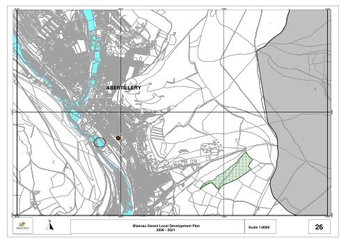
CBUndCFCRUndPath (um)CRCFWest ViewAberti leryBrynLyndeeTheTwoJaysCartrefFBTheBMROADPath (um)TrackPath (um)BM 260.77mElSubStaUndTrackCWPath (um)UndDefS TkTrackTrackDefHIGH STREETB 4471321000 322000 323000 324000ED BdyAmber LeighUn dHo lybrook427.0mThe CroftAsh ValeRose Heyworth EstateIssuesRadnor HouseTrackThe BungalowPath (um)CollectsTrackPen-y-BrynWaun WenVALLEY VIEW ROADED BdyBLAENAUGWENTSandridgeTy GwynCEFN CRESCENTUndCF PIssuesTrackDuffryn CottagesSunburyA 467Path (um)Recreation GroundBrynterionNew BungalowTrega ronRhiw LladronIssuesWestbrookSinksBundoranMontrefaComprehensive SchoolSpringfieldCyn CoedPath (um)DUFFRYN ROADAllotment GardensIssuesGarthJocelynPath (um)Co Const, Asly Const, UA & C BdyJacarandaBungalowsDanileaThe PinesCraig yJoranBryngwynCaldenPonderosaRoanneWillowbrookGelli-CrugInfants SchoolCar ParkFfynnonPath (um)AllotmentBrooklandsGardensTy-NiHEOL GELLI CRUG /264.26mIssuesROCH STREETAbertilleryPrimary SchoolGELLI-CRUGPath (um)CLARENCE STREETUndRecreation GroundTrack264.6mTennisPlaygroundCourtAllotmentGardensNEWA L STREETED BdyUndADAM STREETLynncottPath (um)Path (um)Path (um)Path (um)Cwm SychanTrackHill ViewBryn SiriolAvalonFLORENCECLOSEABERTILLERY(ABERTYLERI)TrackAllotmentGardensTrackBISHOP STREETCwmsychan Brook260.9mRhiw Park QuarryPath (um)RHIW-PARK ROADUndQuarry(disused)(disused)Path (um)459.3mPath (um)TrackPath (um)ABERTILLERYRHIW PARKRhiw-ParkED Bdy(Rhiw-Parc)TrackHillmanBungalowPath (um)Path (um)Path (um)Path (um)Track460.8mPath (um)Sheep PensPondTrackNant y Groes468.4mIssuesTrackPath (um)482.1mTrackBM 488.01m470.9mTrackCo Const, Asly Const, UA & C Bdy471.5mCoed y GilfachUndPEN-RHIW-GARREG ROADThe SpinneyPENRHIWGARREGPANT-Y-PWDYNDARREN ROAD468.4mBM 463.97mCwm Nant-y-groesPath (um)TrackPath (um)Path (um)Cwm Nant-y-groesCraig yr ArailCoetgaeCraig yr ArailSIX BELLSn203000 204000203000 204000Cwm Nant-y-groesPath (um)321000 322000 323000 324000STREETA 467<strong>Blaenau</strong> <strong>Gwent</strong> Local Development PlanScale 1:80002006 - 202126+ Crown copyright and database rights 2011 Ordnance Survey LA09002L + Hawlfraint y Goron a hawliau cronfa ddata 2011 Arolwg Ordnans LA09002L