
Create successful ePaper yourself
Turn your PDF publications into a flip-book with our unique Google optimized e-Paper software.
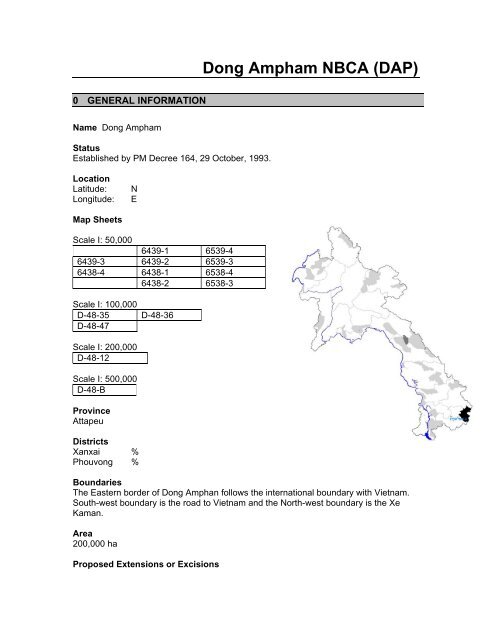
<strong>Dong</strong> <strong>Ampham</strong> <strong>NBCA</strong> (<strong>DAP</strong>)0 GENERAL INFORMATIONName <strong>Dong</strong> <strong>Ampham</strong>StatusEstablished by PM Decree 164, 29 October, 1993.LocationLatitude:Longitude:NEMap SheetsScale I: 50,0006439-1 6539-46439-3 6439-2 6539-36438-4 6438-1 6538-46438-2 6538-3Scale I: 100,000D-48-35D-48-47D-48-36Scale I: 200,000D-48-12Scale I: 500,000D-48-BProvinceAttapeuDistrictsXanxai %Phouvong %BoundariesThe Eastern border of <strong>Dong</strong> Amphan follows the international boundary with Vietnam.South-west boundary is the road to Vietnam and the North-west boundary is the XeKaman.Area200,000 haProposed Extensions or Excisions
Reasons for Extensions or ExcisionsThis would incorporate a substantial tract of dry dipterocarp and mixed deciduousforests, habitats very poorly represented in the <strong>NBCA</strong> at present. These areas areutilised by several key species such as Elephant, large cats, Gaur and possibly Banteng.There are no permanent settlements in this area, and its designation would provide theopportunity to link <strong>Dong</strong> Amphan with the Nam Kong Provincial Protected Area to thesouth-west and become part of a trans-border protected area with Cambodia andVietnam.Access<strong>Dong</strong> Amphan is located in the north-east of Attapeu Province. It is very remote andmountainous. Access is mainly limited to dry season only although this can still behazardous and time consuming.The two main arteries of access to <strong>Dong</strong> Amphan are the Xe Kaman and the Xe Xou,both of which are navigable by boat for a considerable distance (there are impassablerapids on both rivers approximately 35km from the Attapeu Plain/Western hills interface).Two dirt roads roughly follow these two rivers. The road from Attapeu to Xanxai districtcan be used as the main access route to the northern section of the <strong>NBCA</strong>. From thevillage of Ban Hin Dam, access is by boat up the Xe Kaman as far as the Hua Tat Pohrrapids, a rocky bottleneck. From here, and points to the south-west of the Xe Kaman, thecore of the <strong>NBCA</strong> is only accessible by foot. A network of well-established walking trailsexists, interconnecting villages.Access to the southern section of the <strong>NBCA</strong> is by boat up the Xe Xou. A dirt road joinsAttapeu with the Vietnamese border, following the Xe Xou for a short while. However, itis only seasonally passable in large trucks with a high wheel base, even at the height ofthe dry season, because the route involves fording the Xe Kaman. The Xe Xou isnavigable beyond Ban Keng Maw, although there are strong rapids just west of BanAntoum which are only navigable with difficulty. The Xe Xou is eventually unavailableupstream from Ban Keng Maw (Exact location not known). Trails follow the Xe Xou’snorthern and southern banks from Ban Keng Maw, and also penetrate into the <strong>NBCA</strong>interior.Stakeholder Villages and PopulationDistrict No. of Villages No. of Villages by type PopulationI II III IVSaysetha 32 25,512Samakkhisay 23 19,327Sanamsay 50 19,696Xanxai 56 12,329Phouvong 27 10,318TOTAL 188 87,182Population growth is estimated at 2.2% per year. Population density of 8 persons/km inthe province (March 1995, Census).
Principal Local Resource UsesEthnic CompositionAttapeu province has a majority of Lao Theung people, with Lao Loum making up only34% of the population. In the mountainous areas, the Lao Theung represent almost100% of the population.Ethnic group Nos. of villages Main LocationLao Loum 40 PlainLave (Laway - Brau) 44 Plain, Phouvong MountainsTalieng 34 Xanxai MountainsOy 23 Plain, near Phou LouangAlak 17 Xanxai MountainsSou 14 PlainNge 9 Xanxai MountainsCheng 3 PlainLoven 3 Edge of Bolovens PlateauNya Hon 2 Edge of Bolovens PlateauTa Oy 1 Plain2 BRIEF HISTORYThere has been no previous management in <strong>Dong</strong> Amphan <strong>NBCA</strong>. There is currently aDAFO outpost in Xanxai District, but no direct <strong>NBCA</strong> activities have occurred.3 ECOLOGYPhysical Features<strong>Dong</strong> Amphan is situated in the Annamite Chain mountains that run along the Lao PDRand Vietnamese border. These mountains are steep and rugged and give rise tonumerous streams and rivers, which create small floodplain areas. The Nong Fa orcrater lake is situated within the boundaries of the <strong>NBCA</strong>.The geology of the region is composed of clays, sandstone and limestone.ElevationElevation ranges from ca.120m in Attapeu lowlands to 2,052 m at Phou Pengmun, in thenorth-east of the protected area in the Annamite Chain bordering Vietnam.ClimateMain Forest TypesAccording to WCS, there are a wide variety of habitat types found in <strong>Dong</strong> Amphan.These habitats include:Lowland evergreen and semi-evergreen, mixed deciduous and dry dipterocarp forests;Hill evergreen and semi-evergreen and fagaceous forests;Dry, temperate-like upland coniferous and broadleaf woodland;
A mosaic of secondary forest and shifting cultivation.Other Habitat FeaturesDue to extensive bombing during the Indochina war (Two main trails through the <strong>NBCA</strong>,acting as main arteries of the Ho Chi Minh trail), <strong>Dong</strong> Amphan contains some bombcraters and UXO.Recorded Vertebrates 1MAMMALSCommon Name Scientific Name NationalPriorityGlobalThreatCategoryLao RiskCategoryDouc Langur Pygathrix nemaeus HNP EN ARLWhite-Cheeked Crested Hylobates leucogenys HNP DD PARLGibbonYellow-Cheeked Crested Hylobates gabriellae INP DD LKLGibbonSun Bear Ursus malayanus HNP DD ARLOriental Small-Clawed Aonyx cinerea HNP GNT ARLOtterFishing Cat Prionailurus viverrinus INP GNT LKLClouded Leopard Pardofelis nebulosa HNP VU ARLTiger Panthera tigris ANP EN ARLAsian Elephant Elephas maximus HNP EN ARLGaur Bos gaurus HNP VU ARLPig Tailed Macaque - VU PARLHog Badger - 0 LKLSambar - 0 PARLLarge-antlered Muntjac - n/a PARLSouthern Serow - VU PARLBIRDSCommon Name Scientific Name NationalPriorityGlobalThreatCategoryLao RiskCategoryGreat Hornbill HNP 0 ARLMasked Finfoot HNP VU ARLRiver Lapwing INP 0 ARLLesser Fish Eagle INP GNT ARLWoolly-necked Stork HNP 0 ARLSiamese Fireback Lophura diardi - VU PARL1 See priority/ threat/ risk classification key at the end of this section.
White-bellied Woodpecker - 0 PARLRed-collared Woodpecker Picus rabieri - VU 0Brown Hornbill Ptilolaemus tickelli - NT PARLWreathed Hornbill Rhyticeros undulatus - 0 ARLSpot-bellied Eagle Owl - GNT PARLYellow-vented Green- GNT 0PigeonGreen Imperial Pigeon - 0 ARLBlue-rumped Pitta - GNT PARLBar-bellied Pitta Pitta ellioti - GNT PARLSwinhoe’s Minivet - GNT 0Golden-crested Myna - 0 PARLWire-tailed Swallow - 0 PARLBlack-hooded Laughing- VU PARLThrushGrey-faced Tit Babbler Macronous kelleyi - GNT 0CLASSIFICATION KEYNational Priority CategoriesANP: Acute National Priority; HNP: High National Priority; INP: Intermediate National PriorityGlobal Threat Categories0: not listed as of concern; DD: data deficient; GNT: globally near-threatened; GT-CR: globally threatened -critical; GT-EN: globally threatened - endangered; GT-VU: globally threatened - vulnerable; n/a: notapplicable.Lao Risk Status0: not at risk in Lao PDR; ARL: at risk in Lao PDR; CARL: conditionally at risk in Lao PDR; LKL: little knownin Lao PDR; n/a: not applicable; PARL: potentially at risk in Lao PDR.4 PRINCIPAL CONTRIBUTIONS TO THE <strong>NBCA</strong> SYSTEMBiodiversity ValuesThe biodiversity value in <strong>Dong</strong> Amphan is great due to the remote location, ruggedterrain and broad suite of habitats. Numerous key species (species of high conservationvalue) of birds and mammals are found in <strong>DAP</strong> with 84 mammal species and 280 birdspecies confirmed or provisionally identified.In 1994-1995 a biological study of the Xe Kaman and Xe Xou found them to support avery high fish diversity, possibly as many as 300-400 species, including severalthreatened taxa. This may place the two rivers amongst the most important in Indochinain terms of fish diversity.There have also been numerous villager reports of Siamese Crocodile, a criticallyendangered reptile, from both the Xe Kaman and Xe Xou river systems.
Watershed ValuesThe <strong>NBCA</strong> region supports numerous watercourses, which drain westwards from thetwo main rivers of Xe Kaman and Xe Xou into the Xe Kong in the west. A biologicalsurvey of the Xe Kaman and Xe Xou places these two rivers amongst he most importantin Indochina in terms of fish biodiversity. The Xe Kaman, close to the Vietnameseborder, is currently being considered as a potential dam site.Cultural ValuesXanxai and Phouvong Districts are home to numerous distinct ethnic groups.Recreation & Tourism ValuesPrincipal Threats• The most immediate and serious threats to the <strong>NBCA</strong> are hunting and other wildlifeextraction, particularly for trade. This comprises two distinct forms; subsistence andcommercial. This is potentially the most threatening and damaging as it targets manykey species such as Tigers, Douc Langurs and Buff-cheeked Gibbon. There is alarge number of trans-border incursions by both the Lao and the Vietnameseexchanging and bartering wildlife and its derivatives for a wide variety of other goods.• NTFP collection. Much of this threat comes from Vietnam. Rattan collection issevere, especially along the eastern border with Vietnam, and will probably increaseas roads are finished that connect Lao with Vietnam. “Mai Dam” (black wood), thefungus infected heartwood of Aquilaria (Thymeleaceae) is important commerciallyand sold to Vietnam.• Unexploded Ordinance (UXO) from the Indochina War is a major threat to the peopleand large animals in the area. UXO may hinder conservation efforts as it limits travelof both villagers and management staff.• Other threats include shifting cultivation and swidden agriculture, which areincreasing due to population pressures and increased poverty.• Construction of the Xe Kaman hydropower dam will inundate much of the old-growthevergreen/semi-evergreen forest in the Xe Kaman basin. This is the area with thehighest biodiversity conservation value.5 CURRENT MANAGEMENTContactRoland Yves Tel. (856) 21 216080Programme Co-ordinator Fax. (856) 21 216080WWF Lao Project OfficeEmailP.O. Box 7871VientianeLao P.D.R..Khamdy, Head of PAFO Tel. (856) 31 212 450Sukkaseum, Head of PFO Tel. (856) 31 212 450Subanh, Head of <strong>Dong</strong> Amphan <strong>NBCA</strong> Tel. (856) 31 212 450
StaffingTwo staff members (as of October 1999)Management StructureNo significant organisational structure currently existsBuildingsFinancial Support and TrainingCurrent Management Priorities• To establish an <strong>NBCA</strong> presence in Xanxai District• To involve villagers in participatory resource management. This involves participatoryresource assessments (PRAs) and flora and fauna surveys.• Initial steps in land use planning (village maps, etc)• The development and training of a provincial <strong>NBCA</strong> management team.Possible Research Topics• Conduct further research into uses of wildlife and its derivatives and NTFP’s so thatstructured management opportunities exist and that alternatives can be suggested toprovide alternative incomes and support.Other Projects Active in the Area• World Wide Fund for Nature (WWF): They are presently formulating plans formanagement of the Nam Ghong Proposed Provincial Protected area.• Lao Red Cross: They have been assisting with flood damage control and theteaching of first aid and HIV/AIDS.• Health Unlimited (HU): They supply medical assistance and facilities to remote andisolated villages.• UXO Clearance and Handicap International: Although the province was heavilyaffected by UXO, the province is deemed less of a priority than its neighbouringprovinces due to its inaccessibility.• Austral-Lao Hydropower company: Currently in survey and negotiation phases withLao Government on construction of a dam on the Xe Kaman.• DAEWOO: The Korean firm have been in Attapeu since 1994 and have nowcompleted the Houai Ho Power Station, 37km towards Xe Kong from Attapeu town.• <strong>Dong</strong> Ah: Another Korean firm promoting 6 dams on the Bolovens plateau, located17km from Attapeu town.6 REPORTS AND PUBLICATIONS1) Davidson, P., Robichaud, W., Tizard, R., Vongkhamheng, C. and Wolstemcroft, J.(1997). Wildlife and Habitat Survey of <strong>Dong</strong> Amphan and Phou KathongProposed NCBA, Attapeu Province, Lao PDR. WCS, Lao PDR.2) Goudineau, Y. (ed.; 1997). Resettlement and Social Characteristics of New Villages:Basic Needs for Resettled Communities in Lao PDR. Volume 2. UNDP, Lao PDR.
3) Handicap International (1997). Province and District Report; Province of Attapeu(17). National Study on the Socio-economic Impact of Unexploded Ordanance. LaoPDR.4) Roberts, T. and Baird, I. (1995). Rapid Assessment of Fish and Fisheries for the XeNam Noy – Xe Pian Hydroscheme in Southern Lao PDR. WCS, Vientiane.5) SIDA (1999). Proposal to Government of Lao. WWF Sweden.