here (PDF file) - ETSI Agronomos - Universidad Politécnica de Madrid
here (PDF file) - ETSI Agronomos - Universidad Politécnica de Madrid
here (PDF file) - ETSI Agronomos - Universidad Politécnica de Madrid
- No tags were found...

Create successful ePaper yourself
Turn your PDF publications into a flip-book with our unique Google optimized e-Paper software.
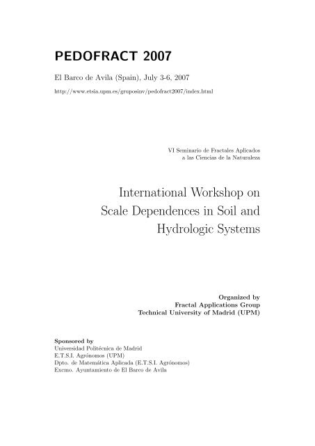
PEDOFRACT 2007El Barco <strong>de</strong> Avila (Spain), July 3-6, 2007http://www.etsia.upm.es/gruposinv/pedofract2007/in<strong>de</strong>x.htmlVI Seminario <strong>de</strong> Fractales Aplicadosa las Ciencias <strong>de</strong> la NaturalezaInternational Workshop onScale Depen<strong>de</strong>nces in Soil andHydrologic SystemsOrganized byFractal Applications GroupTechnical University of <strong>Madrid</strong> (UPM)Sponsored by<strong>Universidad</strong> Politécnica <strong>de</strong> <strong>Madrid</strong>E.T.S.I. Agrónomos (UPM)Dpto. <strong>de</strong> Matemática Aplicada (E.T.S.I. Agrónomos)Excmo. Ayuntamiento <strong>de</strong> El Barco <strong>de</strong> Avila
2 LIST OF PARTICIPANTS 4A. Paz González, <strong>Universidad</strong>e da Coruña (Spain).tucho@udc.esE. Perfect, University of Tennessee (U.S.A.).eperfect@utk.eduO. Salazar, Swedish U. Agr. Sci. (Swe<strong>de</strong>n).Osvaldo.Salazar@mv.slu.seJ.M. Rey, <strong>Universidad</strong> Complutense <strong>de</strong> <strong>Madrid</strong> (Spain).j-man@ccee.ucm.esM. Reyes, <strong>Universidad</strong> Politécnica <strong>de</strong> <strong>Madrid</strong> (Spain).mreyes@fi.upm.esF. San José, <strong>Universidad</strong> Politécnica <strong>de</strong> <strong>Madrid</strong> (Spain).fernando.sanjose@upm.esS.K. Sharma, Dehradum (India).SKS105@rediffmail.comS. Stanchi, Universitá di Torino (Italy).silvia.stanchi@unito.itT. Steenhuis, Cornell University (U.S.A.).tss1@cornell.eduM. Sukop, Florida International University (U.S.A.).sukopm@fiu.eduF. J. Taguas, <strong>Universidad</strong> Politécnica <strong>de</strong> <strong>Madrid</strong> (Spain).subdirector.si.agronomos@upm.esM. Tuller, University of Arizona, (U.S.A.).mtuller@cals.arizona.eduT. Vanwalleghem, University of Cordoba, (Spain).ag2vavat@uco.es
3 SCIENTIFIC PROGRAM 53 Scientific programInvited talks:• J. Crawford, University of Abertay (U.K.):1. “The origin and consequences of fractal structure in soils”.2. “Self-similar drainage in fractal porous media”.• J. V. Girál<strong>de</strong>z, University of Córdoba (Spain):1. “Soil recharge processes at differente scales”.2. “Particle displacements in erosion processes”.• J. Hopmans, University of California Davis (U.S.A.):“Mo<strong>de</strong>l Complexity, Space-Time Resolution and Input Uncertainty inHydrosalinity Mo<strong>de</strong>ling”.• Y. Pachepsky USDA-ARS (U.S.A.):1. “Scale <strong>de</strong>pen<strong>de</strong>nt complexity in soil and hydrologic systems andmo<strong>de</strong>ls”.2. “Scale-<strong>de</strong>pen<strong>de</strong>nt uncertainty in soil hydrologic systems”.• T. Steenhuis, Cornell University (U.S.A.):1. “What controls direct runoff at various scales?”.2. “Scale <strong>de</strong>pen<strong>de</strong>ncies in colloid transport in soils”.
3 SCIENTIFIC PROGRAM 7Posters session 1:• C. Pare<strong>de</strong>s-Bartolomé: “MS2Z - A multiscale morphostructural zoningmethod to i<strong>de</strong>ntify seismo-volcanic”.• J. Paz-Ferreiro: “Multifractal characterization of Hg injection curvesfrom different soil types”.• J. Paz-Ferreiro: “Characterizing Variability of Soil Particle Size Distributionsby Multifractals”.• A. Paz-Gonzalez: “Graph theory <strong>de</strong>fining rainfall regions with non local<strong>de</strong>pen<strong>de</strong>nce”.• O. Salazar: “Estimating soil hydraulic properties for upscaling fieldscalemo<strong>de</strong>ls”.Posters session 2:• J. Grau: “Quantifying a soil pore network in 3-d images: multifractalspectrum through wavelet approach ”.• J.J. Ibáñez: “The Fractal distribution of pedotaxa in Europe”.• C. Pare<strong>de</strong>s-Bartolomé: “Fractal merging of morphotectonic lineaments.The application to Deception Island”.• J. Paz-Ferreiro: “Fractal dimensions <strong>de</strong>rived from nitrogen adsorptionisotherms”.• J. Paz-Ferreiro: “Fractal and multifractal analysis of PSDs as affectedby soil management”.• A. Paz-Gonzalez: “Multifractal spectra of soil surface microrelief asaffected by DEM resolution”.
3 SCIENTIFIC PROGRAM 8SchedulePresentation of the conference: Monday, 9:15hTuesday 3 Wednesday 4 Thursday 5 Friday 69:30-10:15 Y. Pachepsky (1) T. Steenhuis (1) E. Perfect (1) E. Perfect (2)10:15-11:00 J. Hopmans J. V. Girál<strong>de</strong>z (1) T. Steenhuis (2) Y. Pachepsky (2)11:00-11:30 Coffee break11:30-12:15 J. Crawford (1) J. Crawford (2) J. V. Girál<strong>de</strong>z (2) M. Sukop (2)12:15-12:40 F. San José M. A. Martín M. Sukop (1) Closing session12:40-15:30 Lunch15:30-15:55 C. Pare<strong>de</strong>s C. García-Gutiérrez16:00-16:25 F. J. Jiménez-Hornero Spanish picnic J.J. Ibáñez16:30-16:55 S. K. Sharma (“merienda”) E. Palleja17:00-18:30 Poster session 1 Poster session 221:00 Social Dinner
4 SUMMARIES OF THE CONFERENCES 94 Summaries of the conferencesTuesday 3, 9:30–10:15Title: Scale-<strong>de</strong>pen<strong>de</strong>nt complexity in soil and hydrologic systems andmo<strong>de</strong>ls.Author: Y. Pachepsky.Complexity of soil and hydrologic systems is easy to perceive but is verydifficult to represent in mathematical terms. This causes the structural uncertaintyof mo<strong>de</strong>ls which introduces uncontrollable uncertainty in forecastresults. Various measures of system complexity have been proposed. The objectiveof this work is to review the complexity measures suitable for naturalhydrologic systems and hydrologic mo<strong>de</strong>ls and compare their application ina case study. Because of interrelation between soil/landscape structure andsoil/landscape hydrologic function, both complexity of structural arrangementand complexity of flow have to be consi<strong>de</strong>red in parallel. The soil-watersystem complexity arises from the complexity of arrangement of structuralunits and from the complexity of flow within and among the structural units.Introducing complexity measures is based on the premise that complexity isa property rather than a quality. Measuring complexity is closely related tothe practical questions of the best mo<strong>de</strong>ling practices that are ”What complexitydo we have?” and ”What complexity do we need?” We consi<strong>de</strong>r (a)complexity measures based on the relative differences between probabilitiesof the system states and (b) complexity measures based on relative differencesbetween probabilities of transitions from one state to another, and (c)complexity measures directly based on scale change. We use the metric entropyand the mean information gain as information content measures, andthe effective complexity and fluctuation complexity as complexity measures.Fractal dimensions are used as the complexity measures directly based onscale change. Having a complexity measure allows one address the effectof scale on complexity and to <strong>de</strong>termine whether the complexity of hydrologicsystems increases with the change in scale and whether the change incomplexity of mo<strong>de</strong>l parallels the change in complexity of soil hydrologic systems.We <strong>de</strong>monstrate the effect of the scale with runoff/precipitation datafrom four USDA ARS research watersheds. The runoff hydrologic regimesare more complex than precipitation regimes. The scale effect on complexity<strong>de</strong>pends on whether the scale change is reflected either in aggregationor in the change of parametric characterization. The complexity measurescan be used as useful indicators to <strong>de</strong>fine best mo<strong>de</strong>ling practices in soil andlandscape hydrology.
4 SUMMARIES OF THE CONFERENCES 10Tuesday 3, 10:15–11:00Title: Mo<strong>de</strong>l Complexity, Space-Time Resolution and Input Uncertainty inHydrosalinity Mo<strong>de</strong>ling.Author: J. Hopmans.Prediction of large-scale vadose zone solute transport is affected by errors dueto uncertainties in mo<strong>de</strong>l structure (mo<strong>de</strong>l complexity) and mo<strong>de</strong>l input (parametervalues, boundary and initial conditions). Selection of an appropriatelevel of mo<strong>de</strong>l complexity must consi<strong>de</strong>r these two sources of uncertainty.This paper illustrates this selection process for the prediction of root-zoneaverage salinity at different spatial scales, ranging from point to field scale.Salt transport is simulated with two mo<strong>de</strong>ls of different complexity. The first”complex” mo<strong>de</strong>l is based on the numerical solution of the one-dimensionalRichards and advection-dispersion equations. The second ”simple” mo<strong>de</strong>lconsists of newly <strong>de</strong>rived analytical solutions to the <strong>de</strong>pth-integrated flowand salt balance equations, assuming a time-invariant relationship betweensalt storage and drainage load. Statistical moments of root-zone averagesalinity predicted with the ”simple” and ”complex” mo<strong>de</strong>ls are compared fordifferent levels of mo<strong>de</strong>l input uncertainty, ranging from point scale (smalluncertainty) to field scale (large uncertainty). Results show that the ”complex”mo<strong>de</strong>l may be replaced by the ”simple” mo<strong>de</strong>l as long as mo<strong>de</strong>l inputuncertainty is large enough.Tuesday 3, 11:30–12:15Title: The Origin and Consequences of Fractal Structure in Soil.Author: J. Crawford.Particles in many soils are not randomly packed, but show power-law spatialauto-correlation that has been mo<strong>de</strong>lled using fractal geometry. This opensthe question of the origin of power-laws in soil and whether it matters forour un<strong>de</strong>rstanding of soil processes. In this presentation I will discuss theimportance of the scaling properties of soil for the physical, chemical and biologicalprocesses. Simple dynamical mo<strong>de</strong>ls will be introduced that attemptto explain the growth of spatial correlations over scales much larger than theparticle size. These mo<strong>de</strong>ls, and associated experiments, suggest that thedynamics is a consequence of the interaction between physical and biologicalprocesses in soil. The consequences of these interactions for the evolutionaryecology of soil are discussed in the context of the long-term sustainability ofthe ecosystem services it provi<strong>de</strong>s.
4 SUMMARIES OF THE CONFERENCES 11Tuesday 3, 12:15–12:40Title: Some preliminary results on the fitting of fractional mo<strong>de</strong>ls to soilcolumns experiments.Author: F. San José, Y. Pachepsky.Solute transport in soils and sediments is commonly simulated with theparabolic advective-dispersive equation, or ADE. Recently, a new mo<strong>de</strong>l wasproposed that <strong>de</strong>scribes the dispersion using fractional <strong>de</strong>rivatives, the fractionaladvective-dispersive equation or FADE, and contains ADE as a particularcase. Our objective was to test applicability of this mo<strong>de</strong>l to soilswith data from published miscible displacement experiments. The FADE,as a general mo<strong>de</strong>l that inclu<strong>de</strong>d ADE, accurately simulated experimentalbreakthrough curves. The Levy parameter varied with solute transport experimentalconditions, i.e. type of soil, type of tracer, flow velocity andsaturation <strong>de</strong>gree.Tuesday 3, 15:30–15:55Title: Towards a better un<strong>de</strong>rstanding of tectonic influence on shorelinecomplexity.Author: C. Pare<strong>de</strong>s-Bartolomé, C. Martínez, R. Pérez. J.L. Giner, R.<strong>de</strong> la Vega.The erosion causes that the morphology of the coastline <strong>de</strong>pends on the consi<strong>de</strong>redscale. The linear geological discontinuities on earth surface have beenfrequently recognized with scaling characteristics, particularly at DeceptionIsland (DI). Multivariate analysis has been done to <strong>de</strong>termine a possible influenceof lineaments multifractal characteristics on the shoreline fractalityat DI.Tuesday 3, 16:00–16:25Title: Multifractal analysis of flow in i<strong>de</strong>alised three-dimensional porousmedia.Author: F.J. Jiménez-Hornero, J.V. Girál<strong>de</strong>z, A.M. Laguna.The flow in i<strong>de</strong>alised three-dimensional porous media is <strong>de</strong>scribed by usingthe multifractal approach. The flow is simulated with a lattice mo<strong>de</strong>l in sixporous media with different porosities. The results show that the flows havea multifractal type of scaling that is stronger as the porosity <strong>de</strong>creases.
4 SUMMARIES OF THE CONFERENCES 12Tuesday 3, 16:30–16:55Title: Reservoir characterization of the ambikapur aquifer in central India.Author: S.K. Sharma.Poverty remains the biggest hurdle to reaching sustainable <strong>de</strong>velopment inIndia. Effective programs for poverty alleviation are urgently nee<strong>de</strong>d andwater plays a key role in this regard. On global scale it is assessed thatover the next two <strong>de</strong>ca<strong>de</strong>s, water use by human beings will increase by 40%and that 17% more water will be nee<strong>de</strong>d to grow more food for the increasingpopulation to attain water and food security. The World Water VisionCommission drew attention to the ”gloomy arithmetic of water” as water <strong>de</strong>mandwill out strip its availability. The scenario of water in India is equallygloomy. Despite India’s tremendous progress on all fronts after in<strong>de</strong>pen<strong>de</strong>ncein 1947, the fact remains that it is one of the poorest nation in the worldin terms of per capita income and energy consumption which is consi<strong>de</strong>redto be the gauge of the economic situation of any country. In case of India,it is nearly one tenth of the <strong>de</strong>veloped nations. If economic condition of itspeople is to be raised, then country has to boost its agriculture productionwhich is largely monsoon <strong>de</strong>pen<strong>de</strong>nt and to exploit its conventional and unconventionalenergy sources at a very rapid growth rate. The Ambikapur inCentral India is situated in a rural and backward area w<strong>here</strong> crops are totallymonsoon <strong>de</strong>pen<strong>de</strong>nt. However, with the initiatives of the State Government,25 boreholes in an area of about 25 square kilometers have been drilled upto a <strong>de</strong>pth of 500m and completed in the Gondwana sandstone. The waterquality and the discharge rates have been established to sustain the crops ofthe area which is the only livelihood of the local people, in case the monsoonfails. The hydraulic characterization of the aquifer namely, Transmissivity(T) and the Coefficient of Storage (S) were <strong>de</strong>termined following the graphicmethod of Jacob and Theis. The rate of discharge (Q) of the pumped wellwas estimated at 4. 05 x 103 cubic meters per second and the values ofother parameters like T at the well being 2.5 x 10³ square meters per secondand, T and S at the piezometric head being 1.56 x 10² square meters persecond and 5.8% respectively. The Interference Tests show that the reservoiris communicable. The measurements of bottom hole pressure indicate thatit was always greater than the hydrostatic pressure, t<strong>here</strong>fore, the wells willhave a self flow. The resi<strong>de</strong>ncy period of the water in the reservoir comes outto be nearly 30 to 40 years. The reservoir characteristics indicate that theAmbikapur aquifer offers vast water resource worth exploiting.
4 SUMMARIES OF THE CONFERENCES 13Wednesday 3, 9:30–10:15Title: What controls direct runoff?.Author: T. Steenhuis.Traditional methods for flood forecasting (such as the Soil Conservation ServiceCurve-Number (SCS-CN) runoff method) in ungauged watersheds predictingstorm flow based on total runoff and not on rainfall intensity areoften ridiculed by hydrologists for lack of theoretical background. Closerexamination of the un<strong>de</strong>rlying equations shows that for well-vegetated uplandwatersheds exhibiting saturated excess runoff, these equations have aphysical footing based on the assumption that all precipitation that fallson saturated areas runs off. The saturated areas expand in time. In thispresentation we will show that SCS-CN equation is part of a general set ofrelationships that predict runoff based on total storm precipitation with thecaveat that the runoff producing areas are in<strong>de</strong>pen<strong>de</strong>nt of the vegetation typeand hydrological soil classes and instead <strong>de</strong>pend on the average amount ofrainfall that can be stored in the soil before runoff occurs. At the same timefield observations suggest that vegetation type and runoff producing areasboth <strong>de</strong>pend on how wet or dry the particular location in the landscape is.T<strong>here</strong>fore, vegetation type is indirectly a good indication how much runoffone might expect in landscapes with salivation excess overland flow.Wednesday 4, 10:15–11:00Title: Soil recharge processes at different scales.Author: J.V. Girál<strong>de</strong>z.Both the rainfall excess generation and the water infiltration in a soil arevariable processes showing a fractal behaviour. The physical processes arediscussed applied to the analysis of soil water recharge in a sandy area w<strong>here</strong>the <strong>de</strong>pth to a shallow perched watertable is used to estimate the magnitu<strong>de</strong>of the events.Wednesday 4, 11:30–12:15Title: Self-Similar Drainage in Fractal Porous Media.Author: J. Crawford.The moisture release characteristic is arguably the most important metricin ecology. It controls the relative proportion of water and air in soil andconsequently plays a major role in affecting biological processes. The proportionalso affects diffusive and convective rate coefficients and t<strong>here</strong>fore the
4 SUMMARIES OF THE CONFERENCES 17Thursday 5, 16:30–16:55Title: Anisotropy and nonsimilarity in the fractal topography.Author: E. Palleja, A. Pra<strong>de</strong>lli, M. Paterlini.The fractal dimension of some topographical pro<strong>file</strong>s, bathymetry pro<strong>file</strong>s,coastlines and contours is analyzed. These representative lines of the terrainwere obtained from diverse sources, such as SRTM, COPLA, and satellite georeferenced images. The analysis leads to the verification of different aspectsof fractal properties of the topography.Friday 6, 9:30–10:15Title: Fractal and lacunarity analyses of rock fracture networks.Author: E. Perfect, A. Roy, W. M. Dunne, N. Odling, J. Kim.Lacunarity is a relatively new parameter for quantifying the clustering of spatialpatterns at different scales. It can be used to differentiate between fractalobjects with the same fractal dimension but different visual appearances. Inthe present study, we investigate the use of this parameter for analyzingsynthetic and natural fracture networks. The gliding-box algorithm was employedfor computing lacunarity, L, as a function of the box-size, r. Usingthis algorithm, we obtained lacunarity curves for a suite of synthetic fractalfracture patterns with a known fractal dimension (D), as well as for a set of7 nested rock fracture maps with similar D values ranging from 1.80±0.05to 1.84±0.04. Our results show that differences between synthetic patternswith the same fractal dimension and fracture porosity were most pronouncedwhen L values were <strong>de</strong>termined at intermediate box sizes. Although the naturalpatterns had similar fractal dimensions their fracture porosities variedbetween 5.7 and 10.1%. Lower lacunarity values were associated with higherfracture porosities. The L(r) functions also indicated that natural fracturesare more clustered at smaller observation scales. Further research is nee<strong>de</strong>dto explore the implications of this finding in terms of the mechanics of hierarchicalrock fracturing.Friday 6, 10:15–11:00Title: Scale-<strong>de</strong>pen<strong>de</strong>nt uncertainty in soil hydrologic systems.Author: Y. Pachepsky.Soils are in<strong>here</strong>ntly variable, and both soil hydraulic properties and hydraulicsoil variables are always known with some <strong>de</strong>gree of uncertainty. Wewill review the empirical information about sources and magnitu<strong>de</strong>s of the
4 SUMMARIES OF THE CONFERENCES 18scale-<strong>de</strong>pen<strong>de</strong>nt uncertainty in soil hydrology, and methods to address theuncertainty in predictive mo<strong>de</strong>ling. A summary of experimental data onscale-<strong>de</strong>pen<strong>de</strong>nt uncertainty in water retention, hydraulic conductivity, andsolute dispersivity will be presented. Measurement technique-related andavailability-related sources of uncertainty in hydraulic properties at typicalhydrologic operational scales will be discussed. Uncertainty in mo<strong>de</strong>ling resultswill be addressed as related to the calibration, the mismatch betweenmeasurement and mo<strong>de</strong>ling supports, and the mo<strong>de</strong>l structure. We will discussthe uncertainty introduced by the concept of representative elementaryvolume as applied to hierarchical pore spaces. Consequences of the omnipresenceof macropore flow and preasymptotic non-Fickean solute transport willbe expoun<strong>de</strong>d. Multimo<strong>de</strong>ling and ensemble forecasting will be advocatedas an explicit way to address the uncertainty in soil hydrologic systems.Friday 6, 11:30–12:15Title: Applying Lattice Boltzmann, Fractal, and Geostatistical Methods toKarst.Author: M. Sukop, H. Huang, P.F. Álvarez, K.J. Cunningham, C.D.Langevin.The karstic Biscayne Aquifer is a critical water source for millions of peoplein Florida. Aquifer characterization via X-ray tomography (CT) andborehole imaging is in progress. Lattice Boltzmann methods simulate flowin CT-<strong>de</strong>rived networks. Geostatistical and fractal approaches for expandingborehole images are consi<strong>de</strong>red. Methods for incorporating results intolarge-scale mo<strong>de</strong>ls are nee<strong>de</strong>d.
5 SUMMARIES OF THE POSTERS 195 Summaries of the postersPoster Session 1:Title: MS2Z - A multiscale morphostructural zoning method to i<strong>de</strong>ntifyseismo-volcanic.Authors: C. Pare<strong>de</strong>s-Bartolomé, J.L. Giner, R. Pérez, R. <strong>de</strong> la Vega, J.J.Martínez.The methodology <strong>de</strong>veloped <strong>here</strong> recognize: the morphostructural lineaments(mostly faults), their intersections, and the volumes within them (lithosphericblocks). It is presented with an application to Deception Island (South Shetland,West Antarctica) an active seismo-volcanic area. the achieved intensitydistribution the active areas are oriented and overlay some long morphotectoniclineaments.Title: Multifractal characterization of Hg injection curves from differentsoil types.Authors: J. Paz-Ferreiro, J.G.V. Miranda, M. Lado.Pore size distributions (PSDs) measured by Hg injection porosimetry of contrastingsoil types were analyzed by multifractal techniques. PSDs fromMollisols, Vertidols, Oxisols and Inceptisols sampled in Argentine, Braziland Spain could be quantified and separated by the properties of their singularityspectra. Trends in multifractal parameters were i<strong>de</strong>ntified and relatedto soil composition.Title: Characterizing Variability of Soil Particle Size Distributions byMultifractals.Authors: J. Paz-Ferreiro, E. Vidal.The aim of this study was to evaluate multifractals for assessing variabilityof particle size distributions. Samples were taken in two tillage experimentswith a split-plot block <strong>de</strong>sign. Particle size distributions analyzed by laserdiffractometry exhibited multifractal scaling. Parameters <strong>de</strong>rived from singularityspectra were useful for studying texture heterogeneity of experimentalplots.Title: Graph theory <strong>de</strong>fining rainfall regions with non local <strong>de</strong>pen<strong>de</strong>nce.Authors: A. Paz-Gonzalez, C. Santana, A.S. Fontes, J.G.V. Miranda.
5 SUMMARIES OF THE POSTERS 20The pattern of space <strong>de</strong>pen<strong>de</strong>nce in time series was explored with graphtheory. A set of spatially distributed rain stations <strong>de</strong>fined graph vertices; ifthe Pearson correlation coefficient of the historic data for two stations werehigher than a significant limit we consi<strong>de</strong>r an edge between them. Cumulativedistribution of edges length exhibits a power law, suggesting a non-metricfractal behaviour.Title: Estimating soil hydraulic properties for upscaling field-scale mo<strong>de</strong>ls.Authors: O. Salazar, I. Wesstrom, A. Joel.Upscaling of field-scale hydrological mo<strong>de</strong>ls has been proposed to estimatethe watershed response. The use of these mo<strong>de</strong>ls has been limited in theselarge areas of land by the high spatial variability of saturated hydraulic conductivity(Ks). The aim of this study was to evaluate the feasibility of runningDRAINMOD field-scale mo<strong>de</strong>l with Ks input resulting from ROSETTApedotransfer function mo<strong>de</strong>l.Poster Session 2:Title: Quantifying a soil pore network in 3-d images: multifractal spectrumthrough wavelet approach.Authors: J. Grau.Knowledge on soil pore geometry is important for un<strong>de</strong>rstanding soil processesas it controls the movement and storage of fluids on various scales.With the advent of mo<strong>de</strong>rn non-<strong>de</strong>structive tomography techniques t<strong>here</strong>have been many attempts ma<strong>de</strong> to analyze pore space features mainly concentratingon the visualization of soil structure. Multifractal formalism or thewavelet transform have revealed as useful tools in these cases w<strong>here</strong> highlycomplex and heterogeneous medium are studied. The field of 3D pore spaceanalysis opens a challenging opportunity to <strong>de</strong>velop techniques for quantifyingand <strong>de</strong>scribe pore space properties. One of these quantifications canbe the maximum <strong>de</strong>pth pore network (MD), analogous as the quantificationof the preferential flow paths. In this paper a variation of the wavelettransform modulo maxima (WTMM) method is presented. Based on a setof statistical measurements directly obtained from the Wavelet Analysis therange of scales to perform the multifractal analysis (MFA) of the MD is selected.Then WTMM is applied to <strong>de</strong>termine the multifractal behaviour of3D images of soil samples with 45 mm resolution (250x250x250 voxels) withdifferent porosities and spatial arrangements.
5 SUMMARIES OF THE POSTERS 21Title: The Fractal distribution of pedotaxa in Europe.Author: J.J. Ibáñez, R. Pérez.The authors carry out spatial distribution patterns of the most abundantpedotaxa in Europe (46 soil types), according to the European Soil Databasefollowing the box counting methods. Fractal analysis showed that all thepedotaxa tested fit very well to a power law with a coefficient regressionhighest than 0.999.Title: Fractal merging of morphotectonic lineaments. The application toDeception Island.Authors: C. Pare<strong>de</strong>s-BartoloméIn or<strong>de</strong>r to reveal a possible relationship between the scaling and spatialvariability in the fracture patterns with the spatial distribution of recentvolcanism at Deception Island the fractality of an improved cartography oftrace faults has been characterized. Several analyses have been performedto <strong>de</strong>scribe the fracture scaling: occurrence, aggregation, intensity, and sizedistribution.Title: Fractal dimensions <strong>de</strong>rived from nitrogen adsorption isotherms.Authors: J. Paz-Ferreiro, J.G.V. Miranda, M. Wilson, E. Vidal.Nitrogen adsorption isotherms were measured on two soils with contrastingspecific surface values. Data were analyzed with a fractal Frenkel-Halsey-Hill mo<strong>de</strong>l. Two main power law domains were i<strong>de</strong>ntified. Surface fractaldimension, Ds, ranged from 2.79 to 2.90 for the first domain and from 2.60to 2.68 for the second one. Values of Ds were not affected by differences insoil type and management.Title: Fractal and multifractal analysis of PSDs as affected by soilmanagement.Authors: J. Paz-Ferreiro, J.G.V. Miranda, M. Wilson, E. Vidal.Soil use intensity effects on pore size distributions (PSDs) were evaluated intwo soil types from Entre Rios, Argentine. Treatments inclu<strong>de</strong>d natural land,continuous pasture, crop-pasture rotation and continuous cropping. Fractaland multifractal indicators were computed from Hg porosimetry. Managementaffected some selected ranges of PSDs as well as values of fractal andmultifractal parameters.
6 SOCIAL PROGRAM 236 Social programOn Monday evening (July 2nd) after picking-up the workshop documentationand the hotel registration it will be offered a welcome cocktail at the HotelReal <strong>de</strong> Barco.On Wednesday (July 4th) we are planning an excursion to a pleasant areanear El Barco and have a “merienda” (spanish picnic).On Thursday evening (July 5th, 21:00 hours) we shall have a dinner offeredby the Excmo. Ayuntamiento <strong>de</strong> El Barco <strong>de</strong> Ávila at the Hotel Real <strong>de</strong>Barco.