here - South Ribble Orienteering Club
here - South Ribble Orienteering Club
here - South Ribble Orienteering Club

Create successful ePaper yourself
Turn your PDF publications into a flip-book with our unique Google optimized e-Paper software.
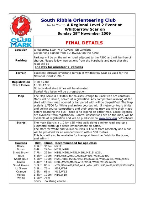
<strong>South</strong> <strong>Ribble</strong> <strong>Orienteering</strong> <strong>Club</strong>Invite You To A Regional Level 2 Event atWhitbarrow Scar onSunday 29 th November 2009FINAL DETAILSLocationParkingTerrainRegistrationStart TimesMapStartsCoursesBlackBrownShort BrownBlueShort BlueGreenShort GreenLt GreenOrangeYellowWhiteWhitbarrow Scar, W of Levens, SE LakelandCar parking signed from SD 452839 on the A590Parking will be on the minor road adjacent to the A590 and will be free ofcharge. Please follow instructions from the Marshalls and note that thisroad will beone way for orienteer's vehiclesExcellent intricate limestone terrain of Whitbarrow Scar as used for theNational Event in 20079.30-12.0010.30-12.30No individual start times will be allocatedSealed Map issue will be at registrationThe Map Scale is 1:10000 for courses Orange to Black with 5m contours.Maps will be issued, sealed at registration. Any competitors arriving at thestart with their map opened or tampered with will be disqualified. The Mapscale is 1:7500 for White and Yellow courses with 5 metre contours Whiteand yellow course competitors and their coaches may examine their mapsbefore boarding the bus. T<strong>here</strong> is no legend on either map. Loose legendsare available from registration. Control descriptions are on the map, will beavailable at registration and will be published on www.sroc.org beforehand.The main Start is a 1.0 km (25 min) walk along a minor road and up a150metre climb up a steep embankment on paths.The start for White and yellow courses is 1.5km from assembly and a buswill be provided for all competitors to within 500 metresThis bus will also be available for transport from the finish for the youngand infirm!!Dist. Climb Recommended for age class9.9km 365m M21L8.4km 240m M35L,M40L7.7km 235m M18L,M20L,M45L,M50L,M21S,W21L6.1km 190m M16,M55L,M60L,M35S,M40S,W35L,W40L5.5km 190m M65L,M18S,M20S,M45S,M50S,W18L,W20L,W45L,W50L,W21S4.4km 110m M70L,M55S,M60S,W16,W55L,W60L,W35S,W40S3.0km 85m3.1km 75m M14,W142.6km 65m M12,W121.6km 100m M10,W101.2km 75mSorry – no string courseM75L,M80,M65S,M70S,W65L,W70L,W75L,W80,W45S,W50S,W55S,W60S
PricesImportantSafety NotesFrom thePlanner andOrganiserAdult Pre-entry coursesShort green and above £11.00 (+£2.00 EOD)White, Yellow, Orange and L/green £7.00(Both above Less £2.00 BOF Discount)All Juniors £4.00. SI card hire availableThe terrain is very rocky over a wide area. Competitors should look out forgrykes - slits in the rock surface w<strong>here</strong> it is easy to step into. The area islimestone and t<strong>here</strong>fore can be slippery especially if conditions are wet.Also look out for some low vegetation which can hide the rock and slitsbelow. Another hazard is old tree stumps. Due to the rocky nature of theterrain it will be impossible to hang kites from canes or stakes. Kites in themain will be laid on the ground with the SI boxes and control numbersattached by a cord. Bracken has been marked on the map as wide greenlines but should not be used to accurately navigate from.T<strong>here</strong> are very steep and very high cliffs to the West and <strong>South</strong> of the area.Courses have been designed to take competitors away from these areas. Ifa competitor should become completely lost head in a generally easterndirection keeping to the open land. The major wooded areas to the NE ofthe map should also be avoided. T<strong>here</strong> are also many smaller cliffs andsteep scree slopes on the courses from the main start. Control connectinglines have not been diverted to avoid these obstacles.For courses from the main start, t<strong>here</strong> may be cows in the area – pleaseexercise due caution, and do not run close to them.The Yellow course unusually has a crossover and a short taped route.Please ensure that this is is explained younger competitors.Courses have also been designed to avoid any dubious wall crossings. Theconnection lines between controls have been bent to indicate the wallcrossings which are in the main stiles and gates. T<strong>here</strong> is a wall crossingnear the end of most longer courses w<strong>here</strong> the crossing is through a brokenwall. This will be taped around the gap in the wall. Damage must bereported upon finishing.Whistles Must be carried and will be checkedFull Leg cover is CompulsoryCagoules may be compulsory if weather is inclementThese checks could take place at any point between assembly andthe startMiscellaneousToilets will be situated in the assembly areaT<strong>here</strong> is no clothing depositSt John Ambulance will be in attendanceOfficials Planner Dave Hargreaves (SROC)Controller Ray Barnes (NOC)Organiser Tony Marlow (SROC) 01772 698918tonymarlow@sky.com<strong>Orienteering</strong> is an outdoor adventure sport- competitors are responsible fortheir own safety, and take part at their own risk.www.sroc.org