A Wearable Computer System with Augmented Reality to Support ...
A Wearable Computer System with Augmented Reality to Support ...
A Wearable Computer System with Augmented Reality to Support ...

Create successful ePaper yourself
Turn your PDF publications into a flip-book with our unique Google optimized e-Paper software.
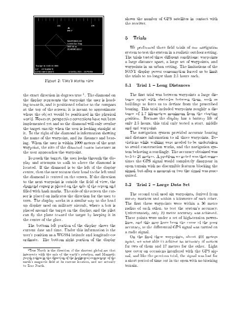
shows the number of GPS satellites in contact <strong>with</strong>the receiver.5 TrialsFigure 2: User's screen viewthe exact direction in degrees true 1 . The diamond onthe display represents the waypoint the user is heading<strong>to</strong>wards, and is positioned relative <strong>to</strong> the compassat the <strong>to</strong>p of the screen it is meant <strong>to</strong> approximatewhere the object would be positioned in the physicalworld. However, perspective corrections have not beenimplemented yet and so the diamond will only overlaythe target exactly when the user is looking straight atit. To the right of the diamond is information showingthe name of the waypoint, and its distance and bearing.When the user is <strong>with</strong>in 1000 meters of the nextwaypoint, the size of the diamond cursor increases asthe user approaches the waypoint.To reach the target, the user looks through the displayand attempts <strong>to</strong> walk <strong>to</strong> where the diamond islocated. If the diamond is <strong>to</strong> the left of the displaycentre, then the user rotates their head <strong>to</strong> the left untilthe diamond is centred on the screen. If the direction<strong>to</strong> the next waypoint is outside the eld of view, thediamond cursor is placed on the side of the screen andlled <strong>with</strong> hash marks. The side of the screen the cursoris placed on indicates the direction for the user <strong>to</strong>turn. The display works in a similar way <strong>to</strong> the headup display used on military aircraft, where a box isplaced around the target on the display, and the pilotcan y the plane <strong>to</strong>ward the target by keeping it inthe centre of the glass.The bot<strong>to</strong>m left portion of the display shows thecurrent date and time. Under this information is theuser's position as a WGS84 latitude and longitude coordinate.The bot<strong>to</strong>m right portion of the display1 True North is the direction of the shortest global arc thatintersects <strong>with</strong> the axis of the earth's rotation, and MagneticNorth points in the direction of the horizontal component oftheearth's magnetic eld at its current location, and not actually<strong>to</strong> True North.We performed three eld trials of our navigationsystem <strong>to</strong> test the system in a realistic outdoor setting.The trials tested three dierent conditions: waypointsa large distance apart, a large set of waypoints, andwaypoints in an urban setting. The limitations of theSONY display power consumption forced us <strong>to</strong> limitthe trials <strong>to</strong> no longer than 2.5 hours each.5.1 Trial 1 { Long DistancesThe rst trial was between waypoints a large distanceapart <strong>with</strong> obstacles between them, such asbuildings <strong>to</strong> force us <strong>to</strong> deviate from the prescribedbearing. This trial included waypoints roughly a distanceof 1.7 kilometres maximum from the startingposition. Because the display has a battery life ofonly 2.5 hours, this trial only tested a start, middleand end waypoint.The navigation system provided accurate bearingand distance information <strong>to</strong> all three waypoints. Deviationswhile walking were needed <strong>to</strong> be undertaken<strong>to</strong> avoid construction works, and the navigation systembehaving accordingly. The accuracy obtained was<strong>to</strong> 5 <strong>to</strong> 20 metres. A problem we noted was that sometimesthe GPS signal would completely disappear inopen terrain <strong>with</strong> no discernible features blocking thesignal, but after a moment ortwo the signal was reacquired.5.2 Trial 2 { Large Data SetThe second trail used six waypoints, derived fromsurvey markers and <strong>with</strong>in a kilometre of each other.The rst three waypoints were <strong>with</strong>in a 30 metreradius of each other, <strong>to</strong> test the system's accuracy.Unfortunately, only20 metre accuracy was achieved.These points were under a set of high-tension powerlines,and this may have been the cause of the pooraccuracy, as the dierential GPS signal was carried ona radio signal.On the nal three waypoints, about 400 metersapart, we were able <strong>to</strong> achieve an accuracy of metresfor two of them and 17 metres for the other. Lighttree cover on occasions interfered <strong>with</strong> the GPS signal,and like the previous trial, the signal was lost fora short period of time out in the open <strong>with</strong> no blockingterrain.