Application 12/01008/FUL Land at Manor Farm, Binfield Road ...
Application 12/01008/FUL Land at Manor Farm, Binfield Road ...
Application 12/01008/FUL Land at Manor Farm, Binfield Road ...

Create successful ePaper yourself
Turn your PDF publications into a flip-book with our unique Google optimized e-Paper software.
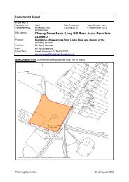
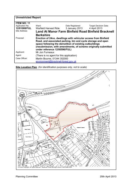
Unrestricted ReportITEM NO: 11<strong>Applic<strong>at</strong>ion</strong> No.<strong>12</strong>/<strong>01008</strong>/<strong>FUL</strong>Site Address:Proposal:Ward:Warfield Harvest RideD<strong>at</strong>e Registered:3 January 2013Target Decision D<strong>at</strong>e:4 April 2013<strong>Land</strong> At <strong>Manor</strong> <strong>Farm</strong> <strong>Binfield</strong> <strong>Road</strong> <strong>Binfield</strong> BracknellBerkshireErection of 24no. dwellings with vehicular access from <strong>Binfield</strong><strong>Road</strong>, and associ<strong>at</strong>ed parking, bin and cycle storage and openspace following the demolition of existing outbuildings(resubmission, with amendments, of scheme originally submittedunder reference <strong>12</strong>/00596/<strong>FUL</strong>)Applicant: Mr Jon FurneauxAgent:(There is no agent for this applic<strong>at</strong>ion)Case Officer: Martin Bourne, 01344 352000environment@bracknell-forest.gov.ukSite Loc<strong>at</strong>ion Plan (for identific<strong>at</strong>ion purposes only, not to scale)© Crown Copyright. All rights reserved. Bracknell Forest Borough Council 100019488 2004Planning Committee 25th April 2013
1 RELEVANT PLANNING HISTORY (If Any)<strong>12</strong>/00596/<strong>FUL</strong> Valid<strong>at</strong>ion D<strong>at</strong>e: 25.07.20<strong>12</strong>Erection of 24 dwellings with vehicular access from <strong>Binfield</strong> <strong>Road</strong>, and associ<strong>at</strong>edparking, bin and cycle storage and open space following the demolition of existingoutbuildings.Refused2 RELEVANT PLANNING POLICIESKey to abbrevi<strong>at</strong>ionsBFBCSBFBLPRMLPWLPSPGSPDMPGDCLGNPPFCore Str<strong>at</strong>egy Development Plan DocumentBracknell Forest Borough Local PlanReplacement Minerals Local PlanWaste Local Plan for BerkshireSupplementary Planning GuidanceSupplementary Planning DocumentMinerals Planning GuidanceDepartment for Communities and Local GovernmentN<strong>at</strong>ional Planning Policy FrameworkPlan Policy Description (May be abbrevi<strong>at</strong>ed)BFBLP EN1L Protecting Tree And Hedgerow CoverBFBLP EN2L Supplementing Tree And Hedgerow CoverBFBLP EN3L N<strong>at</strong>ure Conserv<strong>at</strong>ionBFBLP EN8L Dev On <strong>Land</strong> Outside SettlementsBFBLP EN14 River QualityBFBLP EN20 Design Consider<strong>at</strong>ions In New DevelopmentBFBLP EN22 Designing For AccessibilityBFBLP H5L New Dwellings Outside SettlementsBFBLP H8L Affordable HousingBFBLP H14 Accessible HousingBFBLP M4L Highway Measures New DevelopmentBFBLP M8 Public TransportBFBLP M9 Vehicle And Cycle ParkingBFBLP R4 Provision Of Open Space Of Public ValueBFBLP M6 Cycling And WalkingBFBCS CS1 Sustainable Development PrinciplesBFBCS CS2 Loc<strong>at</strong>ional PrinciplesBFBCS CS5 <strong>Land</strong> north of Whitegrove and Quelm ParkBFBCS CS6 Limiting the Impact of DevelopmentPlanning Committee 25th April 2013
BFBCS CS7 DesignBFBCS CS8 Recre<strong>at</strong>ion and CultureBFBCS CS9 Development on <strong>Land</strong> Outside SettlementsBFBCS CS10 Sustainable ResourcesBFBCS CS<strong>12</strong> Renewable EnergyBFBCS CS14 ThamesBasinHe<strong>at</strong>hs SpecialProtectionAreaBFBCS CS15 Overall Housing ProvisionBFBCS CS16 Housing Needs of the CommunityBFBCS CS17 Affordable HousingBFBCS CS23 TransportBFBCS CS24 Transport and New Development3 CONSULTATIONS(Comments may be abbrevi<strong>at</strong>ed)The Environment AgencyNo objection to the proposal subject to the imposition of a number of conditions inrel<strong>at</strong>ion to flood risk and biodiversity.Berkshire ArchaeologyNo objection subject to imposition of a condition to investig<strong>at</strong>e the site forarchaeological remains prior to or during development.Environmental Health and SafetyNo objection subject to imposition of a condition to secure Working Method St<strong>at</strong>ementto control the environmental effects of the demolition and construction work.Conserv<strong>at</strong>ion OfficerComments included in report.Transport<strong>at</strong>ion OfficerNo objection subject to conditions/s106 agreement to secure contributions.Warfield Parish CouncilRecommend refusal:1. The form<strong>at</strong>ion of a new access in close proximity to the access to Jocks LaneRecre<strong>at</strong>ion Ground, which is already a very well-used and busy public amenity, wouldresult in conflicting vehicle movements which would adversely affect the safety andflow of traffic on <strong>Binfield</strong> <strong>Road</strong>.Planning Committee 25th April 2013
The Cut, to the north of which lies Garth Meadow POS on land which rises up toHarvest Ride.Semi-detached houses <strong>at</strong> <strong>Manor</strong> Close lie to the south of the western part of theapplic<strong>at</strong>ion site with allotments and a parking court to the east.The site generally falls gently to the north towards The Cut. The bulk of the site iscurrently used as paddocks although the north-western corner forms part of the gardenarea of <strong>Manor</strong> <strong>Farm</strong>. The site contains a number of outbuildings including stables,open storage shelters and a reconstructed barn.There are a number of m<strong>at</strong>ure trees on the site's boundaries.iii) BACKGROUNDA full planning applic<strong>at</strong>ion for the erection of 24 dwellings (<strong>12</strong>/00596/<strong>FUL</strong>) was refusedlast year on the following grounds:-- harmful impact on the setting of <strong>Manor</strong> <strong>Farm</strong>- uns<strong>at</strong>isfactory form of development to the detriment of the character and amenities ofthe area because:-- overly uniform streetscene;- impact on property in <strong>Manor</strong> Close- uns<strong>at</strong>isfactory design of the footp<strong>at</strong>h link to Anneforde Place- shortcomings in highway design details- possible harm to biodiversity.The current applic<strong>at</strong>ion seeks to address these concerns.iv) PLANNING CONSIDERATIONS(1) Principle of Development and Issue of ComprehensivenessThe site lies on land outside a settlement as identified in the Bracknell ForestProposals Map. The proposal for residential development is contrary to developmentplan policies applying to such an area.The site, however, forms part of the land identified in Core Str<strong>at</strong>egy DPD Policy CS5and the emerging Site Alloc<strong>at</strong>ions Development Plan Document (SADPD) Policy SA9to accommod<strong>at</strong>e a large mixed-use urban extension north of the neighbourhoods ofWhitegrove and Quelm Park in the Parish of Warfield. Guidance on the developmentof this area is provided by the Warfield SPD.At para 4.48 the SPD recognises th<strong>at</strong> the <strong>Manor</strong> <strong>Farm</strong> area is somewh<strong>at</strong> isol<strong>at</strong>ed fromthe main development but st<strong>at</strong>es th<strong>at</strong> it must contribute to the policies and designprinciples set out in the SPD. Appendix 3 of the Warfield SPD - Implement<strong>at</strong>ion andSequence Plan - st<strong>at</strong>es th<strong>at</strong> <strong>Manor</strong> <strong>Farm</strong> can come forward separ<strong>at</strong>ely subject to theeffective provision of infrastructure and services in accordance with the SPD. Figure 5of the SPD - Schedule of accommod<strong>at</strong>ion - suggests th<strong>at</strong> the site can accommod<strong>at</strong>e 22dwellings.In the light of the above the principle of residential development on the site isconsidered to be acceptable.(2) Impact Upon the Character and Cppearance of the AreaPlanning Committee 25th April 2013
The proposal will clearly have an urbanising effect on the site and the surroundingarea, contrary to current development plan countryside policies. As outlined above,however, the applic<strong>at</strong>ion site lies within an area alloc<strong>at</strong>ed for development. In thiscontext the following comments are made on the proposed layout of the development.General form of developmentPara 4.49 of the Warfield SPD sets out the design principles for <strong>Manor</strong> <strong>Farm</strong>, some ofwhich are shown on Figure 4 - Concept Plan.Taking these into consider<strong>at</strong>ion the general form of development with an access roadrunning through the middle of the development with dwellings fronting on to it, withhouses overlooking the proposed SANG/POS area which is proposed to be loc<strong>at</strong>ed onthe north-eastern part of the site, is considered to be acceptable. The Warfield SPDst<strong>at</strong>es th<strong>at</strong> some dwellings should front on to <strong>Binfield</strong> <strong>Road</strong> <strong>at</strong> the south-west end of thesite. The form of development proposed on this part of the site (with houses/fl<strong>at</strong>sgenerally backing on to the road) is considered to be acceptable, as submitted,provided th<strong>at</strong> the existing veget<strong>at</strong>ion is substantially retained giving a soft edge to thisapproach to Bracknell.The proposed development provides for the retention of most of the principal trees onthe site's boundaries. The proposed access onto <strong>Binfield</strong> <strong>Road</strong> will result in the loss anoak tree. Space is provided within the layout for replacement trees to be planted closebyto mitig<strong>at</strong>e this loss. A small number of ornamental trees will also be lost further intothe site, together with an oak tree situ<strong>at</strong>ed next to The Cut which is to be felled due toits unsafe condition. Again the landscape str<strong>at</strong>egy submitted with the applic<strong>at</strong>ionshows scope for replacement tree planting and overall the impact of the proposal ontrees on and adjoining the site is considered to be acceptable.Impact on the setting of the listed farmhouse <strong>at</strong> <strong>Manor</strong> <strong>Farm</strong><strong>Manor</strong> <strong>Farm</strong> house is a grade II listed building. Originally a farmhouse, d<strong>at</strong>ing from theearly C18th, it was altered and extended in the C19th and C20th. It is a two-storeybrick-built property, painted white, with a tiled roof.The house and its immedi<strong>at</strong>e garden area, comprising grassed areas to the north andsouth, and a hard-surfaced parking area accessed from <strong>Binfield</strong> <strong>Road</strong> to the west, lieoutside the applic<strong>at</strong>ion site. <strong>Land</strong> east of the house lying within the applic<strong>at</strong>ion sitecomprises an extension of the garden area before the paddock areas further south andeast are reached. This wider garden area contains a number of outbuildings includinga barn, an open shelter, a storage building and stables. These outbuildings, whilst builtof reclaimed m<strong>at</strong>erials, are modern. A barn, the last building of any age on the siteapart from the house, was the subject of listed building consent for its removal in the1970s.The Conserv<strong>at</strong>ion Officer has concerns about the impact of the proposed developmenton the rural setting of <strong>Manor</strong> <strong>Farm</strong> and would like to see the reconstructed outbuildingsretained and incorpor<strong>at</strong>ed into the new residential development. This view isunderstood but as the outbuildings are all of post-1948 construction they are notcurtilage listed, or likely to be worthy of listing in their own right, and it would be difficultto justify their retention on their own merits.Under Section 66 of the Planning (Listed Buildings and Conserv<strong>at</strong>ion Areas) Act 1990,in considering whether to grant planning permission for development which affects thePlanning Committee 25th April 2013
setting of a listed building the local planning authority has to have special regard to thedesirability of preserving its setting.The current proposal seeks to address concerns raised in rel<strong>at</strong>ion to the earlierapplic<strong>at</strong>ion by increasing the distance between the listed building and the nearesthouse (to over 20m). The design of the nearest house has been amended so th<strong>at</strong> it isless tall and bulky. Space within the applic<strong>at</strong>ion site is provided for a new beech hedgeon this boundary between the applic<strong>at</strong>ion site and <strong>Manor</strong> <strong>Farm</strong>. This is considered tobe a suitable boundary in this situ<strong>at</strong>ion, and the applicant has confirmed th<strong>at</strong> a planningcondition requiring off-site planting to screen views further between the listed buildingand new development is acceptable.Taking these m<strong>at</strong>ters into account, together with the extent of the land to be retainedwith <strong>Manor</strong> <strong>Farm</strong>, it is considered th<strong>at</strong> the impact of the proposal on its setting as listedbuilding is acceptable.The CutThe Environment Agency requires an 8m wide margin alongside The Cut - this willhave an impact on the rear garden areas of Plots 1 to 5. A form of boundary tre<strong>at</strong>mentfor these gardens within the margin, acceptable to the Environment Agency -comprising 1.5m high post and rail fencing - is shown on the submitted drawings.Design and M<strong>at</strong>erialsThe applicant has introduced a further house type to address concerns raised inrel<strong>at</strong>ion to the earlier applic<strong>at</strong>ion th<strong>at</strong> the proposed streetscene appeared overlyuniform. Parts of the development, particularly the houses on Plots 6-11 which willface the proposed open space south of The Cut, will be visually prominent both fromthis area and from longer-views from higher land on the other side of the w<strong>at</strong>ercourse.Here more variety has been achieved by the use of contrasting m<strong>at</strong>erials and variedroof designs as well as the introduction of the additional house type.Overall the designs of the proposed houses and fl<strong>at</strong>s, generally with front-facing gablesand hipped or half-hipped roofs, and the m<strong>at</strong>erials proposed - bricks from the red-rangewith fe<strong>at</strong>ure brick/stone/tile-hanging details and three colours of roof tile - areconsidered to be acceptable and appropri<strong>at</strong>e for the site.Footp<strong>at</strong>h link to Anneforde PlaceIn order to make the p<strong>at</strong>h th<strong>at</strong> connects to the existing open space and residentialest<strong>at</strong>e to the east as usable as possible the scheme now shows a route suitable foradoption running to the site's eastern boundary using, in part, a shared surface to thefront of the houses on Plots 6-11. It is considered th<strong>at</strong> the proposal now adequ<strong>at</strong>elymeets the Warfield SPD's requirement for access for pedestrian and cyclists to theAnneforde Play Area and other points to the east of the site.(3) Effect on the Amenity of Neighbouring Residential PropertyThe proposal will have an impact on the living conditions currently enjoyed by residentsin <strong>Manor</strong> Close, particularly those <strong>at</strong> Nos. 1-4 (inclusive).Taking account of the physical separ<strong>at</strong>ion of the proposed buildings from existingdwellings, the orient<strong>at</strong>ion of dwellings, the position of windows, the retained veget<strong>at</strong>ionand the Council's guidelines it is not considered th<strong>at</strong> the proposed rel<strong>at</strong>ionships will bePlanning Committee 25th April 2013
unacceptably unneighbourly with regard to loss of sunlight/daylight, visuallyoverbearing effect or nuisance from lighting, including car head-lights. Because No. 2<strong>Manor</strong> Close has quite a modest garden to the north the window-to-window rel<strong>at</strong>ionshipwith the proposed houses on Plots 15 and 16 is quite tight but it exceeds the minimumdistance usually applied in such situ<strong>at</strong>ions and some screening is provided by treeswhich are to be retained.Car parking is proposed close to No 1 <strong>Manor</strong> Close, parts of which property lie on thesite's southern boundary. It is considered th<strong>at</strong> sufficient space is provided, though, forboundary tre<strong>at</strong>ments and landscaping (which could be secured by condition) to avoidany unacceptable impact on the living conditions of the occupiers of th<strong>at</strong> property.Overall the impact of the proposed development on the living conditions of occupiers ofproperties in <strong>Manor</strong> Close is considered to be acceptable.(4) Transport Consider<strong>at</strong>ionsAccessThe site is loc<strong>at</strong>ed on the B3018 <strong>Binfield</strong> <strong>Road</strong> which is subject to a 40mph speed limitin the vicinity of the site. However the speed limits changes to 30mph to the south ofJocks Lane which is close to the site. With this in mind speeds are expected to bearound 30mph.The proposed site access has visibility splays of 2.4m x 90m in both directions which isadequ<strong>at</strong>e for the speed of the road.The site access is loc<strong>at</strong>ed approxim<strong>at</strong>ely 28m (centre to centre) from Jock Laneopposite and this is acceptable for the scale of development and activity levels, cre<strong>at</strong>edby the two roads.The new access is 4.8m wide with 2m footways on either side for the majority of itslength. The last 75m of the road is designed as a shared surface and includes <strong>at</strong>urning head. The junction radii of 7.5m have also been incorpor<strong>at</strong>ed into the scheme.There is also a pedestrian link indic<strong>at</strong>ed off the end of the road th<strong>at</strong> will provide a linkinto the existing residential development behind the site. This link will help providegood connectivity to the surrounding area and will help increase pedestrian activity inthe area. This route will need to be lit to ensure safety of users and to provide security.The design of the road complies with current guidance and is suitable for adoption andthis would be promoted by the Highway Authority as this site does form part of thewider redevelopment of the area and the need to ensure th<strong>at</strong> all development canconnect to each other is paramount.Outside the site there is already a pedestrian crossing point th<strong>at</strong> this developmentwould benefit from. In the longer term improvements along <strong>Binfield</strong> <strong>Road</strong> for pedestrianand cyclists are planned as part of the wider development of the area and thus fundingtowards such improvements is likely to be sought.Pedestrian p<strong>at</strong>hs from the access road to each plot have been included.ParkingThe applicant has provided parking to standard across the development with visitorspaces being suitably spaced out across the site.Planning Committee 25th April 2013
Cycle parking for the majority of the dwellings can be c<strong>at</strong>ered for within garages. Forthose plots without garages storage within gardens is shown.Vehicle Movements / per dayThe site is likely to gener<strong>at</strong>e in the region of 16 movements in each peak hour, witharound 160 movements expected daily. In isol<strong>at</strong>ion the peak hour impact of thisdevelopment would have a nominal impact on the local transport network, however thecumul<strong>at</strong>ive impact with other planned developments will be gre<strong>at</strong>er and thusappropri<strong>at</strong>e contributions to the wider area improvements gener<strong>at</strong>ed from the Warfielddevelopment sites will be sought.Subject to conditions/s106 agreement the applic<strong>at</strong>ion is acceptable in terms oftransport<strong>at</strong>ion consider<strong>at</strong>ions.(5) Access Implic<strong>at</strong>ionsOn the basis of the inform<strong>at</strong>ion submitted the applic<strong>at</strong>ion is considered to bes<strong>at</strong>isfactory in terms of the accessibility.(6) BiodiversityInadequ<strong>at</strong>e inform<strong>at</strong>ion was submitted with the previous applic<strong>at</strong>ion to demonstr<strong>at</strong>e th<strong>at</strong>the proposed development would not have an adverse impact upon biodiversity. Inparticular the trees on the site had not been surveyed for b<strong>at</strong>s and there was concernth<strong>at</strong> the development could adversely affect the ecological functioning of the rivercorridor.The current applic<strong>at</strong>ion is accompanied by an ecological survey which, in addition tosurvey work covering other wildlife, includes an assessment of trees th<strong>at</strong> couldpotentially be affected by the development. No evidence of b<strong>at</strong>s using these trees isrecorded. One oak tree with potential to be used by b<strong>at</strong>s is required to be felled due toits unsafe condition. The report includes recommend<strong>at</strong>ions for how this work should beundertaken to minimise any adverse impact on b<strong>at</strong>s. The report also recommends th<strong>at</strong>six b<strong>at</strong> boxes are installed on m<strong>at</strong>ure trees on the site situ<strong>at</strong>ed on the banks of The Cutand th<strong>at</strong> new landscaping should include species of value to b<strong>at</strong>s. These m<strong>at</strong>ters areaddressed in proposed conditions/inform<strong>at</strong>ives.With regard to The Cut river corridor, The Environment Agency recommends theimposition of a condition to control future works in an 8m wide buffer zone alongsidethe w<strong>at</strong>ercourse. Part of this buffer falls in the back gardens of the proposed houseson plots 1-5 and here there will be restrictions on means of enclosure, hard-surfacing,extensions and outbuildings to ensure the proper functioning of the w<strong>at</strong>ercourse and inthe interests of n<strong>at</strong>ure conserv<strong>at</strong>ion.Overall, subject to conditions, the impact of the proposal on wildlife is consideredacceptable.(7) Affordable HousingThe development exceeds the threshold (of a net increase of 15 units) for the provisionof affordable housing. Six affordable dwellings are proposed which accords with theCouncil's policy of 25% of dwellings being affordable. As noted above the provision is4no fl<strong>at</strong>s (2 x 1 bedroom fl<strong>at</strong>s and 2 x 2-bedroom), 1no. two bedroom house and 1no.3-bedroom house. The proposed loc<strong>at</strong>ion <strong>at</strong> the front of the site is acceptable.Planning Committee 25th April 2013
The affordable units should be secured by planning oblig<strong>at</strong>ions entered into by S106Agreement.(8) FloodingThe part of the site lying closest to The Cut lies within Flood Zones 2 and 3 and severalof those objecting to the applic<strong>at</strong>ion have raised flooding as a concern.The applic<strong>at</strong>ion was accompanied by a Flood Risk Assessment (FRA) prepared byPeter Brett Associ<strong>at</strong>es (PBA). This explains th<strong>at</strong> detailed hydraulic modelling of TheCut has been undertaken by PBA which has been approved by the EnvironmentAgency (EA). This has been used to determine the extent of the floodplain over thesite and to design mitig<strong>at</strong>ion measures. These are set out in the FRA and compriseminimum ground floor levels, flood compens<strong>at</strong>ion measures (the loc<strong>at</strong>ion ofdevelopment on the highest part of the site and lowering a mound of higher ground onthe site to increase the floodplain storage capacity of the site). A safe access route inalso provided.The EA has considered the FRA and has no objection subject to the imposition ofsuitable conditions including one to secure the implement<strong>at</strong>ion of the mitig<strong>at</strong>ionmeasures contained in the FRA.Local residents have expressed concern about the future of the small drainage channelon the southern edge of the site which drains eastwards to the edge of the site. Aninform<strong>at</strong>ive is suggested requiring details of any works to it to be included in detailssubmitted pursuant to the landscaping condition.(9) Infrastructure Services and AmenitiesA key element of delivering sustainable development north of Whitegrove and QuelmPark is to ensure th<strong>at</strong> appropri<strong>at</strong>e infrastructure is provided alongside the newdevelopment. This includes transport, social and physical infrastructure and greeninfrastructure. An Infrastructure Delivery Plan (IDP) has been prepared to support theDraft Submission SADPD. The relevant schedule from the IDP is <strong>at</strong>tached asAppendix 2 of the Warfield SPD. It includes the following infrastructure elements forthe growth area as a whole:-- if needed to mitig<strong>at</strong>e impact, contributions to improve M4 Junction 10;- bus routes to the Town Centre and other areas which maximise bus usage, with buspriority measures and infrastructure (DPW<strong>12</strong>);- a new link road between Quelm Park and Three Legged Cross junction (unlessaltern<strong>at</strong>ive agreed) (DPW15);- improvements to road junctions, A3095 Warfield Rd (and other roads), and thefootway/cycleway network (DPW13 and15);- waste recycling facilities with good access (DPW10);- on and off-site waste w<strong>at</strong>er and if needed, the funding of studies to ascertain ifdevelopment will lead to overloading of waste w<strong>at</strong>er infrastructure;- sustainable drainage systems to control run-off, and reduce flood risk (DPW5 and 11);- renewable energy gener<strong>at</strong>ion;- new and improved facilities for early years, primary, secondary educ<strong>at</strong>ion and forspecial educ<strong>at</strong>ional needs (DPW8);- new and improved community, library, built sports facilities (DPW9) and police (and ifneeded, upgraded fire service) infrastructurePlanning Committee 25th April 2013
- new and improved outdoor recre<strong>at</strong>ional facilities including open spaces of publicvalue, equipped play areas, sports pitches/ facilities and maintenance sums if any to betransferred to BFC and allotments with good access and infrastructure, together withother "Green Infrastructure" inc. extended public rights of way with links to the northand an east-west greenway (DPW5) and a diverse habit<strong>at</strong>s network (DPW5 and 7),- archaeological investig<strong>at</strong>ions and preserv<strong>at</strong>ion of finds (DPW16).As noted above, Appendix 3 of the Warfield SPD - Implement<strong>at</strong>ion and Sequence Plan- st<strong>at</strong>es th<strong>at</strong> <strong>Manor</strong> <strong>Farm</strong> can come forward separ<strong>at</strong>ely subject to the effective provisionof infrastructure and services in accordance with the SPD, secured by legal agreement.(10) Educ<strong>at</strong>ionThe site falls within the str<strong>at</strong>egic housing site of Warfield as identified in the Council'sCore Str<strong>at</strong>egy and emerging SADPD. The majority of the site is also within theDesign<strong>at</strong>ed Area of Meadow Vale Primary Schools and Garth Hill Secondary School.Kennel Lane School is an educ<strong>at</strong>ion facility for pupils within Bracknell Forest withSpecial Educ<strong>at</strong>ion Needs.Having regard to the level of development proposed it is estim<strong>at</strong>ed th<strong>at</strong> it wouldgener<strong>at</strong>e demand for the following school places:-o Approxim<strong>at</strong>ely <strong>12</strong> places for children of primary age (i.e. 4 - 10|).o Approxim<strong>at</strong>ely 7 places for children of secondary age, including sixth form (i.e. 11 -18)o Up to 1 place for Special Educ<strong>at</strong>ional Needs (SEN).The above figures are based on an assessment of the likely yield of pupils from thenew development identified in the SADPD. This assessment has taken intoconsider<strong>at</strong>ion the findings of surveys of newly occupied housing developments,undertaken by the Council's Children, Young People and Learning Department in 2010.It should be noted th<strong>at</strong> work is currently underway to increase the size of Meadow Valefrom 2 to 3 forms of entry. Accordingly, the Council's School Places Plan for the period2011 to 2016 (SPP) indic<strong>at</strong>es th<strong>at</strong> there would be sufficient capacity <strong>at</strong> Meadow Vale toaccommod<strong>at</strong>e the number of pupils of primary age th<strong>at</strong> would be gener<strong>at</strong>ed by thedevelopment. There should, therefore, be sufficient primary school places to meet theneed arising from this development.Having regard to the possible impact of the development on Garth Hill and KennelLane, both of these schools are <strong>at</strong> capacity. The Council's forecasts for the next fiveyears, as identified in the SPP, indic<strong>at</strong>e th<strong>at</strong> this position will not change over the next 5years. The Council's emerging SADPD identifies th<strong>at</strong> a new 7 FE secondary schoolwith a 150 place post 16 element (i.e. 1,200 places in total) will be provided <strong>at</strong> BlueMountain.It is considered th<strong>at</strong> a contribution should be sought towards the provision of secondaryschool provision on the basis th<strong>at</strong> the development would gener<strong>at</strong>e demand for up to 7pupils of secondary/sixth form age.Having regard to the impact of the proposed development on SEN provision, as part ofthe Blue Mountain proposals the SADPD also identifies a new SEN facility for up to 100pupils. A contribution to this should be sought on the basis th<strong>at</strong> the development wouldgener<strong>at</strong>e demand for up to 1 pupil with a requirement to be educ<strong>at</strong>ed <strong>at</strong> a specialistSEN facility.Planning Committee 25th April 2013
These contributions should be secured by planning oblig<strong>at</strong>ions entered into by S106Agreement.11) Thames Basin He<strong>at</strong>hs Special Protection Area (SPA)The Council is s<strong>at</strong>isfied th<strong>at</strong> the development will not adversely affect the integrity ofthe Thames Basin He<strong>at</strong>hs SPA provided th<strong>at</strong> the following m<strong>at</strong>ters are secured byagreement:-o The payment of a SAMM contribution on commencement of the developmento The transfer of ownership of the SANGs to BFC <strong>at</strong> a time to be agreed with theCouncil(the following must be implemented before occup<strong>at</strong>ion of the development):o The provision of an on site bespoke SANG of <strong>at</strong> least 0.45hao Works to enhance the site to SANG standard as detailed aboveo The production of an addendum to The Cut Countryside Corridor SANGManagement Plan in agreement with the Council and NEo The payment of a maintenance contribution to fund the management of theSANG in perpetuity, <strong>at</strong> a level to be agreed with the Council.Should the above measures be put in place and agreed with N<strong>at</strong>ural England, this willprevent a significant adverse affect on the integrity of the SPA. Pursuant to Article 6(3)of the Habit<strong>at</strong>s Directive (Council Directive 92/43/EEC) and Regul<strong>at</strong>ion 61(5) of theConserv<strong>at</strong>ion of Habit<strong>at</strong>s and Species Regul<strong>at</strong>ions as amended (20<strong>12</strong>) and permissionmay be granted.<strong>12</strong>) Sustainability St<strong>at</strong>ement and Energy DemandPolicy CS10 requires the submission of a Sustainability St<strong>at</strong>ement demonstr<strong>at</strong>ing howthe proposals meet current best practice standards, i.e. Code for Sustainable HomesLevel 3. Formal assessment of dwellings against the Code for Sustainable Homesmust be carried out by an accredited assessor (accredited by BRE). The assessmenthas several stages: Pre-assessment Estim<strong>at</strong>or, Design Stage Assessment, and PostConstruction Review. All stages should be covered, and the assessments submitted tothe Council.The applicant has submitted a pre-assessment estim<strong>at</strong>or demonstr<strong>at</strong>ing th<strong>at</strong> thedevelopment as a whole will meet with Code for Sustainable Homes Level 3.The pre-assessment estim<strong>at</strong>or includes the relevant evidence demonstr<strong>at</strong>ing th<strong>at</strong>adequ<strong>at</strong>e consider<strong>at</strong>ion has been given to the principles of sustainable construction.The applicant has therefore met with the requirements of policy CS10, but if planningpermission is granted conditions should be imposed.Policy CS<strong>12</strong> requires the submission of an Energy Demand Assessment demonstr<strong>at</strong>inghow the development's potential carbon dioxide emissions will be reduced by <strong>at</strong> least10% and how 20% of the development's energy requirements will be met from on-siterenewable energy gener<strong>at</strong>ion.The applicant has submitted a 'Carbon Reduction and Local Energy Gener<strong>at</strong>ionOptions Report'. This sets out options the applicant could put forward to meet therequirements of policy CS<strong>12</strong>. The report is not considered fully to meet therequirements of this policy. It is recommended th<strong>at</strong> a condition is imposed to addressthis m<strong>at</strong>ter.Planning Committee 25th April 2013
13) ArchaeologyThis site is loc<strong>at</strong>ed in an area of archaeological potential. The site is adjacent to a siteof archaeological importance called Park <strong>Farm</strong>. An archaeological investig<strong>at</strong>ion wasundertaken <strong>at</strong> Park <strong>Farm</strong> prior to a proposed housing development. A small prehistoricsettlement site comprising of a number of Prehistoric fe<strong>at</strong>ures and <strong>at</strong> least one burntmound area. Also revealed were isol<strong>at</strong>ed ditches of L<strong>at</strong>e Iron Age/Early Roman d<strong>at</strong>eand Medieval d<strong>at</strong>e. These ditches were thought to be boundary ditches and indic<strong>at</strong>ethe presence of multi-period activity and settlement in the immedi<strong>at</strong>e area.Due to the archaeological potential in this area there is therefore likely to bearchaeological implic<strong>at</strong>ions to any impacts. It is therefore recommended th<strong>at</strong> acondition is <strong>at</strong>tached to any permission.v) CONCLUSIONThe site lies on land outside a settlement as identified in the Bracknell ForestProposals Map. It does, however, form part of the land identified in Core Str<strong>at</strong>egy DPDPolicy CS5 and the emerging Site Alloc<strong>at</strong>ions Development Plan Document (SADPD)Policy SA9 to accommod<strong>at</strong>e a large mixed-use urban extension north of theneighbourhoods of Whitegrove and Quelm Park in the Parish of Warfield.The Warfield SPD recognises th<strong>at</strong> the <strong>Manor</strong> <strong>Farm</strong> area is somewh<strong>at</strong> isol<strong>at</strong>ed from themain development but st<strong>at</strong>es th<strong>at</strong> it can come forward separ<strong>at</strong>ely subject to theeffective provision of infrastructure and services in accordance with the SPD.Therefore notwithstanding the potential conflict with BFBLP Policies EN8 and H5 theprinciple of development of this site for residential purposes with associ<strong>at</strong>edSANG/POS is considered to be acceptable.A number of concerns were identified in rel<strong>at</strong>ion to the previous planning applic<strong>at</strong>ion. Itis considered th<strong>at</strong> these concerns, including the impact on the setting of <strong>Manor</strong> <strong>Farm</strong>, alisted building, have been s<strong>at</strong>isfactorily addressed and the applic<strong>at</strong>ion is recommendedfor approval subject to the completion of a legal agreement.6 RECOMMENDATIONFollowing the completion of planning oblig<strong>at</strong>ion(s) under Section 106 of the Townand Country Planning Act 1990 rel<strong>at</strong>ing to:-01. - the applicant entering in to a S38/S278 agreement for the dedic<strong>at</strong>ion of land toprovide an adoptable public route for pedestrians across the site from <strong>Binfield</strong><strong>Road</strong> to the eastern edge of the site;- suitable avoidance and mitig<strong>at</strong>ion measures and access managementmonitoring measures to mitig<strong>at</strong>e extra pressure on the Thames Basin He<strong>at</strong>hsSpecial Protection Area;- mitig<strong>at</strong>ion of increased pressure on highways and transport<strong>at</strong>ion infrastructure,open space, educ<strong>at</strong>ional and community facilities;- provision of affordable housing in accordance with the development plan andthe resolution on affordable housing made by the BFC Executive on 29 March2011Th<strong>at</strong> the Head of Development Management be authorised to APPROVE theapplic<strong>at</strong>ion subject to the following condition(s):-Planning Committee 25th April 2013
01. The development hereby permitted shall be begun before the expir<strong>at</strong>ion of threeyears from the d<strong>at</strong>e of this permission.REASON: To comply with Section 91 of the Town and Country Planning Act1990.02. The development hereby permitted shall be carried out only in accordance withthe following approved plans:Site Layout SL-103AHouse Type A Elev (Plot 2) HA102AHouse Type A Elev (Plot 7) HA-103AHouse Type A Elev (Plot 10) HA-106AHouse Type A1 Elev (Plot 4) HA1-102AHouse Type F F. Plans (Plots 15 and 16) HF-101AHouse Type F Elev (Plots 15 and 16) HF-102AHouse Type G F. Plans HG-101AHouse Type G Elev (Plot 6) HG-102AHouse Type G Elev (Plot 1) HG-103AHouse Type G Elev (Plot 11) HG-104AHouse Type G Elev (Plots 3 and 5) HG-105ABin & Cycle Store BCS-101A<strong>Land</strong>scape Proposals (Sheet 1) L01-01<strong>Land</strong>scape Proposals (Sheet 2) L01-02Buffer zone 19723 DL-102REASON: To ensure th<strong>at</strong> the development is carried out only as approved by theLocal Planning Authority.03. No development shall take place until details of the m<strong>at</strong>erials to be used in theconstruction of the external surfaces of the development hereby permitted havebeen submitted to and approved in writing by the Local Planning Authority. Thedevelopment shall be carried out in accordance with the approved details.REASON: In the interests of the visual amenities of the area.[Relevant Policies: BFBLP EN20, Core Str<strong>at</strong>egy DPD CS7]04. The development hereby permitted shall not be begun until details showing thefinished floor levels of the buildings hereby approved in rel<strong>at</strong>ion to a fixed d<strong>at</strong>umpoint have been submitted to and approved in writing by the Local PlanningAuthority and the development shall be carried out in accordance with theapproved details.REASON: In the interests of the character of the area.[Relevant Policies: BFBLP EN20, Core Str<strong>at</strong>egy DPD CS7]05. No dwelling shall be occupied until a means of vehicular access to it has beenconstructed in accordance with the approved plans.REASON: In the interests of highway safety.[Relevant Policies: Core Str<strong>at</strong>egy DPD CS23]06. No dwelling shall be occupied until a means of access to it for pedestrians and/orcyclists has been constructed in accordance with the approved plans.REASON: In the interests of accessibility and to facilit<strong>at</strong>e access by cyclistsand/or pedestrians.[Relevant Policies: BEBLP M6, Core Str<strong>at</strong>egy DPD CS23]07. No dwelling shall be occupied until visibility splays of 2.0 metres by 2.0 metreshave been provided <strong>at</strong> the junction of the driveway and the adjacent footway.The dimensions shall be measured along the edge of the drive and the back ofPlanning Committee 25th April 2013
the footway from their point of intersection. The visibility splays shall <strong>at</strong> all timesthereafter be kept free of all obstructions to visibility over a height of 0.6 metresmeasured from the surface of the carriageway.REASON: In the interests of highway safety.[Relevant Policies: Core Str<strong>at</strong>egy DPD CS23]08. The gradient of priv<strong>at</strong>e drives shall not exceed 1 in <strong>12</strong>.REASON: To ensure th<strong>at</strong> adequ<strong>at</strong>e access to parking spaces and garages isprovided.[Relevant Policies: Core Str<strong>at</strong>egy DPD CS23]09. No dwelling shall be occupied until the associ<strong>at</strong>ed vehicle parking and turningspace serving it has been surfaced in accordance with the approved drawings.The spaces shall thereafter be kept available for parking <strong>at</strong> all times.REASON: To ensure th<strong>at</strong> the development is provided with adequ<strong>at</strong>e car parkingto prevent the likelihood of on-street car parking which would be a danger toother road users.[Relevant Policies: BFBLP M9, Core Str<strong>at</strong>egy DPD CS23]10. The garage accommod<strong>at</strong>ion shall be retained for the use of the parking ofvehicles <strong>at</strong> all times.REASON: To ensure th<strong>at</strong> the Local Planning Authority's vehicle parkingstandards are met.[Relevant Policy: BFBLP M9]11. With the exception of plots 15 and 16 (which have roller-shutter doors) there shallbe <strong>at</strong> least 6.0 metres between the garage door (when shut) and the highwayboundary.REASON: In order to ensure th<strong>at</strong> adequ<strong>at</strong>e off street vehicle parking is providedin accordance with the Borough Councils vehicle parking standards.[Relevant Policy: BFBLP M9]<strong>12</strong>. The car ports hereby approved shall be retained for the use of the parking ofvehicles <strong>at</strong> all times and, notwithstanding the provisions of the Town and Country(general Permitted Development) Order 1995 (or any order revoking or reenactingth<strong>at</strong> Order with or without modific<strong>at</strong>ion), no enlargements, improvementsor alter<strong>at</strong>ions shall be made to the car port, and no g<strong>at</strong>e or door shall be erectedto the front of the car port.REASON: To ensure th<strong>at</strong> the development is provided with adequ<strong>at</strong>e parking toprevent the likelihood of on-street parking which could be a danger to other roadusers.[Relevant Policy: BFBLP M9]13. There shall be no restrictions on the use of the car parking spaces shown on theapproved plan for visitors to the buildings hereby permitted.REASON: To ensure th<strong>at</strong> the development is provided with adequ<strong>at</strong>e car parkingto prevent the likelihood of on-street parking which would be a danger to otherroad users.[Relevant Policy: BFBLP M9]14. The fl<strong>at</strong>s hereby approved shall not be occupied until cycle parking spaces havebeen provided in accordance with the approved plans. The cycle parking spacesand facilities shall thereafter be retained.REASON: In the interests of accessibility of the development to cyclists.[Relevant Policies: BFBLP M9, Core Str<strong>at</strong>egy DPD CS23]Planning Committee 25th April 2013
15. No g<strong>at</strong>es shall be provided <strong>at</strong> the vehicular access to the site.REASON: In the interests of highway safety.[Relevant Policies: Core Str<strong>at</strong>egy DPD CS23]16. No development (other than the construction of the access) shall take place untilthe access with <strong>Binfield</strong> <strong>Road</strong>, extending a minimum of 10m into the site, hasbeen constructed in accordance with the details to be submitted to and approvedin writing by the Local Planning Authority.REASON: In the interests of highway safety.[Relevant Policies: Core Str<strong>at</strong>egy DPD CS23]17. No development shall take place until a scheme has been submitted to andapproved in writing by the Local Planning Authority for external site lightingserving the parking court to the east of plots 17-24, including lighting units andlevels of illumin<strong>at</strong>ion. The approved scheme shall be implemented before the firstuse of th<strong>at</strong> area and the lighting retained in accordance therewith.REASON: In the interests of the amenity of the neighbouring property and thecharacter of the area.[Relevant Plans and Policies: BFBLP EN20, CSDPD CS7]18. The development hereby permitted shall not be begun until comprehensivedetails of both hard and soft landscaping works have been submitted to andapproved in writing by the Local Planning Authority. These details shall include:-a) Comprehensive planting plans of an appropri<strong>at</strong>e scale and level of detail th<strong>at</strong>provides adequ<strong>at</strong>e clarity including details of ground prepar<strong>at</strong>ion and all otheroper<strong>at</strong>ions associ<strong>at</strong>ed with plant and grass establishment, full schedules ofplants, noting species, and detailed plant sizes/root stock specific<strong>at</strong>ions, plantinglayout, proposed numbers/densities loc<strong>at</strong>ions.b) Details of tree planting.c) Comprehensive 5 year post planting maintenance schedule.d) Underground service and external lighting layout (drainage, power,communic<strong>at</strong>ions cables, pipelines etc. indic<strong>at</strong>ing lines, manholes etc.), bothexisting reused and proposed new routes.e) Means of enclosure (walls and fences etc)f) Paving including pedestrian open spaces, p<strong>at</strong>hs, p<strong>at</strong>ios, proposed m<strong>at</strong>erialsand construction methods, cycle routes, parking courts, play areas etc.All planting comprised in the soft landscaping works shall be carried out andcompleted in full accordance with the approved scheme, in the nearest plantingseason (1st October to 31st March inclusive) to the completion of thedevelopment or prior to the occup<strong>at</strong>ion of any part of the approved development,whichever is sooner, or as may otherwise be agreed in writing by the LocalPlanning Authority. All hard landscaping works shall be carried and completedprior to the occup<strong>at</strong>ion of any part of the approved development. As a minimum,the quality of all hard and soft landscape works shall be carried out in accordancewith British Standard 4428:1989 'Code Of practice For General <strong>Land</strong>scapeOper<strong>at</strong>ions' or any subsequent revision. All trees and other plants included withinthe approved details shall be healthy, well formed specimens of a minimumquality th<strong>at</strong> is comp<strong>at</strong>ible with British Standard 3936:1992 (Part 1) 'Specific<strong>at</strong>ionsFor Trees & Shrubs' and British Standard 4043 (where applicable) or anysubsequent revision. Any trees or other plants which within a period of 5 yearsfrom the completion of the development, die, are removed, uprooted, aresignificantly damaged, become diseased or deformed, shall be replaced duringthe nearest planting season (1st October to 31st March inclusive) with others ofthe same size, species and quality as approved, unless the Local PlanningAuthority gives written consent to any vari<strong>at</strong>ion.Planning Committee 25th April 2013
REASON: In the interests of good landscape design and the visual amenity of thearea.[Relevant Policies: BFBLP EN2 and EN20, CSDPD CS7]19. No dwelling shall be occupied until a scheme for off-site tree planting on landbetween <strong>Manor</strong> <strong>Farm</strong> house and Plot 1 has been submitted to and approved inwriting by the Local Planning Authority. The scheme shall include the followingdetails:-a) full planting specific<strong>at</strong>ion;b) positions of all proposed species;c) comprehensive details of ground prepar<strong>at</strong>ion; andd) staking/tying methods.All tree-planting shall be carried out in accordance with the approved scheme inthe first planting season (1st October to 31st March inclusive) following thecompletion of the approved development.REASON: In the interests of the visual amenity of the area and the setting of<strong>Manor</strong> <strong>Farm</strong> as a listed building.[Relevant Policies: BFBLP EN2 and EN20, CSDPD CS7]20. All existing trees, hedgerows and groups of shrubs shown to be retained on theapproved drawings shall be protected by protective barriers, constructed inaccordance with British Standard 5837:20<strong>12</strong>, or any subsequent revision. Thedevelopment shall be carried out in accordance with the approved drawings.REASON: In order to safeguard trees and other veget<strong>at</strong>ion considered to beworthy of retention in the interests of the visual amenity of the area.[Relevant Policies: BFBLP EN1 and EN20, CSDPD CS7]21. The protective fencing and other protection measures specified by the previouscondition shall be erected in the loc<strong>at</strong>ions agreed in writing by the Local PlanningAuthority prior to the commencement of any development works, including anyinitial clearance, and shall be maintained fully intact and (in the case of thefencing) upright, in its approved loc<strong>at</strong>ions <strong>at</strong> all times, until the completion of allbuilding oper<strong>at</strong>ions on the site (unless agreed otherwise in writing by the LocalPlanning Authority). No activity of any description must occur <strong>at</strong> any time withinthese protected areas including but not restricted to the following: -a) No mixing of cement or any other m<strong>at</strong>erials.b) Storage or disposal of any soil, building m<strong>at</strong>erials, rubble, machinery, fuel,chemicals, liquids waste residues or m<strong>at</strong>erials/debris of any other description.c) Siting of any temporary structures of any description including siteoffice/sales buildings, temporary car parking facilities, porta-loos, storagecompounds or hard standing areas of any other description.d) Soil/turf stripping, raising/lowering of existing levels, excav<strong>at</strong>ion oralter<strong>at</strong>ions to the existing surfaces/ ground conditions of any other description.e) Install<strong>at</strong>ion/siting of any underground services, temporary or otherwiseincluding; drainage, w<strong>at</strong>er, gas, electricity, telephone, television, external lightingor any associ<strong>at</strong>ed ducting.f) Parking/use of tracked or wheeled machinery or vehicles of any description.REASON: In order to safeguard trees and other veget<strong>at</strong>ion considered to beworthy of retention in the interests of the visual amenity of the area.[Relevant Policies: BFBLP EN1 and EN20, CSDPD CS7]Planning Committee 25th April 2013
22. No site clearance shall take place during the bird-nesting period of 1st March to31st August inclusive unless an appropri<strong>at</strong>e survey has been undertaken and therelevant site clearance works have been authorised by a qualified ecologist.REASON: In the interests of n<strong>at</strong>ure conserv<strong>at</strong>ion[Relevant Plans and Policies: BFBLP EN3 and CSDPD CS1, CS7]23. The development hereby permitted shall be carried out in accordance with themitig<strong>at</strong>ion measures contained in the Ecological Survey by AA EnvironmentalLLP set out in the letter d<strong>at</strong>ed 17 December 20<strong>12</strong>, except insofar as they arevaried by the b<strong>at</strong> mitig<strong>at</strong>ion plan approved pursuant to condition 24.REASON: In the interests of n<strong>at</strong>ure conserv<strong>at</strong>ion[Relevant Plans and Policies: Core Str<strong>at</strong>egy DPD CS1]24. No development shall take place until a plan detailing the protection and/ormitig<strong>at</strong>ion of damage to popul<strong>at</strong>ions of b<strong>at</strong>s - a protected species under theHabit<strong>at</strong>s Directive Annex II - and their associ<strong>at</strong>ed habit<strong>at</strong> during constructionworks and once the development is complete has been submitted to andapproved in writing by the Local Planning Authority. Any change to oper<strong>at</strong>ional,including management, responsibilities shall be submitted to and approved inwriting by the Local Planning Authority. The b<strong>at</strong>s protection plan shall be carriedout in accordance with a timetable for implement<strong>at</strong>ion as approved.REASON: To protect b<strong>at</strong>s and their habit<strong>at</strong> within and adjacent to thedevelopment site.[Relevant Plans and Policies: BFBLP EN3]25. No development shall take place within the site, including any works of demolitionor ground prepar<strong>at</strong>ion, until the applicant, or their agents or their successors intitle, has secured and implemented a programme of archaeological work (whichmay comprise more than one phase of work) in accordance with a writtenscheme of investig<strong>at</strong>ion, which has been submitted to and approved in writing bythe Local Planning Authority. The development shall only take place inaccordance with the detailed scheme approved pursuant to this condition.REASON: To ensure th<strong>at</strong> any archaeological remains within the site areadequ<strong>at</strong>ely investig<strong>at</strong>ed and recorded or preserved in situ in the interest ofprotecting the archaeological heritage of the borough.[Relevant Plans and Policies: BFBLP Policies EN6 and 7, Core Str<strong>at</strong>egy DPDCS1]26. The development permitted by this planning permission shall be carried out inaccordance with the approved Flood Risk Assessment (FRA) June 20<strong>12</strong>, ProjectRef: 22856/005, by PBA and the following mitig<strong>at</strong>ion measures detailed within theFRA: 1. Provision of compens<strong>at</strong>ory flood storage 2. Finished floor levels are setno lower than 49.08 m above Ordnance D<strong>at</strong>um (AOD). The mitig<strong>at</strong>ion measuresshall be fully implemented prior to occup<strong>at</strong>ion and subsequently in accordancewith the timing / phasing arrangements embodied within the scheme, or withinany other period as may subsequently be agreed, in writing, by the LocalPlanning Authority.REASON: To prevent flooding elsewhere by ensuring th<strong>at</strong> compens<strong>at</strong>ory storageof flood w<strong>at</strong>er is provided and to reduce the risk of flooding to the proposeddevelopment and future occupants.27. No development shall take place until a scheme for the provision andmanagement of an 8 metre wide buffer zone alongside the River Cut shall besubmitted to and agreed in writing by the local planning authority. Thereafter thedevelopment shall be carried out in accordance with the approved scheme. ThePlanning Committee 25th April 2013
uffer zone scheme shall be free from built development including lighting,domestic gardens and formal landscaping; and could form a vital part of greeninfrastructure provision.REASON: In the interests of n<strong>at</strong>ure conserv<strong>at</strong>ion[Relevant Plans and Policies: BFBLP EN3]28. Notwithstanding the provisions of the Town and Country Planning (GeneralPermitted Development) Order 1995 (or any order revoking and re-enacting th<strong>at</strong>Order with or without modific<strong>at</strong>ion), no building, freestanding lighting, means ofenclosure or hard surface shall be provided within the 8 metre wide buffer zonealongside the River Cut shown on drawing 19723 DL-102 lying within the backgardens of plots 1-5 (inclusive) other than th<strong>at</strong> shown on th<strong>at</strong> drawing.REASON: In the interests of n<strong>at</strong>ure conserv<strong>at</strong>ion[Relevant Plans and Policies: Core Str<strong>at</strong>egy DPD CS1]29. The development hereby permitted shall be implemented in accordance with thesubmitted Sustainability St<strong>at</strong>ement and shall be retained in accordance therewithunless the Local Planning Authority gives prior written consent to any vari<strong>at</strong>ion.REASON: In the interests of sustainability and the efficient use of resources.[Relevant Policy: Core Str<strong>at</strong>egy DPD CS10]30. Within one month of the first occup<strong>at</strong>ion of the development hereby permitted (or,where the development is phased, within one month of the first occup<strong>at</strong>ion of thefinal phase of th<strong>at</strong> development), a Post Construction Review Report shall becarried out by an independent assessor licensed by the Building ResearchEstablishment and a Final Code Certific<strong>at</strong>e shall be submitted to the LocalPlanning Authority which demonstr<strong>at</strong>es th<strong>at</strong> the development has beenconstructed to meet a minimum standard of level 3 of the Code for SustainableHomes.REASON: In the interests of sustainability and the efficient use of resources.[Relevant Policy: Core Str<strong>at</strong>egy DPD CS10]31. The development shall not be begun until an Energy Demand Assessment hasbeen submitted to and approved in writing by the Local Planning Authority. Thisshall demonstr<strong>at</strong>e:(a) th<strong>at</strong> before taking account of any on-site renewable energy production theproposed development will reduce carbon dioxide emissions by <strong>at</strong> least 10%against the appropri<strong>at</strong>e Target Emission R<strong>at</strong>e as set out in Part L of the BuildingRegul<strong>at</strong>ions (2006), and(b) th<strong>at</strong> a proportion of the development's energy requirements will be providedfrom on-site renewable energy production (which proportion shall be 20% unlessotherwise agreed in writing by the Local Planning Authority).The buildings thereafter constructed by the carrying out of the development shallbe in accordance with the approved assessment and retained in accordancetherewith, unless the Local Planning Authority gives prior written consent to anyvari<strong>at</strong>ion.REASON: In the interests of the sustainability and the efficient use of resources.[Relevant Plans and Policies: Core Str<strong>at</strong>egy DPD Policy CS<strong>12</strong>]32. The development hereby permitted (including any demolition) shall not be begununtil details of a scheme (Working Method St<strong>at</strong>ement) to control theenvironmental effects of the demolition and construction work has beensubmitted to and approved in writing by the Local Planning Authority. Thescheme shall include:(i) control of noisePlanning Committee 25th April 2013
(ii) control of dust, smell and other effluvia(iii) site security arrangements including hoardings(iv) proposed method of piling for found<strong>at</strong>ions(v) construction and demolition working hours(vi) hours during the construction and demolition phase, when delivery vehicles orvehicles taking m<strong>at</strong>erials are allowed to enter or leave the siteThe development shall be carried out in accordance with the approved scheme oras may otherwise be agreed in writing by the Local Planning Authority.REASON: In the interests of the amenities of the area.33. The development hereby permitted shall not be begun until a scheme has beensubmitted to and approved in writing by the Local Planning Authority, toaccommod<strong>at</strong>e:(a) Parking of vehicles of site personnel, oper<strong>at</strong>ives and visitors(b) Loading and unloading of plant and vehicles(c) Storage of plant and m<strong>at</strong>erials used in constructing the development(d) Wheel cleaning facilities(e) Temporary portacabins and welfare for site oper<strong>at</strong>ivesand each facility shall be retained throughout the course of construction of thedevelopment, free from any impediment to its design<strong>at</strong>ed use. No other areas onthe site, other than those in the approved scheme shall be used for the purposeslisted (a) to (d) above without the prior written permission of the Local PlanningAuthority.REASON: In the interests of amenity and road safety.34. The areas shown for soft landscaping purposes on the approved plans shallthereafter be retained as such and shall not be used for any other purposewithout the prior written permission of the Local Planning Authority.REASON: In the interests of good landscape design and the visual amenity ofthe area.[Relevant Policies: BFBLP EN2 and EN20, Core Str<strong>at</strong>egy DPD CS7]35. Notwithstanding the provisions of Class G of Part 17 of the Town and CountryPlanning (General Permitted Development) Order 1995 (or any order revokingand re-enacting th<strong>at</strong> Order with or without modific<strong>at</strong>ion), no development byst<strong>at</strong>utory undertakers for the gener<strong>at</strong>ion, transmission or supply of electricity shallbe installed or constructed unless otherwise agreed in writing by the LocalPlanning Authority.REASON: In the interests of the visual amenities of the area[Relevant Policies: BFBLP EN20 and GB1, Core Str<strong>at</strong>egy DPD CS7]Summary Of Reason(s) For Decision:The following development plan policies have been taken into account in determiningthis planning applic<strong>at</strong>ion:Bracknell Forest Borough Local Plan:EN1 - which seeks to protect tree and hedgerow coverEN2 - which seeks to supplement tree and hedgerow cover.EN3 - which seeks to ensure th<strong>at</strong> the special value and character of SPAs, SACs andSSSIs are protected.EN8 - which only permits development on land outside settlements where it would notPlanning Committee 25th April 2013
adversely affect the character, appearance or function of the land, and would notdamage its landscape quality, or where conspicuous from the Green Belt, would notinjure the visual amenities of the Green Belt.EN14 - which seeks to avoid an adverse effect upon the n<strong>at</strong>ure conserv<strong>at</strong>ion interests,fisheries or open character of the landscape of a river corridor.EN20 - as it would be acceptable in terms of its impact upon the character of the area,and amenity of surrounding properties and adjoining areaEN22 - which seeks to ensure there will be convenient access, parking space andfacilities for people with disabilities.H5 - which permits new dwellings outside settlements only where it is in connectionwith a use set out in EN8 or GB1, and would not harm the character of the area orresult in environmental damage or danger to the public highway.H8 - which seeks to ensure the provision of affordable housing on sites wheredevelopment would result in a net increase of 25 or more dwellings.H14 - which seeks to ensure th<strong>at</strong> new dwellings are accessible to all.M4 - which seeks to ensure th<strong>at</strong> development which would result in a m<strong>at</strong>erial increasein the use of the existing highway will provide appropri<strong>at</strong>e pedestrian, cycling andpublic transport routes.M6 - which seeks to ensure th<strong>at</strong> development will provide for safe, direct and wellsigned cycle and pedestrian routes.M8 - which seeks to ensure new development facilit<strong>at</strong>es and promotes the use ofpublic transport.M9 - which seeks s<strong>at</strong>isfactory parking provision for vehicles and cyclesR4 - which requires the provision of 4.3 hectares of open space of public value per1,000 popul<strong>at</strong>ion on residential sites larger than one hectare.Core Str<strong>at</strong>egy Development Plan Document:CS1 - which seeks to ensure th<strong>at</strong> development makes efficient use of land andbuildings, reduces the need for travel, promotes a mix of uses, conserves w<strong>at</strong>er andenergy use, supports the economic wellbeing of the popul<strong>at</strong>ion, protects and enhancessafety, n<strong>at</strong>ural resources, character of local landscape and historic and culturalfe<strong>at</strong>ures.CS2 - which seeks to ensure th<strong>at</strong> land will be alloc<strong>at</strong>ed for development in the followingorder: Bracknell Town Centre; previously developed land and buildings in definedsettlement; other land within defined settlements where there is no conflict with otherpolicies; extensions to defined settlements with good public transport linksCS5 - which seeks a comprehensive, well designed and mixed-use development <strong>at</strong><strong>Land</strong> north of Whitegrove and Quelm Park (Parish of Warfield).CS6 - which seeks to ensure th<strong>at</strong> development will mitig<strong>at</strong>e adverse impacts uponcommunities, transport and the environmentCS7 - which seeks to ensure th<strong>at</strong> developments are of high quality designCS8 - which seeks to retain, improve and maintain existing recre<strong>at</strong>ional facilities andprovide and maintain new recre<strong>at</strong>ional facilities.CS9 - which seeks to protect land outside of settlement for its own sake, particularlyfrom development th<strong>at</strong> would adversely affect the character, appearance or function ofthe land.CS10 - which requires development proposals to be accompanied by a SustainabilitySt<strong>at</strong>ementCS<strong>12</strong> - which requires development proposals to be accompanied by an EnergyDemand AssessmentCS14 - which seeks to avoid an adverse impact upon the integrity of the ThamesBasins He<strong>at</strong>hs Special Protection AreaCS15 - which seeks to make provision over the period 2006-2026 for the phaseddelivery of 11,139 new dwellings.CS16 - which seeks to ensure development will contribute to meeting the identifiedPlanning Committee 25th April 2013
housing needs of all sectors of the Community.CS17 - seeks to require residential development on suitable sites to provide affordablehousing.CS23 - which seeks to ensure the Council will use its powers to reduce the need totravel, and promote altern<strong>at</strong>ive modes, increase safety of travel and maintain andimprove the local road network.CS24 - which seeks to ensure th<strong>at</strong> development will mitig<strong>at</strong>e any transport impactswhich may arise from the development or cumul<strong>at</strong>ively with other proposals.N<strong>at</strong>ional Planning Policy Framework(Please note th<strong>at</strong> this is not intended to be an exhaustive list).The following m<strong>at</strong>erial consider<strong>at</strong>ions have been taken into account:Third party represent<strong>at</strong>ions were received raising concerns about the impact of theproposal on flooding, traffic flow and safety, the living conditions of nearby residents,wildlife, the setting of <strong>Manor</strong> <strong>Farm</strong> as a listed building, local services and infrastructureand trees.These comments have been taken into consider<strong>at</strong>ion, however it is considered th<strong>at</strong> theapplic<strong>at</strong>ion overcomes concerns raised in rel<strong>at</strong>ion to applic<strong>at</strong>ion <strong>12</strong>/00596/<strong>FUL</strong>, is inaccordance with CSDPD Policy CS5, the Warfield SPD and the emerging SADPD andwill contribute towards a comprehensive, well designed and mixed-use development <strong>at</strong>land north of Whitegrove and Quelm Park (Parish of Warfield).The proposal is considered to be acceptable in rel<strong>at</strong>ion to its impact on flooding, trafficflow and safety, the living conditions of nearby residents, wildlife, the setting of <strong>Manor</strong><strong>Farm</strong> as a listed building, local services and infrastructure and trees and the ThamesBasin He<strong>at</strong>hs Special Protection Area. Planning oblig<strong>at</strong>ions secured by a s.106agreement s<strong>at</strong>isfactorily mitig<strong>at</strong>e the impact of the development on the SPA upon localinfrastructure. The applic<strong>at</strong>ion is therefore approved.Inform<strong>at</strong>ive(s):01. The Local Planning Authority has acted positively and proactively in determiningthis applic<strong>at</strong>ion by identifying m<strong>at</strong>ters of concern within the applic<strong>at</strong>ion (asoriginally submitted) and negoti<strong>at</strong>ing, with the Applicant, acceptableamendments to the proposal to address those concerns. As a result, the LocalPlanning Authority has been able to grant planning permission for anacceptable proposal, in accordance with the presumption in favour ofsustainable development, as set out within the N<strong>at</strong>ional Planning PolicyFramework.02. It is noted th<strong>at</strong> a new post and rail fence is proposed within the 8 metres of TheCut, which is design<strong>at</strong>ed as a main river. Please note th<strong>at</strong> under the terms ofthe W<strong>at</strong>er Resources Act 1991, and the Thames Region <strong>Land</strong> DrainageByelaws 1981, the prior written consent of the Environment Agency is requiredfor any proposed works or structures, in, under, over or within 8 metres of thetop of the bank of the Cut design<strong>at</strong>ed a 'main river'. Please contactwestthamesconsents@environment-agency.gov.uk for further guidance.Planning Committee 25th April 2013
03. The details submitted pursuant to condition 18 (hard and soft landscaping) shallinclude details of the tre<strong>at</strong>ment of the small drainage channel on the southernedge of the site which drains eastwards to the edge of the site.04. The soft landscaping required by conditions 18 and 19 should include speciesof value to b<strong>at</strong>s contained in the list <strong>at</strong>tached to the Ecological Survey by AAEnvironmental LLP set out in the letter d<strong>at</strong>ed 17 December 20<strong>12</strong>.In the event of the S106 planning oblig<strong>at</strong>ion(s) not being completed by 31 May 2013the Head of Development Management be authorised to REFUSE the applic<strong>at</strong>ion onthe grounds of:-01. The occupants of the development would put extra pressure on the ThamesBasin He<strong>at</strong>hs Special Protection Area and the proposal would not s<strong>at</strong>isfactorilymitig<strong>at</strong>e this impact. In the absence of a planning oblig<strong>at</strong>ion to secure suitableavoidance and mitig<strong>at</strong>ion measures and access management monitoringmeasures, in terms th<strong>at</strong> are s<strong>at</strong>isfactory to the Local Planning Authority, theproposal would be contrary to Policy NRM6 of the South East Plan, Policy EN3 ofthe Bracknell Forest Borough Local Plan, Policies CS5 and CS14 of the CoreStr<strong>at</strong>egy Development Plan Document, the Warfield Supplementary PlanningDocument (adopted February 20<strong>12</strong>) and the Thames Basin He<strong>at</strong>hs Avoidanceand Mitig<strong>at</strong>ion Supplementary Planning Documents (adopted March 20<strong>12</strong>).02. The proposed development would unacceptably increase the pressure onhighways and transport<strong>at</strong>ion infrastructure, open space, educ<strong>at</strong>ional, library,community and youth facilities. In the absence of a planning oblig<strong>at</strong>ion in termsth<strong>at</strong> are s<strong>at</strong>isfactory to the Local Planning Authority, and which securecontributions towards integr<strong>at</strong>ed transport and highway safety measures, openspace, educ<strong>at</strong>ional, library, community and youth facilities the proposal iscontrary to Policies R5 and M4 of the Bracknell Forest Borough Local Plan andSC5, CS6, CS8, and CS24 of the Core Str<strong>at</strong>egy Development Plan Document,the Limiting the Impact of Development Supplementary Planning Document(adopted July 2007) and the Warfield Supplementary Planning Document(adopted February 20<strong>12</strong>).03. In the absence of a planning oblig<strong>at</strong>ion to secure affordable housing in terms th<strong>at</strong>are s<strong>at</strong>isfactory to the Local Planning Authority, the proposal is contrary to PolicyH8 of the Bracknell Forest Borough Local Plan, Policy CS16 of the Core Str<strong>at</strong>egyDevelopment Plan Document and to the resolution on affordable housing madeby BFC Executive on 29 March 2011.Doc. Ref: Uniform 7/DC/AgendaThe applic<strong>at</strong>ion file to which this report rel<strong>at</strong>es can be viewed <strong>at</strong> the Council's Time Square office during office hoursor online <strong>at</strong> www.bracknell-forest.gov.ukPlanning Committee 25th April 2013