Application form - Planning Portal
Application form - Planning Portal
Application form - Planning Portal
You also want an ePaper? Increase the reach of your titles
YUMPU automatically turns print PDFs into web optimized ePapers that Google loves.
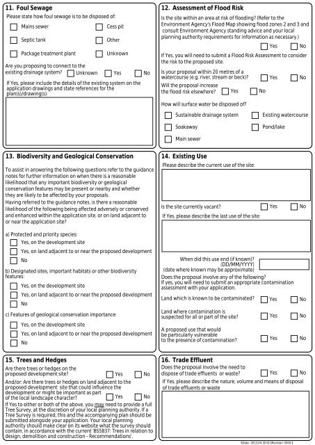
11. Foul SewagePlease state how foul sewage is to be disposed of:Mains sewerSeptic tankPackage treatment plantAre you proposing to connect to theexisting drainage system? UnknownCess pitOtherUnknownYesIf Yes, please include the details of the existing system on theapplication drawings and state references for theplan(s)/drawing(s):No12. Assessment of Flood RiskIs the site within an area at risk of flooding? (Refer to theEnvironment Agency's Flood Map showing flood zones 2 and 3 andconsult Environment Agency standing advice and your localplanning authority requirements for in<strong>form</strong>ation as necessary.)YesIf Yes, you will need to submit a Flood Risk Assessment to considerthe risk to the proposed site.Is your proposal within 20 metres of awatercourse (e.g. river, stream or beck)?Will the proposal increasethe flood risk elsewhere? Yes NoHow will surface water be disposed of?YesNoNoSustainable drainage systemSoakawayExisting watercoursePond/lakeMain sewer13. Biodiversity and Geological ConservationTo assist in answering the following questions refer to the guidancenotes for further in<strong>form</strong>ation on when there is a reasonablelikelihood that any important biodiversity or geologicalconservation features may be present or nearby and whetherthey are likely to be affected by your proposals.Having referred to the guidance notes, is there a reasonablelikelihood of the following being affected adversely or conservedand enhanced within the application site, or on land adjacent toor near the application site?a) Protected and priority species:Yes, on the development siteYes, on land adjacent to or near the proposed developmentNob) Designated sites, important habitats or other biodiversityfeatures:Yes, on the development siteYes, on land adjacent to or near the proposed developmentNoc) Features of geological conservation importance:Yes, on the development siteYes, on land adjacent to or near the proposed developmentNo14. Existing UsePlease describe the current use of the site:Is the site currently vacant? Yes NoIf Yes, please describe the last use of the site:When did this use end (if known)?(DD/MM/YYYY)(date where known may be approximate)Does the proposal involve any of the following?If yes, you will need to submit an appropriate contaminationassessment with your application.Land which is known to be contaminated? Yes NoLand where contamination issuspected for all or part of the site? Yes NoA proposed use that wouldbe particularly vulnerableto the presence of contamination? Yes No15. Trees and HedgesAre there trees or hedges on theproposed development site?Yes NoAnd/or: Are there trees or hedges on land adjacent to theproposed development site that could influence thedevelopment or might be important as partof the local landscape character?Yes NoIf Yes to either or both of the above, you may need to provide a fullTree Survey, at the discretion of your local planning authority. If aTree Survey is required, this and the accompanying plan should besubmitted alongside your application. Your local planningauthority should make clear on its website what the survey shouldcontain, in accordance with the current 'BS5837: Trees in relation todesign, demolition and construction - Recommendations'.16. Trade EffluentDoes the proposal involve the need todispose of trade effluents or waste?Yes NoIf Yes, please describe the nature, volume and means of disposalof trade effluents or waste$Date:: 2013-04-30 #$ $Revision: 5504 $


