Comprehensive Water Management Plan - St. Louis County
Comprehensive Water Management Plan - St. Louis County
Comprehensive Water Management Plan - St. Louis County

You also want an ePaper? Increase the reach of your titles
YUMPU automatically turns print PDFs into web optimized ePapers that Google loves.
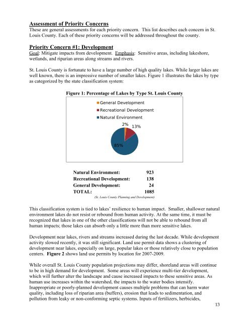
Assessment of Priority ConcernsThese are general assessments for each priority concern. This list describes each concern in <strong>St</strong>.<strong>Louis</strong> <strong>County</strong>. Each of these priority concerns will be addressed throughout the county.Priority Concern #1: DevelopmentGoal: Mitigate impacts from development. Emphasis: Sensitive areas, including lakeshore,wetlands, and riparian areas along streams and rivers.<strong>St</strong>. <strong>Louis</strong> <strong>County</strong> is fortunate to have a large number of high quality lakes. While larger lakes arewell known, there is an impressive number of smaller lakes. Figure 1 illustrates the lakes by typeas categorized by the state classification system:Figure 1: Percentage of Lakes by Type <strong>St</strong>. <strong>Louis</strong> <strong>County</strong>General DevelopmentRecreational DevelopmentNatural Environment2% 13%85%Natural Environment: 923Recreational Development: 138General Development: 24TOTAL: 1085(<strong>St</strong>. <strong>Louis</strong> <strong>County</strong> <strong>Plan</strong>ning and Development)This classification system is tied to lakes’ resilience to human impact. Smaller, shallower naturalenvironment lakes do not resist or rebound from human activity. At the same time, it must berecognized that lakes in one of the other classifications will not be able to rebound from allhuman impacts; those lakes can absorb only a little more than more sensitive lakes.Development near lakes, rivers and streams increased during the last decade. While developmentactivity slowed recently, it was still significant. Land use permit data shows a clustering ofdevelopment near lakes, especially on large, popular lakes or those relatively close to populationcenters. Figure 2 shows land use permits by location for 2007-2009.While overall <strong>St</strong>. <strong>Louis</strong> <strong>County</strong> population projections may differ, shoreland areas will continueto be in high demand for development. Some areas will experience multi-tier development,which will further alter the landscape and cause increased impacts to these sensitive areas. Ashuman use increases within the watershed, the impacts to the water bodies intensify.Inappropriate or poorly-planned development causes multiple problems that can harm waterquality, including loss of riparian area (buffers), erosion that leads to sedimentation, andpollution from leaky or non-conforming septic systems. Inputs of fertilizers, herbicides,13