A View from Space Exhibit Description - OMSI
A View from Space Exhibit Description - OMSI
A View from Space Exhibit Description - OMSI

Create successful ePaper yourself
Turn your PDF publications into a flip-book with our unique Google optimized e-Paper software.
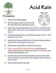
A VIEW FROM SPACEA TRAVELING EXHIBITION(700 Sq. Ft.)EXHIBIT DESCRIPTIONSince the launch of the world’s first artificial satellite Sputnik in 1957, satellites have dramaticallychanged the way we study our planet. A <strong>View</strong> <strong>from</strong> <strong>Space</strong>, a bilingual (Spanish and English)traveling exhibit <strong>from</strong> the Oregon Museum of Science and Industry, gives museum visitors a chanceto see the world <strong>from</strong> a satellite’s perspective. In this highly interactive, hands-on science exhibit,visitors will be able to track a hurricane <strong>from</strong> space, send a satellite spinning into orbit around amodel Earth, study images of our planet captured by NASA’s Earth Observing System, and more.A <strong>View</strong> <strong>from</strong> <strong>Space</strong> is designed to introduce visitors to the latest and greatest of the Earthobserving satellites and give them an appreciation for the value of studying Earth <strong>from</strong> space.Visitors will be challenged to become scientists, study satellite images, and try to answer importantquestions about our dynamic planet.A <strong>View</strong> <strong>from</strong> <strong>Space</strong> includes:SATELLITE ACTIVITY AREAYoung visitors are just beginning to think about Earth, space, and the solar system. The satelliteactivity area encourages families to explore these topics together through creative, open-endedplay. The area features a drawing station with satellite stencils, a free-play activity table with spacethemedtoys, and a reading area. A posting board lets visitors display their artwork and allowseducators to share the latest news <strong>from</strong> NASA’s Earth observing satellites.HOW HIGH ARE THE SATELLITES?How far above us do satellites orbit? Where is the International <strong>Space</strong> Station? When you are in anairplane, are you as high as a satellite? Using an air-powered bar graph, visitors send balls shootingup a large profile of the Earth’s atmosphere, revealing the orbit and flight altitudes of satellites,space stations, weather balloons, airplanes, and more. Visitors can compare and contrast the heightof satellites.SATELLITE ORBITThis exhibit offers a dramatic demonstration of how satellites orbit the Earth and capture images ofthe entire planet. With the turn of a crank, visitors send a satellite spinning around a rotating modelEarth. An ultraviolet light <strong>from</strong> the satellite leaves a phosphorescent trail, painting a clear picture ofthe satellite’s path.SATELLITE PUZZLESTwo large floor puzzles offer a playful activity for families and young visitors. The first puzzle usescolorful cartoons to compare the size of satellites to everyday objects, such as a beach ball or amini-van. The other puzzle gives visitors a peek into the inner workings of NASA’s Aqua satellite.1
SEASONAL CHANGESFrom space, satellites can capture images of the entire globe over long periods of time, revealingnew and often surprising information about our planet. At this station, visitors spin a praxinoscopeand see an entire year of satellite data <strong>from</strong> North America compressed into a few seconds ofanimation. Complex patterns of change are suddenly revealed as visitors watch cycles of drought,snow accumulation, and vegetation growth across the continent.CHANGING OUR PLANETWhat can satellites tell us about the way human population growth and resource use are changingthe Earth’s lands, oceans, and climate? At this exhibit three rotating cubes, featuring modern andhistoric satellite images, illustrate some of the important environmental changes that NASA’ssatellites are tracking <strong>from</strong> space. As visitors turn the cubes, they watch the city of Las Vegasexpand, the forests of Brazil shrink, and the Antarctic ozone hole grow.THE BIG PICTUREThe world looks very different when you are more than 400 miles <strong>from</strong> the surface of the Earth!This flip panel matching game challenges visitors to expand their point of view and try to identifythe Grand Canyon <strong>from</strong> a series of ground photos, aerial photos, and satellite images. Atopographical map of the canyon gives visitors a hands-on appreciation of a satellite’s perspective.WHAT CAN YOU FIND?A large banner display features a wide-view image of North America on one side and a detailed,one-meter resolution image of downtown Manhattan on the other. Visitors are introduced to theimportance of scale and resolution as they compare these images captured by two differentsatellite missions. An accompanying activity encourages visitors to search for details, such as thesmoke <strong>from</strong> a Montana wildfire, which is visible on the image of North America.IMAGE GALLERYThis two-sided banner demonstrates the beauty of our planet viewed <strong>from</strong> space and highlightsseveral of NASA’s important satellite missions. On one side, visitors can study the classic “bluemarble” image of the Earth. On the other side are nine images of the planet, each created usingdata <strong>from</strong> a different satellite sensor, depicting global ocean temperatures, sea surface winds, theAntarctic ozone hole, and more.SATELLITE VISIONBy carefully measuring different wavelengths of light reflected <strong>from</strong> the Earth, many of which areinvisible to the human eye, satellites reveal a whole new level of information about our planet. Atthese specially designed “Pepper’s Ghost illusion” boxes, visitors turn a knob to fade between truecolorand false-color satellite images. Through the activity, visitors learn how a satellite’s sensorsare able to measure sea surface temperature in the Atlantic Ocean and track atmospheric pollutionover Central America.SATELLITES TRACK HURRICANESOn the afternoon of August 13, 2004, one of the most devastating hurricanes in history slammedinto the Florida Coast, causing an estimated 15 billion dollars in damage. This interactive hurricanetrackingmap tells visitors the story of Hurricane Charley and challenges them to predict Charley’slandfall location based on real satellite data. Visitors use a magnetic “puck” to trace the path of thehurricane and discover the important role of satellites in studying these awesome storms.A VIEW FROM SPACE was created and is toured by the Oregon Museum of Science and Industry. The exhibit was made possible with fundsprovided by the National Aeronautics & <strong>Space</strong> Administration (NASA).2