Download Brochure for Cobra GPR - Radarteam Sweden AB
Download Brochure for Cobra GPR - Radarteam Sweden AB
Download Brochure for Cobra GPR - Radarteam Sweden AB

Create successful ePaper yourself
Turn your PDF publications into a flip-book with our unique Google optimized e-Paper software.
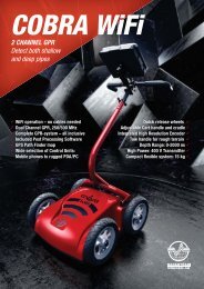
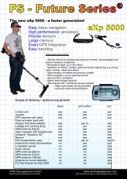
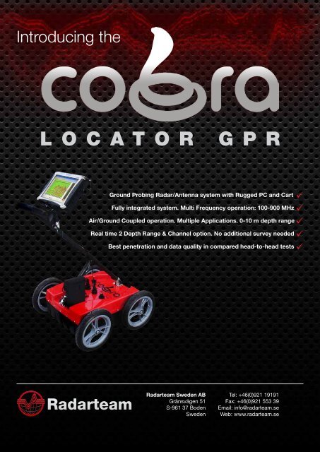
Introducing theL O C A T O R G P RGround Probing Radar/Antenna system with Rugged PC and Cart üFully integrated system. Multi Frequency operation: 100-900 MHz üAir/Ground Coupled operation. Multiple Applications. 0-10 m depth range üReal time 2 Depth Range & Channel option. No additional survey needed üBest penetration and data quality in compared head-to-head tests ü<strong>Radarteam</strong><strong>Radarteam</strong> <strong>Sweden</strong> <strong>AB</strong>Gränsvägen 51S-961 37 Boden<strong>Sweden</strong>Tel: +46(0)921 19191Fax: +46(0)921 553 39Email: info@radarteam.seWeb: www.radarteam.se
<strong>Cobra</strong> Locator <strong>GPR</strong> applicationsJust like X-ray and ultrasound can image the inside of your body,the <strong>Cobra</strong> Locator <strong>GPR</strong> can be used to image the inside ofdifferent materials and structures.Infrastructure & utility mappingInspect internal structures and identify voids under; roads, airports, bridges, tunnels, railways, dams and buildings.Locate plastic, concrete, clay- or metal pipes. Map concrete be<strong>for</strong>e drilling, cutting or coring. Detect obstacles in frontof directional drilling operationsMilitary and securityLocate tunnels, bunkers, hidden weapons and drugs. Find land mines and unexploded ordnance (UXO).Through wall imaging.
Rescue operationsLocate trapped victims under collapsed buildings and landslides.EnvironmentalLocate hazardous waste,UST-location. Delineation ofcontaminant plumes and productspills. Map shallow lakes and rivers.
Archaeology & <strong>for</strong>ensicsPre-excavation mapping of buried structures, foundations,burials and chambers.One of <strong>Radarteam</strong> <strong>Sweden</strong> <strong>AB</strong> most famous projects waswhen we discovered a 20.000 year old woolly mammoth,well preserved in the permafrost ground of Siberia. Theproject is frequently show cased by Discovery Channel,“Raising the Mammoth”.
Best possible data qualitySnow surfaceGround surface3 shallow pipesHigh resolution capacityAirborne snow survey, raw dataFrost levelPipeSand with silty layersBedrockHigh penetration (9 m in silty sand)Large diameter concrete pipes3 Underground Storage Tanks, USTUST - Underground storage tanksRoad culverts at 6 meter depth
Technical specificationsAntenna / <strong>GPR</strong>Antenna typePeak frequencyOperating bandwidthSystem per<strong>for</strong>manceApplied voltageSample rateScan rateSample outputDual shielded antennas with integrated 2 channel Ground Penetrating Radar systemCylindrical Butterfly Dipole (CBD-antenna), resistively loaded. Both air/ground-coupledoperation.250 MHz100 - 900 MHz174 dB100 V100,000 samples/s1-100 scans/s @ 512 samples/scan16 bit digital raw dataControl unit / CUData <strong>for</strong>matData channelsVertical filtersHorizontal filtersGain pointsGain levelsData storageData file sizeRugged, MIL-STD-810F, water- and dust resistant, Panasonic Toughbook CF-19 laptopwith bundled data acquisition, DAQ- software, <strong>for</strong> control, display, processing andstorage of <strong>GPR</strong>-data.Geoscanners Data Format (.gsf)1 or 2 with individual settings <strong>for</strong> depth, filter and gain (2 optional)Low-pass and High-pass FFT (Boxcar 1st order)Stacking, background removal1 - 2 Linear gain-20 to +60 dBRaw or Processed realtime data storage. Auto save or save on command.Limited only by available HDD-space (80 GB <strong>for</strong> Control Unit)Survey cartIntegrated cart with mounting bracket <strong>for</strong> CU. 12” removable non-inflatable wheels withSW-encoder.EnviromentalTemperatureHumidityIngress protection-20°C to 40°C96% non-condensingIP68 (Power, USB, SW-encoder connectors)MechanicalSize (L x W x H)Weight52 x 40 x 19 cm (20 x 16 x 7,5 in)16 kg (36 lbs)OperatingOperating plat<strong>for</strong>msBatteryOperating timeOperating modeGPS positionsOperating depthAirborne operation, high speed air-coupled operation, ground-coupled operationExternal Li Ion: 10,8V (6,6 Ah), 71 Wh6 - 8 hoursTime (1-100 scans/s), Distance (SW-encoder)GPS positions integrated with <strong>GPR</strong>-data <strong>for</strong> every scan in both time- and distance modeShallow - Medium - Deep range (32, 64, 128 ns). 2,5 - 5 - 10 m @ v=0,15 m/ns (e r=4)AccessoriesHardwareSoftwareHelicopter survey kit, High speed road/Railway kit, Rugged terrain kit<strong>GPR</strong>Soft Post processing software <strong>for</strong> <strong>Cobra</strong> Locator Data (.gsf-<strong>for</strong>mat)DAQ-2 channel, 3D-Module
<strong>Radarteam</strong><strong>Radarteam</strong> <strong>Sweden</strong> <strong>AB</strong>Gränsvägen 51S-961 37 Boden<strong>Sweden</strong>Tel: +46(0)921 19191Fax: +46(0)921 553 39Email: info@radarteam.seWeb: www.radarteam.se