Los Angeles Regional Dredged Material Management Plan ...
Los Angeles Regional Dredged Material Management Plan ...
Los Angeles Regional Dredged Material Management Plan ...
- No tags were found...

You also want an ePaper? Increase the reach of your titles
YUMPU automatically turns print PDFs into web optimized ePapers that Google loves.
U.S. Army Corpsof Engineers<strong>Los</strong> <strong>Angeles</strong> DistrictLOS ANGELES REGIONAL DREDGED MATERIAL MANAGEMENT PLANFEASIBILITY STUDYBASELINE CONDITIONS (F3) REPORTU.S. Army Corps of Engineers<strong>Los</strong> <strong>Angeles</strong> District915 Wilshire Boulevard<strong>Los</strong> <strong>Angeles</strong>, California 90017August 2004
Table of Contents3 EXISTING (BASELINE) CONDITIONS............................................................... 373.1 Dredging History and Disposal Practice ................................................... 373.2 <strong>Regional</strong> <strong>Dredged</strong> <strong>Material</strong> Characteristics .............................................. 393.2.1 Santa Monica Bay........................................................................ 413.2.1.1 Sediment Source(s)........................................................... 413.2.1.2 Physical Characteristics .................................................... 413.2.1.3 Chemical & Toxicological Characteristics ......................... 413.2.1.4 Source of Contamination................................................... 413.2.1.5 Biological Community........................................................ 423.2.2 San Pedro Bay – Port of <strong>Los</strong> <strong>Angeles</strong> ......................................... 423.2.2.1 Sediment Source(s)........................................................... 423.2.2.2 Physical Characteristics .................................................... 423.2.2.3 Chemical and Toxicological Characteristics...................... 423.2.2.4 Source of Contamination................................................... 433.2.2.5 Biological Community........................................................ 433.2.3 San Pedro Bay – Port of Long Beach.......................................... 433.2.3.1 Sediment Source(s)........................................................... 433.2.3.2 Physical Characteristics .................................................... 433.2.3.3 Chemical & Toxicological Characteristics ......................... 443.2.3.4 Source of Contamination................................................... 443.2.3.5 Biological Community........................................................ 443.2.4 San Pedro Bay – <strong>Los</strong> <strong>Angeles</strong> River Estuary .............................. 443.2.4.1 Sediment Source(s)........................................................... 443.2.4.2 Physical Characteristics .................................................... 453.2.4.3 Chemical and Toxicological Characteristics...................... 453.2.4.4 Source of Contamination................................................... 453.2.4.5 Biological Community........................................................ 453.2.5 Alamitos Bay................................................................................ 453.2.5.1 Sediment Source(s)........................................................... 463.2.5.2 Physical Characteristics .................................................... 463.2.5.3 Chemical and Toxicological Characteristics...................... 463.2.5.4 Source of Contamination................................................... 463.2.5.5 Biological Community........................................................ 463.3 Biological Resources in the Study Area.................................................... 473.3.1 Habitats ....................................................................................... 473.3.2 Biological Communities ............................................................... 473.3.3 Sensitive and Recreationally Important Species ......................... 483.4 Water Quality ............................................................................................ 493.5 Commercial and Recreational Resources ................................................ 493.5.1 Santa Monica Bay........................................................................ 493.5.1.1 Marina del Rey .................................................................. 493.5.1.2 King Harbor ....................................................................... 503.5.2 San Pedro Bay............................................................................. 513.5.2.1 Ports of <strong>Los</strong> <strong>Angeles</strong> and Long Beach .............................. 513.5.2.2 <strong>Los</strong> <strong>Angeles</strong> River Estuary ................................................ 523.5.2.3 Alamitos Bay ..................................................................... 523.6 Land Use................................................................................................... 533.7 Cultural Resources ................................................................................... 533.8 Economic Analyses................................................................................... 543.8.1 <strong>Los</strong> <strong>Angeles</strong> County..................................................................... 543.8.2 Recreational and Commercial Value of County Harbors ............. 55<strong>Los</strong> <strong>Angeles</strong> <strong>Regional</strong> DMMP FS August 2004Baseline Conditions (F3) Report ii U.S. Army Corps of Engineers, LA District
Table of Contents3.9 Regulatory Approval Processes................................................................ 563.10 Dredging and Disposal Best <strong>Management</strong> Practices................................ 584 FUTURE WITHOUT-PROJECT CONDITIONS .................................................. 594.1 Dredging Needs and Disposal Practice .................................................... 594.2 <strong>Regional</strong> <strong>Dredged</strong> <strong>Material</strong> Characteristics .............................................. 614.2.1 Santa Monica Bay – Marina del Rey ........................................... 644.2.1.1 Source of <strong>Material</strong> ............................................................. 654.2.1.2 Physical Characteristics .................................................... 664.2.1.3 Chemical and Toxicological Characteristics...................... 664.2.1.4 Source of Contamination................................................... 664.2.1.5 Biological Community........................................................ 664.2.2 San Pedro Bay – Port of <strong>Los</strong> <strong>Angeles</strong> ......................................... 664.2.2.1 Source of <strong>Material</strong> ............................................................. 684.2.2.2 Physical Characteristics .................................................... 684.2.2.3 Chemical and Toxicological Characteristics...................... 684.2.2.4 Source of Contamination................................................... 684.2.2.5 Biological Community........................................................ 694.2.3 San Pedro Bay – Port of Long Beach.......................................... 694.2.3.1 Source of <strong>Material</strong> ............................................................. 704.2.3.2 Physical Characteristics .................................................... 704.2.3.3 Chemical and Toxicological Characteristics...................... 704.2.3.4 Source of Contamination................................................... 704.2.3.5 Biological Community........................................................ 704.2.4 San Pedro Bay – <strong>Los</strong> <strong>Angeles</strong> River Estuary .............................. 714.2.4.1 Source of <strong>Material</strong> ............................................................. 714.2.4.2 Physical Characteristics .................................................... 714.2.4.3 Chemical and Toxicological Characteristics...................... 714.2.4.4 Source of Contamination................................................... 714.2.4.5 Biological Community........................................................ 724.2.5 San Pedro Bay – Alamitos Bay.................................................... 724.2.5.1 Source of <strong>Material</strong> ............................................................. 724.2.5.2 Physical Characteristics .................................................... 724.2.5.3 Chemical and Toxicological Characteristics...................... 724.2.5.4 Source of Contamination................................................... 724.2.5.5 Biological Community........................................................ 724.3 Biological Resources in the Area .............................................................. 734.4 Water Quality ............................................................................................ 734.5 Recreational Resources............................................................................ 734.5.1 Santa Monica Bay........................................................................ 734.5.1.1 Marina del Rey .................................................................. 734.5.1.2 King Harbor ....................................................................... 734.5.2 San Pedro Bay............................................................................. 744.5.2.1 Port of <strong>Los</strong> <strong>Angeles</strong> and Port of Long Beach .................... 744.5.2.2 <strong>Los</strong> <strong>Angeles</strong> River Estuary ................................................ 744.5.2.3 Alamitos Bay ..................................................................... 744.6 Land Use................................................................................................... 744.7 Cultural Resources ................................................................................... 744.8 Economic Analyses................................................................................... 754.9 Regulatory Approval Process ................................................................... 804.10 Dredging and Disposal Best <strong>Management</strong> Practices................................ 81<strong>Los</strong> <strong>Angeles</strong> <strong>Regional</strong> DMMP FS August 2004Baseline Conditions (F3) Report iii U.S. Army Corps of Engineers, LA District
Table of Contents5 FORMULATION OF ALTERNATIVES ................................................................ 885.1 Statement of Problem ............................................................................... 885.2 National Objective..................................................................................... 885.3 Study <strong>Plan</strong>ning Objectives........................................................................ 895.4 <strong>Plan</strong>ning Opportunities & Constraints ....................................................... 895.5 Evaluation Criteria..................................................................................... 915.5.1 Completeness, Effectiveness, and Efficiency.............................. 925.5.1.1 Engineering ....................................................................... 925.5.1.2 Economics......................................................................... 925.5.2 Acceptability................................................................................. 925.5.2.1 Environmental ................................................................... 925.5.2.2 Public Views ...................................................................... 925.6 Preliminary Alternatives Considered......................................................... 925.6.1 No Action ..................................................................................... 945.6.2 Source Control............................................................................. 945.6.3 Temporary Storage...................................................................... 955.6.4 Treatment .................................................................................... 965.6.4.1 Cement Stabilization ......................................................... 965.6.4.2 Sediment Washing ............................................................ 985.6.4.3 Sediment Blending .......................................................... 1005.6.4.4 Sediment Separation....................................................... 1015.6.4.5 Thermal Desorption......................................................... 1015.6.4.6 Treatment, Storage and Reprocessing (TSR) Site.......... 1025.6.5 Disposal..................................................................................... 1025.6.5.1 Ocean Disposal ............................................................... 1035.6.5.2 Aquatic Capping/Confined Aquatic Disposal................... 1035.6.5.3 Confined Disposal Facility ............................................... 1045.6.5.4 Geo-Textile Encapsulation .............................................. 1045.6.5.5 Upland/Landfill Disposal.................................................. 1055.7 Summary of Preliminary Alternatives Considered .................................. 1055.8 Beneficial Uses for Treated or Clean <strong>Material</strong> ........................................ 1065.8.1 Beach Nourishment ................................................................... 1065.8.2 Shallow Water Habitat Creation................................................. 1065.8.3 Construction Fill......................................................................... 1065.8.4 Landfill Daily Cover.................................................................... 1075.8.5 Reclamation Fill ......................................................................... 1085.8.6 Oil Well Injections ...................................................................... 1095.8.7 Capping <strong>Material</strong> for <strong>Regional</strong> Capping Projects....................... 1096 SUMMARY AND RECOMMENDATIONS......................................................... 1106.1 Summary................................................................................................. 1106.2 Recommendations.................................................................................. 1106.2.1 Multi-User Confined Aquatic Disposal Site at the North Energy .....Island Borrow Pit........................................................................ 1116.2.2 <strong>Regional</strong> Treatment, Storage, and Reprocessing Facility ......... 1136.2.3 City of Long Beach CDF............................................................ 1137 REFERENCES.................................................................................................. 115<strong>Los</strong> <strong>Angeles</strong> <strong>Regional</strong> DMMP FS August 2004Baseline Conditions (F3) Report iv U.S. Army Corps of Engineers, LA District
Table of ContentsList of TablesTable 1-1Table 3-1Table 3-2Table 3-3Table 3-4Table 4-1Table 4-2Table 4-3Table 4-4Table 4-5Table 4-6Table 4-7CSTF Membership and ParticipationDredging Volumes SummaryDisposal Method Volumes SummarySummary of 303(d) listings for the Dredge <strong>Management</strong> Areas in <strong>Los</strong> <strong>Angeles</strong>CountyLand Use by Watershed20-Year Projection for Sediment Generation in the <strong>Los</strong> <strong>Angeles</strong> RegionDraft TMDL Development ScheduleEstimated Future Maintenance Dredging Cost for Marina del ReyEstimated Future Maintenance Dredging Cost for Port of <strong>Los</strong> <strong>Angeles</strong>Estimated Future Maintenance Dredging Cost for Port of Long BeachEstimated Future Maintenance Dredging Cost for <strong>Los</strong> <strong>Angeles</strong> River EstuaryBMP Toolbox for Dredging Contaminated SedimentsList of FiguresFigure 2-1Figure 2-2Figure 2-3Figure 2-4Figure 2-5Figure 2-6Figure 2-7Figure 2-8Figure 2-9Figure 2-10Figure 2-11Figure 3-1Figure 4-1Figure 5-1Figure 6-1Figure 6-2<strong>Los</strong> <strong>Angeles</strong> <strong>Regional</strong> DMMP Feasibility Study AreaMarina del Rey and Ballona CreekRedondo Beach – King HarborSan Pedro Bay – Port of <strong>Los</strong> <strong>Angeles</strong>, Port of Long Beach, and Alamitos Bay<strong>Los</strong> <strong>Angeles</strong> River EstuaryStudy Area Bathymetry SettingMarina del Rey/Ballona Creek Bathymetry DataKing Harbor Bathymetry DataPort of <strong>Los</strong> <strong>Angeles</strong> Navigation Channel Bathymetry DataPort of Long Beach Navigation Channel Bathymetry DataExisting StructuresMajor Watersheds in the Study AreaGuide for BMP Selection for Contaminated Sediments<strong>Los</strong> <strong>Angeles</strong> <strong>Regional</strong> DMMP Feasibility Study Preliminary AlternativesLocation of the NEIBP Pilot Study CAD SiteCity of Long Beach Proposed CDF Site<strong>Los</strong> <strong>Angeles</strong> <strong>Regional</strong> DMMP FS August 2004Baseline Conditions (F3) Report v U.S. Army Corps of Engineers, LA District
Acronyms and AbbreviationsARSSSB/CB.P.Basin <strong>Plan</strong>BLSBMPsBPTCPCADCCCCDFCDFGCEQAcmCWACOBRACorpsCountyCSTFCSWHCZMADDTDMMPEIREISENSOEPAER-LER-MERDCESAFSFWCAFWSFYHAVEHEPITMIWRkg/cm 2kmhLACDPWLAEDCAnchorage Road Soil Storage Sitebenefit-costBefore PresentWater Quality Control <strong>Plan</strong>U.S. Bureau of Labor StatisticsBest <strong>Management</strong> PracticesBay Protection and Toxic Cleanup ProgramConfined aquatic disposalCalifornia Coastal Commissionconfined disposal facilityCalifornia Department of Fish and GameCalifornia Environmental Quality ActcentimetersClean Water ActCalifornia Outdoor Motor Racing AssociationU.S. Army Corps of Engineers<strong>Los</strong> <strong>Angeles</strong> CountyContaminated Sediments Task ForceCabrillo Shallow Water HabitatCoastal Zone <strong>Management</strong> ActDichlorodiphenyltrichloroethane<strong>Dredged</strong> <strong>Material</strong> <strong>Management</strong> <strong>Plan</strong>Environmental Impact ReportEnvironmental Impact StatementEl Nino Southern OscillationU.S. Environmental Protection Agencyeffects range-loweffects range-medianEngineering Research Development CenterEndangered Species ActFeasibility StudyFish and Wildlife Coordination ActU.S. Department of Interior Fish and Wildlife Servicefiscal yearhot air vapor extractionHarbors Environmental ProjectsInland Testing ManualInstitute for Water Resourceskilograms per square centimeterkilometers per hour<strong>Los</strong> <strong>Angeles</strong> County Department of Public Works<strong>Los</strong> <strong>Angeles</strong> County Economic Development Corporation<strong>Los</strong> <strong>Angeles</strong> <strong>Regional</strong> DMMP FS August 2004Baseline Conditions (F3) Report vi U.S. Army Corps of Engineers, LA District
Acronyms and AbbreviationsLARELARWQCBm 3m 3 /yrMCLMECµg/kgmg/kgmg/LmgC/hr/m 2MHWMHHWMLWMLLWMOUMPRSAmpsMSFCMAMSLNAVDNCDCNEDNEIBPNEPANMFSNOAANPDESNPSNTDENWSP&GPAHPCBsPEPETPOLBPOLAPMPPP<strong>Los</strong> <strong>Angeles</strong> River Estuary<strong>Los</strong> <strong>Angeles</strong> <strong>Regional</strong> Water Quality Control Boardcubic meterscubic meters per yearMaximum Contaminant LevelsMEC Analytical Systemsmicrograms per kilogrammilligrams per kilogrammilligrams per Litermilligrams of carbon per hour per square metermean high watermean higher high watermean low watermean lower low waterMemorandum of UnderstandingMarine Protection, Research, and Sanctuaries Actmeters per secondMagnuson-Stevens Fishery Conservation and <strong>Management</strong> ActMean Sea LevelNorth American Vertical DatumNational Climatic Data CenterNational Economic DevelopmentNorth Energy Island Borrow PitNational Environmental Policy ActNational Marine Fisheries ServiceNational Oceanic and Atmospheric AdministrationNational Pollutant Discharge Elimination SystemNon-Point SourceNational Tidal Datum EpochNational Weather ServicePrinciples and GuidelinesPolycyclic Aromatic HydrocarbonPolychlorinated BiphenylsPolyethylenePolyesterPort of Long BeachPort of <strong>Los</strong> <strong>Angeles</strong>Project <strong>Management</strong> <strong>Plan</strong>Polypropylene<strong>Los</strong> <strong>Angeles</strong> <strong>Regional</strong> DMMP FS August 2004Baseline Conditions (F3) Report vii U.S. Army Corps of Engineers, LA District
Acronyms and AbbreviationsPSDDA SLPSTREC-1RegionRHARSMRTKSAASB673SCCWRPsecSMBRCSMBRPSMMPSPLPSTLCSUSMPSVOASWHSWRCBTDSTEUsTMDLsTOCTSRUSACEUTMWDRWMAWMIWETWRCCPuget Sound <strong>Dredged</strong> Disposal Analysis screen levelsPacific Standard TimeRecreational activities involving body contact with water<strong>Los</strong> <strong>Angeles</strong> RegionRivers and Harbors Act<strong>Regional</strong> Sediment <strong>Management</strong>Real Time KinematicStreambed Alteration AgreementSenator Karnette BillSouthern California Coastal Water Research ProjectsecondsSanta Monica Bay Restoration CommissionSanta Monica Bay Restoration ProjectSite Maintenance and Monitoring ProgramSynthetic Precipitation Leaching ProcedureSoluble Threshold Limit ConcentrationsStandard Urban Storm Water Mitigation <strong>Plan</strong>semi-volatile organic concentrationsShallow water habitatState Water Resources Control Boardtotal dissolved solids20-foot equivalent unitsTotal Maximum Daily Loadstotal organic carbontreatment, storage, and reprocessingU.S. Army Corps of Engineers, <strong>Los</strong> <strong>Angeles</strong> DistrictUpland Testing ManualWaste Discharge RequirementWater <strong>Management</strong> AreaWatershed <strong>Management</strong> InitiativeWaste Extraction TestWestern <strong>Regional</strong> Climate Center<strong>Los</strong> <strong>Angeles</strong> <strong>Regional</strong> DMMP FS August 2004Baseline Conditions (F3) Report viii U.S. Army Corps of Engineers, LA District
Introduction1 INTRODUCTION1.1 Study AuthorityPreparation of the <strong>Los</strong> <strong>Angeles</strong> <strong>Regional</strong> <strong>Dredged</strong> <strong>Material</strong> <strong>Management</strong> <strong>Plan</strong> (DMMP)Feasibility Study (FS) is authorized under the Water Resources Development Act of 1986 andthe Energy and Water Development Appropriations Act for 2000, Public Law 106-60, 29September 1999, which reads as follows:The Committee recommendation includes funds for the Corps of Engineers to conduct areconnaissance study of a regional dredged material management plan for contaminatedsediments in <strong>Los</strong> <strong>Angeles</strong>, California.1.2 Local SponsorshipNon-federal sponsors for the DMMP FS include the County of <strong>Los</strong> <strong>Angeles</strong> (County), City ofLong Beach, and the Port of <strong>Los</strong> <strong>Angeles</strong> (POLA).1.3 Study PurposeThe U.S. Army Corps of Engineers, <strong>Los</strong> <strong>Angeles</strong> District (USACE) is responsible for maintainingsafe navigation of the Marina del Rey harbor entrance and the <strong>Los</strong> <strong>Angeles</strong> River Estuary(LARE) through regular maintenance dredging. Portions of the material that need to be dredgedat the two locations are contaminated, hence, not suitable for open ocean disposal or beachnourishment. Dredging at these two sites is hampered by a lack of readily available disposaloptions for the contaminated dredged material. Counties and cities within the <strong>Los</strong> <strong>Angeles</strong>Region (Region) also face the same lack of readily available disposal options to fulfill theirdredging needs for harbor and marina maintenance.To solve this problem, the USACE initiated a Reconnaissance Study on March 17, 2000 todetermine if there was a federal interest in participating in a detailed Feasibility Study to developa <strong>Regional</strong> DMMP and multi-user disposal alternatives. As a result of the ReconnaissanceStudy, USACE published the <strong>Los</strong> <strong>Angeles</strong> <strong>Regional</strong> DMMP FS Project <strong>Management</strong> <strong>Plan</strong>(PMP) in August of 2001, identifying federal interest for conducting this Feasibility (F3) Study.The purpose of a standard DMMP is to ensure that maintenance dredging activities areperformed in an environmentally acceptable manner, use sound engineering techniques, areeconomically warranted, and sufficient confined disposal facilities are available for at least thenext 20 years. A DMMP is usually developed for an individual harbor; however the mainobjective of this FS is to develop a <strong>Regional</strong> DMMP for all harbors within the <strong>Los</strong> <strong>Angeles</strong>Region that will define a long-term strategy for the management of dredged sediments.Emphasis will be on determining a solution to the management and disposal of contaminatedsediments. It is expected that the resultant DMMP will satisfy the requirement for a DMMP forMarina del Rey, Ports of <strong>Los</strong> <strong>Angeles</strong> and Long Beach and the City of Long Beach. The<strong>Los</strong> <strong>Angeles</strong> <strong>Regional</strong> DMMP FS August 2004Baseline Conditions (F3) Report 1 U.S. Army Corps of Engineers, LA District
Introductionprimary objective of this DMMP FS is to determine the feasibility and economic justification forimplementing a DMMP on a regional basis to achieve the long-term management of dredgedmaterial in the Region. The detailed objectives of the FS have been defined in the 905(b)Reconnaissance Report (USACE 2000b). As part of the FS process, the primary purpose of thepresent study is to define the baseline conditions in the Region within the context of dredgedmaterial management under the existing and future without project conditions, identifymanagement problems, formulate plan alternatives to address the problems based on nationaland planning objectives, and provide a preliminary evaluation of the alternatives. The purposeof this last step is to select Alternative <strong>Plan</strong>s to be carried forward for detailed evaluation in theFeasibility (F4) Evaluation. At that point, additional technical information for each alternative willbe presented to assist in completing the detailed evaluation.1.4 Study ScopeThe scope of this report includes a survey and review of prior studies by the USACE and othersto describe the physical, chemical, and biological conditions of the Study Area; an evaluation ofregional dredging and disposal needs; and a characterization of physical and chemicalproperties of typical regional dredged materials. In addition, this study formulates alternativesfor managing dredged material for the <strong>Los</strong> <strong>Angeles</strong> area, performs a preliminary evaluation ofthe alternatives, and recommends alternatives for further evaluation.The DMMP FS focuses on the primary dredging sites within the Region including Marina delRey and King Harbor in Santa Monica Bay; and <strong>Los</strong> <strong>Angeles</strong> and Long Beach Harbors, theLARE, and Alamitos Bay in San Pedro Bay. The study uses the results from the assessment ofthese primary dredging sites as the basis for the formulation and evaluation of managementalternatives for the Region.1.5 Study ProcessThe present study constitutes the F3 phase of the FS. This study was preceded by areconnaissance study that identified federal interest and determined the need to proceed withthis detailed, cost-shared FS. The final product of this DMMP FS will be a regionalmanagement plan that identifies the combination of recommended actions to be undertaken byvarious partners and stakeholders in order to achieve the objectives of the study. The F3 studyprovides a description and analysis of the existing and future without-project conditions andproposed alternatives that will form the basis for this plan.The F3 phase includes a preliminary screening of alternatives to determine the feasibility as partof the recommended plan and consistency with National Economic Development (NED) criteria.The plan alternatives that have the greatest contribution to NED, and are agreed upon by thelocal sponsor, will be recommended for more detailed evaluation and selection in thesubsequent F4 and F5 studies. In addition, a draft Environmental Impact Statement/Environmental Impact Report (EIS/EIR) will be prepared to address potential environmental<strong>Los</strong> <strong>Angeles</strong> <strong>Regional</strong> DMMP FS August 2004Baseline Conditions (F3) Report 2 U.S. Army Corps of Engineers, LA District
Introductionimpacts of the proposed alternatives to satisfy the environmental review requirements of boththe National Environmental Policy Act (NEPA) and California Environmental Quality Act(CEQA).The F5 report and draft EIS/EIR will be presented to the public for review. Upon addressingpublic comments received during the public review period, the Assistant Secretary of the Armyfor Civil Works (ASA/CW) will sign the Record of Decision, and the FS report will be finalized,which concludes the USACE FS process. At that point, program implementation can occur.This <strong>Los</strong> <strong>Angeles</strong> DMMP FS is different from a typical USACE FS, which normally involves theselection of a single best alternative from a selection of several feasible alternatives, all capableof meeting the defined objective. This study is developed to formulate a strategy for themanagement of dredged material for the entire Region. Since each dredging project is uniqueand has its own objective that needs to be met, the best alternative for each dredging projectmay be very different. In addition, some of the management measures presented may beimplementable by organizations other than the USACE.Because of the unique nature of this study, the Baseline Condition (F3) report presented here isalso slightly different from a typical USACE F3 study report. This uniqueness is reflected in thepreliminary evaluation of alternatives and the recommendations for alternatives to be movedforward for further detailed evaluation in the F4 study. In addition to recommending “potentially”implementable projects for further evaluation in the F4 study, the F3 study provides the basis forthe development of a regional dredged material management program. Details of theevaluation processes and recommendation for the F4 study are provided in Sections 5 and 6.<strong>Management</strong> recommendations will be formulated to support the goals and objectives of the <strong>Los</strong><strong>Angeles</strong> <strong>Regional</strong> Contaminated Sediment Task Force, as well as the USACE and its sponsors.1.6 Public Involvement and CoordinationPublic involvement and coordination is used to ensure that the USACE planning process isresponsive to the needs and concerns of the public, and to involve all interested parties in theplanning decision-making process. Its objectives are: (1) to provide information about USACEactivities and proposed actions to the public; (2) make public desires, needs and concernsavailable to the decision-makers; (3) provide for adequate interaction with the public beforedecisions are made; and (4) to adequately account for the views of the public in makingdecisions. However, these purposes and objectives must be achieved within a frameworkwhere the USACE cannot relinquish its legislated responsibilities for decision-making.Public involvement and coordination actions are not only used to inform the public, but also toactively seek public responses in regard to needs, values, ideas for solutions, and reactions toproposed solutions. For the DMMP FS, public involvement and coordination were utilized as atwo-way communications process to provide people from diverse backgrounds and interestswith multiple opportunities to ask questions and offer suggestions. An initial public meeting was<strong>Los</strong> <strong>Angeles</strong> <strong>Regional</strong> DMMP FS August 2004Baseline Conditions (F3) Report 3 U.S. Army Corps of Engineers, LA District
Introductionconducted to seek input prior to the initiation of the study, and additional meetings are plannedas alternatives are evaluated. Public involvement efforts and coordination also include theconsultation with other federal, state and local agencies listed in Section 1.6.1. In addition, theDMMP study team had worked closely with the Contaminated Sediments Task Force (CSTF)throughout the study process. Details about the CSTF activities are provided in Section 1.6.2.1.6.1 Consulting AgenciesCoordination with state and federal consulting agencies regarding the DMMP is a critical step incompleting the FS to ensure that the interests and regulations governing each entity are fulfilledwith the final product. To date, coordination has occurred with the following agencies:• U.S. Fish & Wildlife Service (FWS)• California State Department of Fish & Game (CDFG)• U.S. Environmental Protection Agency (EPA), Region 9• <strong>Los</strong> <strong>Angeles</strong> <strong>Regional</strong> Water Quality Control Board (LARWQCB)• California Coastal Commission (CCC)• National Oceanic Atmospheric Association (NOAA), Fisheries Group1.6.2 Contaminated Sediments Task ForceIn response to a growing problem associated with dredging and disposal of contaminatedsediments in the Region, Governor Wilson signed into law Senate Bill SB 673 authored bySenator Betty Karnette of Long Beach on October 12, 1997. This new legislation required theCCC and the LARWQCB to establish a multi-agency CSTF to address issues related todredging and disposing of contaminated sediments. It also required the CCC and theLARWQCB to actively participate in a Task Force and assist in the preparation of a long-termmanagement strategy for dredging and disposal of contaminated sediments in the Region. Thestrategy would consider aquatic and upland disposal alternatives, treatment, beneficial reuse,and other management techniques. Additionally, the strategy would include a componentfocused on the reduction of contaminants at their source.SB 673 was signed into law as Chapter 897 of the Statutes of 1997. Section 13396.9 wasadded to the Water Code to incorporate the conditions of Senate Bill 673, the provisions ofwhich are summarized below.The Karnette Bill (SB 673) added a section to the Water Code that required the LARWQCB andthe CCC, on or before January 1, 2003 1 , to:• Develop a long-term management plan for the dredging and disposal of contaminatedsediments found in coastal waters adjacent to the County;• Establish and participate in a multi-agency <strong>Los</strong> <strong>Angeles</strong> Basin CSTF;1A two year extension was subsequently provided, extending the due date for completion of the CSTF strategy to January 1, 2005.<strong>Los</strong> <strong>Angeles</strong> <strong>Regional</strong> DMMP FS August 2004Baseline Conditions (F3) Report 4 U.S. Army Corps of Engineers, LA District
Introduction• Seek to enter into an agreement with the EPA and USACE to participate in the <strong>Plan</strong>’sdevelopment;• Report to the Legislature on or before January 1, 1999, regarding the status of thatagreement; and• Conduct annual public workshops to review the status of plan development and topromote public participation.In 1999, a cooperative agreement was established through a Memorandum of Understanding(MOU) to officially form the CSTF. When SB 673 was signed into law, a Task Force already inexistence to address the Marina del Rey dredging issues was dissolved and reconvened as apart of the CSTF. The original MOU was amended in 2000 to add additional members andagencies then proceeded to sign both the original agreement and the amendment incorporatingthe provisions of SB 673. Table 1-1 presents a list of the participants in the CSTF.Table 1-1CSTF Membership and ParticipationAgency/OrganizationCSTF OversightResponsibilitiesMeetingParticipantMOUSignatoryCalifornia Coastal Commission √ √ √<strong>Los</strong> <strong>Angeles</strong> <strong>Regional</strong> Water Quality Control Board √ √ √California Department of Fish and GameCity of Long Beach √ √County of <strong>Los</strong> <strong>Angeles</strong> Beaches and Harbors √ √Heal the BayPort of Long Beach √ √Port of <strong>Los</strong> <strong>Angeles</strong> √ √Southern California Coastal Water Research ProjectU.S. Army Corps of Engineers √ √U.S. Environmental Protection Agency √ √U.S. Fish and Wildlife Service√√√√Organizationally, the CSTF consists of an Executive Committee, a <strong>Management</strong> Committee,five Strategy Development Subcommittees, a Technical Advisory Subcommittee, and an InterimDisposal Advisory Subcommittee.The Executive Committee consists of the head of the four regulatory agencies responsible formanaging dredging activities (USACE, EPA, LARWQCB, and the CCC) and is the final level ofapproval for the resulting Strategy Document. The Executive Committee meets on a semiannualbasis to assess the progress of the CSTF Technical and <strong>Management</strong> Committees.The <strong>Management</strong> Committee is the main evaluation and decision making body for the CSTFand conducts meetings every month, which are open to the public. Under the direction of the<strong>Management</strong> Committee are five subcommittees charged with identifying and resolvingtechnical issues related to the development of the CSTF <strong>Management</strong> Strategy. The five<strong>Los</strong> <strong>Angeles</strong> <strong>Regional</strong> DMMP FS August 2004Baseline Conditions (F3) Report 5 U.S. Army Corps of Engineers, LA District
Introductionsubcommittees include the Upland Disposal and Beneficial Reuse Subcommittee; AquaticDisposal and Dredge Operations Subcommittee; Watershed <strong>Management</strong> and SourceReduction Subcommittee; Implementation Subcommittee; and Sediment Screening ThresholdSubcommittee. These groups are charged with preparing specific technical components of theStrategy. An Interim Advisory Subcommittee (which changed its name simply to AdvisoryCommittee in 2001) meets as needed when specific dredging and disposal projects areproposed prior to completion of the Strategy.The last specific objective for the <strong>Los</strong> <strong>Angeles</strong> DMMP is to “recommend a regional dredgedmaterial management plan that is consistent with the <strong>Los</strong> <strong>Angeles</strong> Region CSTF Long-Term<strong>Management</strong> Strategy.” To fulfill this objective, members of the <strong>Plan</strong>ning, Regulatory, andOperations Divisions of the USACE are actively participating in the development of the CSTFreport by sponsoring and managing several pilot field and laboratory studies to evaluatesediment management options identified as data needs during the Strategy Report developmentprocess. USACE staff is also actively involved in the data interpretation process occurring atthe monthly CSTF meetings and leads the Subcommittee on Aquatic Disposal and DredgeOperations. It is anticipated that the CSTF <strong>Management</strong> Strategy and the DMMP will containshared data and offer similar recommendations related to the management of contaminatedsediments.1.6.3 Public MeetingsThere are a variety of meetings that must be effectively utilized in the successful achievement ofpublic involvement/coordination objectives. The most important and visible meetings are theformal public meetings, which are scheduled by directive at the initiation of the feasibility phasestudy, and near the end of the study as part of the public review of the draft feasibility report andthe study findings. Public comment and input are vital to finalizing the feasibility report andcompleting the study. These meetings include public meetings, open meetings with interestgroups, workshops, and any opportunities to distribute information of the study and progress togenerate public input.Prior to initiation of this F3 Baseline Evaluation document, a public scoping meeting was held onFebruary 26, 2003 at the Cesar Chavez Community Center in Long Beach, California. Thepurpose of the meeting was to gather public input on the scope of the project and to outline aschedule for future activities and public involvement. In addition to the formal public meeting,project updates are provided at the monthly meetings of the DMMP <strong>Management</strong>Subcommittee, which are also open to the public.1.7 Prior Studies, Reports, and Existing Federal Projects1.7.1 Prior Studies by USACEThe USACE has extensively studied the <strong>Los</strong> <strong>Angeles</strong> Region. A partial list of major studiessorted by geographic location within the Study Area is presented below.<strong>Los</strong> <strong>Angeles</strong> <strong>Regional</strong> DMMP FS August 2004Baseline Conditions (F3) Report 6 U.S. Army Corps of Engineers, LA District
Introduction1.7.1.1 Santa Monica Bay GeneralSanta Monica Breakwater, <strong>Los</strong> <strong>Angeles</strong> County, CA, Reconnaissance Report. U.S. Army Corpsof Engineers, <strong>Los</strong> <strong>Angeles</strong> District. 1989.Sediment Sources and Sinks in Santa Monica Bay between Point Dume and Marina del Rey.U.S. Army Corps of Engineers, <strong>Los</strong> <strong>Angeles</strong> District. 1992.Feasibility Study for a Capped <strong>Dredged</strong> <strong>Material</strong> Disposal Site in Santa Monica Bay. U.S. ArmyCorps of Engineers, <strong>Los</strong> <strong>Angeles</strong> District. 1993.1.7.1.2 Marina del Rey and Ballona CreekMarina del Rey and Ballona Creek, California, Final Reconnaissance Report. U.S. Army Corpsof Engineers, <strong>Los</strong> <strong>Angeles</strong> District. 1995.Marina del Rey Upland Disposal Alternative for Contaminated Sediments Final Report. U.S.Army Corps of Engineers, <strong>Los</strong> <strong>Angeles</strong> District. 1997.Marina del Rey and Ballona Creek Feasibility Study, <strong>Dredged</strong> <strong>Material</strong> <strong>Management</strong> <strong>Plan</strong>,Baseline Conditions (F3) Report. U.S. Army Corps of Engineers, <strong>Los</strong> <strong>Angeles</strong> District. 1998.Marina del Rey Shoaling and Disposal Feasibility Study, Draft Final Report. U.S. Army Corps ofEngineers, <strong>Los</strong> <strong>Angeles</strong> District. 1998.Marina del Rey and Ballona Creek Feasibility Study <strong>Dredged</strong> <strong>Material</strong> <strong>Management</strong> <strong>Plan</strong>Alternatives Analysis and Report Final Draft Submittal Engineering Alternatives Analysis andReport. U.S. Army Corps of Engineers, <strong>Los</strong> <strong>Angeles</strong> District. Prepared by Moffatt & NicholEngineers. 1999.Marina del Rey and Ballona Creek Feasibility Study, Sediment Transport Analysis and Report.U.S. Army Corps of Engineers, <strong>Los</strong> <strong>Angeles</strong> District. 1999.Sediment Sampling Results, Ballona Creek Sediment Contaminant Source Study. U.S. ArmyCorps of Engineers, <strong>Los</strong> <strong>Angeles</strong> District. 1999.Marina del Rey and Ballona Creek Feasibility Study, <strong>Dredged</strong> <strong>Material</strong> <strong>Management</strong> <strong>Plan</strong>Alternative Analysis (F4) Report. U.S. Army Corps of Engineers, <strong>Los</strong> <strong>Angeles</strong> District andCounty of <strong>Los</strong> <strong>Angeles</strong>. 2000.Marina del Rey and Ballona Creek Watershed, California, Economic Feasibility Report. U.S.Army Corps of Engineers, <strong>Los</strong> <strong>Angeles</strong> District. 2000.<strong>Los</strong> <strong>Angeles</strong> <strong>Regional</strong> DMMP FS August 2004Baseline Conditions (F3) Report 7 U.S. Army Corps of Engineers, LA District
IntroductionBallona Creek Sediment Study Phase I Report. U.S. Army Corps of Engineers, <strong>Los</strong> <strong>Angeles</strong>District. Prepared by CH2M Hill. 2001.Marina del Rey and Ballona Creek Feasibility Study, Ballona Creek Sediment Basin StudyHydrology and Hydraulics Appendix (Draft). U.S. Army Corps of Engineers, <strong>Los</strong> <strong>Angeles</strong>District. 2001.Lower Ballona Creek Restoration <strong>Los</strong> <strong>Angeles</strong> County, California 905(b) ReconnaissanceReport. U.S. Army Corps of Engineers, <strong>Los</strong> <strong>Angeles</strong> District. 2002.Preliminary Draft EIR/EIS for the Ballona Creek Sediment Control <strong>Management</strong> <strong>Plan</strong>. U.S.Army Corps of Engineers, <strong>Los</strong> <strong>Angeles</strong> District. Prepared by Chambers Group. 2002.Draft EIR/EIS for the Balllona Creek Sediment Control <strong>Management</strong> <strong>Plan</strong>. U.S. Army Corps ofEngineers, <strong>Los</strong> <strong>Angeles</strong> District. 2003.Marina del Rey and Ballona Creek Feasibility Study, Sediment Control <strong>Management</strong> <strong>Plan</strong>, FinalDraft Feasibility (F4) Report. U.S. Army Corps of Engineers, <strong>Los</strong> <strong>Angeles</strong> District. 2003.1.7.1.3 King HarborStorm Damage Reduction Feasibility Report – Technical Report: Redondo Beach – King HarborArea, CA. U.S. Army Corps of Engineers, <strong>Los</strong> <strong>Angeles</strong> District. 1988.King Harbor, Redondo Beach, California, Breakwater Stability Study: Hydraulic ModelInvestigation. CERC-90-7. U.S. Army Engineer Waterways Experiment Station. Prepared forthe U.S. Army Corps of Engineers, <strong>Los</strong> <strong>Angeles</strong> District. 1990.Redondo Beach King Harbor, California, Development of Design Data for HarborImprovements: Coastal Model Investigation. CERC-90-6. U.S. Army Engineer WaterwaysExperiment Station. Prepared for the City of Redondo Beach. 1990.Redondo Beach King Harbor, California, Design for Wave Protection: Coastal ModelInvestigation. CERC-90-4. U.S. Army Engineer Waterways Experiment Station. Prepared forthe U.S. Army Corps of Engineers, <strong>Los</strong> <strong>Angeles</strong> District. 1990.1.7.1.4 San Pedro Bay GeneralNumerical Analysis of Harbor Resonance Response in East Channel, <strong>Los</strong> <strong>Angeles</strong>: FinalReport. HL-81-3. Hydraulics Laboratory, U.S. Army Engineer Waterways Experiment Station.1981.<strong>Los</strong> <strong>Angeles</strong> <strong>Regional</strong> DMMP FS August 2004Baseline Conditions (F3) Report 8 U.S. Army Corps of Engineers, LA District
Introduction<strong>Los</strong> <strong>Angeles</strong> – Long Beach Harbors Draft Feasibility Report for Channel Improvements. U.S.Army Corps of Engineers, <strong>Los</strong> <strong>Angeles</strong> District. 1984.<strong>Los</strong> <strong>Angeles</strong> and Long Beach Harbors Model Study: Numerical Analysis of Tidal Circulation forthe 2020 Master <strong>Plan</strong>. CERC-84-5. U.S. Army Corps of Engineers, <strong>Los</strong> <strong>Angeles</strong> District. 1984.<strong>Los</strong> <strong>Angeles</strong> – Long Beach Harbor Complex 2020 <strong>Plan</strong> Harbor Resonance Analysis: NumericalModel Investigation. CERC-89-16. U.S. Army Engineer Waterways Experiment Station.Prepared for the U.S. Army Corps of Engineers, <strong>Los</strong> <strong>Angeles</strong> District. 1989.<strong>Los</strong> <strong>Angeles</strong> and Long Beach Harbors Model Enhancement Program: Tidal CirculationPrototype Data Collection Effort, Vol. I, II and III. CERC-89-17. U.S. Army Engineer WaterwaysExperiment Station. 1989.Wave Conditions for Proposed Harbor Development in <strong>Los</strong> <strong>Angeles</strong> Outer Harbor, <strong>Los</strong> <strong>Angeles</strong>,California. CERC-89-13. U.S. Army Engineer Waterways Experiment Station. Prepared forU.S. Army Corps of Engineers, <strong>Los</strong> <strong>Angeles</strong> District and Port of <strong>Los</strong> <strong>Angeles</strong>, HarborDepartment. 1989.<strong>Los</strong> <strong>Angeles</strong> and Long Beach Harbors Model Enhancement Program: Numerical Water QualityModel Study of Harbor Enhancements. EL-90-6. U.S. Army Engineer Waterways ExperimentStation. Prepared for U.S. Army Corps of Engineers, <strong>Los</strong> <strong>Angeles</strong> District and Port of <strong>Los</strong><strong>Angeles</strong> and Long Beach. 1990.<strong>Los</strong> <strong>Angeles</strong> and Long Beach Harbors Model Enhancement Program, Numerical Modeling ofTidal Circulation and Water Quality. CERC-90-16. U.S. Army Engineer Waterways ExperimentStation. 1990.<strong>Los</strong> <strong>Angeles</strong> and Long Beach Harbors Additional <strong>Plan</strong> Testing, Numerical Modeling of TidalCirculation and Water Quality. CERC-91-2. U.S. Army Engineer Waterways ExperimentStation. Prepared for U.S. Army Corps of Engineers, <strong>Los</strong> <strong>Angeles</strong> District and Port of <strong>Los</strong><strong>Angeles</strong> and Long Beach. 1991.<strong>Los</strong> <strong>Angeles</strong> and Long Beach Harbors Model Enhancement Program: Measured Response ofMoored Ships to Long-Period Waves. CERC-91-12. U.S. Army Engineer WaterwaysExperiment Station. Prepared for U.S. Army Corps of Engineers, <strong>Los</strong> <strong>Angeles</strong> District and Portof <strong>Los</strong> <strong>Angeles</strong> and Long Beach. 1991.Wave Conditions for Proposed Harbor Development in <strong>Los</strong> <strong>Angeles</strong> Outer Harbor, <strong>Los</strong> <strong>Angeles</strong>,California, Supplemental Tests: Coastal Model Investigation. CERC-94-4. U.S. Army EngineerWaterways Experiment Station. Prepared for U.S. Army Corps of Engineers, <strong>Los</strong> <strong>Angeles</strong>District and Port of <strong>Los</strong> <strong>Angeles</strong>, Harbor Department. 1991.<strong>Los</strong> <strong>Angeles</strong> <strong>Regional</strong> DMMP FS August 2004Baseline Conditions (F3) Report 9 U.S. Army Corps of Engineers, LA District
IntroductionDeep Draft Navigation Improvements, <strong>Los</strong> <strong>Angeles</strong> and Long Beach Harbors San Pedro Bay,California, Final Feasibility Report. U.S. Army Corps of Engineers, <strong>Los</strong> <strong>Angeles</strong> District. 1992.Wave Conditions for Two Phases of Harbor Development in <strong>Los</strong> <strong>Angeles</strong> Outer Harbor, <strong>Los</strong><strong>Angeles</strong>, California: Coastal Model Investigation. CERC-92-6. U.S. Army Engineer WaterwaysExperiment Station. Prepared for U.S. Army Corps of Engineers, <strong>Los</strong> <strong>Angeles</strong> District and Portof <strong>Los</strong> <strong>Angeles</strong>, Harbor Department. 1992.<strong>Los</strong> <strong>Angeles</strong> and Long Beach Harbors Model Enhancement Program: Improved Physical ModelHarbor Resonance Methodology. CERC-93-17. U.S. Army Engineer Waterways ExperimentStation. Prepared for U.S. Army Corps of Engineers, <strong>Los</strong> <strong>Angeles</strong> District and Port of LongBeach. 1993.<strong>Los</strong> <strong>Angeles</strong> and Long Beach Harbors Model Enhancement Program: Effects of Wind onCirculation in <strong>Los</strong> <strong>Angeles</strong>-Long Beach Harbors. CERC-94-7. U.S. Army Engineer WaterwaysExperiment Station. Prepared for U.S. Army Corps of Engineers, <strong>Los</strong> <strong>Angeles</strong> District and Portof <strong>Los</strong> <strong>Angeles</strong> and Long Beach. 1994.Ship Navigation Simulation Study, <strong>Los</strong> <strong>Angeles</strong> Harbor, <strong>Los</strong> <strong>Angeles</strong>, California. HL-94-16.U.S. Army Engineer Waterways Experiment Station. Prepared for the U.S. Army Corps ofEngineers, <strong>Los</strong> <strong>Angeles</strong> District. 1994.<strong>Los</strong> <strong>Angeles</strong> Harbor Pier 400 Harbor Resonance Model Study. CERC-95-8. U.S. ArmyEngineer Waterways Experiment Station. Prepared for the U.S. Army Corps of Engineers, <strong>Los</strong><strong>Angeles</strong> District. 1995.<strong>Los</strong> <strong>Angeles</strong> and Long Beach Harbors: Physical Model Study for Harbor Resonance of theOperations, Facilities, and Infrastructure, Scheme B, 2020 <strong>Plan</strong>. CERC-95-15. U.S. ArmyEngineer Waterways Experiment Station. Prepared for the Port of <strong>Los</strong> <strong>Angeles</strong> and LongBeach. 1995.Numerical Hydrodynamic Modeling in Support of Water Quality and Ship Simulation Models in<strong>Los</strong> <strong>Angeles</strong> Harbor. CERC-95-1. U.S. Army Engineer Waterways Experiment Station.Prepared for the U.S. Army Corps of Engineers, <strong>Los</strong> <strong>Angeles</strong> District. 1995.Numerical Water Quality Model Study for the <strong>Los</strong> <strong>Angeles</strong> Harbor Pier 400 Project. EL-95-1.U.S. Army Engineer Waterways Experiment Station. Prepared for the U.S. Army Corps ofEngineers, <strong>Los</strong> <strong>Angeles</strong> District. 1995.Port of Long Beach Main Channel Deepening, Final Feasibility Study. U.S. Army Corps ofEngineers, <strong>Los</strong> <strong>Angeles</strong> District. 1995.<strong>Los</strong> <strong>Angeles</strong> <strong>Regional</strong> DMMP FS August 2004Baseline Conditions (F3) Report 10 U.S. Army Corps of Engineers, LA District
IntroductionComprehensive Condition Survey for San Pedro Breakwater, <strong>Los</strong> <strong>Angeles</strong> Harbor, <strong>Los</strong> <strong>Angeles</strong>County, CA. U.S. Army Corps of Engineers, <strong>Los</strong> <strong>Angeles</strong> District. 1996.The Ports of Long Beach, <strong>Los</strong> <strong>Angeles</strong>, and Port Hueneme, California. Port Series No. 28.Navigation Data Center. 1996.Long Beach Harbor Sediment Study. U.S. Army Corps of Engineers, <strong>Los</strong> <strong>Angeles</strong> District.1998.<strong>Los</strong> <strong>Angeles</strong> and Long Beach Harbors Model Enhancement Program: Prototype Wave DataSummary. CHL-98-21. U.S. Army Engineer Waterways Experiment Station. 1998.MDFATE Modeling of Contaminated Sediment and Cap Placement in the Eastern Section of theNorth Energy Island Borrow Pit. U.S. Army Engineer Waterways Experiment Station. 1998.Joint SEIS/SEIR for the Port of <strong>Los</strong> <strong>Angeles</strong> Channel Deepening Project Feasibility Study. U.S.Army Corps of Engineers, <strong>Los</strong> <strong>Angeles</strong> District. 2000.Long Beach North Energy Island Borrow Pit (NEIBP) Capping Pilot Study. U.S. Army Corps ofEngineers, <strong>Los</strong> <strong>Angeles</strong> District. 2001.1.7.1.5 <strong>Los</strong> <strong>Angeles</strong> River EstuaryTechnical Evaluation of Environmental Impact Potential for Proposed Ocean Disposal of<strong>Dredged</strong> <strong>Material</strong> from the Mouth of the <strong>Los</strong> <strong>Angeles</strong> River, <strong>Los</strong> <strong>Angeles</strong> County, California.U.S. Army Corps of Engineers, <strong>Los</strong> <strong>Angeles</strong> District. 1988.<strong>Los</strong> <strong>Angeles</strong> River Estuary Navigation Channel Alternatives. Prepared for U.S. Army Corps ofEngineers, <strong>Los</strong> <strong>Angeles</strong> District. Prepared by Moffatt & Nichol Engineers. 1996.<strong>Los</strong> <strong>Angeles</strong> River Estuary Borrow Pit Sedimentation Study, Final Report. U.S. Army Corps ofEngineers, <strong>Los</strong> <strong>Angeles</strong> District. 1999.Draft Environmental Assessment <strong>Los</strong> <strong>Angeles</strong> River Estuary Pilot Study <strong>Los</strong> <strong>Angeles</strong> County<strong>Regional</strong> Dredge <strong>Material</strong> <strong>Management</strong> <strong>Plan</strong> Pilot Studies. U.S. Army Corps of Engineers, <strong>Los</strong><strong>Angeles</strong> District. Prepared by Anchor Environmental. 2001.Results of Physical and Chemical Testing of Sediments Proposed for Dredging in the <strong>Los</strong><strong>Angeles</strong> River Estuary. U.S. Army Corps of Engineers, <strong>Los</strong> <strong>Angeles</strong> District. 2001.1.7.1.6 Southern California <strong>Regional</strong>The Source Transportation and Deposition of Beach Sediments in Southern California.Technical Memo. 22. U.S. Army Corps of Engineers, Beach Erosion Board. 1951.<strong>Los</strong> <strong>Angeles</strong> <strong>Regional</strong> DMMP FS August 2004Baseline Conditions (F3) Report 11 U.S. Army Corps of Engineers, LA District
IntroductionCooperative Research and Data Collection Program, Coast of Southern California. U.S. ArmyCorps of Engineers, <strong>Los</strong> <strong>Angeles</strong> District. 1970.Hydrologic Data Inventory Southern California Coastal Zone Ragged Point (San Luis ObispoCounty) to Mexican Border. Coastal of California Storm and Tidal Wave Study. U.S. ArmyCorps of Engineers, <strong>Los</strong> <strong>Angeles</strong> District. 1985.Oral History of Coastal Engineering Activities in Southern California 1930-1980. U.S. ArmyCorps of Engineers, <strong>Los</strong> <strong>Angeles</strong> District. 1986.Draft Environmental Impact Statement for LA-3 <strong>Dredged</strong> <strong>Material</strong> Ocean Disposal SiteDesignation. U.S. Army Corps of Engineers, <strong>Los</strong> <strong>Angeles</strong> District. 1990.<strong>Plan</strong> of Action Study for LA-3 <strong>Dredged</strong> <strong>Material</strong> Ocean Disposal Site. U.S. Army Corps ofEngineers, <strong>Los</strong> <strong>Angeles</strong> District. 2000.<strong>Los</strong> <strong>Angeles</strong> County <strong>Regional</strong> <strong>Dredged</strong> <strong>Material</strong> <strong>Management</strong> <strong>Plan</strong> Pilot Studies, <strong>Los</strong> <strong>Angeles</strong>County, California, Evaluation Report. U.S. Army Corps of Engineers, <strong>Los</strong> <strong>Angeles</strong> District.2002.<strong>Los</strong> <strong>Angeles</strong> County <strong>Regional</strong> <strong>Dredged</strong> <strong>Material</strong> <strong>Management</strong> <strong>Plan</strong> Pilot Studies, <strong>Los</strong> <strong>Angeles</strong>County, California, Evaluation Report, Appendix A, Evaluation of Aquatic Capping Alternative.U.S. Army Corps of Engineers, <strong>Los</strong> <strong>Angeles</strong> District. 2002.<strong>Los</strong> <strong>Angeles</strong> County <strong>Regional</strong> <strong>Dredged</strong> <strong>Material</strong> <strong>Management</strong> <strong>Plan</strong> Pilot Studies, <strong>Los</strong> <strong>Angeles</strong>County, California, Evaluation Report, Appendix B1, Cement-Based Stabilization of <strong>Dredged</strong><strong>Material</strong> Bench Study. U.S. Army Corps of Engineers, <strong>Los</strong> <strong>Angeles</strong> District. 2002.<strong>Los</strong> <strong>Angeles</strong> County <strong>Regional</strong> <strong>Dredged</strong> <strong>Material</strong> <strong>Management</strong> <strong>Plan</strong> Pilot Studies, <strong>Los</strong> <strong>Angeles</strong>County, California, Evaluation Report, Appendix B2, Evaluation of Cement StabilizationAlternative. U.S. Army Corps of Engineers, <strong>Los</strong> <strong>Angeles</strong> District. 2002.<strong>Los</strong> <strong>Angeles</strong> County <strong>Regional</strong> <strong>Dredged</strong> <strong>Material</strong> <strong>Management</strong> <strong>Plan</strong> Pilot Studies, <strong>Los</strong> <strong>Angeles</strong>County, California, Evaluation Report, Appendix C, Evaluation of Sediment Washing Alternative.U.S. Army Corps of Engineers, <strong>Los</strong> <strong>Angeles</strong> District. 2002.<strong>Los</strong> <strong>Angeles</strong> County <strong>Regional</strong> <strong>Dredged</strong> <strong>Material</strong> <strong>Management</strong> <strong>Plan</strong> Pilot Studies, <strong>Los</strong> <strong>Angeles</strong>County, California, Evaluation Report, Appendix D, Evaluation of Sediment Blending Alternative.U.S. Army Corps of Engineers, <strong>Los</strong> <strong>Angeles</strong> District. 2002.Zone of Siting Feasibility Study, Draft Report. U.S. Army Corps of Engineers, <strong>Los</strong> <strong>Angeles</strong>District. 2003.<strong>Los</strong> <strong>Angeles</strong> <strong>Regional</strong> DMMP FS August 2004Baseline Conditions (F3) Report 12 U.S. Army Corps of Engineers, LA District
Introduction1.7.2 Prior Studies by OthersA partial list of major studies conducted by other federal, state and city government andagencies is presented below.1.7.2.1 Santa Monica Bay GeneralSanta Monica Pier Reconstruction Feasibility Project – Phase I: Feasibility Analysis. DMJM.1984.Historical Changes in the Beaches of <strong>Los</strong> <strong>Angeles</strong> County: Malaga Cove to Topanga Canyon1935-1990. Coastal Frontiers Corporation. 1992.1.7.2.2 Marina del Rey and Ballona CreekMarina del Rey: A Study of Environmental Variables in a Semi-enclosed Coastal Water. Frank R.Bowerman and Kenneth Y. Chen, University of Southern California, Sea Grant Program. 1971.Marina del Rey: A Study of Storm Water Debris at the Marina Entrance. Nicolai Brovko, et al. 1974.The Marine Ecology of Marina del Rey Harbor, California: A Baseline Survey for the County of<strong>Los</strong> <strong>Angeles</strong> Department of Small Craft Harbors. Harbors Environmental Program AllanHancock Foundation. 1977.1.7.2.3 King HarborInfluence of Power Generating Facilities on Southern California Coastal Waters: Phase 1 Studyof Environmental Conditions in King Harbor, Report on the Field Biology. Prepared for SouthernCalifornia Edison. Prepared by Dale Straughan, Allan Hancock Foundation, University ofSouthern California. 1975.1.7.2.4 San Pedro Bay GeneralMarine Studies of San Pedro Bay. Editors Dorothy F. Soule and Mikihiko Oguri. AllanHancock Foundation, Harbors Environmental Projects. 1972.Sediment Chemistry and Toxicity in the Vicinity of the <strong>Los</strong> <strong>Angeles</strong> and Long Beach Harbors:Draft Final Report. California State Water Resources Board, Division of Water Quality, BayProtection and Toxic Cleanup Program; National Oceanic and Atmospheric Administration,Coastal Monitoring and Bioeffects Assessment Division, Bioeffects Assessment Branch;California Department of Fish and Game, Marine Pollution Studies Laboratory. 1994.The Beneficial Reuse of <strong>Dredged</strong> <strong>Material</strong> for Upland Disposal. Port of Long Beach. 2000.Results of Chemical, Physical, and Bioassay Testing for <strong>Los</strong> <strong>Angeles</strong> District Army Corps ofEngineers, <strong>Los</strong> <strong>Angeles</strong> Harbor and <strong>Los</strong> <strong>Angeles</strong> River Estuary. MEC Analytical Systems. 1995.<strong>Los</strong> <strong>Angeles</strong> <strong>Regional</strong> DMMP FS August 2004Baseline Conditions (F3) Report 13 U.S. Army Corps of Engineers, LA District
Introduction1.7.2.5 Southern California <strong>Regional</strong>The Ecology of the Southern California Bight: Implications for Water Quality <strong>Management</strong>, ThreeyearReport. SCCWRP TR 104. Southern California Coastal Water Research Project. 1973.Assessment and Atlas of Shoreline Erosion along the California Coast. State of California,Resources Agency, Department of Navigation and Ocean Development. 1977.The Ecology of the Southern California Bight: Implications for Water Quality <strong>Management</strong>.TR104. Southern California Coastal Water Research Project. 1977.Artificial Sediment Transport and Structures in Coastal Southern California. M. J. Shaw. SIORef. No. 80-41. Scripps Institute of Oceanography. 1980.Environmental Impact Statement (EIS) for the <strong>Los</strong> <strong>Angeles</strong>/Long Beach (LA-2) Ocean <strong>Dredged</strong><strong>Material</strong> Disposal Site Designation. U.S. Environmental Protection Agency. 1988.Ecology of the Southern California Bight: A synthesis and Interpretation. Dailey, Murray D.,Reish, Donald J., and Anderson, Jack W. Berkeley, University of California Press. 1993.Near-Bottom Currents off Southern California. Annual Report 1992-1993. Southern CaliforniaCoastal Water Research Project. 1993.Coastal Erosion Issues within the City of Long Beach Final Report. Prepared for City of LongBeach Marine Advisory Commission and Technical Advisory Committee on Beach Erosion.Prepared by City of Long Beach Department of Parks, Recreation, and Marine and CoastalFrontiers Corporation. 1994.Beach Nourishment Program East Beach Long Beach, California November 1994 – February1995. Prepared for City of Long Beach Department of Parks, Recreation, and Marine.Prepared by Coastal Frontiers Corporation. 1995.California Marine Protected Areas. D.A. McArdle. California Sea Grant College System. 1997.Sediment Chemistry, Toxicity, and Benthic Community Conditions in Selected Water Bodies ofthe <strong>Los</strong> <strong>Angeles</strong> Region, Final Report. California State Water Resources Control Board,California <strong>Regional</strong> Water Quality Control Board, California Department of Fish and Game,University of California Santa Cruz, and San Jose State University. 1998.Southern California Mountains and Foothills Assessment: Habitat and Species ConservationIssues. GTR-172. U.S. Department of Agriculture, Forest Service, Pacific Southwest ResearchStation. 1999.<strong>Los</strong> <strong>Angeles</strong> <strong>Regional</strong> DMMP FS August 2004Baseline Conditions (F3) Report 14 U.S. Army Corps of Engineers, LA District
IntroductionContaminated Sediments Market Evaluation, a Report on the Market for Beneficial Use ofContaminated <strong>Dredged</strong> Sediments in the Greater <strong>Los</strong> <strong>Angeles</strong> Area. Southern CaliforniaCoastal Water Research Project and <strong>Los</strong> <strong>Angeles</strong> Contaminated Sediments Task Force. 2003.1.7.3 Existing Federal ProjectsExisting federal navigation projects in the Region include the Marina del Rey jetties, breakwaterand navigation channels, King Harbor breakwaters, <strong>Los</strong> <strong>Angeles</strong>/Long Beach Harbor FederalBreakwaters and navigation channels, and the LARE navigation channel. The USACE is alsoparticipating in the on-going Port of <strong>Los</strong> <strong>Angeles</strong> Channel Deepening Project that will increasethe current channel depth of 13.7 meters mean lower low (MLLW) to 16.2 meters MLLW. Otherrelevant projects associated with sediment issues in the Region include the California CoastalSediments Master <strong>Plan</strong> and <strong>Regional</strong> Sediment <strong>Management</strong> (RSM) <strong>Plan</strong>. The RSM wasimplemented to develop methodologies and protocols to address and abate site-specificshoreline erosion problems at regional scale.<strong>Los</strong> <strong>Angeles</strong> <strong>Regional</strong> DMMP FS August 2004Baseline Conditions (F3) Report 15 U.S. Army Corps of Engineers, LA District
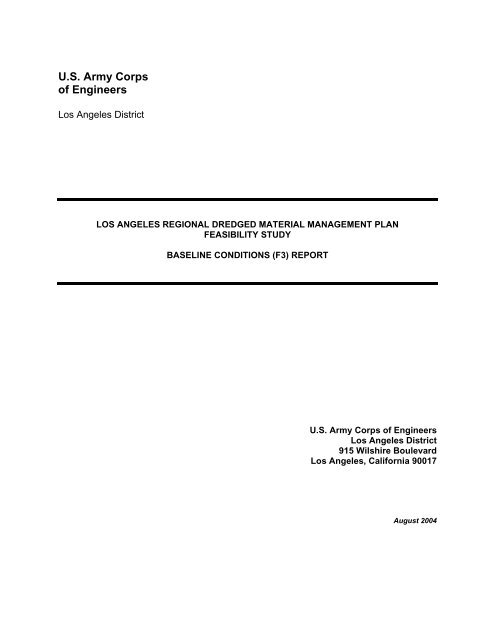
Description of Study Area2 DESCRIPTION OF STUDY AREA2.1 Study AreaThe area of the <strong>Los</strong> <strong>Angeles</strong> Basin for which the <strong>Los</strong> <strong>Angeles</strong> District Corps of Engineers(USACE) Dredge <strong>Material</strong> <strong>Management</strong> <strong>Plan</strong> (DMMP) Feasibility Study (FS) is focused is locatedalong the coastal waters of <strong>Los</strong> <strong>Angeles</strong> County (County). This area extends, generally, fromSanta Monica Bay to the north down to San Pedro Bay to the south. Specific management areasfor the DMMP FS include Marina del Rey and the mouth of Ballona Creek , King Harbor, the Portof <strong>Los</strong> <strong>Angeles</strong> (POLA) and Port of Long Beach (POLB), the mouth of the <strong>Los</strong> <strong>Angeles</strong> RiverEstuary (LARE), and Alamitos Bay (Figure 2-1). Each of these areas has a unique geographicsetting, as described below.2.1.1 Santa Monica BaySanta Monica Bay is an open coastal embayment situated on the western coastline of the County.The bay is bounded on the west by the Santa Monica Basin in the Pacific Ocean, north by PointDume, south by the Palos Verdes Peninsula and Redondo Submarine Canyon, and shoreward bythe <strong>Los</strong> <strong>Angeles</strong> Coastal Plain to the east and Santa Monica Mountains to the north. Marina delRey and King Harbor are major small craft harbors located on the mid-, and southern coast ofSanta Monica Bay. Ballona Creek enters Santa Monica Bay adjacent to the entrance channel ofMarina del Rey. These three locations represent ongoing sources of sediment to this portion of theStudy Area. The Santa Monica Bay and harbors system supports extensive commercial andrecreational use including commercial and recreational boating and fishing, surfing, swimming, andbeach recreational activities.2.1.1.1 Marina del ReyFormally dedicated in April 1965, Marina del Rey was constructed in the area formerly known as thePlaya del Rey Estuary (Figure 2-2). In the past three decades, the harbor has become one of thelargest man-made recreational boat harbors in the world with over 6,000 slips available for privateboaters commercial fishing vessels, and Coast Guard vessels. To protect the harbor against wavedamage during winter storms, a breakwater was constructed perpendicular to the mouth of the harborin January of 1965. The Marina del Rey harbor is operated and maintained by the <strong>Los</strong> <strong>Angeles</strong>County Department of Beaches and Harbors. Navigation within the approach and entrance channelsis maintained by USACE.2.1.1.2 Ballona CreekOriginally a natural, meandering waterway draining runoff from the hills north of Hollywood andthe West <strong>Los</strong> <strong>Angeles</strong> Basin, Ballona Creek was channelized and lined with concrete in 1935 bythe USACE as a flood control measure and now discharges parallel to the entrance channeljetties of Marina del Rey (Figure 2-2). Much of Ballona Creek today is simply a large floodcontrol channel, draining storm water runoff from a large, heavily urbanized area west andnorthwest of downtown <strong>Los</strong> <strong>Angeles</strong>.<strong>Los</strong> <strong>Angeles</strong> <strong>Regional</strong> DMMP FS August 2004Baseline Conditions (F3) Report 16 U.S. Army Corps of Engineers, LA District
PointDumeStudyAreaMarina del ReySanta Monica BayKing HarborPalosVerdesPeninsula<strong>Los</strong><strong>Angeles</strong>RiverEstuaryAlamitosBay024 kmPort of<strong>Los</strong> <strong>Angeles</strong>Port ofLong BeachSan Pedro BayFigure 2-1<strong>Los</strong> <strong>Angeles</strong> <strong>Regional</strong> DMMP Feasibility Study Area
Venice PierBreakwater0 500 meterFigure 2-2Marina del Rey and Ballona Creek
Description of Study AreaDuring winter storm events, significant quantities of sediment are transported down BallonaCreek, where they are trapped behind the breakwater constructed to protect the Marina del Reyharbor instead of flowing into Santa Monica Bay.Operation and maintenance of the flood control channel are partitioned between the USACEand <strong>Los</strong> <strong>Angeles</strong> County Department of Public Works (LACDPW). USACE has jurisdictionbetween Washington Boulevard to La Salle Avenue and Vista del Mar to the Pacific Ocean andLACDPW has jurisdiction over the remainder of the channel. In the portion under its jurisdiction,USACE is responsible for maintenance activities required to maintain the function and structuralperformance of the flood control channel. Other maintenance activities involving aesthetics,water quality, and vector control are performed by LACDPW and Culver City. USACE also hasthe jurisdiction to review and approve proposed improvements or alterations to the BallonaCreek flood control channel to ensure there will not be any adverse effects of flood controlchannel functions. LACDPW may review and approve proposed improvements or alterations tothe Ballona Creek flood control channel within the LACDPW jurisdiction reaches.2.1.1.3 King HarborRedondo Beach − King Harbor is a small craft harbor occupying approximately 60.7 hectares ofland and water at the southern end of Santa Monica Bay. King Harbor is about 27.4 kilometerssouthwest of the business center of the City of <strong>Los</strong> <strong>Angeles</strong> and about 11.3 kilometers south ofthe <strong>Los</strong> <strong>Angeles</strong> Airport (Figure 2-3). It has been an active harbor since the early 1900s when itwas a commercial port. After the POLA became fully operational, Redondo Beach − KingHarbor became focused on pleasure craft and fishing boats. The harbor extends approximately1,219 meters along the coast and is roughly 610 meters wide at the widest point.The City of Redondo Beach is responsible for maintenance of the interior harbor that includesthe three boat basins and the wave protection baffles at the entrances to Basins 1 and 2, builtby the federal government. As part of its Operations and Maintenance Program, USACE isresponsible for maintenance of the breakwaters.2.1.2 San Pedro BaySan Pedro Bay is an open coastal embayment situated on the southern coast of the County.The bay is bounded by Point Fermin on the west, San Pedro Basin on the southwest, NewportSubmarine Canyon on the south, and the coastal plain from San Pedro to Newport Beach alongthe coast.<strong>Los</strong> <strong>Angeles</strong> <strong>Regional</strong> DMMP FS August 2004Baseline Conditions (F3) Report 19 U.S. Army Corps of Engineers, LA District
King HarborBreakwater0200400 meterRedondo BeachPierFigure 2-3Redondo Beach - King Harbor
Description of Study AreaOriginally a large tide flat and salt marsh, the area that was once called Bahia de los Fumos or the“Bay of Smokes” in 1542, later became known as San Pedro Bay. Around the turn of the century(1907) the POLA was created and a few years later in 1911, the POLB was created at the mouth ofthe <strong>Los</strong> <strong>Angeles</strong> River. An aerial view for the two Ports is shown in Figure 2-4. Port developmentgrew rapidly and by 1912 the first section of the breakwater was constructed and the main shippingchannel was dredged to a depth of 9 meters to accommodate the largest vessels of that era.Sediment input into San Pedro Bay occurs via two main upland sources: the Dominquez Channeland the <strong>Los</strong> <strong>Angeles</strong> River. Although not as significant, some sediment transport also occurs intoSan Pedro Bay via coastal currents through the openings in the breakwater that shelters the bay.The Dominquez Channel, previously known as the Dominquez Slough, drains an approximately259 square kilometers watershed located in southern <strong>Los</strong> <strong>Angeles</strong> County. Like all of the otherwaterways in the <strong>Los</strong> <strong>Angeles</strong> Basin, most of the Dominguez Slough was channelized in the mid1900s in an effort to provide flood protection to the County area.2.1.3 <strong>Los</strong> <strong>Angeles</strong> River EstuaryThe LARE is located at the mouth of the <strong>Los</strong> <strong>Angeles</strong> River in Long Beach (Figure 2-5).Queensway Marina, Rainbow Harbor/Marina, and Shoreline Marina are located in the LAREand operated by the City of Long Beach. These facilities serve primarily recreational boatingand cruise ships to Catalina Island.The <strong>Los</strong> <strong>Angeles</strong> River Watershed covers a land area of over 2,135 square kilometers (834square miles) from the eastern portions of Santa Monica Mountains, and Simi Hills, and SantaSusana Mountains to the San Gabriel Mountains in the west. The watershed encompasses andis shaped by the path of the <strong>Los</strong> <strong>Angeles</strong> River, which flows from its headwaters in the mountainseastward to the northern corner of Griffith Park where the channel turns southward through theGlendale Narrows before it flows across the coastal plain and into San Pedro Bay near LongBeach. The <strong>Los</strong> <strong>Angeles</strong> River Watershed has diverse patterns of land use. The upper portion ofthe watershed, 920 square kilometers (approximately 360 square miles), is covered by forest oropen space, while the remaining watershed, 1,215 square kilometers (approximate 474 squaremiles), is highly developed with commercial, industrial, or residential uses.There are eight major tributaries to the <strong>Los</strong> <strong>Angeles</strong> River as it flows from its headwaters to thePacific Ocean. The major tributaries of the <strong>Los</strong> <strong>Angeles</strong> River include Burbank WesternChannel, Pacoima Wash, Tujunga Wash, and Verdugo Wash in the San Fernando Valley; andthe Arroyo Seco, Compton Creek, and Rio Hondo south of the Glendale Narrows. The <strong>Los</strong><strong>Angeles</strong> River Watershed has 22 water bodies within its boundaries including Devil Gates Dam,Hansen Basin, Lopez Dam, Pacoima Dam, and Sepulveda Basin. In addition, there are anumber of spreading grounds in the watershed including sites at Dominguez Gap, theHeadworks, Hansen Dam, Lopez Dam, and Pacoima Dam. The Rio Hondo, a tributary to the<strong>Los</strong> <strong>Angeles</strong> River is hydraulically connected to the San Gabriel River through the WhittierNarrows Reservoir during large storm events.<strong>Los</strong> <strong>Angeles</strong> <strong>Regional</strong> DMMP FS August 2004Baseline Conditions (F3) Report 21 U.S. Army Corps of Engineers, LA District
WestBasinEastBasin<strong>Los</strong> <strong>Angeles</strong>River EstuaryMarine Stadium<strong>Los</strong> CerritosChannelWestBasinEastBasinNorthEnergy IslandBorrow PitIslandWhiteNaplesPier JIslandFreemanSouthEnergy IslandBorrow PitIslandChaffeeLong Beach Breakwater0 1 2 kmFigure 2-4San Pedro BayPort of <strong>Los</strong> <strong>Angeles</strong>, Port of Long Beach, and Alamitos Bay
GoldenShoreEcologicalPreserveQueenswayLandingDowntownLong BeachRainbowHarbor/MarinaShorelineMarinaQueenswayBayQueen MaryPort ofLong Beach0 1000 meterFigure 2-5<strong>Los</strong> <strong>Angeles</strong> River Estuary
Description of Study AreaThe <strong>Los</strong> <strong>Angeles</strong> River, which once flowed freely over the coastal plain, was channelizedbetween 1914 and 1970 to control the runoff and reduce the impacts of major flood events inthe <strong>Los</strong> <strong>Angeles</strong> Region (Region). Today, the <strong>Los</strong> <strong>Angeles</strong> River is lined on 77 km (47.9 miles)of its 82 km (51 miles) length. There are three stretches where the channel bottom is not linedwith concrete reinforcement. They are:• Within the Sepulveda Flood Control Basin• Through the Glendale Narrows• South of Willow Street in Long BeachThe <strong>Los</strong> <strong>Angeles</strong> River, along most of its course, had intermittent flow during much of the yearprior to channelization. In addition, many of its tributaries did not reach the river except duringstorm events. The current flow in the river is effluent dominated with approximately 80 percentof its flow originating at dischargers and the remaining flow coming from storm drain runoff andgroundwater reaching the surface (LACDPW 2003).2.1.4 Alamitos BayAlamitos Bay is located just southeast of the <strong>Los</strong> <strong>Angeles</strong>/Long Beach Harbor Complex inNaples/Belmont Shores (Figure 2-4). The Alamitos Bay Marina was created with the dredgingof marshland in 1949 and opened in the mid 1950s. Today, the marina serves primarilyrecreation boats and is surrounded by residential and commercial areas. Located withinAlamitos Bay Marina are the island of Naples, Marine Stadium that was built for the 1932Olympic rowing competition, and the <strong>Los</strong> Cerritos Channel. Recreational activities includesailing, motor boating, canoeing, kayaking, board sailing, wind surfing, water skiing, and rowing.The Alamitos Bay Marina entrance is defined by two jetties located adjacent to the San GabrielRiver mouth. The City of Long Beach Department of Parks, Recreation, and Marine isresponsible for maintaining the recreational navigation of the harbor entrance and marina andconducts regular maintenance dredging within the entrance channel.2.2 Physical Setting2.2.1 BathymetryThe present bathymetric characteristics of the Study Area reflect the geological movement ofthe Pacific tectonic plate against the North American tectonic plate along the San AndreasFault, which historically resulted in the formation of offshore islands and banks through blockfaulting.A three-dimensional rendering of the bathymetric setting of the Study Area is shown inFigure 2-6.<strong>Los</strong> <strong>Angeles</strong> <strong>Regional</strong> DMMP FS August 2004Baseline Conditions (F3) Report 24 U.S. Army Corps of Engineers, LA District
Marinadel ReyKingHarbor<strong>Los</strong> <strong>Angeles</strong>River EstuaryAlamitosBaySantaMonicaCanyonRedondoCanyonPort of<strong>Los</strong> <strong>Angeles</strong>Port ofLong BeachSMBRC, 2003Figure 2-6Study Area Bathymetry Setting
Description of Study AreaSanta Monica Bay is characterized by a gently sloping continental shelf that extends seaward tothe shelf break at a water depth of approximately 82 meters. At the break, the seafloorbecomes steep along the continental slope but then flattens again as the floor of the deep SantaMonica Basin is approached in approximately 792 meters of water (Terry et al. 1956). Twosubmarine canyons (Santa Monica and Redondo Canyons) cut into the shelf and bracket adistinct, flat offshore bank on the shelf. Bathymetry within Marina del Rey and at the mouth ofBallona Creek is presented in Figure 2-7. Areas of shoaling which require frequent removaloccur just behind the breakwater and at the end of the southern jetty. Bathymetry for theentrance to King Harbor is presented in Figure 2-8. While the USACE does not maintain afederal channel at King Harbor, occasional dredging may be needed to maintain navigablewater depths to the marina.San Pedro Bay consists primarily of the <strong>Los</strong> <strong>Angeles</strong>/Long Beach harbor complex and arelatively flat, wide shelf offshore of the harbor complex. The harbor complex consists of thePOLB in the east and POLA in the west. The bathymetry in the harbor complex featuresnavigation channels that lead to basins and slips in the inner harbors, depressions and islandscreated from industrial operations, and an open water habitat constructed in the <strong>Los</strong> <strong>Angeles</strong>Outer Harbor as part of the Pier 400 expansion. The bathymetry within the harbor complex hasundergone continuous modifications due to the development of the Ports, which has involved aseries of dredge-and-fill operations to deepen the channels so as to accommodate deep-draftvessels and to provide fill for additional land areas for terminal development. Bathymetry datafor the POLA is presented in Figure 2-9 and for the POLB in Figure 2-10.The LARE leads the <strong>Los</strong> <strong>Angeles</strong> River into San Pedro Bay and contains a regularly maintainednavigation channel connecting San Pedro Bay with Queensway Marina. The depth of theestuary ranges from approximately -7 meters mean lower low water (MLLW) at the ocean toapproximately +3 meters MLLW at the terminus of tidal influence near Willow Street.2.2.2 GeologyMany geologic features of the area are resulted from block-faulting − a geological process inwhich large blocks of the Earth’s crust are thrown upwards or downwards, with offshore islandsand banks representing up-thrown blocks and basins down-thrown ones. One of the primarygeological features in the area is the checkerboard pattern of submarine canyons and basinsacross the Pacific margin. Much of the Study Area is the submerged part of the <strong>Los</strong> <strong>Angeles</strong>Coastal Plain that extends from the Santa Monica Mountains to the Santa Ana Mountains and isunderlain by the <strong>Los</strong> <strong>Angeles</strong> Basin as a downthrown block. Sediment eroded from thesurrounding mountains have deposited in the <strong>Los</strong> <strong>Angeles</strong> Basin and raised the surface to thecurrent levels over the past two million years.<strong>Los</strong> <strong>Angeles</strong> <strong>Regional</strong> DMMP FS August 2004Baseline Conditions (F3) Report 26 U.S. Army Corps of Engineers, LA District
Figure 2-7Marina del Rey/Ballona Creek Bathymetry DataSource: U.S. Army Corps of Engineers, <strong>Los</strong> <strong>Angeles</strong> DistrictJan 2003 Survey
Figure 2-8King Harbor Bathymetry DataSource: U.S. Army Corps of Engineers, <strong>Los</strong> <strong>Angeles</strong> DistrictJan 96/May 99 Survey
Figure 2-9Port of <strong>Los</strong> <strong>Angeles</strong> Navigation Channel Bathymetry DataSource: U.S. Army Corps of Engineers, <strong>Los</strong> <strong>Angeles</strong> DistrictJan 2001 Survey
Figure 2-10Port of Long Beach Navigation Channel Bathymetry DataSource: U.S. Army Corps of Engineers, <strong>Los</strong> <strong>Angeles</strong> DistrictOct 2002 Survey
Description of Study AreaThe stability of the seafloor in the Study Area depends on its sedimentary as well as geologicalcharacteristics. The seafloor can be categorized into soft- and hard-bottom types. Even thoughthe proximity of the sediment source can be important, the bottom types are largely a function ofthe movement of the overlying water mass. Much of the Study Area consists of soft-bottomseafloors with fine to coarse, unconsolidated sediments. Hard-bottoms seafloors with exposedbedrocks are present in such areas as the nearshore Region along the Carillo and Malibucoasts from the Ventura-<strong>Los</strong> <strong>Angeles</strong> County line to Pulga Canyon and from Malaga Cove toPoint Fermin on the Palos Verdes Shelf. The submarine canyons in the Study Area often act assediment sinks that collect sediment loads from littoral drift, which in turn contribute to themorphology of the slopes of the deep canyons and the neighboring seafloors.2.2.3 ClimateThe Study Area has a subtropical climate with mild temperatures throughout the year. Theclimate is influenced by the large-scale weather patterns in the Pacific Ocean and by themountain ranges surrounding the coastal plain. Pacific storm paths extend to the Region duringlate fall, winter, and early spring. The Region is covered by marine air most of the year, withoccasional interruption by air from inland, particularly during fall and winter. The overall lowcloudiness, together with the prevalent westerly sea breeze produces generally mildtemperatures throughout the year. The 30-year average daily minimum and maximumtemperatures are approximately 8.9°C in January and 28.9°C in July, respectively. Hightemperatures nearly always occur with low humidity conditions. Haze and fog accompanied bymoist marine layers and light winds frequent the Region. Foggy nights or mornings are rareduring the summer, but account for approximately 25 percent of the nights and mornings duringthe winter.Precipitation in the Study Area occurs primarily during the winter. Measurable precipitationoccurs in approximately 25 percent of the days during the period of late October through earlyApril. In contrast, precipitation during the months of July and August is essentially nonexistentin three years out of four. Relatively infrequent thunderstorms occur over the coastal ranges inthe summer when moist air moves in from the south and southeast. Rainfall amount generallyincreases from the lower-altitude coastal plain to the inland mountains. Annual precipitation onthe coast as measured at the <strong>Los</strong> <strong>Angeles</strong> International Airport is approximately 30.5centimeters (cm) on average, with a range of 7.6 cm in the driest year to 74.7 cm in the wettestyear.2.2.4 OceanographyOceanographic conditions of the Region are briefly described below and a detailed descriptionis given in Chapter 5 of the Technical Appendix.Tides within the Study Area are of mixed, semidiurnal type consisting of two unequal high tidesand two unequal low tides within a tidal period of 24 hours and 50 minutes. Tides in San Pedro<strong>Los</strong> <strong>Angeles</strong> <strong>Regional</strong> DMMP FS August 2004Baseline Conditions (F3) Report 31 U.S. Army Corps of Engineers, LA District
Description of Study AreaBay have a tidal range of approximately 1.7 meters and a mean sea level of approximately 0.9meters MLLW based on the water elevations recorded at NOAA Station 9410660 in <strong>Los</strong><strong>Angeles</strong> Outer Harbor for the National Tidal Datum Epoch (NTDE) of 1983 to 2001 (NOAA2003). The tidal range and datums at different locations within the Study Area vary slightly fromthose recorded in San Pedro Bay as a result of interactions with land forms.Wave conditions in the Study Area result from waves generated by extratropical storms, tropicalstorms, and southern hemisphere extratropical storms. Prefrontal winds and local winds alsogenerate waves of shorter periods within the Region. Extratropical storm swell generated byhistorical severe storm events ranges approximately 4.3 to 10.4 meters high in the deepwaterwith periods of 12 to 22 sec and approach directions of 250 to 289° (USACE 1996b).Occasional occurrences of southeasterly swell of the same category approaching from theMexican coast were also recorded (Strange et al. 1993). The corresponding swell in San PedroBay was estimated to be approximately 2.7 to 5.5 meters high with periods of 12 to 19 sec andapproach directions of 179 to 227° (Strange et al. 1993).Tropical storm waves generated by tropical cyclones approach the Study Area from southeastoff the Mexican coast during northern hemisphere summers. These storms occur approximately15 to 20 times a year and affect the Study Area when taking a southeasterly track. Tropicalstorm swell generated by historical severe storms ranges from 1.8 to 3.4 meters in height indeepwater with periods of 9 to 15 sec and approach directions of 153 to 195° (USACE 1996b).The corresponding swell in San Pedro Bay was estimated to be approximately 1.8 to 4.0 metershigh with periods of 9 to 15 sec and approach directions of 176 to 192° (Strange et al. 1993).Waves generated by prefrontal winds are typically 0.9 to 1.8 meters with periods of 6 to 8 sec.Currents in the Study Area are composed predominantly of large-scale circulation and tidalcurrents. Other processes such as wave-generated longshore currents and rip-currents arelimited to the vicinity of the narrow surf zone along the coastal edges of the Study Area. Thelarge-scale current system within the Southern California Bight consists of the CaliforniaCurrent, Southern California Countercurrent, Southern California Eddy, and CaliforniaUndercurrent. Current speeds vary with location, but are typically 0.09 to 0.2 meters per second(mps) in the Study Area (Hickey 1992). Tidal currents in mid-depths within the Study Area areapproximately 0.07 to 0.12 mps in median speed and 0.15 to 0.21 mps in the highest 10-percentile speed. Near-bottom current speeds are similar to the mid-depth speeds on average(SCCWRP 1993).Coastal sedimentation within the Study Area consists of littoral drift in the nearshore andsedimentation on and near the shelves. Littoral drift is generally dominated by longshoretransport driven primarily by waves and wave-induced currents. Sedimentation on thecontinental shelves is driven by a combination of surface gravity waves, internal waves, andsubtidal currents. Nearshore sedimentation, together with sediment sources and sinks alongthe coast as well as human activities such as beach filling and borrowing, defines the budget of<strong>Los</strong> <strong>Angeles</strong> <strong>Regional</strong> DMMP FS August 2004Baseline Conditions (F3) Report 32 U.S. Army Corps of Engineers, LA District
Description of Study Areasediment for the Study Area shoreline. The net longshore drift in Santa Monica Bay isdowncoast (southward) at a rate of approximately 146,030 to 191,140 cubic meters per year(m 3 /yr) off Santa Monica Beach (USACE 1985; DMJM 1984; USACE 1989; Ingle 1966),151,300 m 3 /yr off Dockweiler Beach, and 167,400 m 3 /yr off Manhattan and Hermosa Beaches(Landrum and Brown 1996).2.3 Existing Coastal StructuresExisting structures along the Study shoreline include Malibu Pier, Santa Monica Breakwater,Santa Monica Pier, Marina del Rey and Ballona Creek jetties, breakwater and harbor complex,Venice Breakwater, Venice Pier, Chevron Groin, Manhattan Beach Pier, Hermosa Beach Pier,King Harbor breakwater and harbor complex, Redondo Beach Pier, Federal Breakwaters, <strong>Los</strong><strong>Angeles</strong>/Long Beach Harbor complex, Belmont Pier and Alamitos Bay jetties.Every structure along the shoreline will, to a certain degree, impact wave, current and littoraltransport along the coast. Some pier structures may only have minor impact, while someoffshore breakwaters play an important role in defining the wave, current and sedimentmovements at certain locations along the shoreline. A brief description of some of the majorstructures along the shoreline of the Study Area is provided below. Locations of thesestructures are shown in Figure 2-11.2.3.1 Malibu PierThe Malibu Pier is located at the northern edge of Santa Monica Bay and extends to 237.7meters. The Frederick Rindge family originally built the Pier in the early 1900s. The Pier wassubsequently purchased in 1943 by William Huber who replaced the pier in 1946 and eventuallysold it to the California State Parks in 1980.2.3.2 Santa Monica Pier and BreakwaterThe Santa Monica Pier is composed of two piers constructed side-by-side with restaurants,shops, a harbor office, boat servicing facilities, and amusement park attractions. The NewcombPier was constructed in 1916 as an all-timber pier. The Municipal Pier was later constructed in1921. The City of Santa Monica constructed the Santa Monica Breakwater in 1934 to provideprotection to the Santa Monica Pier and create a protected harbor area for mooring commercialand recreational boats. The Santa Monica Pier and Breakwater have sustained significantstorm damage, especially from the 1982 to 1983 storm season (USACE 1995). The pier hassince been rebuilt, but not the breakwater.2.3.3 Venice PierThe 390-meter Venice Pier, built in 1963, was severely damaged by the 1980s. It was closedand scheduled for demolition in 1986 but was later restored and reopened in 1997.<strong>Los</strong> <strong>Angeles</strong> <strong>Regional</strong> DMMP FS August 2004Baseline Conditions (F3) Report 33 U.S. Army Corps of Engineers, LA District
12345671. Malibu Pier2. Santa Monica Breakwater and Pier3. Venice Breakwater and Pier4. Marina del Rey Harbor, Breakwater, and Jetties5. Chevron Groin6. Manhattan Beach Pier7. Hermosa Beach Pier8. King Harbor and Redondo Beach Pier9. Federal Breakwater10. Port of <strong>Los</strong> <strong>Angeles</strong> and Long Beach11. Belmont Pier12. Alamitos Bay Marina and Jetties0 2 4 km81091112DeLorme, 1999Figure 2-11Existing Structures
Description of Study Area2.3.4 Marina del Rey Breakwater, Jetties, and Harbor ComplexThe Marina del Rey Harbor provides over 6,000 wet-berthed slips for private pleasure boats,3,000 dry boat storage, and eight lanes of launch ramps for trailer boats and additional boatlaunching facilities. Approximately 12 commercial (fishing and party/cruise) and 12 emergencyvessels also dock in the harbor. The Marina del Rey Harbor Complex entrance is composed offour major structures, the north, middle, and south jetties and a detached breakwater. Themiddle and south jetties were constructed for the Ballona Creek Flood Control project in 1938.These jetties were extended approximately 165 meters in 1947. The harbor developmentinitiated further extension of the middle jetty and construction of the north jetty. The north andmiddle jetties define the harbor entrance and were extended inland in 1959 with the revetmentscompleted in 1962. The harbor was completed in August 1962. The Marina del Rey detachedBreakwater is a 710-meter rubble mound structure that provides wave protection to the harborand entrance jetties. Construction of the breakwater began in 1963 and was completed in 1965(USACE 1993a). Figure 2-2 shows an aerial view of the Marina del Rey harbor entrance. Amajor portion of the sediment discharged from Ballona Creek is trapped behind the detachedbreakwater and subsequently blocks the harbor entrance. The area is dredged regularly by theUSACE to maintain safe navigation conditions for the harbor entrance.2.3.5 Manhattan Beach PierThe Manhattan Beach Pier was constructed by the City of Manhattan Beach during the years1917 to 1920. The roundhouse building was added a year later. Although the roundhouse wasreconstructed in 1992, the pier itself survives as southern California's oldest remaining exampleof early reinforced concrete pier construction.2.3.6 Redondo Beach Pier and King HarborThe “horseshoe-shaped” Redondo Beach Pier was built in 1915 and rebuilt in 1929 after stormdamage. The Redondo Beach/King Harbor Breakwater was originally constructed as a 450-meter long stone breakwater in 1939. The original breakwater did not provide adequate waveprotection for small crafts and induced erosion of the down coast beach. In 1958, thebreakwater was raised to +4.3 meters, MLLW, extended 741 meters, and a 183-meter southbreakwater was constructed. The harbor was opened for berthing by 1965 and a 2.4-meter highseawall constructed at the north breakwater to provide additional wave protection. The seawalldid not provide adequate protection, thus a portion of the north breakwater was raised to a crestelevation +6.7 meters, MLLW in 1964. Wave protection baffles were constructed at the basinentrances in 1977 and are maintained by the City of Redondo Beach. Multiple repairs haveoccurred to fix storm-induced damage to the north breakwater (USACE 1988a).2.3.7 <strong>Los</strong> <strong>Angeles</strong>/Long Beach Harbor ComplexThe POLA and POLB occupy the entire western half of San Pedro Bay to form the nation’slargest harbor complex. As shown in Figure 2-4, the Ports are protected from incoming waves<strong>Los</strong> <strong>Angeles</strong> <strong>Regional</strong> DMMP FS August 2004Baseline Conditions (F3) Report 35 U.S. Army Corps of Engineers, LA District
Description of Study Areaby the Federal Breakwaters which consist of three individual rock structures. The FederalBreakwaters alter the patterns of water exchange between the harbor and the rest of San PedroBay and create unique tidal circulation patterns within the harbor complex.2.3.8 Belmont PierThe Grand Ave Pier was a wooden pier built in 1915. The wooden pier was later demolishedand replaced with the existing 494-meter concrete Belmont Pier in 1966.2.3.9 Alamitos Bay JettiesTwo jetties adjacent to the San Gabriel River mouth define the Alamitos Bay entrance. Thesestone jetties were built prior to the construction of the Alamitos Bay Marina.<strong>Los</strong> <strong>Angeles</strong> <strong>Regional</strong> DMMP FS August 2004Baseline Conditions (F3) Report 36 U.S. Army Corps of Engineers, LA District
Existing (Baseline) Conditions3 EXISTING (BASELINE) CONDITIONSThe existing, or baseline, condition for the <strong>Los</strong> <strong>Angeles</strong> <strong>Regional</strong> Dredge <strong>Material</strong> <strong>Management</strong><strong>Plan</strong> (DMMP) Feasibility Study (FS) includes the actual conditions within the Study Area as theyoccur in the absence of a dredge material management plan, and as of the date of reportpreparation. Factors evaluated include location(s) of dredge materials within the Study Areabased on recent dredging events; physical, chemical, biological, and toxicologicalcharacteristics of “typical” dredge material for each portion of the Study Area; and potentialsources of contamination to the dredge materials within the Study Area.3.1 Dredging History and Disposal PracticeThis section provides a brief summary of historical dredging and disposal practice in the <strong>Los</strong><strong>Angeles</strong> Region (Region). A detailed documentation on the past dredging and disposalactivities in the Study Area is provided in the Technical Appendix.In the last three decades, the Region has generated substantial amounts of dredged materialfrom maintenance and capital improvement projects in its major harbors, marinas, andnavigation channels. Table 3-1 summarizes the historical dredging volumes from majordredging sites in the Region.Table 3-1Dredging Volumes SummaryPeriod ofAvailable Maintenance Dredging Capital Improvement DredgingLocation Record (m 3 ) (m 3 /year) (m 3 ) (m 3 /year)Marina del Rey 1969-1999 1,469,000 49,000 - -Port of <strong>Los</strong><strong>Angeles</strong>1978-2002 2,028,000 85,000 57,563,000 3,386,000Port of LongBeach<strong>Los</strong> <strong>Angeles</strong>River Estuary1976-2003 1,851,000 71,000 14,170,000 664,0001979-2001 1,213,000 86,000 1 - -Alamitos Bay 1994-2002 111,000 14,000 - -<strong>Regional</strong> Total 6,672,000 305,000 71,733,000 4,050,0001. Rate based on records between 1990 and 2001.The dredging history in the Region based on available records indicates that a total ofapproximately 6.7 million cubic meters (m 3 ) of maintenance dredge material has beengenerated from harbor and channel projects over the past three decades at an annual rate ofapproximately 305,000 cubic meters per year (m 3 /yr). Over that same period of time,approximately 72 million m 3 of dredge material has been generated from capital improvementprojects in the Ports at an annual rate of about 4 million m 3 /yr. The data indicate that theregional total dredging volume and rate associated with capital improvement projects are over10 times those of maintenance projects, which suggests that capital improvement projects in thePorts have been the dominant dredge material generator in the Region.<strong>Los</strong> <strong>Angeles</strong> <strong>Regional</strong> DMMP FS August 2004Baseline Conditions (F3) Report 37 U.S. Army Corps of Engineers, LA District
Existing (Baseline) ConditionsDisposal practices in the Region include harbor infill, open ocean disposal, nearshore openwater disposal, beach fill, shallow water habitat fill, and stockpiling. Table 3-2 presents disposalquantities, by method, for dredge materials from the major sources in the Region. Harbor infillincludes records for Port fill activities and confined disposals. Open ocean disposal refers todisposal at U.S. Army Corps of Engineers/U.S. Environmental Protection Agency (Corps/EPA)sites such as LA-2 or LA-3. Nearshore open water refers to disposal records for nearshore andborrow pit (e.g., North Energy Island Borrow Pit). Beach fill includes beach placement andnourishment. Shallow water habitat (SWH) indicates disposal at locations to create SWH.Stock piling refers to the disposal of dredge material at the Anchorage Road Soil Storage Site(ARSSS) for the Port of <strong>Los</strong> <strong>Angeles</strong> (POLA) and Western Anchorage for the Port of LongBeach (POLB). The mixed disposal method refers to the combination of harbor infill andshallow water habitat disposal records in which the volume breakdown for each method was notavailable. Volumes from disposal events with methods that are indeterminate from availablerecords are grouped under “unspecified.”Table 3-2Disposal Method Volumes SummaryDisposalMethodMarina delRey (m 3 )Port of <strong>Los</strong><strong>Angeles</strong> (m 3 )Port of LongBeach (m 3 )<strong>Los</strong> <strong>Angeles</strong>RiverEstuary (m 3 )AlamitosBay (m 3 )<strong>Regional</strong>Total (m 3 )Percentof TotalHarbor Infill 438,000 41,133,000 4,650,000 410,000 - 46,631,000 60%Open Ocean 40,000 3,154,000 5,661,000 297,000 - 9,152,000 12%NearshoreOpen Water16,000 36,000 4,970,000 395,000 - 5,417,000 7%Beach Fill 931,000 - - - 111,000 1,042,000 1%ShallowWater Habitat44,000 2,572,000 - - - 2,616,000 3%Stock Piling - 245,000 739,000 - - 984,000 1%Mixed 1 - 12,435,000 - - - 12,435,000 16%Unspecified - 17,000 - 111,000 - 128,000 0%1. Disposal recorded as either harbor infill or shallow water habitat (not differentiated).Disposal data indicates that approximately 60 percent (46.6 million m 3 ) of the total historicalvolume of dredge material from the Region has been used as infill for harbor infrastructuredevelopment and expansion projects at the POLA and POLB. This is followed by 12 percentdisposed offshore at designated ocean disposal sites including LA-2 and LA-3, and 7 percent atnearshore disposal sites such as the Energy Island Borrow Pits. Beach fill and shallow waterhabitat fill, two of the primary beneficial reuses practiced in the Region, have accounted forapproximately 1 percent and 3 percent of the total disposal volume in the Region, respectively.Less than 1 percent of the total historical volume generated in the Region has been kept forstock piling at the Ports’ storage facilities. A significant 16 percent of the total volume wasdisposed as “mixed” that included both harbor infill and SWH. This volume was from two of thecapital improvement projects at the POLA. The unspecified disposal volumes were minimalrelative to the total dredge volume.<strong>Los</strong> <strong>Angeles</strong> <strong>Regional</strong> DMMP FS August 2004Baseline Conditions (F3) Report 38 U.S. Army Corps of Engineers, LA District
Existing (Baseline) ConditionsHistorical dredge records did not provide sufficient information on the volumetric breakdownbetween statutorily contaminated and uncontaminated (clean) dredge material on a project-byprojectbasis. Assuming only clean material would be allowed for ocean disposal or beach fill,at least 10.2 million m 3 (13 percent) of the dredged material listed in Table 3-2 could beconsidered as clean sediment. The remaining 68.2 million m 3 (87 percent); however, may notnecessarily all be contaminated. This is because sediment that was deemed unsuitable forocean disposal or for beach placement might actually consist of a mix of clean andcontaminated material. Also, Port Capital Improvement projects frequently rely on the mostsuitable materials for construction (e.g. sands), regardless of contaminant level. There were noattempts in past projects to physically separate the clean sediments from the contaminatedsediments so that they can be disposed of accordingly, so the true historical ratio of clean vs.contaminated is difficult to estimate. Based on historical sediment testing results, USACEestimates that about 20 to 25 percent of the dredged material at both Marina del Rey and <strong>Los</strong><strong>Angeles</strong> River Estuary (LARE) were actually contaminated.3.2 <strong>Regional</strong> <strong>Dredged</strong> <strong>Material</strong> CharacteristicsAs mentioned previously, the Study Area comprises two predominant sub-areas − SantaMonica Bay, which includes Marina del Rey and the mouth of Ballona Creek, and San PedroBay, which includes the LARE, Alamitos Bay and the POLA and POLB. The watersheds withinthe Study Area are shown in Figure 3-1. Each area contains different sediment sources anddepositional systems, which affect the need for dredging frequency, physical characteristics,contaminant concentrations, and available management options. This section summarizes“typical” dredge material characteristics for each portion of the Study Area as they exist today.Much of the information presented in this section relative to sediment sources, physicalproperties and chemical concentrations are extracted from the regional sediment databasecreated by the <strong>Los</strong> <strong>Angeles</strong> Contaminated Sediments Task Force (CSTF). This databasecontains all of the known dredge material suitability characterization data collected within theStudy Area over the past 20 years.A caveat to the data contained in the database, and summarized in this report, is that most wascollected primarily for determining dredge material suitability for open ocean (in-water) disposal.As a result, dredging projects conducted solely for use as fill in capital improvement projectsmay not have been subjected to the same rigorous chemical and biological testing. In addition,dredging projects specifically for beach nourishment were determined to be clean for contactwater recreation (REC-1) beneficial use and hence will not be included in the database. As aresult, the data contained in the database and the summaries presented in this report, maypotentially be skewed towards areas more susceptible to containing fine-grained andcontaminated sediments. Where possible, notes are added to clarify specific areas typically notfully characterized prior to disposal.<strong>Los</strong> <strong>Angeles</strong> <strong>Regional</strong> DMMP FS August 2004Baseline Conditions (F3) Report 39 U.S. Army Corps of Engineers, LA District
Figure 3-1 3-2Major Watersheds in the Study Area
Existing (Baseline) Conditions3.2.1 Santa Monica BayWithin Santa Monica Bay, sediment management activities covered by the <strong>Los</strong> <strong>Angeles</strong> DMMPFS are limited to Marina del Rey, the mouth of Ballona Creek, and the jetty located at the mouthof King Harbor. Sediment characterization data (other than bathymetry and grain size) is readilyavailable for Marina del Rey and Ballona Creek, but only one record exists for King Harbor. Assuch, the majority of the data presented in this section will be limited to the former two locations.3.2.1.1 Sediment Source(s)Sediment input to Marina del Rey is limited to discharge from Ballona Creek and littoraltransport from wind and waves along adjacent beaches. Previous studies (SCCWRP 1996)suggest that Malibu Creek is also a sediment source to the bay as a whole, but that its runoff isnot contaminated, like that from Ballona Creek. This is likely a result of the different drainagepatterns for the two different watersheds. Malibu Creek drains mostly undeveloped areas ofMalibu Canyon while Ballona Creek drains highly developed areas of West <strong>Los</strong> <strong>Angeles</strong>.3.2.1.2 Physical CharacteristicsTypical physical characteristics of Marina del Rey/Ballona Creek dredge material are detailed inSection 4 of the Technical Appendix for this report. Sand content typically ranges from 51.2percent to 97.9 percent with an average of 79.3 percent; Silts range from less than 1 percent toalmost 67 percent, with an average of 25.5 percent; and clays range from less than 1 percent to59.5 percent with an average of 17 percent. Gravel is rarely encountered in Marina del Reydredged material, averaging only 2.5 percent. Because of the high sand content typically foundin Marina del Rey/Ballona Creek dredge material, this material has historically been suitable forbeach nourishment, when not contaminated.3.2.1.3 Chemical & Toxicological CharacteristicsChemical and toxicological properties of typical dredge material from Marina del Rey/BallonaCreek are detailed in Section 4 of the Technical Appendix for this report. In summary, inorganicconcentrations frequently exceed conservative toxicity reference values for sediments (ER-L’s[effects range-low] and ER-M’s [effects range-median]). Semi-volatile organic concentrations(SVOA), while frequently detected, rarely exceeded the screening values.Dichlorodiphenyltrichloroethane (DDT) and Polychlorinated Biphenyls (PCBs) were alsofrequently detected, but at concentrations that may pose ecological effects concerns. Chemicalresults for King Harbor show all metals and organics below sensitive threshold concentrations.3.2.1.4 Source of ContaminationContaminant sources to Santa Monica Bay are limited to marine vessel activities and stormwater runoff from Ballona Creek. Marina del Rey currently houses the largest concentration ofprivate marine vessels in the United States. Contaminant sources related to marine vesselsinclude engine emissions, bilge pump and sewage releases, and incidental fuel and oil spills.<strong>Los</strong> <strong>Angeles</strong> <strong>Regional</strong> DMMP FS August 2004Baseline Conditions (F3) Report 41 U.S. Army Corps of Engineers, LA District
Existing (Baseline) ConditionsThe greatest source of contaminants to the area, however, is storm water runoff from BallonaCreek (SCCWRP 2003).3.2.1.5 Biological CommunityThe biological community supported by sediments in Santa Monica Bay is detailed in Section 6of the Technical Appendix to this report. A wide range of invertebrates and vertebrates arecommon to the area, including many recreationally important species such as California spinylobster, clams, grunion, white sea bass, and California halibut. These and many more speciescould be potentially at risk due to dredging and disposal operations in the area..3.2.2 San Pedro Bay – Port of <strong>Los</strong> <strong>Angeles</strong>The POLA is one of three primary management areas covered by the DMMP within San PedroBay. Lease hold areas for the POLA are shown in Figure 2-4. The following sectionssummarize the physical and chemical characteristics of dredge material from this area.3.2.2.1 Sediment Source(s)The source of sediment to the POLA harbor complex is predominantly external and mostlyassociated with inflow within the shipping channel arriving through the Angel’s Gate opening inthe Federal Breakwater, and runoff from the Dominguez Channel which discharges to theConsolidated Slip. At low tides, fully loaded ships may also contribute to the inflow of sedimentby pushing bow wakes of fine grained materials into the back channels of the port complex.These fine grained materials are then typically deposited along the wharfs and structures thatline portions of the channels, and in the depositional areas at the head of the terminal slips.3.2.2.2 Physical CharacteristicsTypical physical characteristics for dredge material from the POLA are detailed in Section 4 ofthe Technical Appendix for this report. Sand contents range from 2 percent to 99 percent, withan average of 55 percent; silt contents range from 0 percent to 80 percent, with an average ofalmost 28 percent; and clay contents range from 0 percent to 47 percent with an average 2percent. Detailed evaluation of the individual studies suggests the more sandy material islocated in the outer harbor area nearest the federal channel. Sediments from the inner harborand wharf faces is typically higher in silts and thus, less suitable for nourishment or constructionalternatives.3.2.2.3 Chemical and Toxicological CharacteristicsChemical and toxicological properties of typical dredge material from the POLA are also detailedin Section 4 of the Technical Appendix for this report and summarized in this section. Overall,chemical concentrations were highly variable, ranging from concentrations that were barelydetectable to values typically considered as moderately contaminated. Inorganic, semi-volatile,and pesticide/PCB concentrations frequently exceed conservative toxicity reference values for<strong>Los</strong> <strong>Angeles</strong> <strong>Regional</strong> DMMP FS August 2004Baseline Conditions (F3) Report 42 U.S. Army Corps of Engineers, LA District
Existing (Baseline) Conditionssediments (ER-L’s and ER-M’s) at some locations which may pose ecological effects concerns.Some of these areas (e.g., Consolidated Slip) are currently targeted for future remediation.3.2.2.4 Source of ContaminationSources of contamination to POLA sediments include the Dominguez Channel, which drains aheavily industrialized area of San Pedro adjacent to the Port, and has historically beencontaminated with metals and DDT. As a result, the sediments located at the point of dischargeinto the back channels of the port (the Consolidated Slip) are heavily contaminated and maycontribute to greater spatial contamination through resuspension during storm flow. Additionalsources of contamination to the area include marine vessel activities and storm water runoff(e.g., West Basin storm drain).3.2.2.5 Biological CommunityThe biological community supported by sediments within the POLA harbor complex wasdetailed in study conducted by MEC Analytical Systems (MEC) in 2000. That study issummarized in Section 6 of the Technical Appendix for this report. Within the harbor complexseveral recreationally important species can be found including the California spiny lobster,white sea bass, and California halibut.3.2.3 San Pedro Bay – Port of Long BeachAnother major management area covered by the DMMP in San Pedro Bay is the POLB, whichis located adjacent to the POLA. Combined the two Ports form the third largest port complex inthe world. The following sections summarize the physical and chemical characteristics ofdredge material from this area.3.2.3.1 Sediment Source(s)The predominant sources of sediment to the POLB are associated with inflow from the shippingchannel arriving through the Queen’s Gate opening in the Federal Breakwater, and runoff fromthe LARE which discharges to the south of the harbor complex. As with the POLA, it is possiblethat fully loaded ships arriving at low tides may also contribute to the inflow of sediment bypushing bow wakes of fine grained materials into the back channels of the port complex. Thesefine grained materials are then typically deposited along the wharfs and structures that lineportions of the channels, and in the depositional areas at the head of the terminal slips.3.2.3.2 Physical CharacteristicsTypical physical characteristics for dredge material from the POLB are detailed in Section 4 ofthe Technical Appendix for this report. Sand contents range from 4 percent to 99 percent, withan average of 44 percent; silt contents range from 1 percent to 77 percent, with an average of37 percent; and clay contents range from 0 percent to 43 percent with an average 16 percent.<strong>Los</strong> <strong>Angeles</strong> <strong>Regional</strong> DMMP FS August 2004Baseline Conditions (F3) Report 43 U.S. Army Corps of Engineers, LA District
Existing (Baseline) ConditionsAs with the POLA, POLB sediments are highly variable with courser grained materials typicallypresent in the outer harbor and fine-grained materials in the back channels and berth areas.3.2.3.3 Chemical & Toxicological CharacteristicsChemical and toxicological properties of typical dredge material from the POLB are similar tothat observed for the POLA. The properties are detailed in Section 4 of the Technical Appendixfor this report and summarized in this section. Overall, chemical concentrations were highlyvariable, ranging from concentrations that were barely detectable to values typically consideredas moderately contaminated. Inorganic, semi-volatile, and pesticide/PCB concentrationsfrequently exceed conservative toxicity reference values for sediments (ER-L’s and ER-M’s) atsome locations, which may pose ecological effects concerns. Some of these areas (e.g., formerNavy Mole area) are currently identified for future remediation.3.2.3.4 Source of ContaminationSources of contamination to POLB sediments include the <strong>Los</strong> <strong>Angeles</strong> River, which drains alarge residential and industrial use area south of <strong>Los</strong> <strong>Angeles</strong>, general marine vessel activitiesand storm water runoff. The <strong>Los</strong> <strong>Angeles</strong> River, which has historically been contaminated withmetals and Polycyclic Aromatic Hydrocarbons (PAHs), has been shown in satellite imagery tospread sediments throughout the southern portion of San Pedro Bay.3.2.3.5 Biological CommunitySimilar to the POLA, the biological community supported by sediments within the POLB harborcomplex was detailed in study conducted by MEC (2000). That study is summarized in Section6 of the Technical Appendix for this report. Within the harbor complex several recreationallyimportant species can be found including the California spiny lobster, white sea bass, andCalifornia halibut.3.2.4 San Pedro Bay – <strong>Los</strong> <strong>Angeles</strong> River EstuaryThe third major management area within San Pedro Bay is the LARE. The LARE is located atthe mouth of the <strong>Los</strong> <strong>Angeles</strong> River in the City of Long Beach. Maintenance dredging occurs atthe site approximately every one to three years, depending on the severity of sedimentationresulted from storm-related runoff. The following sections summarize the physical and chemicalcharacteristics of dredge material from this area.3.2.4.1 Sediment Source(s)The primary source of sediment to the LARE is urban runoff within the <strong>Los</strong> <strong>Angeles</strong> Riverwatershed that is shown in Figure 3-1. There are eight major tributaries to the <strong>Los</strong> <strong>Angeles</strong>River as it flows from its headwaters to the Pacific Ocean. The major tributaries of the <strong>Los</strong><strong>Angeles</strong> River include Burbank Western Channel, Pacoima Wash, Tujunga Wash, and Verdugo<strong>Los</strong> <strong>Angeles</strong> <strong>Regional</strong> DMMP FS August 2004Baseline Conditions (F3) Report 44 U.S. Army Corps of Engineers, LA District
Existing (Baseline) ConditionsWash in the San Fernando Valley; and the Arroyo Seco, Compton Creek, and Rio Hondo southof the Glendale Narrows.3.2.4.2 Physical CharacteristicsTypical physical characteristics for dredge material from the LARE are detailed in Section 4 ofthe Technical Appendix for this report. Sand contents range from 19 percent to 97 percent, withan average of 61 percent; silt contents range from 1 percent to 45 percent, with an average of24 percent; and clay contents range from 2 percent to 36 percent with an average 13 percent.3.2.4.3 Chemical and Toxicological CharacteristicsChemical and toxicological properties of typical dredge material from the LARE are similar tothat observed for the two Ports with regards to metals, semi-volatiles, and PAHs. Pesticidesand PCBs, on the other hand, are rarely detected in LARE sediments, but are more commonlyobserved at the ports. The properties are detailed in Section 4 of the Technical Appendix forthis report and summarized in this section. Overall, chemical concentrations were highlyvariable, ranging from concentrations that were barely detectable to values typically consideredas moderately contaminated. Inorganic, semi-volatile and PAH concentrations frequentlyexceed conservative toxicity reference values for sediments (ER-L’s and ER-M’s) which maypose ecological effects concerns.3.2.4.4 Source of ContaminationThe source of contamination to dredge material within the LARE is primary contributed fromurban runoff occurring within its tributaries. Because of the very large surface area, much ofwhich is paved, metals and PAHs are frequently a concern. Storm water runoff carries metalsfrom vehicle exhaust; and oil and grease compounds from all types of motor vehicles into thecollector drains, which in turn end up in the various flood control channels draining into the <strong>Los</strong><strong>Angeles</strong> River. The chemicals become attached to sediment particles as they travel down thechannels to the mouth of the LARE. At the mouth of the LARE, water velocities dissipatecausing the heavier sediment particles settle out, clogging the navigational channel to theQueensway Marina.3.2.4.5 Biological CommunityThe biological community of the LARE, which is detailed in Section 6 of the Technical Appendixto this report, is similar to the rest of the San Pedro Bay in that similar habitats are present asare similar organisms. Within the LARE several recreationally important species can be foundincluding juvenile white sea bass and California halibut.3.2.5 Alamitos BayAlamitos Bay is located just outside the southern boundary of San Pedro Bay. Because of itsclose proximity, it shares many of the same habitats as San Pedro Bay. Physically, the material<strong>Los</strong> <strong>Angeles</strong> <strong>Regional</strong> DMMP FS August 2004Baseline Conditions (F3) Report 45 U.S. Army Corps of Engineers, LA District
Existing (Baseline) Conditionsis similar to that found in San Pedro Bay. Chemically, however, it is very different with muchlower chemical concentrations.Dredging in Alamitos Bay occurs annually near the mouth of the harbor where the City of LongBeach typically removes approximately 14,000 m 3 and disposes the material on the adjacentbeaches. The following sections briefly describe the baseline physical and chemical features ofthe dredge material.3.2.5.1 Sediment Source(s)Because there are no major creeks or rivers that flow into Alamitos Bay, sediment sources arelimited to storm water drainage canals and tidal flow into the bay. The San Gabriel Riverdischarges into the Pacific Ocean adjacent to the mouth of the bay and may result in somesediment transport into the bay. Sedimentation along the navigation channel that requiresregular maintenance dredging, however, is mainly due sediment transport by waves into thechannels.3.2.5.2 Physical CharacteristicsSediment physical data available for Alamitos Bay is limited to only a few samples collectedduring the Bay Protection and Toxic Cleanup Program / National Oceanic and AtmosphericAdministration (BPTCP/NOAA) study and observations made during annual dredging by theCity of Long Beach. Based on this very limited dataset, it appears the dredge material containslower silt contents than the other management areas. A more detailed summary of the availabledata can be found in Section 4 of the Technical Appendix to this report.3.2.5.3 Chemical and Toxicological CharacteristicsChemical and toxicological properties of typical dredge material from Alamitos Bay is differentfrom the other management areas in that chemical concentrations are much lower, and hencethe expected potential for sediment toxicity is also much lower. The chemical properties for theavailable Alamitos Bay material are detailed in Section 4 of the Technical Appendix for thisreport. There may be other areas of Alamitos Bay, however, with higher chemicalconcentrations (e.g., Colorado Lagoon) that have not yet been fully characterized. Availability ofthis data might alter the information summarized in this section.3.2.5.4 Source of ContaminationAs mentioned in the previous section, very little sediment data is available for Alamitos Bay andthat which is available does not indicate the presence of sediment contamination.3.2.5.5 Biological CommunityThe biological community of Alamitos Bay, which is detailed in Section 6 of the TechnicalAppendix to this report, is similar to that found in San Pedro Bay because similar habitats are<strong>Los</strong> <strong>Angeles</strong> <strong>Regional</strong> DMMP FS August 2004Baseline Conditions (F3) Report 46 U.S. Army Corps of Engineers, LA District
Existing (Baseline) Conditionspresent as are similar organisms. Within the bay, several recreationally important species canbe found including juvenile white sea bass and California halibut.3.3 Biological Resources in the Study AreaThe following summarizes the existing without-project biological resources found within theStudy Area. For a more detailed baseline conditions description of the biological resources thatexist within the Study Area, refer to Section 6 of the Technical Appendix for this report.3.3.1 HabitatsThe DMMP FS Study Area is located along the coastal waters of <strong>Los</strong> <strong>Angeles</strong> County (County)extending from Santa Monica Bay south to Alamitos Bay. This nearshore environment supportsa wide variety of key biological habitats. Aquatic habitats include pelagic (shallow and deepwaters), benthic (soft bottom and hard substrate), and kelp beds. Terrestrial habitats includewetlands intertidal mudflats, salt marshes and sandy beaches. Wetland habitats along theshoreline within the Study Area are limited due to a long history of development in the area.Sporadic areas of pickleweed (Salicornia virginica) and saltgrass (Distichlis spicata) patcheshave been documented along minimally developed harbor shorelines (MBC 1999).3.3.2 Biological CommunitiesDespite the rapid growth and development of the coastal zone of the County, the area supportsa very diverse biological community. The waters support a huge recreational and commercialfishery for both migratory and resident species.<strong>Plan</strong>kton communities within the Study Area represent those that are commonly found along thesouthern California coast. Phytoplankton communities are dominated by diatom blooms in thespring and dinoflagellate blooms in the fall. Zooplankton communities are dominatedthroughout the year by copepods and show clear seasonal patterns of abundance (Dawson andPieper 1993). Maximum zooplankton biomass occurs between April and June and the minimumis between December and February.The Study Area is a transient or permanent habitat for numerous juvenile, adult and larval fishspecies (Horn and Allen 1981; MEC 2002). Fish communities are generally dominated bynorthern anchovy (Engraulis mordax), white croaker (Genyonemous lineatus) queenfish(Seriphus politus), topsmelt (Atherinopsaffinis), and Pacific sardine (Sardinoops sagax) (Brewer1983; MEC 2002). Abundance varied with season and habitat with significantly higherabundances during the summer in the shallow water habitats than in other seasons and deeperopen water habitats (MEC 2002). Larval fish abundance is dominated by a variety of gobyspecies, northern anchovy, California clingfish (Gobiesox rhessondon), queenfish and whitecroaker.<strong>Los</strong> <strong>Angeles</strong> <strong>Regional</strong> DMMP FS August 2004Baseline Conditions (F3) Report 47 U.S. Army Corps of Engineers, LA District
Existing (Baseline) ConditionsBenthic communities found in soft bottom habitats in the Study Area are dominated by the nonindigenouspolychaete (Pseudopolydora paucibranchiata), the amphipod (Amphideutopusoculatus), the ostracod (Euphilomedes carcharodonta), clam (Theora lubrica), and thepolychaete worms (Cossura sp. A, Euchone limnicola, Mediomastus spp., and Monticellinasiblina) (MEC 2002).Benthic organisms residing on hard substrates such as piers, jetties and breakwaters, within theStudy Area typically include barnacles, bivalves, polychaete worms, snails, anemones,echinoderms, and algae. The hard substrate communities often include the bay mussel (Mytilusgalloprovincialis) and the Pacific oyster (Crassostrea gigas).Kelp and macroalgae found along the nearshore coast of the Study Area are dominated bysparse coverage of stress tolerant algal species such as Ulva spp. and Enteromorpha spp;more exposed areas are typically dominated by red and brown algal species, includingSargassum spp., Taonia spp., Gigartina spp., and Corallina spp. (USACE and LAHD 1984)Giant Kelp (Macrocystis sp.) is found along the inner side of breakwaters and along rock dikesin the outer bay (MEC 2002).California sea lions (Zalophus californianus) are the most abundant pinniped in the southerncoastal waters of the Study Area (NOAA 2000b). Transient marine mammals most commonlyobserved along the outer areas of the Study Area include the short-beaked common dolphin(Delphinus delphis), bottle nose dolphins (Tursiops truncates), Risso’s dolphins (Grampusgriseus), and Pacific white-sided dolphins (Lagenorhynchus obliquidens). In the fall and spring,a transient population of blue whales (Balaenoptera musculus), humpback whales (Megapteranovaeangliae) and California Grey Whales (Eschrichtius robustus) are found foraging off thecoastal waters as they migrate up and down the coast.Over 100 bird species have been reported to occur within the Study Area (MEC 2002). Ofthese, 70 percent could be considered water-associated, and 44 percent of all birds observed inthe harbors over the year were gulls (MEC 2002). Other abundant taxa include terns, grebes,California brown pelican (an endangered species), and cormorants.3.3.3 Sensitive and Recreationally Important SpeciesSensitive and/or recreationally important fish species found within the Study Area includeCalifornia halibut, California white sea bass, and the northern anchovy. Special interest fishspecies include the California grunion.Eelgrass is an important component of estuarine ecosystems and is considered a “SpecialAquatic Site” under the Clear Water Act. It provides food and habitat for many birds, fish, andinvertebrates and is found sporadically within the Study Area.<strong>Los</strong> <strong>Angeles</strong> <strong>Regional</strong> DMMP FS August 2004Baseline Conditions (F3) Report 48 U.S. Army Corps of Engineers, LA District
Existing (Baseline) ConditionsThe California least tern (Sterna antillarum browni), the California brown pelican (Pelecanusoccidentalis californicus), and the western snowy plover (Charadrius alexandrinus nivosus) arethe primary bird species found in the Study area that are protected by the Endangered SpeciesAct (ESA) of 1973.Several species of birds protected by the Migratory Bird Treaty Act, including the elegant tern(Sterna elegans), caspian tern (Sterna caspia), royal tern (Sterna maxima), black skimmer(Rynchops niger), black oystercatcher (Haematopus bachmani), and great blue heron (Ardeaherodias), have been observed nesting in San Pedro Harbor (MEC 2002). Individuals of thesespecies not only use the Harbor for breeding but forage on fish in the harbor (MEC 1988).3.4 Water QualitySome areas within the urbanized portions of the Study Area that are typically dredged havebeen shown to be degraded. Several of the management areas of focus for this study areincluded on the State of California 2002 CWA 303(d) list of impaired waters. A summary ofapplicable 303(d) listings is presented in Table 3-3.Table 3-3 Summary of 303(d) Listings for the Dredge <strong>Management</strong> Areas in<strong>Los</strong> <strong>Angeles</strong> County<strong>Management</strong> Area Metals Pesticides PCBS PAHsFecalColiformBallona Creek √ √ √ √Ballona Creek Estuary √ √ √ √ √Cabrillo Beach √ √ √Dominguez Channel √ √ √ √ √Long Beach Harbor Main Channel √ √ √<strong>Los</strong> <strong>Angeles</strong> Fish Harbor √ √ √Consolidated Slip √ √ √ √<strong>Los</strong> <strong>Angeles</strong> Inner Harbor √ √ √<strong>Los</strong> <strong>Angeles</strong> Harbor Main Channel √ √ √ √<strong>Los</strong> <strong>Angeles</strong> Harbor SW Slip √ √<strong>Los</strong> <strong>Angeles</strong> River Estuary √ √ √<strong>Los</strong> <strong>Angeles</strong> River 1 √ √<strong>Los</strong> Cerritos Channel √ √ √Marina del Rey Harbor √ √ √ √1. Also contains 303(d) listings for nutrients and organics.3.5 Commercial and Recreational Resources3.5.1 Santa Monica Bay3.5.1.1 Marina del ReyMarina del Rey has multiple hotels and restaurants located throughout the harbor area.Fisherman’s Village offers sightseeing, shopping, eating, and equipment rentals. Special<strong>Los</strong> <strong>Angeles</strong> <strong>Regional</strong> DMMP FS August 2004Baseline Conditions (F3) Report 49 U.S. Army Corps of Engineers, LA District
Existing (Baseline) Conditionsspectator events include the annual Christmas Boat Parade, California Cup Race, regattas,crew races, and park concerts. The harbor area hosts a number of parks include Burton W.Chace, Admiralty, Harold Edgington, and A.E. Austin Parks that offer outdoor leisure activities.Mother’s Beach, known for its shallow, calm water, provides a sandy beach and boating lagoonfor beach activities and windsurfing. Other facilities around the harbor serving recreationalpurposes include the UCLA Boathouse, Pardee Scout Sea Base, and <strong>Los</strong> <strong>Angeles</strong> CountySouth Bay Bicycle Trail.The Marina del Rey harbor consists of 1.64 square kilometers of water and is the largest manmadesmall-craft harbor in the world. The harbor provides over 6,000 wet-berthed slips, 3,000dry boat storages, eight lanes of launch ramps for trailer boats, 240 boat launch facilities, 640-meter transient/guest docks, charter and rental boats, harbor tours, sailing instructions, andrepair yards. Approximately 12 commercial boats (fishing and party/cruise) and 12 emergencyvessels dock in the harbor. Commercial and recreational activities include charter boat fishing,sport fishing, dining cruises, wind surfing, jet skiing, and sail boarding. Two entrance jetties andan offshore breakwater form the harbor entrance. The harbor jetties are regularly used forsightseeing, bicycling, fishing, and walking.Different boat types use the harbor at different time. Fishing boats generally leave early in themorning and return in the early afternoon as winds pick up, a time when sailboats typically goout for sail. Approximately 25 to 30 percent of the wet-berthed sailboats and 15 to 25 percent ofthe wet-berthed power boats were observed to operate on summer Sundays. Winter weekdaysare typically periods of lowest usage.3.5.1.2 King HarborKing Harbor offers a small boat launch, sport fishing pier, restaurants, commercial and retailshops, a hotel, and apartments. Parks include Seaside Lagoon, a saltwater, sand bottom pool,Czuleger Park (Plaza Park), Veterans Park and Community Center, and Redondo State Beach.Other recreational activities include fishing from the pier, boats for sport fishing and whalewatching, ocean racer, charters, sailing classes, bike rentals, wave runner rentals, and rollerskating/rollerblading.King Harbor is a recreational harbor serving primarily pleasure craft and fishing boats. Over1,450 slips are available and can accommodate vessels ranging from 4.3 meters to 25.3meters. Harbor amenities include tenant lounges, hot shower and laundry rooms, mailboxes,landlockers, dingy racks and secured parking. Other boating services include two yacht clubs, amarine hardware store and repair yard, fuel dock and free pump out station.The King Harbor is separated into three basins, two large and one small, with a large entrychannel. The harbor services vessels, which range from small craft to boats 27.4 meters inlength. The harbor entrance is 183 meters wide, which is adequate navigation need for thecommercial and residential vessels using the harbor basins.<strong>Los</strong> <strong>Angeles</strong> <strong>Regional</strong> DMMP FS August 2004Baseline Conditions (F3) Report 50 U.S. Army Corps of Engineers, LA District
Existing (Baseline) Conditions3.5.2 San Pedro Bay3.5.2.1 Ports of <strong>Los</strong> <strong>Angeles</strong> and Long BeachSan Pedro Bay within the <strong>Los</strong> <strong>Angeles</strong> Harbor is home to commercial and sport fishing fleetsand supports recreational activities including sport fishing, harbor cruising, diving, jet skiing,sailing, swimming, and windsurfing. Areas around the harbor area offer shoreline restaurantsand waterfront walks. Major attractions include Ports O’Call Village, Cabrillo Marine Aquarium,Cabrillo Beach, and Cabrillo Beach Pier.San Pedro Bay within the Long Beach Harbor supports boating activities from Downtown LongBeach Harbor Marina and Alamitos Bay Marina, as well as other water related recreationalactivities such as jet skiing and wind surfing. Belmont and Alamitos Piers also serve as themain locales for sport fishing. Bluff Park and Beach south of Ocean Boulevard offer activitiessuch as strolling, beach sports, and picnicking. Passenger and charter services based in theLARE utilize San Pedro Bay en route to and from Santa Catalina Island.San Pedro Bay contains the <strong>Los</strong> Angles/Long Beach Harbor complex, and supports extensiveindustrial, commercial, and recreational use including shipping, commercial and recreationalboating and fishing, surfing, swimming, and beach recreational activities. Combined, the POLAand POLB would be the third busiest container port in the world, after Hong Kong andSingapore. The two ports host a wide variety of vessels, although container and dry and liquidbulk cargo ships predominantly use the harbors. Additional types of vessels that use theharbors include cruise ships, commercial fishing boats, power and sail boats, and smallpersonal recreational watercrafts. Marinas in the Long Beach Harbor and Queensway Baycontain over 8,000 boat slips. Recreational use is predominant in the Outer Long BeachHarbor.Navigation lanes and precaution areas were established by the U.S. Coast Guard to promotesafe traffic in and out of the <strong>Los</strong> <strong>Angeles</strong> and Long Beach Harbors in San Pedro Bay. Theselanes and areas, together with separation zones that buffer north- and southbound traffic weredesignated to aid in collision prevention in the heavily trafficked marine waters of <strong>Los</strong> <strong>Angeles</strong>and Orange Counties. Traffic at the two harbors increased through the 1980s but decreasedslightly during the 1990s. Vessel arrivals at the two harbors were approximately 7,033 in 1990and 5,480 in 1996. Ship movements within the Federal Breakwaters are expected to increasein the future, though not significantly, if planned harbor improvements are implemented. Boattraffic peaks on summer weekends and is the least during winter weekdays. In addition, thereare a number of traffic routes for ferries between the <strong>Los</strong> <strong>Angeles</strong> and Long Beach Harbors,Newport Harbor, and Dana Point Harbor, and Isthmus Cove and Avalon Point on Santa CatalinaIsland.<strong>Los</strong> <strong>Angeles</strong> <strong>Regional</strong> DMMP FS August 2004Baseline Conditions (F3) Report 51 U.S. Army Corps of Engineers, LA District
Existing (Baseline) Conditions3.5.2.2 <strong>Los</strong> <strong>Angeles</strong> River EstuaryThe LARE hosts several major charter boat operators that provide passenger and charterservice to Santa Catalina Island from bases within the estuary including Queensway Marina andPacific Terrace Harbor. The passenger and charter services support recreational activities suchas sport fishing, scuba diving, whale watching, and harbor sightseeing. The Queen Mary,permanently docked on the southern shoreline of the estuary, attracts over a million visitors ayear, and contains hotel accommodation and restaurants. Most recently, Carnival Cruise Lineshas begun operating a dock facility for its cruise ships on property adjacent to the Queen Maryin the space formerly housing the Spruce Goose wooden airplane owned by Howard Hughes.Recreational boating in the area is primarily supported by the Long Beach Shoreline Marina andRainbow Harbor/Marina located in downtown Long Beach. Rainbow Harbor/Marina is locatednext to the Long Beach Aquarium and is composed of 103 commercial and recreational boatslips and 61-meter day mooring dock. There are 12 46-meter docks for commercial vessels.Opened in 1982, Shoreline (Downtown) Marina has 1,844 recreational boat slips locatedadjacent to Shoreline Village with retail shops and restaurants. Areas along the downtown sideof the estuary shoreline contain the Aquarium of the Pacific, and offer recreational vehicleparking and retail and entertainment venues. Sailboat regattas, day sailing events, power-boatcruising, offshore power-boat racing, and other water-based recreational events take placethroughout the year.Primary vessel types using the navigable waters in the estuary include passenger and charterships, recreational boats, and dinner and harbor cruise ships.3.5.2.3 Alamitos BayFacilities in Alamitos Bay include the Peter Archer Rowing Center, Shoreline Pedestrian BikePath, Alamitos Beach, Bayshore Beach, Marina Beach (Mother’s Beach), Colorado Lagoon,Mossy Kent Park, and Marine Stadium, an official state historic site. Marine Stadium hostsCalifornia Outdoor Motor Racing Association (COBRA) races, International Jet Ski Associationdemonstrations Long Beach Rowing Association Regattas, Golden West Water Ski Toursslaloms, and water-ski club activities.Alamitos Bay Marina has 1,991 slips and can accommodate vessels between 5.5 to 37.8meters. Alamitos Bay Marina is host to the Congressional Cup, the Trans Pac Race to Hawaii,and North Sails Week. Recreational activities include sailing, canoeing, kayaking, board sailing,wind surfing, water skiing, and rowing.The City of Long Beach is responsible for maintaining recreational navigation for Alamitos BayMarina.<strong>Los</strong> <strong>Angeles</strong> <strong>Regional</strong> DMMP FS August 2004Baseline Conditions (F3) Report 52 U.S. Army Corps of Engineers, LA District
Existing (Baseline) Conditions3.6 Land UseLand use in the County is in general substantially urbanized as a result of population growththrough recent history. Urban development has been especially significant in the Ballona Creekwatershed where vacant/open lands constitute only 11 percent of the watershed area, incontrast to approximately 79 percent vacant/open land in the Malibu Creek watershed. Table 3-4 shows the distributions of land use in the five primary watersheds within the County (LACDPW2000).Table 3-4Land Use by WatershedLand Use Percentage (%)Land UseBallonaCreek 1<strong>Los</strong> <strong>Angeles</strong>River 2San GabrielRiver 3CoyoteCreek 4MalibuCreek 5High Density Single Family Residential 40 28.8 15.2 38.3 5.7Multi-Family Residential 12.3 3.5 1.4 6.1 1.3Mixed Residential 6.7 1.8 0.1 0.2 0Commercial 9.9 3.6 1.5 5.6 0.5Light Industrial 3.5 5.1 2.3 8.4 0.3Transportation 1.5 2.4 1 1.8 0.5Education 2.7 1.9 1.6 4.3 0.5Vacant 11.1 40.4 66.7 14.3 79.3Other 12.3 12.5 10.2 21 11.91. Above Sawtelle Boulevard.2. Above Willow Street.3. Above San Gabriel Parkway in Pico Rivera.4. Above Spring Street.5. Above Malibu Canyon Road.3.7 Cultural ResourcesWithin the Study Area, while no known submerged prehistoric archeological sites have beenreported in <strong>Los</strong> <strong>Angeles</strong>/Long Beach Harbors, there are several sites in the general area ofBallona Lagoon that indicate inhabitance dating from 7,000 to 200 B.P. (Before Present)(Chamber, 2003). Prehistoric adaptations have been divided into the Early Period (7,000 to3,000 B.P.), the Middle Period (3,000 to 1,000 B.P.) and the Late Period (1,000 to 200 B.P.).Population growth follows the changes in the area. The Baldwin Hills area was inhabited in theEarly Period, followed by settlement and resource procurement in the Centinela Creek andWestchester Bluffs areas in the Middle Period, before settlement shifted toward Ballona Lagoonand Centinela Creek (Chambers 2003).Available records indicate that there are no known prehistoric or historic culture resourcespresent within Marina del Rey. The construction and periodic dredging of the harbor wouldhave destroyed any such resources if present. The construction and periodic dredging of thePOLB and POLA would similarly destroy any such resources (USACE 1998f).<strong>Los</strong> <strong>Angeles</strong> <strong>Regional</strong> DMMP FS August 2004Baseline Conditions (F3) Report 53 U.S. Army Corps of Engineers, LA District
Existing (Baseline) Conditions3.8 Economic Analyses3.8.1 <strong>Los</strong> <strong>Angeles</strong> CountyThe County has a diversified multi-centered metropolis economy with strong manufacturing,services and trade sectors, international business and finance, communication (television andmovies), transportation, and electronics. Christopher Thornberg, Senior Economist at Universityof California, <strong>Los</strong> <strong>Angeles</strong> Anderson Forecast, in an April 2003 presentation to the Citizens’Economy Efficiency Commission, described <strong>Los</strong> <strong>Angeles</strong> as an externally driven economy(Thornberg 2003). He says that much of the Region’s industries serve customers in other partsof the U.S. and the world. As such, the Region is particularly exposed to changes in externaldemand, which influences demand for exports and tourism services.The County is the most prolific both in California and in the country with respect tomanufacturing output; producing more than 10 percent of the nation’s output in such items asaircraft, aircraft equipment, aluminum, dental equipment, games and toys, gas transmissionsand distribution equipment, guided missiles, space vehicles and propulsion units, and women’sapparel (City of <strong>Los</strong> <strong>Angeles</strong> 2003). In terms of employment, the County is the second largestmajor manufacturing center in the U.S., with an estimated 605,000 employed as of 2001(LAEDC 2003).Between the years 1998 and 2002, the rate of unemployment in the County was slightly butpersistently higher than the rates for both California and the nation. At the time of writing, thelatest numbers from the U.S. Bureau of Labor Statistics (BLS) show the trend continuing. Theseasonally unadjusted unemployment rate as of December 2003 was 6.1 percent for the <strong>Los</strong><strong>Angeles</strong>-Long Beach metropolitan area. The state and nation had unemployment rates of 6.1percent and 5.4 percent, respectively.Over the last 50 years worldwide maritime trade has steadily expanded at a rate of 2 to 3percent annually. In a report by Martin Stopford of Clarkson Research (a large, UK-basedshipping services provider), Stopford discusses some of the most important issues with respectto future seaborne trade growth, focusing on the likelihood and implications of an increasinglylarge shipping fleet (Stopford 2002). According to the report, most analysts assume that annualtrade growth over the next 20 years will continue to be between 2 and 3 percent. Such a growthrate implies an increase in trade of approximately 64 percent over the period. Container trade,which over the past 20 years has had a growth rate of around 8 percent, is expected to continueto grow strongly over the next 20 years at around 6 percent annually, implying a trebling in itstrade over the period (Stopford notes that such high estimates of sustained growth seem toimplicitly assume overall improvements to capacity infrastructure). Such a high rate of growth incontainer trade has particular significance for the POLB, for which container trade accounts fortwo-thirds of its tonnage. The expectation of overall steady trade growth seems to underline theimportance of general infrastructure improvements.<strong>Los</strong> <strong>Angeles</strong> <strong>Regional</strong> DMMP FS August 2004Baseline Conditions (F3) Report 54 U.S. Army Corps of Engineers, LA District
Existing (Baseline) ConditionsThe <strong>Los</strong> <strong>Angeles</strong> County Economic Development Corporation (LAEDC) forecasted in July 2003that overall growth in international trade–and in particular imports–will continue to expandthrough 2004, and that additional benefits may derive from a possible weaker U.S. dollar, whichwould generally increase demand for domestic goods. As two of the principal Ports in thenation, developments in international trade are important to the POLA and POLB.3.8.2 Recreational and Commercial Value of County HarborsAs the world’s largest man-made pleasure boat harbor, with the capacity for some 6,000 boats,Marina del Rey provides a wide variety of outdoor recreation opportunities. It offers activitiesranging from walking, biking and beach activities to fishing and boating. This harbor offers aunique combination of amenities, making it a renowned California State attraction, not only inthe U.S., but also around the globe. Three sources of recreational resource value at the Harborinclude: park and beach activity; wet-berthed boating; and other classifications of boatingincluding dry-berthed and launched.Marina Del Rey is also an irreplaceable resource for the sport fishing outfits that are currentlylocated there. Respondents to a survey that was included as part of the 2000 USACE FSindicated that relocating to alternative harbors would not be practical due to two main factors:(1) there are no vacancies in other harbors for additional sport fishing charter boats since theslips dedicated to commercial fishing boats are occupied by commercial gill netters, lobstermenand other sport fishing charter boats and (2) the sport fishing charter boat business isdependent on being easily accessible to the public and Marina del Rey offers that to the entire<strong>Los</strong> <strong>Angeles</strong> Basin.The POLA is the world’s eighth largest container port with respect to 20-foot equivalent units(TEUs). In 2001 and 2002, the POLA handled 5.18 and 6.11 million TEUs, respectively. In theyear 2000 the POLA was the nation’s number one port with respect to net income, amounting tonearly $84 million. The POLB followed closely with just over $83 million, according to theInstitute for Water Resources (IWR) (IWR 2003).Besides commercial trade, the POLA is a very important center for commercial cruise and sportfishing outfits. In total, twelve cruise lines call the POLA. The POLA owns the largestpassenger facility on the West Coast–the World Cruise Center. According to the POLA, inrecent years more than one million passengers annually have traveled via the Cruise Center.The Cruise Center is leased to a consortium of five cruise lines, including Carnival, Cunard,Norwegian, Princess, and Royal Caribbean. The majority of cruises are bound for popularMexican coastal cities. The POLA also serves as an intermediate stop for additional cruises toand from various parts of the world. The POLA has two passenger terminals that canaccommodate up to three full-size cruise vessels simultaneously.The POLB is the United States’ second busiest port, and the world's twelfth busiest containercargo port. If combined, the POLB and POLA would be the world's third-busiest port complex,<strong>Los</strong> <strong>Angeles</strong> <strong>Regional</strong> DMMP FS August 2004Baseline Conditions (F3) Report 55 U.S. Army Corps of Engineers, LA District
Existing (Baseline) Conditionsafter Hong Kong and Singapore. In 2002, the POLB handled nearly 65 million metric tons ofcargo, equivalent in value to $89 billion. This volume of cargo is almost exactly the averageannual tonnage handled between the years 1998 and 2002. Revenues from 2002, while 10percent higher than in 1998, were down 10 percent from the five-year period’s high of $98.2billion. According to the POLB, container throughput has increased by 175 percent since 1990.Leading imports by tonnage at the POLB are: petroleum, salt, electric machinery, machinery,furniture, vehicles, chemicals, steel products, and toys. The leading exports by value are:machinery, electric machinery, vehicles, toys, clothing, furniture, shoes, and plastics andmedical equipment. According to IWR, non-tow vessel traffic at the POLB in 2001 amounted tojust over 16,500 trips including inbound and outbound vessels. Foreign commerce accountedfor around 2,000 of the inbound non-tow trips, and domestic commerce comprised just over6,100. Importantly though, vessel trips for foreign commerce represented the vast majority oflarge vessels – 87 percent of vessels with drafts greater than 6 meters.At the mouth of the <strong>Los</strong> <strong>Angeles</strong> River are located both Rainbow Harbor and Long BeachShoreline Marina. The Long Beach Shoreline Marina opened in 1982 and has 1844 slips forrecreational boaters. It is located in the heart of downtown Long Beach and is home to, amongothers, the Shoreline Yacht Club. Rainbow Harbor is located next to the Aquarium of thePacific. The Harbor is home to both commercial and recreational vessels, and has 103 slipsavailable. As of October 2003, there were zero slips available at either of the harbors within theLARE.Rainbow Harbor, located at the LARE, offers a wide range of commercial boating services,including sport fishing, day cruises, harbor tours, and service to Catalina Island. According tothe Catalina Island Visitors Bureau, there are two operators providing passenger service to theIsland from the estuary’s docks. Both the Catalina Express and the Catalina Explorer operatefrom docks located within the LARE.3.9 Regulatory Approval ProcessesDredging and disposal of dredged material in the Study Area are regulated by federal and stateagencies including the USACE, EPA, U.S. Fish and Wildlife Service (USFWS), NationalOceanic and Atmospheric Administration National Marine Fisheries Service (NMFS), CaliforniaCoastal Commission (CCC), <strong>Los</strong> <strong>Angeles</strong> <strong>Regional</strong> Water Quality Control Board (LARWQCB),and California Department of Fish and Game (CDFG).The USACE regulates all dredging, dredge material transport, and disposal activities in thewaters of the U.S. under Section 10 of the Rivers and Harbors Act of 1899 (RHA), Section 404of the Clean Water Act of (CWA) 1972, and Section 103 of the Marine Protection, Research,and Sanctuaries Act of 1972 (MPRSA). The regulatory responsibilities of the USACE includereview of permit applications and issuing permits for dredging, transport and discharge ofdredged or fill material in the waters of the U.S. pursuant to Section 10 of the RHA, Section 404<strong>Los</strong> <strong>Angeles</strong> <strong>Regional</strong> DMMP FS August 2004Baseline Conditions (F3) Report 56 U.S. Army Corps of Engineers, LA District
Existing (Baseline) Conditionsof the CWA and Section 103 of MPRSA. The USACE analyzes individual discharges of fillmaterial in accordance with the Section 404 (b) (1) Guidelines of the CWA, as incorporated inthe Inland Testing Manual (ITM), which require avoidance of “unacceptable adverse effects” onthe aquatic environment, selection of the least environmentally damaging practicablealternative, as well as over 30 resource-specific federal environmental statutes and ExecutiveOrders that represent public interest.Federal resource agencies including the EPA, FWS, and NMFS review dredging and disposalactivities and provide the USACE with comments regarding compliance with federal statutes,nature of the impacts, as well as appropriate and practicable measures to mitigate the impactswithin the authorities and expertise of the agencies. The authorities of the agencies areprovided under the CWA, the National Environmental Policy Act (NEPA), the Fish and WildlifeCoordination Act (FWCA), the ESA and the Magnuson-Stevens Fishery Conservation and<strong>Management</strong> Act (MSFCMA). The EPA reviews the dredging and disposal activities, identifiesits views regarding their compliance with the Section 404 (b) (1) Guidelines, and has theauthority under Section 404 (c) of the CWA to restrict or prohibit any dredged of fill material thatcan cause unacceptable adverse effects on the water environment and beneficial uses. TheFWS reviews and provides comments regarding the effects of the dredging and disposalactivities on fish and wildlife resources and their habitats. The NMFS reviews and providescomments regarding the effects of the activities on sensitive populations of marine andanadromous fishes as well as the aquatic and riparian habitats that support these fishes.When material is disposed (not discharge with the effect of fill) in waters of the U.S. (i.e., openocean disposal at LA-2), the proposed disposal are analyzed according to the Ocean DisposalManual, or Green Book, in order to meet the requirements of Section 103 of MPRSA. The CWAand MPRSA authority can overlap, but in all cases where Section 103 of the MPRSA applies,EPA can veto or modify proposed 103 permits issued by USACE.State resource agencies including the CCC, LARWQCB, and CDFG participate in the regulatoryprocesses for dredging and disposal activities. As the state’s coastal zone managementagency, the CCC has the responsibility of ensuring compliance of dredging and disposalactivities with the Coastal Zone <strong>Management</strong> Act of 1972 (CZMA). The statute provides theCCC the authority to review federal permitting, licensing, and funding actions as well asfederally conducted activities in the coastal zone to determine their consistency with the state’scoastal policies. The California Coastal Act of 1976 requires any development in the CoastalZone (500 yards inland in developed areas to 5 miles inland in undeveloped areas) to obtain aCoastal Development Permit from the CCC. If the activities occur within the Ports’ TidelandsTrust boundaries, the Ports’ certify compliance with their CCC approved Master <strong>Plan</strong>s. TheLARWQCB regulates activities that might impact surface and ground water resources in theRegion. As part of the California Environmental Protection Agency and delegated by the EPAwith responsibilities to implement and enforce portions of the CWA, the LARWQCB conductswater quality planning and control programs including municipal and industrial waste discharge<strong>Los</strong> <strong>Angeles</strong> <strong>Regional</strong> DMMP FS August 2004Baseline Conditions (F3) Report 57 U.S. Army Corps of Engineers, LA District
Existing (Baseline) Conditionspermitting and storm water discharge permitting under the National Pollutant DischargeElimination System (NPDES). The LARWQCB regulates water quality issues related todredging activities under Section 401 of the CWA and no project can proceed until the stategrants a water quality certification. In addition to dredging activities, the LARWQCB regulatesdischarges associated with dredging under the authority of the Porter-Cologne Water QualityControl Act and issues waste discharge requirements (WDRs) pursuant to that act.3.10 Dredging and Disposal Best <strong>Management</strong> PracticesCurrent dredging and disposal Best <strong>Management</strong> Practices (BMPs) include occasional use ofsilt curtains for areas with high concentrations of contaminants or areas adjacent to sensitivebiological resources. Water quality monitoring is conducted prior to, during and after mostdredging projects, but that data is not used to select and implement BMPs during construction.However, one BMP that is commonly employed in the Region is the use of environmentalwindows to limit dredging and disposal activities to periods when sensitive biological species arenesting in or migrating through the Study Area. Examples include limiting nearshore sedimentdisposal during grunion breeding periods, and limiting general construction activities during leasttern nesting season.<strong>Los</strong> <strong>Angeles</strong> <strong>Regional</strong> DMMP FS August 2004Baseline Conditions (F3) Report 58 U.S. Army Corps of Engineers, LA District
Future Without-Project Conditions4 FUTURE WITHOUT-PROJECT CONDITIONSThe Future Without-Project Conditions portion of the Feasibility Study (FS) documents theestimated conditions likely to be present within the Study Area over the next 20 years in theabsence of the proposed project. In this case, the proposed project is the creation of a <strong>Los</strong><strong>Angeles</strong> <strong>Regional</strong> <strong>Dredged</strong> <strong>Material</strong> <strong>Management</strong> <strong>Plan</strong> (DMMP). Therefore, the future withoutprojectconditions would assume that dredging and disposal projects conducted within <strong>Los</strong><strong>Angeles</strong> County (County) would continue to be conducted on a case-by-case basis, and wouldnot follow specific steps specified in an organized federal guidance document.With or without the development of a regional DMMP, other regional programs will likely beimplemented over the next 20 years related to watershed management, sediment source controland chemical discharges that could affect the future need for dredging and disposal within theRegion. This section accounts for each of those programs within the Study Area.4.1 Dredging Needs and Disposal PracticeFuture dredging needs in the <strong>Los</strong> <strong>Angeles</strong> Region (Region) will remain largely driven by theneeds of the U.S. Army Corps of Engineers, <strong>Los</strong> <strong>Angeles</strong> District (USACE) and the Ports tomaintain safe navigation and economic development in a manner consistent with the past.Similar needs also exist with local governments such as the City of Long Beach to maintainrecreational marinas. The projected future dredging and disposal need is estimated based onhistorical dredging and disposal records summarized in the last section and discussions withagencies responsible for conducting dredging operations.Short-term (five to six years) projections obtained from USACE, Port of <strong>Los</strong> <strong>Angeles</strong> (POLA),Port of Long Beach (POLB), and the City of Long Beach for maintenance and capitalimprovements needs reflect relatively accurate dredging and disposal needs. Long-termprojections to 20 years in the future are based on ranges between the short-term projectionsand historical records and hence are less accurate. The accuracy is also reduced to thepotential of sediment source reductions attributed to source control measures beingimplemented in watershed.The 20-year projected rate for Marina del Rey of 1 to 2 million cubic meters (m 3 ) of sedimentwith 250,000 to 500,000 m 3 being contaminated was based on USACE continuing regularmaintenance dredging programs at a rate of approximately 50,000 to 100,000 cubic meters peryear (m 3 /yr) with about one-fourth of the dredge volume expected to be contaminated. Nocapital improvement projects are expected for Marina del Rey.Since there is only one maintenance dredging event on record for King Harbor, dredging needfor King Harbor is expected to be minimal, if any, over the next 20 years.<strong>Los</strong> <strong>Angeles</strong> <strong>Regional</strong> DMMP FS August 2004Baseline Conditions (F3) Report 59 U.S. Army Corps of Engineers, LA District
Future Without-Project ConditionsThe POLA is expecting to dredge a total of 261,200 m 3 of contaminated sediment for theirmaintenance need over the next six years, which is about 44,000 m 3 /yr for the next five years.This rate is about half of the historical maintenance rate of 85,000 m 3 estimated in Section 4.1.Hence, the future maintenance dredging need for the POLA is estimated to have a range ofbetween 44,000 and 85,000 m 3 /yr (i.e., a total of about 880,000 to1.5 million m 3 of contaminatedsediment from maintenance dredging over the next 20 years).In the next five years, the POLA is expecting to generate a total of 2.58 million m 3 of sedimentfor their capital improvement projects, out of which 1.38 million m 3 (53 percent) are consideredcontaminated. Combining the short-term projections with the historical rate established inSection 4.1, it is estimated that over the next 20 years, the POLA will generate 429,000 to 3.4million m 3 /yr of sediment through their capital improvement projects (i.e., a total of 8.6 to 68million m 3 ).Similarly, the best estimates for the dredging and disposal needs for the POLB over the next 20years will be based on their more accurate short-term estimates and the historical needpresented in Section 4.1. The POLB has estimated that the need to dredge a total of 153,000m 3 of contaminated sediment for the maintenance need between 2004 and 2008. Over the next20 years, the maintenance dredging projection is between the short-term projection of 31,000m 3 /yr and the historical rate of 71,000 m 3 /yr. Over the next 20 years, it can be estimated that620,000 to 1.2 million m 3 of contaminated sediment could be generated from maintenancedredging. Capital improvements are expected to generate 1.2 million m 3 /yr with 73 percentbeing contaminated over the next five years. Beyond the five-year projection, capitalimprovement projects can produce 644,000 to 1.2 million m 3 /yr. The future 20-year total canrange between 2.22 to 25.2 million m 3 of sediment with 1.8 to 18.7 million m 3 of contaminatedsediment.USACE and the City of Long Beach estimate the <strong>Los</strong> <strong>Angeles</strong> River Estuary (LARE)maintenance dredging need at 86,000 m 3 /yr. It is estimated that 25 percent of the total will becontaminated. This rate can reasonably reflect the short-term dredging and disposal need forthe LARE. Assuming the short-term rate continues over the next 20 years, approximately 1.7million m 3 of sediment with 430,000 m 3 of contaminated sediment could be generated fromLARE. However, because it may not be possible to separate clean from contaminated, the totalcontaminated amount could be equal to the total amount projected.For the future dredging and disposal needs for Alamitos Bay, the City of Long Beach expects tocontinue the annual maintenance dredging of the entrance channel. Historical maintenancedredging records for Alamitos Bay indicate an average annual dredging rate of approximately14,000 m 3 /yr. The City of Long Beach is also planning a one-time capital improvement projectof the Alamitos Bay Marina that is expected to generate 153,000 m 3 of sediment over threeyears with about one-fourth of the total volume (39,000 m 3 ) contaminated. Over the next 20years, the maintenance dredging and beach disposal can be expected to continue at the<strong>Los</strong> <strong>Angeles</strong> <strong>Regional</strong> DMMP FS August 2004Baseline Conditions (F3) Report 60 U.S. Army Corps of Engineers, LA District
Future Without-Project Conditionshistorical rate. Therefore, a combined total of 433,000 m 3 of sediment with 39,000 m 3 ofcontaminated sediment could be generated from Alamitos Bay.Table 4-1 summarizes the 20-year projections of both maintenance dredging and capitalimprovements for each location. The Region can expect to generate 14.8 to 80.8 million m 3 ofsediment with 8.0 to 49.4 million m 3 (54 to 61 percent) being contaminated. This wide range inestimated volume is attributed to the long-term extrapolation of dredging rates and uncertaintyassociated with capital improvement projects within the POLA and POLB, as these are thedominant dredge sediment generator in the Region.Table 4-120-Year Projection for Sediment Generation in the <strong>Los</strong> <strong>Angeles</strong> RegionLocationProjected 20-Year TotalVolume (million m 3 )Projected 20-Year TotalContaminated Volume (million m 3 )Marina del Rey 1 – 2 0.25 – 0.50King Harbor 0 0Port of <strong>Los</strong> <strong>Angeles</strong> 9.46 – 51.5 5.5 – 28.5Port of Long Beach 2.22 – 25.2 1.8 – 18.7<strong>Los</strong> <strong>Angeles</strong> River Estuary 1.7 0.43 – 1.7Alamitos Bay 0.43 0.04<strong>Regional</strong> Total 14.8 – 80.8 8.0 – 49.44.2 <strong>Regional</strong> <strong>Dredged</strong> <strong>Material</strong> CharacteristicsChanges in regional dredge material characteristics for the future, without-project condition overthe next 20 years will be highly dependent on implementation and effectiveness of severalregional management plans, including:• Implementation of the <strong>Regional</strong> Sediment <strong>Management</strong> (RSM) <strong>Plan</strong> for the CaliforniaCoast currently in development at the USACE;• Implementation of watershed management plans for Ballona Creek, Dominguez Channel,<strong>Los</strong> <strong>Angeles</strong> River and the San Gabriel River;• Effectiveness in removing historical sources of contaminated sediments within the StudyArea; and• Implementation of Total Maximum Daily Loading (TMDL) initiatives for the County.This section summarizes the expected without-project changes that may occur within the StudyArea and describes, in more detail, the scope and potential impact of these regionalmanagement plans. <strong>Regional</strong> management plans specific to each of the dredging areas arepresented in subsequent sections; management plans universal to the entire Study Areainclude: Watershed <strong>Management</strong> Initiative; Water Quality Control <strong>Plan</strong> (Basin <strong>Plan</strong>); TMDLProgram; Non-Point Source (NPS) Program; Standard Urban Storm Water Mitigation <strong>Plan</strong>(SUSMP); and Contaminated Sediments Task Force (CSTF). Each is briefly described below:<strong>Los</strong> <strong>Angeles</strong> <strong>Regional</strong> DMMP FS August 2004Baseline Conditions (F3) Report 61 U.S. Army Corps of Engineers, LA District
Future Without-Project Conditions<strong>Los</strong> <strong>Angeles</strong> Region Watershed <strong>Management</strong> InitiativeThe <strong>Los</strong> <strong>Angeles</strong> Region Watershed <strong>Management</strong> Initiative (WMI) is a regional watershedmanagement program conducted by the LARWQCB. The primary objective of the program is tointegrate various surface and ground water regulatory programs, promote cooperative,collaborative efforts within individual watersheds, prioritize issues, and apply sound science inwatershed management. Under the program, the LARWQCB has identified watersheds formanagement, prioritized management issues, and developed watershed managementstrategies as published in the Integrated <strong>Plan</strong> for the Implementation of the WMI (a.k.a.watershed management plan), which is updated annually. The plan identifies watersheds in theRegion as Water <strong>Management</strong> Areas (WMAs). For each WMA, the plan provides detailed,annually updated summaries of water quality problems and management issues, and lists the303(d) water quality limited waters, TMDL schedules, permits, and stakeholders.Water Quality Control <strong>Plan</strong>The Basin <strong>Plan</strong> for the Region was developed following the enactment of the Porter-CologneWater Quality Control Act (California Water Code) in 1969 by the LARWQCB. With the firstinterim plan adopted in 1971, which consolidated all existing water quality objectives andpolicies into one document, the Basin <strong>Plan</strong> has been amended over the years and reviewed ona triennial basis as required by the Porter-Cologne Water Quality Control Act and Section 303(c)of the Clean Water Act (CWA). The primary objective of the Basin <strong>Plan</strong> is to preserve andenhance water quality and protect the beneficial uses of all regional waters. The Basin <strong>Plan</strong>designates beneficial uses for surface and ground waters, sets narrative and numericalobjectives that must be attained or maintained to protect the designated beneficial uses andconform to the state’s anti-degradation policy, describes implementation programs to protect allwaters in the Region, and documents all applicable plans and policies. The triennial reviewprocess provides the opportunity to identify high priority basin planning issues for the next threeyears, and review the state’s water quality objectives on a triennial basis as required by Section303(c) of the CWA. The revisions resulting from reviews on a triennial or as-needed basis areimplemented as amendments to the plan.Total Maximum Daily Load ProgramThe TMDL program for the Region is being developed and implemented jointly by theLARWQCB, State Water Resources Control Board (SWRCB), and U.S. EnvironmentalProtection Agency (EPA), and scheduled to be completed by 2011 as required by a consentdecree signed in 1999 (Heal the Bay et al. v. Browner, Case No. 98-4825 SBA). The primaryobjective of the program is to develop and implement TMDLs for all pollutant-impaired watersegments in the Region to attain state water quality standards. The TMDLs will be adopted asBasin <strong>Plan</strong> amendments. The LARWQCB has developed a TMDL development strategy(LARWQCB 2002) with the goals of increasing efficiency and enlisting the cooperation ofstakeholders during TMDL development and implementation. At the core of the strategy is amaster TMDL development schedule that lists by watershed, the impaired water segments,pollutants, and timelines for technical TMDL development, Implementation plan development,<strong>Los</strong> <strong>Angeles</strong> <strong>Regional</strong> DMMP FS August 2004Baseline Conditions (F3) Report 62 U.S. Army Corps of Engineers, LA District
Future Without-Project Conditionsand Basin <strong>Plan</strong> amendment. Table 4-2 presents the schedule of TMDL activities for BallonaCreek, Marina del Rey, the <strong>Los</strong> <strong>Angeles</strong> River, and Dominquez Channel (LARWQCB 2002).Table 4-2Draft TMDL Development ScheduleWatershed Nutrients Bacteria Metals OrganicsBallona Creek/Marina del Rey Not listed 2003 2003 2003<strong>Los</strong> <strong>Angeles</strong> River 2003 2004 2004 2004<strong>Los</strong> <strong>Angeles</strong> Harbor/Estuary Not listed 2007 2007 2007Dominguez Channel 2010 2010 2007 2007Non-Point Source ProgramThe NPS program is a non-point source management program administered by the LARWQCBas part of the California Non-Point Source Pollution Control Program. The primary objective ofthe program is to improve water quality by implementing the management measures identifiedin the California <strong>Management</strong> Measures for Polluted Runoff Report by 2013. The major currentpriorities of the program include oversight of work plans for the federally funded CWA Section319(h) (non-point source management) projects, establishment of regional strategies onagriculture, marinas, and septic tanks in areas of dense population and areas of ground wateruse as source of drinking water, investigation of loading contributions from agriculture,nurseries, golf course, and horse stables to assist in TMDL development, and expansion ofpublic education and outreach.Standard Urban Storm Water Mitigation <strong>Plan</strong>The SUSMP for the <strong>Los</strong> <strong>Angeles</strong> County Region was developed and implemented by theCounty to fulfill the requirements under the National Pollutant Discharge Elimination System(NPDES) permit issued to the County and 85 incorporated cities by the LARWQCB. Approvedby the LARWQCB in 2000, the plan is a guidance document that designates best managementpractices (BMPs) that must be incorporated in specified categories of new development andredevelopment projects to control and mitigate storm water pollution. The co-permittee citiesare required to use the plan as the model for developing their own urban storm water mitigationplan approval programs. A developer that triggers the SUSMP requirement are required tosubmit an Urban Storm Water Mitigation <strong>Plan</strong> that includes the BMPs required by the city inwhich the development is located.Contaminated Sediments Task ForceThe CSTF was established under the authority of the Karnette Bill (SB 673) authored bySenator Karnette of Long Beach and signed into law by Governor Wilson in 1997. As a multiagencytask force, the CSTF includes representatives from the USACE, EPA, California CoastalCommission (CCC), LARWQCB, California Department of Fish and Game (CDFG), POLB,POLA, City of Long Beach, <strong>Los</strong> <strong>Angeles</strong> County Beaches and Harbors, Heal the Bay, and otherinterested parties. The primary mission of the CSTF is to prepare a long-term managementplan for the dredging and disposal of contaminated sediments from the coastal water of the <strong>Los</strong><strong>Los</strong> <strong>Angeles</strong> <strong>Regional</strong> DMMP FS August 2004Baseline Conditions (F3) Report 63 U.S. Army Corps of Engineers, LA District
Future Without-Project Conditions<strong>Angeles</strong> Region. Aside from considering aquatic and upland disposal alternatives, treatment,beneficial reuse and other management methods, the plan includes a contamination sourcecontrol and reduction component. The CSTF created five Strategy DevelopmentSubcommittees to prepare specific parts of the long-term management plan addressing,respectively, sediment thresholds, upland disposal and beneficial reuse, aquatic disposal anddredging operations, watershed management and source reduction, and implementation. Astudy on contaminant mass emissions from major streams of the Region and contaminantcontributions from various land uses has been completed (SCCWRP 2003). A storm waterquality database is also being constructed to assist in the development of managementstrategy.4.2.1 Santa Monica Bay – Marina del ReyWithin Santa Monica Bay, the greatest factor affecting future, without-project conditions is theextensive WMIs planned for the Ballona Creek Watershed. These programs include TMDLdevelopment; the Ballona Creek Watershed <strong>Management</strong> <strong>Plan</strong>; Ballona Creek and Marina delRey Sediment Control <strong>Management</strong> <strong>Plan</strong>; and the Clean Marina and In-Water Hull CleanerCertification Programs. In addition, a Bay Restoration <strong>Plan</strong> for Santa Monica Bay as a wholewill also be implemented to address bay-wide water quality and sediment issues. Each of theseprograms/initiatives is briefly described below.Bay Restoration <strong>Plan</strong>The Bay Restoration <strong>Plan</strong> for Santa Monica Bay and its watersheds including the Ballona CreekWatershed was approved by Governor Wilson in 1994 and by the EPA Administrator Browner in1995. The Bay Restoration <strong>Plan</strong> is administered by the Santa Monica Bay RestorationCommission (SMBRC), an independent state agency formerly known as the Santa Monica BayRestoration Project (SMBRP) within the LARWQCB. The primary objective of the plan is toaddress critical problems such as storm water and urban runoff pollution and the resultantbeneficial use degradation. The plan identifies approximately 250 actions, including 74 priorityactions, specific programs, implementers, timelines, and funding needs to achieve theobjectives. In keeping with the objectives of the plan, the SMBRC has funded multiple projectsthat reduce pollutants entering the bay. Recent Proposition 12 (the Safe Neighborhood Parks,Clean Water, Clear Air, and Coastal Protection Bond Act of 2000) funded projects includeBallona Creek Litter Monitoring and Collection Project, Ballona Creek Water QualityImprovement Project, Pollutant Removal Devices in the Storm Drain System, and Catch BasinDebris Excluder Devices.Ballona Creek Watershed <strong>Management</strong> <strong>Plan</strong>The Ballona Creek Watershed <strong>Management</strong> <strong>Plan</strong> is being developed by the County, SMBRC,Ballona Creek Renaissance, and the City of <strong>Los</strong> <strong>Angeles</strong> under the oversight of the LARWQCB.The primary objective of the plan is to address urban runoff pollution, pathogen, trash, and toxicchemical loadings, and habitat loss and degradation, and to set forth pollution control andhabitat restoration actions needed to achieve an ecologically healthy watershed. Funded by a<strong>Los</strong> <strong>Angeles</strong> <strong>Regional</strong> DMMP FS August 2004Baseline Conditions (F3) Report 64 U.S. Army Corps of Engineers, LA District
Future Without-Project ConditionsProposition 13 grant, the plan will include a watershed monitoring program and provide theCounty and stakeholders specific projects to improve water quality and restore habitat areawithin the watershed.Ballona Creek and Marina del Rey Sediment Control <strong>Management</strong> <strong>Plan</strong>The Ballona Creek and Marina del Rey Sediment Control <strong>Management</strong> <strong>Plan</strong> is being developedby the USACE to address the excessive shoaling of the Marina del Rey Harbor navigationchannels. The primary objective of the plan is to identify and implement management options tocontrol sediments discharged from Ballona Creek. A reconnaissance study completed in 1999identified federal interest in the project. An FS has been recently completed that evaluatesmanagement alternatives including in-stream sediment basin in Ballona Creek, Ballona Creekjetty modification, and combination of sediment basin and jetty modification. The planningprocess focuses on sediment management opportunities within the jurisdictional limits of theUSACE in the Ballona Creek/Marina del Rey area, with the expectation that upstreamwatershed management activities under the LARWQCB and County will achieve contaminatedsediment source reduction over the long-term.Ballona Creek and Marina del Rey Trash and Debris Control <strong>Management</strong> <strong>Plan</strong>The Ballona Creek and Marina del Rey Trash and Debris Control <strong>Management</strong> <strong>Plan</strong> isscheduled to begin in 2004. This feasibility study will be undertaken by <strong>Los</strong> <strong>Angeles</strong> CountyDepartment of Beaches and Harbors and Public Works.Clean Marina and In-Water Hull Cleaner Certification ProgramsThe Clean Marina and In-Water Hull Cleaner Certification Programs are a boating pollutioncontrol program for Marina del Rey Harbor funded by an EPA 319(h) grant and administered bythe SMBRC. The primary objective of the program is to raise awareness among hull cleanersand marina operators regarding the effects that certain boating activities have on water quality,and promote the implementation of boat-related BMPs and use of environmentally friendlyproducts to reduce pollutant discharges. The program provides environmental criteria withwhich marinas and in-water hull cleaning businesses should seek to comply, structuredguidance for businesses on the implementation of BMPs, criteria to track BMP implementationon a wider geographic basis, and easy access to simple information on the level ofenvironmental services provided by a business to the public.4.2.1.1 Source of <strong>Material</strong>Future sources of dredge material to Marina del Rey/Ballona Creek are not expected to changedramatically. Implementation of sediment source control plans in the Ballona Creek watershedmay result in a small reduction in sediment loading to the estuary, but it is not expected to besignificant. Other, new sources of sediment loading to this area are also not projected. Assuch, future, without-project conditions are expected to be similar to current conditions.<strong>Los</strong> <strong>Angeles</strong> <strong>Regional</strong> DMMP FS August 2004Baseline Conditions (F3) Report 65 U.S. Army Corps of Engineers, LA District
Future Without-Project Conditions4.2.1.2 Physical CharacteristicsBecause the source of dredge material to the Marina del Rey/ Ballona Creek area is notexpected to change significantly in the next 20 years, the physical characteristics of this materialis also not expected to change significantly. Sediment grain size ranges presented in Section 4will likely continue to be present in future years.4.2.1.3 Chemical and Toxicological CharacteristicsImplementation of upland watershed management plans and the Ballona Creek TMDLs mayresult in a net reduction of contaminant loading to the Marina del Rey/Ballona Creekmanagement area. This, in turn, may result is less contaminated sediment accumulation at themouth of the Ballona Creek Estuary, and a lower probability for toxicological impacts fromsediment contaminants.4.2.1.4 Source of ContaminationAs described in Section 5.2.1, several measures are in progress to reduce contaminant loadingto the Marina del Rey/ Ballona Creek area. Success of these programs could result in improvedwater quality and lower concentrations of contaminants in the sediments.4.2.1.5 Biological CommunitySignificant changes in the biological community within the Marina del Rey/Ballona Creek dredgemanagement areas are not expected in the next 20 years because neither the habitats presentin the area, nor the sources and physical characteristics of the sediments are expected tochange significantly within that time period.4.2.2 San Pedro Bay – Port of <strong>Los</strong> <strong>Angeles</strong>Future, without-project conditions for dredging and disposal activities within San Pedro Bay areevaluated separately for the POLA and POLB. This section details potential future conditionsfor the POLA.Perhaps the two biggest factors affecting future conditions within the POLA include thedevelopment of a watershed management plan for the Dominguez Channel and remediation ofthe Consolidated Slip. Both areas are considered sinks of historically contaminated sedimentsand, once remediated, will greatly improve the overall quality of dredge material within thisportion of the Study Area. Other activities include ongoing port capital improvement projectsand deepening of the main navigation channel into the Port.Dominguez Channel Watershed <strong>Management</strong> <strong>Plan</strong>The Dominguez Watershed <strong>Management</strong> Master <strong>Plan</strong> is being developed by the County,tributary cities, and other stakeholders under the oversight of the LARWQCB. The primaryobjective of the plan is to develop a holistic approach that integrates all existing and new water<strong>Los</strong> <strong>Angeles</strong> <strong>Regional</strong> DMMP FS August 2004Baseline Conditions (F3) Report 66 U.S. Army Corps of Engineers, LA District
Future Without-Project Conditionsquality improvement and habitat/open space restoration efforts to achieve watershed protectionon the ecosystem level. Funded by a Proposition 13 grant, the plan will provide a mechanismfor consensus building among watershed stakeholders on important issues so as to facilitateefficient implementation of priority actions. The plan will also provide guidelines for and ensurethe most effective implementation of actions that can achieve measurable environmentalimprovement.Dominguez Channel and Consolidated Slip Sediment RemediationThe Consolidated Slip is located at the mouth of the Dominguez Channel at the point that itenters San Pedro Bay in the POLA. The sediments in the channel and the Consolidated Slipare considered to be some of the most contaminated in the County. Elevated concentrationsheavy metals, Polycyclic Aromatic Hydrocarbons (PAHs), Polychlorinated Biphenyls (PCBs),and Dichlorodiphenyltrichloroethane (DDT) are present in the sediments as a result of historicalstorm water runoff and discharge from the former Montrose Chemical plant in Torrance (DDTsource).The POLA, EPA and the LARWQCB are currently conducting investigations to map the natureand extent of sediment contamination in the Consolidated Slip, and to develop remediationalternatives for sediment removal and/or treatment. Concurrently, studies are underway toremediate the Dominguez Channel upstream of the Consolidated Slip. Thus far, storm drainsediments have been removed and confirmatory sampling is underway to determine if additionalremediation is necessary.Port of <strong>Los</strong> <strong>Angeles</strong> Capital ImprovementsThe POLA is currently in the process of designing and implementing several large capitalimprovement projects along its waterfront areas. One such project is the San Pedro WaterfrontPromenade Project which will enhance and re-develop the San Pedro shoreline area from theVincent Thomas Bridge all the way out to the Cabrillo Fishing Pier. Groundbreaking for thisproject is expected in the spring of 2004. Other capital improvement projects are expected atberths 145 to 147, 173 to 176, 206 to 209, and 226 to 236 in 2005; berths 122 to 129 in 2007;berths 214 to 218 in 2008; and berth 139 in 2009.The on-going POLA Channel Deepening Project will increase the current depth of the federalnavigation channel of 13.7 to 16.2 meters, mean lower low water (MLLW) to accommodatelarger container vessels. The project began in September 2002 and will continue into 2005 andentail dredging approximately 6,116,500 m 3 (8 million cy) from the channel and berths. Disposallocations include: 1,146,800 m 3 (1.5 million cy) at the Southwest Slip West, 688,100 m 3 (0.9million cy) at the Southwest Slip East, 76,500 m 3 (0.1 million cy) at the Eelgrass Shallow WaterHabitat, 1,223,300 m 3 (1.6 million cy) at the Pier 300 expansion, 2,217,200 m 3 at the Pier 400Submerged <strong>Material</strong> Storage Site, and 764,600 m 3 (1 million cy) at the Cabrillo Shallow WaterHabitat (CSWH) (USACE 2002).<strong>Los</strong> <strong>Angeles</strong> <strong>Regional</strong> DMMP FS August 2004Baseline Conditions (F3) Report 67 U.S. Army Corps of Engineers, LA District
Future Without-Project Conditions4.2.2.1 Source of <strong>Material</strong>The sources and volume of sediment transported to the POLA portion of San Pedro Bay is notexpected to change significantly over the next 20 years because the majority of the material isbrought in from external sources to the bay or through the Federal Breakwater. With continueddeepening of the federal navigation channel there may actually be an increase in the potentialfor it to act as a sink and transport mechanism for new material into the container terminalareas.Changes in sediment source loading from the Dominguez Channel watershed are not expectedto result in significant changes over the next 20 years. Perhaps the most significant change willbe the eventual remediation of contaminated sediments from the Consolidated Slip. This stepwould significantly reduce the amount of in-situ contaminated sediment available for remobilizationto the rest of the POLA Study Area.4.2.2.2 Physical CharacteristicsBecause the source of sediments transported to the POLA portion of San Pedro Bay is notexpected to change significantly in the next 20 years, the physical characteristics of this materialis also not expected to change significantly. Sediment grain size ranges presented in Section 4will likely continue to be present in future years. Capital improvement projects are expected tocontinue but at a slower rate as today, generating roughly the same type of material, and routinemaintenance of the wharf structures will occur on an as-needed basis, like they do today.4.2.2.3 Chemical and Toxicological CharacteristicsAs legacy contamination areas like Consolidated Slip are cleaned up, and new sources ofcontamination are minimized through the implementation of watershed management plans andTMDLs on the Dominguez Channel, the overall volumes of contaminated sediments areexpected to drop over the next 20 years. With this drop in overall chemical concentrationsshould be a drop in the incidence of adverse toxicological responses associated with thosecontaminants.4.2.2.4 Source of ContaminationAs mentioned in the two previous sections, measures are in place to reduce chemicalcontamination to San Pedro Bay by implementing TMDLs for chemicals present in theDominguez Channel watershed, and by remediating legacy sediment contamination in areaslike the Consolidated Slip. Over time, as these measures are implemented, a shift in the overallsource of contamination might occur from more point source type areas to more non-point,watershed related sources.<strong>Los</strong> <strong>Angeles</strong> <strong>Regional</strong> DMMP FS August 2004Baseline Conditions (F3) Report 68 U.S. Army Corps of Engineers, LA District
Future Without-Project Conditions4.2.2.5 Biological CommunitySignificant changes in the biological community within the POLA dredge management areas arenot expected in the next 20 years because neither of the habitats present in the area, nor thesources and physical characteristics of the sediments are expected to change significantlywithin that time period. As overall contaminant levels in the area continue to decline, thebiological community should continue to thrive.4.2.3 San Pedro Bay – Port of Long BeachAs described in Section 5.2.2, future, without-project conditions for dredging and disposalactivities within San Pedro Bay are evaluated separately for the POLA and POLB. This sectiondetails potential future conditions for the POLB.The single biggest influence on future conditions within the POLB is the development ofmanagement plans for the <strong>Los</strong> <strong>Angeles</strong> River, which flows into San Pedro Bay just south of theport’s lease hold area. Watershed-specific initiatives include the Sub-Watershed <strong>Management</strong><strong>Plan</strong>s, the Upper <strong>Los</strong> <strong>Angeles</strong> River Watershed Urban Runoff Pollution Removal Projects, andthe TMDL projects described in Section 5.2.Sub-Watershed <strong>Management</strong> <strong>Plan</strong>sThree sub-watersheds tributary to the <strong>Los</strong> <strong>Angeles</strong> River including the Compton Creek, ArroyoSeco, and Rio Hondo Watersheds received Proposition 13 funding from the LARWQCB in 2001to develop individual watershed management plans. The primary objective of the plans is toprotect and enhance the environment and beneficial uses of the sub-watersheds and supportthe implementation of comprehensive watershed management. The plans will address currentand potential watershed problems, BMPs identification, project priorities, funding opportunities,and monitoring programs. The three plans will be developed respectively through threeindividual nonprofit organizations under the oversight of the LARWQCB with the participation ofthe USACE, County, tributary cities, and other stakeholders.Upper <strong>Los</strong> <strong>Angeles</strong> River Watershed Urban Runoff Pollution Removal ProjectsThe Upper <strong>Los</strong> <strong>Angeles</strong> River Watershed Urban Runoff Pollution Removal Projects is aProposition 13-funded program conducted by the City of <strong>Los</strong> <strong>Angeles</strong> under the oversight of theLARWQCB. The primary objective of the project is to prevent trash, debris, sediments, heavymetals, and oil and grease from discharging into the <strong>Los</strong> <strong>Angeles</strong> River, improve water qualityand beneficial uses of the <strong>Los</strong> <strong>Angeles</strong> River, and contribute to the TMDL compliance for trash.The project aims to achieve the objective by implementing construction and installation ofstructural BMPs to remove trash, debris, sediments, heavy metals, and oil and grease.Port of Long Beach Capital ImprovementsCapital improvement projects expected at the POLB include Pier J, Pier T and the BackChannel Navigational Improvements in 2004; Pier S in 2005; a LNG terminal on the formerNavy Mole, a liquid bulk terminal and Pier E in 2006; and Pier F in 2008.<strong>Los</strong> <strong>Angeles</strong> <strong>Regional</strong> DMMP FS August 2004Baseline Conditions (F3) Report 69 U.S. Army Corps of Engineers, LA District
Future Without-Project Conditions4.2.3.1 Source of <strong>Material</strong>Like with the POLA, the dominant source of sediments transported to the POLB is not expectedto change significantly in the next 20 years. The predominant source of sediment is stillexpected to be associated with inflow within the federal navigation channel arriving through theQueen’s Gate opening in the Federal Breakwater. A smaller source of material to the areaexpected to continue in the future is runoff from the LARE which discharges to the south of theharbor complex.4.2.3.2 Physical CharacteristicsBecause the source of sediments transported to the POLB portion of San Pedro Bay is notexpected to change significantly in the next 20 years, the physical characteristics of this materialis also not expected to change significantly. Sediment grain size ranges presented in Section 4will likely continue to be present in future years. Capital improvement projects are expected tocontinue but at a higher rate as today, generating more but roughly the same type of material,and routine maintenance of the wharf structures will occur on an as-needed basis, like they dotoday.4.2.3.3 Chemical and Toxicological CharacteristicsAs legacy contamination areas like the former Navy mole area are cleaned up, and new sourcesof contamination are minimized through the implementation of watershed management plansand TMDLs on the LARE, the overall volume of contaminated sediments is expected to dropover the next 20 years. With this drop in overall chemical concentrations should be a drop inthe incidence of adverse toxicological responses associated with those contaminants.4.2.3.4 Source of ContaminationThe sources of contamination to dredge material in the POLB portion of San Pedro Bay are notexpected to change significantly in the next 20 years. Contaminant runoff into the <strong>Los</strong> <strong>Angeles</strong>River will likely continue and these contaminants will likely end up attached to fine grainedparticles accumulated within the port berth areas. It is anticipated, however, that during thattime some of the historical contamination areas may be cleaned up and thus no longer able toremobilize into the system.4.2.3.5 Biological CommunitySignificant changes in the biological community within the POLB dredge management areas arenot expected in the next 20 years because neither the habitats present in the area, nor thesources and physical characteristics of the sediments are expected to change significantlywithin that time period. As overall contaminant levels in the area continue to decline, thebiological community should continue to thrive.<strong>Los</strong> <strong>Angeles</strong> <strong>Regional</strong> DMMP FS August 2004Baseline Conditions (F3) Report 70 U.S. Army Corps of Engineers, LA District
Future Without-Project Conditions4.2.4 San Pedro Bay – <strong>Los</strong> <strong>Angeles</strong> River EstuaryFuture, without-project conditions for the LARE are almost exclusively dependent on theimplementation of the WMIs described in Section 5.2.3 for the <strong>Los</strong> <strong>Angeles</strong> River. Other factorsare present that could affect the need for dredging in the future (e.g., continued vesseloperations at the Queensway Marina), but they will not have any effect on the characteristics ofthe dredge material itself.4.2.4.1 Source of <strong>Material</strong>Like with the two Ports, the dominant source of sediments transported to the LARE is notexpected to change significantly in the next 20 years. The predominant source of sediment isstill expected to be associated with storm water runoff during flood events.Several management initiatives are in progress such as the Sub-Watershed <strong>Management</strong> <strong>Plan</strong>sfor the Compton Creek, Arroyo Seco, and Rio Hondo Watersheds; and the Upper <strong>Los</strong> <strong>Angeles</strong>River Watershed Urban Runoff Pollution Removal Projects which may yield a reduction inoverall sediment source loading to the <strong>Los</strong> <strong>Angeles</strong> River and ultimately the LARE.4.2.4.2 Physical CharacteristicsBecause the source of sediments transported to the <strong>Los</strong> <strong>Angeles</strong> River is not expected tochange significantly in the next 20 years, the physical characteristics of this material is also notexpected to change significantly. Sediment grain size ranges presented in Section 4 will likelycontinue to be present in future years.4.2.4.3 Chemical and Toxicological CharacteristicsIn the future, as TMDLs and a watershed management plan are implemented for the <strong>Los</strong><strong>Angeles</strong> River, there should be an overall net reduction in contaminants reaching the LARE.This overall net reduction in contaminants should equate to a lower probability for adversetoxicological impacts associated with dredge material from the LARE.4.2.4.4 Source of ContaminationDespite the implementation of TMDLs and a watershed management plan, some contaminantrunoff will still find its way into the <strong>Los</strong> <strong>Angeles</strong> River, and these contaminants will likely end upattached to fine grained particles accumulated in the LARE. The overall source ofcontamination will not change significantly in the next 20 years and will still be associated withstorm water runoff. The difference may be, however, that future contamination may only beassociated with high flow events and management plans may be in place to treat 100 percent ofthe low flow discharge.<strong>Los</strong> <strong>Angeles</strong> <strong>Regional</strong> DMMP FS August 2004Baseline Conditions (F3) Report 71 U.S. Army Corps of Engineers, LA District
Future Without-Project Conditions4.2.4.5 Biological CommunitySignificant changes in the biological community within the LARE dredge management area arenot expected in the next 20 years because neither the habitats present in the area, nor thesources and physical characteristics of the sediments are expected to change significantlywithin that time period. As overall contaminant levels in the <strong>Los</strong> <strong>Angeles</strong> River decline as aresult of upstream management plans, the biological community should become more stable.4.2.5 San Pedro Bay – Alamitos BayFuture without project conditions for Alamitos Bay are not expected to differ greatly from currentconditions because the area surrounding the bay is not heavily industrialized and there are nomajor new development projects planned that would significantly affect sediment and/orchemical loading to the bay.4.2.5.1 Source of <strong>Material</strong>The dominant source of sediments transported to Alamitos Bay is not expected to changesignificantly in the next 20 years. The predominant source of sediment is still expected to beassociated with inflow within the navigation channel arriving through the entrance jetty. Asmaller source of material to the area expected to continue in the future is runoff from the SanGabriel River which discharges to the south of the harbor entrance.4.2.5.2 Physical CharacteristicsBecause the source of sediments transported to Alamitos Bay is not expected to changesignificantly in the next 20 years, the physical characteristics of this material is also notexpected to change significantly. Sediment grain size ranges presented in Section 4 will likelycontinue to be present in future years.4.2.5.3 Chemical and Toxicological CharacteristicsThe sediments routinely dredged from Alamitos Bay are rarely contaminated today and thischaracteristic is not likely to change in the future.4.2.5.4 Source of ContaminationSource of contamination to the Alamitos Bay is not likely to change in the future.4.2.5.5 Biological CommunitySignificant changes in the biological community within Alamitos Bay are not expected in the next20 years because neither the habitats present in the area, nor the sources and physicalcharacteristics of the sediments are expected to change significantly within that time period.<strong>Los</strong> <strong>Angeles</strong> <strong>Regional</strong> DMMP FS August 2004Baseline Conditions (F3) Report 72 U.S. Army Corps of Engineers, LA District
Future Without-Project Conditions4.3 Biological Resources in the AreaBiological resources in the Study Area are not expected to change significantly over the next 20years as overall habitat quality; and water and sediment quality are not expected to degradeduring that period. Potential increases in recreational and commercial fishing within the StudyArea would likely be offset by additional conservation and breeding programs. With state andfederal protection, the marine mammals inhabiting and migrating through the study will likelycontinue to thrive, as will the sensitive avian species. To offset recent construction of largeterminal projects, the POLA has constructed wildlife mitigation areas (i.e., Pier 400 least ternnesting area and CSWH area). The future success of these areas may actually result in netincreases in biological productivity to the Region.4.4 Water QualitySuccessful implementation of the regional TMDL programs described in Section 4.2 over thenext 20 years should result in a net reduction in sediment and contaminant loading to the StudyArea and an improvement in water quality. However, there is not enough information to providequantifiable prediction on water quality improvement for the Study Area.4.5 Recreational Resources4.5.1 Santa Monica Bay4.5.1.1 Marina del ReyIf USACE (through the local sponsors) cannot identify suitable disposal options for thecontaminated dredged material in the future, continued shoaling of contaminated sediments inthe harbor entrance channel under the future without-project conditions would eventually hinderthe scheduling of maintenance dredging in an efficient manner. Beach-based use of Mother’sBeach may also be impacted, should water quality within the harbor deteriorate beyondacceptable levels due to the reduction of tidal flushing as a result of entrance shoaling.USACE has recently completed an FS to evaluate alternatives for reducing contaminatedsediment shoaling at the mouth of Ballona Creek which blocks the southern portion of theMarina del Rey harbor entrance. If the selected alternative is implemented, the frequency ofdredging needed to maintain the south entrance navigation channel would be reduced, thusproviding greater flexibility in conducting dredging operations.4.5.1.2 King HarborHistorically, King Harbor did not need to be dredged frequently to keep the harbor entranceopen. Hence, future commercial and recreational activities are not expected to have anysignificant changes.<strong>Los</strong> <strong>Angeles</strong> <strong>Regional</strong> DMMP FS August 2004Baseline Conditions (F3) Report 73 U.S. Army Corps of Engineers, LA District
Future Without-Project Conditions4.5.2 San Pedro Bay4.5.2.1 Port of <strong>Los</strong> <strong>Angeles</strong> and Port of Long BeachIn the next 20 years, both Ports will continue to maintain or deepen existing navigation channelsto meet the needs of the increase in container ships and oil tankers that would require deeperdrafts. Historically, the Ports have fulfilled dredging and disposal needs by dredging events withfill projects to balance the need of disposal and fill. However, it is expected that in the next 20years, the Ports may begin to run out of available fill sites for contaminated dredge materialsand will need to locate additional disposal areas. It is not expected that commercial andrecreational activities will be significantly impacted within this period. In the long-term (beyond20 years), the Ports may reach a stage when future capital improvement projects may notprovide enough capacity to handle the dredged volumes required for maintenance dredging,and commercial activities will then be impacted.4.5.2.2 <strong>Los</strong> <strong>Angeles</strong> River EstuaryContinued shoaling of contaminated sediments in the navigation channel under the future withoutprojectconditions would eventually make dredging of the federal navigation channel difficult.However, continued shoaling may eventually result in the closure of Queensway Marina (alsoknown as Catalina Landing) located adjacent to the LARE navigation channel. Operated by theCity of Long Beach, the Queensway Marina serves passenger and charter services to CatalinaIsland.The Long Beach Marinas (Long Beach Shoreline Marina, Rainbow Harbor Marina, and AlamitosBay Marina) are planning to rebuild and replace the docks in the marinas. Slip sizes will beincreased, thereby decreasing the total number of slips in the marinas. The Long BeachShoreline and Rainbow Harbor marinas are scheduled to begin construction early 2004 with theloss of about 74 total slips.4.5.2.3 Alamitos BayThe City of Long Beach is expected to continue its dredging activities to maintain the inlet toAlamitos Bay and fulfill its navigation needs. Alamitos Bay Marina is scheduled to beginreplacement of its docks in 2005. A total of approximately 300 slips will be lost, primarily slip sizes9.1 meters or less.4.6 Land UseSince the <strong>Los</strong> <strong>Angeles</strong> Basin is already highly developed, the land use distribution presented inSection 4.7 is not expected to change significantly over the next 20 years.4.7 Cultural ResourcesNo significant changes are expected to the cultural resources within the Study Area over thenext 20 years.<strong>Los</strong> <strong>Angeles</strong> <strong>Regional</strong> DMMP FS August 2004Baseline Conditions (F3) Report 74 U.S. Army Corps of Engineers, LA District
Future Without-Project Conditions4.8 Economic AnalysesFor the POLA, POLB, and for Marina Del Rey, the continuation of maintenance dredging into thefuture is assumed. It is assumed that dredging at all sites will be maintained at such a level thatthere will not be any adverse impacts to either commercial or recreational activities. Under thefuture without project conditions, the costs can be said to be comprised of both the actual dredgeand disposal costs as well as the study and regulatory costs that are associated with thecompletion and approval of the environmental reports that are requisite for dredge and disposalactivity to go forward. These study and regulatory costs are the result of conducting andapproving, for example, Environmental Impact Statements or Environmental Assessments of aparticular dredge and disposal event. Of course, of these two components, the costs of the actualdredging and disposal of the sediment comprise the vast majority of total without project costs.Thus, the following discussion will focus on this cost element, and no attempt will be made at thispoint to quantify the future without project environmental study costs over the twenty-year studyperiod.Additionally, this study does not develop or include single estimates of the expected future withoutproject dredging and disposal costs for the various locations. Instead, the analysis uses as a basisthe cost estimates developed in a previous feasibility study as well as recent dredging anddisposal event cost information as available, and simply provides a range of costs given variousscenarios and assuming particular unit costs. It is expected that as the study moves forward asingle most likely scenario for dredge material disposal will be developed.Detailed cost information on dredging and disposal cost at the POLB and POLA were notavailable from the Ports themselves. USACE Coastal Engineering Section provided estimates ofunit costs for these two locations as well as the estimates for Marina Del Rey and the LARE.From event to event there are, of course, large variations in the total cost of disposal of thedredged material, which depends on the choice or availability of disposal site and disposalmethod. The 2003 Marina Del Rey and Ballona Creek Feasibility Study (USACE 2003b) notesthat historical dredging records indicate that ocean or beach disposal costs for clean materialrange from approximately $4/m 3 to as high as $31/m 3 in 2004 dollars, plus mobilization anddemobilization costs. The report also estimates that the cost for dredging and disposal ofcontaminated material could be as much as $150/m 3 for any material that needed to be shippedto an upland disposal site such as the ECDC facility in Utah.In general, the extent to which the contaminated dredge material from the study areas would haveto be disposed of at an upland location, however, depends on the availability of sites ofopportunity, such as local port projects that could accept the contaminated material as landfill.While upland disposal of contaminated dredge material does not appear to be imminentlynecessary, according to USACE Coastal Engineers, it may very well be that the ability to disposeof material in the medium and long-term future at local sites of opportunity will be diminished to anextent that makes some level of upland disposal necessary (for example, when further portexpansion becomes infeasible given the location of the existing breakwater). The remainder of<strong>Los</strong> <strong>Angeles</strong> <strong>Regional</strong> DMMP FS August 2004Baseline Conditions (F3) Report 75 U.S. Army Corps of Engineers, LA District
Future Without-Project Conditionsthis section is concerned with describing the range of likely maintenance dredging and disposalcosts for four study areas.For Marina Del Rey, as detailed in Section 3.1 of this report, the total maintenance dredgingvolume between the years 1969 and 1999 was just less than 1.5 million m 3 . It follows that theaverage annual maintenance dredging volume over this period was around 49,000 m 3(approximately 95,000 per event). Maintenance dredging was conducted on average every fouryears over this thirty-year period, but every two years over the past decade. As indicated inSection 4.1 of this report, USACE expects the annual dredge volume at this site over the nexttwenty years to be between 50,000 and 100,000 m 3 .Employing unit cost estimates and dredge volumes developed in the 2003 FS (USACE 2003b),Table 4-3 shows that as the percentage of contaminated material disposed at an upland locationranges from zero to one-hundred, the annual dredge and disposal cost, holding all else constantand excluding mobilization, demobilization, and administrative and design costs, ranges fromapproximately $0.8 million to $4.8 million. Table 4-3 combines the range of expected dredgevolumes with the possible percentages of upland disposal of contaminated sediment, resulting ina wide range of costs for the different scenarios. For example, under the least cost scenario, only50,000 m 3 are dredged per year (100,000 per event), and all of the contaminated material isdisposed of at a local site of opportunity – in this case the North Energy Island Borrow Pit(NEIBP).Table 4-3 Estimated Future Maintenance Dredging Cost for Marina del ReyPercent of Contaminated SedimentDisposed Upland 0 20 40 60 80 100Marina Del Rey (25% contaminated) 1Maintenance Costs If:Total Volume = 50,000 m 3 $775,000 $1,100,000 $1,425,000 $1,750,000 $2,075,000 $2,400,000Total Volume = 100,000 m 3 $1,550,000 $2,200,000 $2,850,000 $3,500,000 $4,150,000 $4,800,000Average Cost Per Year $1,162,500 $1,650,000 $2,137,500 $2,625,000 $3,112,500 $3,600,0001. Based on $14/m 3 dredge and ocean or beach disposal of clean material, and $20/m 3 of contaminated material to the NEIBP.Estimate taken from USACE 2003b, Operation and Maintenance, Table 5, and Attachment C, page 1, respectively.Continuing, the difference between the low and high end of the range of likely costs shown in thetable below is attributable to varying assumptions about the disposal method for the contaminatedmaterial. The low end of the specified cost range assumes disposal of the contaminated materialat a contained ocean disposal site. At the highest end of this cost range, it is assumed that allcontaminated material is disposed of at the ECDC landfill in Utah. Ocean or beach disposal isassumed for the clean material, at a cost of $14/m 3 (USACE 2003b).According to the 2003 FS, the cost to dredge and dispose of the contaminated material at theupland location would be approximately $150/m 3 , not including an additional approximate fiftypercent for other costs such as supervision and administration, design, contingency, etc. The<strong>Los</strong> <strong>Angeles</strong> <strong>Regional</strong> DMMP FS August 2004Baseline Conditions (F3) Report 76 U.S. Army Corps of Engineers, LA District
Future Without-Project Conditionscost estimate that includes the upland disposal of all contaminated sediments effectively servesas an upper bound of the cost of dredging and disposal at the harbor, given that it is likely that atleast some portion of the contaminated material would be able to be disposed in a less costlymanner. The volume of contaminated material that can be disposed of in less costly mannersdepends, of course, on the available sites of opportunity. Importantly though, as the 2003 FSstates, at this point the availability of sites of opportunity cannot be guaranteed into the future.For the POLA, as detailed in Section 3.1 of this report, the total maintenance dredging volumebetween the years 1978 and 2002 was around 2 million m 3 . It follows that the average annualmaintenance dredging volume over this period was around 85,000 m 3 . Over that period anotherapproximately 58 million m 3 has been dredged as part of capital improvement projects at thePOLA. As stated in Section 4.1 of this report, taking into account the POLA’s expectations for theannual maintenance dredge volume over the next five years, USACE estimates the POLA’sannual volume of contaminated dredge material to be between 44,000 and 85,000 m 3 over thenext twenty years.Actual average unit dredge and disposal data was not available from the POLA, but USACECoastal Engineers indicate that a reasonable estimate of the unit cost, using data and prices fromsimilar USACE dredge and disposal circumstances, is around $11/m 3 . In general, the total actualcost of dredging and disposal is highly variable because it depends on several factors includingthe level of contamination of the material, the dredge method, and the distance of the disposal sitefrom the dredge location. Given, however, that POLA officials have indicated they will likely beable to accommodate all of their dredge material on-site, the total unit cost can be expected to berelatively stable over the next 20 years and less uncertain as compared to the dredging anddisposal costs for Marina Del Rey and the LARE.Importantly however, the ability of the POLA (as with the POLB) to accommodate the placementof contaminated material as part of land expansion or capital improvement projects is at leastsomewhat dependent on the future growth in trade at the POLA, which is, of course, tied toeconomic growth and international trade patterns. As with the other sites in the Study Area,dredge and disposal costs would increase significantly in the event that the contaminated materialfrom maintenance dredging had to be disposed at an upland site, as opposed to being containedat the POLA. As an example, and as stated previously with regards to maintenance activity atMarina Del Rey, the 2003 FS estimates that the unit cost for dredging and disposal ofcontaminated material, with disposal at an upland facility, could be as much as $150/m 3 , notincluding administrative and other general costs.Employing unit cost estimates for upland disposal developed in the 2003 FS (USACE 2003b),Table 4-4 shows that as the percentage of contaminated material disposed at an upland locationranges from zero to one-hundred, the annual dredge and disposal cost, holding all else constantand excluding mobilization, demobilization, administrative, design, and contingency costs, rangesfrom approximately $.5 million to $12.7 million. Table 4-4 combines the range of expected dredge<strong>Los</strong> <strong>Angeles</strong> <strong>Regional</strong> DMMP FS August 2004Baseline Conditions (F3) Report 77 U.S. Army Corps of Engineers, LA District
Future Without-Project Conditionsvolumes with the possible percentages of upland disposal of contaminated sediment, resulting ina wide range of costs for the different scenarios. For example, under the least cost scenario, only44,000 m 3 are dredged per year (88,000 per event), and all of the contaminated material isdisposed of at a local site of opportunity – for example, either at a Port landfill or the NEIBP. Thehighest cost scenario assumes all the dredge material is shipped to the ECDC landfill, at a cost of$150/m 3 .Table 4-4 Estimated Future Maintenance Dredging Cost for Port of <strong>Los</strong> <strong>Angeles</strong>Percent of ContaminatedSediment Disposed Upland 0 20 40 60 80 100POLA (100% contaminated) 1Maintenance Costs If:Total Volume = 44,000 m 3 $484,000 $1,707,200 $2,930,400 $4,153,600 $5,376,800 $6,600,000Total Volume = 85,000 m 3 $934,100 $3,294,900 $5,655,700 $8,016,400 $10,377,200 $12,738,000Average Cost Per Year $709,000 $2,501,000 $4,293,000 $6,085,000 $7,877,000 $9,669,0001. Based on $11/m 3 disposal of contaminated material to a local site of opportunity. Source: USACE Coastal Engineering.For the POLB, as detailed in Section 3.1 of this report, the total volume of maintenance dredgematerial between the years 1976 and 2003 was just less than 2 million m 3 . It follows that theaverage annual maintenance dredging volume over this period was just over 71,000 m 3 . Overthat period another approximately 13 million m 3 has been dredged as part of capital improvementprojects at the POLB. As stated in Section 4.1 of this report, taking into account the POLB’sexpectations for the annual dredge volume over the next four years, USACE estimates thePOLA’s annual volume of contaminated dredge material to be between 31,000 and 71,000 m 3over the next twenty years.As with the POLA, actual average unit dredge and disposal data was not available from thePOLB, but USACE Coastal Engineers indicate that a reasonable estimate of the unit cost, usingdata and prices from similar USACE dredge and disposal circumstances, is around $11/m 3 . Ingeneral, the total actual cost of dredging and disposal is highly variable because it depends onseveral factors including the level of contamination of the material, the dredge method, and thedistance of the disposal site from the dredge location. Given, however, that POLA officials haveindicated they will likely be able to accommodate all of their dredge material on-site, the total unitcost can be expected to be relatively stable over the next 20 years and less uncertain ascompared to the dredging and disposal costs for Marina Del Rey and the LARE.As with the other sites in the Study Area, dredge and disposal costs would increase significantly inthe event that the contaminated material from maintenance dredging had to be disposed at anupland site, as opposed to being contained at the POLB. The 2003 FS also estimates that theunit cost for dredging and upland disposal of contaminated material could be as high as $150/m 3 .<strong>Los</strong> <strong>Angeles</strong> <strong>Regional</strong> DMMP FS August 2004Baseline Conditions (F3) Report 78 U.S. Army Corps of Engineers, LA District
Future Without-Project ConditionsEmploying unit cost estimates for upland disposal developed in the 2003 FS (USACE 2003b),Table 4-5 shows that as the percentage of contaminated material disposed at an upland locationranges from zero to one-hundred, the annual dredge and disposal cost, holding all else constantand excluding mobilization, demobilization, administrative, design, and contingency costs, rangesfrom approximately $.3 million to $10.7 million. Table 4-5 combines the range of expected dredgevolumes with the possible percentages of upland disposal of contaminated sediment, resulting ina wide range of costs for the different scenarios. For example, under the least cost scenario, only31,000 m 3 are dredged per year (62,000 per event), and all of the contaminated material isdisposed of at a local site of opportunity – for example, either at a Port landfill or the NEIBP. Thehighest cost scenario assumes all the dredge material is shipped to the ECDC landfill, at a cost of$150/m 3 .Table 4-5 Estimated Future Maintenance Dredging Cost for Port of Long BeachPercent of ContaminatedSediment Disposed Upland 0 20 40 60 80 100POLB (100% contaminated) 1Maintenance Costs If:Total Volume = 31,000 m 3 $341,000 $1,202,800 $2,064,600 $2,926,400 $3,788,200 $4,650,000Total Volume = 71,000 m 3 $780,900 $2,754,400 $4,727,900 $6,701,500 $8,675,000 $10,648,500Average Cost Per Year $560,900 $1,978,600 $3,396,300 $4,813,900 $6,231,600 $7,649,3001. Based on $11/m 3 disposal of contaminated material to a local site of opportunity. Source: USACE Coastal Engineering.For the LARE, as detailed in Section 3.1 of this report, the total volume of material frommaintenance dredging between the years 1979 and 2001 was just over 1.2 million m 3 . It followsthat the average annual maintenance dredging volume between 1990 and 2001 was around86,000 m 3 . Maintenance dredging was undertaken approximately every two years over the pastdecade. USACE and the City of Long Beach expect the annual maintenance dredging volume atthis site over the next twenty years to be around 86,000 m 3 .As in the case of Marina Del Rey, it is important to note that the total cost of dredging anddisposal of the LARE is highly variable because it depends, among other things, on the volumeand level of contamination of the material and the location of the various disposal sites. Usinghistorical dredging records for Marina Del Rey as cited in the 2003 FS indicates that ocean orbeach disposal costs for clean material range from approximately $4/m 3 to as high as $31/m 3 in2004 dollars. The 2003 report also estimates that the unit cost for dredging and disposal ofcontaminated material could be upwards of $150/m 3 for material that needed to be shipped to anupland disposal site. Whether the contaminated material would have to be disposed of at anupland location, however, depends on the availability of sites of opportunity, such as local portprojects that could accept the contaminated material as landfill. USACE Operations estimatesthat, on average, 30 percent of the material dredged from the LARE classifies as contaminated.While upland disposal of contaminated dredge material does not appear to be imminentlynecessary, according to USACE Coastal Engineers, it may very well be that the ability to dispose<strong>Los</strong> <strong>Angeles</strong> <strong>Regional</strong> DMMP FS August 2004Baseline Conditions (F3) Report 79 U.S. Army Corps of Engineers, LA District
Future Without-Project Conditionsof material in the medium and long-term future at local sites of opportunity will be diminished to anextent that makes some level of upland disposal necessary (for example, when further portexpansion becomes infeasible given the location of the existing breakwater). In the event that allof the contaminated sediments must be disposed of at an upland landfill (the ECDC Landfill inUtah is assumed), the annual real total dredge and disposal cost per event could be nearly $3million (assuming ocean disposal of all clean material at $19/m 3 and upland disposal ofcontaminated material, which is assumed to constitute 30 percent of the dredge volume, at$150/m 3 plus administrative and other general costs). This estimate effectively serves as an upperbound of the cost of dredging and disposal at the harbor, given that it is likely that at least someportion of the contaminated material would be able to be disposed in a less costly manner,depending on the available sites of opportunity and the degree of material contamination.Employing unit cost estimates for upland disposal developed in the 2003 FS (USACE 2003b),Table 4-6 shows that as the percentage of contaminated material disposed at an upland locationranges from zero to one-hundred, the annual dredge and disposal cost, holding all else constantand excluding mobilization, demobilization, administrative, design, and contingency costs, rangesfrom approximately $1 million to $4.6 million. Table 4-6 combines the expected dredge volumewith the possible percentages of upland disposal of contaminated sediment, resulting in a rangeof costs for the different scenarios. For example, under the least cost scenario, all of the 86,000m 3 are disposed of at a local site of opportunity; none of the contaminated sediment is shippedupland for disposal. The highest cost scenario assumes all the contaminated sediment (assumedto constitute 30 percent of the total volume of sediment dredged) is shipped to the ECDC landfill,at a cost of $150/m 3 . Finally, it should be noted that Section 4.1 of this report states that in maynot be possible to separate the clean material from the contaminated, in which case the percentcontaminated would be 100 percent, instead of the 30 percent that is assumed here.Table 4-6 Estimated Future Maintenance Dredging Cost for <strong>Los</strong> <strong>Angeles</strong> River EstuaryPercent of Contaminated SedimentDisposed Upland 0 20 40 60 80 100LARE (30% contaminated) 1Maintenance Costs If:Total Volume = 86,000 m 3 $1,032,000 $1,744,100 $2,456,200 $3,168,200 $3,880,300 $4,592,4001. Based on $12/m 3 dredge and disposal of all material to a local site of opportunity. Source: USACE Coastal Engineering.4.9 Regulatory Approval ProcessRegulatory approval processes will remain unchanged unless Congress or the State Legislature(where applicable) acts to modify the statues themselves. Additional technical information mayresult in modifications to the Inland Testing Manual (ITM) and Green Book to update thescientific approach embodies within those documents.The CSTF has created a streamlined Master Dredging Permit application to enable dredgingapplicants within the Region to generate only one application suitable for all regulatory agencies<strong>Los</strong> <strong>Angeles</strong> <strong>Regional</strong> DMMP FS August 2004Baseline Conditions (F3) Report 80 U.S. Army Corps of Engineers, LA District
Future Without-Project Conditionsreview. The Master Dredging Permit does not alter the statutory review process itself.Additionally, the CSTF Advisory Committee guidelines and procedures enable all interestedparties in the <strong>Los</strong> <strong>Angeles</strong> Region to review and provide comments on potentially large-scale orcontroversial dredging projects.The DMMP would afford the USACE a standing programmatic level analysis of potential optionsfor handling dredged material, both clean and contaminated. The Corps Regulatory Program or<strong>Plan</strong>ning Division could rely on the DMMP in the future for the overall National EnvironmentalPolicy Act (NEPA), CWA and 103 analyses of particular options, and thereby use the DMMP tostreamline and improve case-specific applications for particular scenarios.4.10 Dredging and Disposal Best <strong>Management</strong> PracticesThe selection of dredging and disposal BMPs will likely become more advanced in the comingyears as the CSTF completes preparation of its Long-Term <strong>Management</strong> Strategy forcontaminated sediments in the Region. As part of that process guidelines for selectingappropriate BMPs were developed and are summarized in this section for reference.To assist users in the selection of appropriate BMPs for specific situations and for use withspecific dredging equipment a BMP selection flow chart and toolbox were created and arepresented in Figure 4-1 and Table 4-7. Using the flow chart in Figure 4-1, a potential dredger orproject sponsor would first select the method of dredging to be used (e.g. mechanical orhydraulic) since the available BMPs are specific for each. Next, the user selects theenvironmental issue of concern, and then answers some simple questions about the siteconditions, thus revealing a selection of potential BMPs. There is also a list of key siteconditions for each group of BMPs presented that may influence the effectiveness of themethod and that should be further investigated.Once potential BMPs have been identified, the user may then move on to Table 4-7 where eachBMP option is described in more detail, including a summary of technical limitations and siteconstraints, potential advantages and disadvantages, and effective and ineffective applications.The goal for providing these tools is to provide the user sufficient information for proactivelyidentifying potential environmental concerns and recommending BMPs to minimize the impacts.<strong>Los</strong> <strong>Angeles</strong> <strong>Regional</strong> DMMP FS August 2004Baseline Conditions (F3) Report 81 U.S. Army Corps of Engineers, LA District
Dredge Method SelectionMechanicalHydraulicIssue:Resuspension/Contaminant <strong>Los</strong>sDuring DredgingIssue:Resuspension/Contaminant <strong>Los</strong>sDuring BargeOffloading/TransportIssue:Contaminant <strong>Los</strong>sDuring BargeDischargeIssue:Resuspension/Contaminant <strong>Los</strong>sDuring DredgingIssue:Resuspension/Contaminant <strong>Los</strong>sDuring DischargeDynamic siteconditions and/ordeep water?Dynamic siteconditions and/ordeep water?Dynamic siteconditions and/ordeep water?Dynamic siteconditions and/ordeep water?NoYesNoYesNoYesNoYesBMP OptionsBMP OptionsBMP OptionsBMP OptionsBMP OptionsBMP OptionsBMP OptionsBMP OptionsBMP Options1) Equipment Selection- Environmental bucket- Real time positioning- Bucket size/type2) Operational Controls- Experienced operator- Avoid tidal (current)extremes- Slow down production- Slow bucket at bottomand at water surface- Don't use bucket torepositioning barge3) Site Containment- Silt curtain- Gunderboom1) Equipment Selection- Environmental bucket- Real time positioning- Bucket size/type2) Operational Controls- Experienced operator- Avoid tidal (current)extremes- Slow down production- Slow bucket at bottomand at water surface- Don't use derrick forrepositioning barge1) Equipment Selection- Bucket size/type2) Operational Controls- Eliminate barge overflow- Install spill plate/apron- Install filter material- Avoid adverse weather3) Site Containment- Silt curtain- Gunderboom1) Equipment Selection- Barge type2) Operational Controls- Experienced operator- Control rate of discharge- Barge movement duringdischarge3) Site Containment- Silt curtain- Gunderboom1) Equipment Selection- Barge type2) Operational Controls- Experienced operator- Control rate of discharge- Barge movement duringdischarge1) Equipment Selection- Type of hydraulic (Toyo,cutterhead, suction, etc.)- Real time positioning2) Operational Controls- Experienced operator- Avoid tidal (current)extremes- Slow down impellerrotation rate- Slow/speed up swing rate- Adjust cut thickness3) Site Containment- Silt curtain- Gunderboom1) Equipment Selection- Type of hydraulic (Toyo,cutterhead, suction, etc.)- Real time positioning2) Operational Controls- Experienced operator- Avoid tidal (current)extremes- Slow down impellerrotation rate- Slow/speed up swing rate- Adjust cut thickness1) Equipment Selection- Diffuser2) Operational Controls- Adjust flow rate- Adjust solids conc at pointof discharge- Move discharge point tomaximize retention time3) Discharge Site Control- Silt curtain1) Equipment Selection- Diffuser2) Operational Controls- Adjust flow rate- Adjust solids conc atpoint of discharge- Move discharge point tomaximize retention time3) Discharge Site Control- Upland confined disposal- Install overflow weir- Install baffles or otherflow diversion deviceKey SiteConditions- Sediment physical characteristics- Dredge cut thickness- Actual depth of water- Specific current velocities- Frequency of navigation- Sediment physical characteristics- Actual depth of water- Specific current velocities- Frequency of navigation- Sediment physical characteristics- Actual depth of water- Specific current velocities- Frequency of navigation- Sediment physical characteristics- Dredge cut thickness- Actual depth of water- Specific current velocities- Frequency of navigation- Sediment physical characteristics- Site dimensions (retention)- Available water depth for settling- Specific current velocities- Frequency of navigationFigure 4-1Guide for BMP Selection for Contaminated Sediments
Future Without-Project ConditionsTable 4-7BMP Toolbox for Dredging Contaminated SedimentsBMP OptionTechnical Limitations/Site Constraints Potential Advantages Potential Disadvantages Effective Applications Ineffective ApplicationsMechanical Dredging, Equipment SelectionUse environmentalbucket (aka closedbucket)Typically effective only inloose, unconsolidatedmaterialIneffective at removing debrisSome studies have shown thatthey can reduce sedimentresuspension levelsVariable results on previousprojectsSignificantly slower productionrateEffectiveness dependent uponsediment characteristicsTypically used for loose,unconsolidated sediment orfor contaminated sedimentsNew work dredgingDredging debrisDredging medium to highlyconsolidated sedimentSelect appropriatesize and type ofbucket when usingstandard bucketDependent upon siteconditions and sedimentphysical characteristicsRequires dredgingexperienceCan reduce bucket overfillCan reduce excessive water inbucketCan reduce need to takemultiple bitesNoneAny mechanical dredgingprojectsNoneUse Real TimeKinematic (RTK)positioningDGPS coveragearea/accuracyNot all contractors may haveequipmentBetter control over dredginglocation and bucket depthCan reduce duration ofdredgingMore expensive to purchaseand operateProjects requiring precisevertical and horizontal controlduring dredgingProjects where tight positioningcontrol is not required, such asbeach nourishmentMechanical Dredging, Operational ControlsUse experiencedoperator (i.e., prequalifycontractor)NoneExperienced dredge operatorwill be significantly better thaninexperienced operator atminimizing resuspendedsediments and maintaining aneffective production rateExperienced dredge operatorsare not always available and areoften employed by the largerdredging companies. Lowbidders at times may not bequalified in working withcontaminated sediment.Specifying experiencedoperators may result in no bids.Any mechanical dredgingprojectNoneAvoid tidalextremesSite location may have highcurrent velocities at all timesMay reduce the horizontalextent that resuspendedsediment travelsDepending upon season, couldsignificantly increase projectduration and costConsider when tidal extremescause high current velocitiesthat impact water qualityProject schedule is tight and slowingproduction is not an option (e.g.,emergency dredging events)Typically used as contingencymeasureSlow downproduction rate(e.g., slow bucketNoneMay reduce sediment loadingto water columnSlower production rate meansincreased project duration andTypically used as acontingency measure whenProject schedule is tight and slowingproduction is not an option (e.g.,<strong>Los</strong> <strong>Angeles</strong> <strong>Regional</strong> DMMP FS August 2004Baseline Conditions (F3) Report 83 U.S. Army Corps of Engineers, LA District
Future Without-Project ConditionsTable 4-7BMP Toolbox for Dredging Contaminated SedimentsBMP Optionnear bottom whenlowering and nearsurface whenraising)Technical Limitations/Site Constraints Potential Advantages Potential Disadvantages Effective Applications Ineffective ApplicationsMay reduce sedimentresuspended from bucketimpact on bottom and drainageat the water surfaceincreased project costwater quality criteria can notbe achieved during standarddredgingemergency dredging events)Do not allow derrickrepositioning usingclamshellNoneMinimizes resuspension duringrelocating derrickMay slow down production sincea secondary vessel is requiredto move the derrickAny mechanical dredgingprojectNoneIncreased project cost due tosecondary vesselMechanical Dredging, Site Containment OptionsInstall silt curtainDoes not extend to bottom ofwater columnTypically not effective inhigher current velocities (>2knots)Need to be anchored,causing difficulty in relocatingcurtainInterferes with navigationProvides visible controlmeasureLimits and defines potentialimpact area on the surfaceCan reduce resuspendedsediment concentrationsoutside of curtained area,generally limited to surfaceconcentrationsTypically ineffective incontaining dissolved chemicalsCan become fouled with marineorganisms and sinkSignificant additional cost toprojectAwkward to deploy and manageIncreased resuspendedsediment concentrations withincontained areaNon-navigation locations withinfrequent equipmentmovement and low tomoderate currentNearshore areas wheredredge area can be isolatedOpen water areas with deep water,and exposure to waves and highcurrentsAreas with active navigationProjects requiring frequentequipment movementIneffective in areas exposed towave attackInstall Gunderboom(i.e., a type of siltcurtain that isdesigned to extendto the sedimentbed)Typically not feasible in highcurrent velocitiesNeed to be anchored,causing difficulty in relocatingcurtainInterferes with navigationProvides visible controlmeasureLimits and defines potentialimpact areaCan reduce resuspendedsediment concentrationsoutside of curtained areathroughout water columnTypically not effective incontaining dissolved chemicalreleaseSignificant additional cost toprojectAwkward to deploy and manageIncreased resuspendedsediment concentrations withincontained areaNon-navigation locations withinfrequent equipmentmovement and low tomoderate currentNearshore areas wheredredge area can be isolatedOpen water areas with deep water,and exposure to waves and highcurrentsAreas with active navigationProjects requiring frequentequipment movementIneffective in areas exposed towave attack<strong>Los</strong> <strong>Angeles</strong> <strong>Regional</strong> DMMP FS August 2004Baseline Conditions (F3) Report 84 U.S. Army Corps of Engineers, LA District
Future Without-Project ConditionsTable 4-7BMP Toolbox for Dredging Contaminated SedimentsBMP OptionTechnical Limitations/Site Constraints Potential Advantages Potential Disadvantages Effective Applications Ineffective ApplicationsMechanical Dredging Barge Disposal, Operational ControlsUse experiencedoperator (i.e., prequalifycontractor)Control rate ofdischargeMove barge duringdischargeSee previous description See previous description See previous description See previous description See previous descriptionDependent upon bargecapabilityDifficult to controlDisposal site boundaries maybe limitedLess impact on bottom,reducing near bottomresuspended sedimentMay help reduce impact onbottomMechanical Dredging Barge Transport and Offloading, Equipment SelectionSelect appropriatetype of barge(contractorresponsibility)Select appropriate barge tomeet project objectives, andenvironmental concernsMaximize production, minimizepotential sediment lossMechanical Dredging Barge Transport and Offloading, Operational ControlsAvoid bargeoverfillingUse spillplate/apron duringoffloadingUse filter materialon barge drainageportsNoneWharf configuration/designmay preclude this optionDeep hulled barges typicallyare not used to dewatersedimentTypically used to reduce lossof sediment duringdewatering from flat deckbargesMay reduce spillage frombargeReduce potential for spillageinto water at offload siteReduces loss of sedimentwhen free water drains frombargeMechanical Dredging Barge Transport and Offloading, Site Containment OptionsMay increase dispersion withinwater columnMay increase project durationMay increase dispersion withinwater columnMay increase project durationSpecifying type of barge to beused may limit availablecontractorsPotentially requires either morebarges or more barge trips,increasing costsMinimal increased costMinimal increased costsMay slow down dewateringprocessUse when controlling bottomimpactUse when controlling bottomimpactAny mechanical dredgingprojectAny mechanical dredgingprojectWhen mechanically offloadingbarges for upland ornearshore confined disposalWhen using flat deck bargesfor transport to offload areaWhen controlled dewateringis preferredWhen schedule is criticalWhen precise disposal placement isrequiredWhen schedule is criticalNoneNoneWhen the elevation differencebetween the barge and theoffloading top of deck are largeBottom dump or split hull bargesWhen objective is to rapidly dewaterthe sedimentInstall silt curtain See previous description See previous description See previous description See previous description See previous descriptionInstall Gunderboom See previous description See previous description See previous description See previous description See previous descriptionHydraulic Dredging, Equipment SelectionSelect appropriate Dependent upon site Maximize production, minimize Specifying hydraulic equipment Any hydraulic dredging None<strong>Los</strong> <strong>Angeles</strong> <strong>Regional</strong> DMMP FS August 2004Baseline Conditions (F3) Report 85 U.S. Army Corps of Engineers, LA District
Future Without-Project ConditionsTable 4-7BMP Toolbox for Dredging Contaminated SedimentsBMP Optiontype of hydraulicdredge (suction,cutterhead,dustpan, toyo, etc.)Use RTKpositioningTechnical Limitations/Site Constraints Potential Advantages Potential Disadvantages Effective Applications Ineffective Applicationsconditions and sedimentphysical characteristicsRequires dredgingexperiencepotential sediment lossto be used may limit availablecontractorsSee previous description See previous description See previous description See previous description See previous descriptionprojectHydraulic Dredging, Operational ControlsUse experiencedoperator (i.e., prequalitycontractor)Avoid tidalextremesSlow down impellerspeedSee previous description See previous description See previous description See previous description See previous descriptionSee previous description See previous description See previous description See previous description See previous descriptionNeed to understand systemlimitations (e.g., potential forplugging or cavitation)Depends on hydraulic pumpcapabilityReduces flow rate which mayreduce resuspended sedimentat point of dredgingReduces production rate,increasing costMay require higher maintenancedue to pluggingAny hydraulic dredgingprojectNoneSlow down orspeed up swingrateThin cuts require faster swingrates to maximize slurrysolids concentrationHydraulic Dredging, Site Containment OptionsMay reduce resuspendedsediment by slowing orspeeding up swing ratedepending upon cut thicknessSlowing down swing ratereduces production rate,increasing duration and costsPotential to plug the dischargelineTypically used as acontingency measure whenwater quality criteria can notbe achieved during dredgingProject schedule is tight and slowingproduction is not an option (e.g.,emergency dredging events)Install silt curtain See previous description See previous description See previous description See previous description See previous descriptionInstall Gunderboom See previous description See previous description See previous description See previous description See previous descriptionHydraulic Discharge, Equipment SelectionUse diffuserSuitable for open waterdischarge, but not typicallyused in settling basinsSlows down dischargevelocity, limiting resuspensionimpact areaHigher turbid plume withindischarge areaSlightly higher maintenancecostsDisposal site bathymetry andcurrents sufficient foradequate dispersalDredge material does notcontain debris which couldclog the diffuserSome beach replenishment projectsmay not support use of diffusersLarge amounts of debrisProjects requiring screening for UXO<strong>Los</strong> <strong>Angeles</strong> <strong>Regional</strong> DMMP FS August 2004Baseline Conditions (F3) Report 86 U.S. Army Corps of Engineers, LA District
Future Without-Project ConditionsTable 4-7BMP Toolbox for Dredging Contaminated SedimentsBMP OptionTechnical Limitations/Site Constraints Potential Advantages Potential Disadvantages Effective Applications Ineffective ApplicationsAdjust flow rateNeed to understand systemlimitations (e.g., potential forplugging or cavitation)Depends on hydraulic pumpcapabilitySlowing flow rate typicallyreduces sediment load beingdischarged, and increasesretention time within settlingbasinIncreases duration and costsPotential to plug the dischargelineMay required highermaintenance due to pluggingAny hydraulic dredgingprojectAdjust slurry solidsconcentrationNeed to understand systemlimitations (e.g., potential forplugging or cavitation)Depends on hydraulic pumpcapabilityIn settling basins, higher solidsconcentration in slurry mayresult in less overallresuspended sedimentconcentration at the effluentdischarge location due tohigher settling rates associatedwith higher solidsconcentrationIn open water discharge, highersolids concentration may resultin higher resuspended sedimentconcentrationsSettling basin discharge sitesOpen water discharge sitesIncreasing or decreasingslurry concentration may havevariable results at differentsites. Laboratory settlingtests can assess how a sitespecific sediment will behave.Move dischargepoint to maximizeretention timeDischarge site boundarieslimit discharge point locationHydraulic discharge pipelength is dependent uponpump capabilityHydraulic Discharge, Discharge Site ControlsIncreasing retention time insettling basin will allow moreresuspended sediment tosettleLocating discharge point tomaximize retention time mayrequire additional pipeline andbooster pumps, increasing costSettling basin discharge sitesSize appropriateoverflow weirDependent upon flow ratePrevents resuspension ofsettled sediments withinsettling basinNone Settling basin discharge sitesInstall baffles orother site flowdiversion(s)Site storage capacitySite configuration and flowrateIncreases retention timeIncreased costs for structure(s)Reduced storage capacitySettling basin discharge sitesIncrease pondingdepthSite storage capacityDependent upon flow rateIncreases retention timeReduces potential forresuspending settled sedimentRequires larger containmentbermsPotentially reduced storagecapacitySettling basin discharge sitesIncreased costs<strong>Los</strong> <strong>Angeles</strong> <strong>Regional</strong> DMMP FS August 2004Baseline Conditions (F3) Report 87 U.S. Army Corps of Engineers, LA District
Formulation of Alternatives5 FORMULATION OF ALTERNATIVES5.1 Statement of ProblemThe U.S. Army Corps of Engineers, <strong>Los</strong> <strong>Angeles</strong> District (USACE) is charged with the mandatedresponsibility of maintaining safe navigation in the harbors and marinas throughout the U.S.,including the <strong>Los</strong> <strong>Angeles</strong> Region to provide safe and efficient waterborne transportationsystems (channels, harbors, waterways) for movement of commerce, national security needsand recreation. In the <strong>Los</strong> <strong>Angeles</strong> Region, the Marina del Rey and <strong>Los</strong> <strong>Angeles</strong> River Estuarynavigation channels routinely shoal in from sediment loads carried down Ballona Creek and theLA river, respectively, where the USACE is responsible for its removal. Historically, these twoareas have been dredged on a periodic basis (three and two years, respectively) in order tomaintain safe navigational depths. However, since the mid 1980s, sediments from Marina delRey and the LA River have been shown to be contaminated, making material disposalproblematic and costly. This, in turn, has resulted in difficulties maintaining the USACE optimaldredging schedule.Similar problems exist with dredge material disposal from harbor maintenance dredging projectsat the Port of <strong>Los</strong> <strong>Angeles</strong> (POLA) and the Port of Long Beach (POLB) where sediments at asubstantial number of inner harbor locations have also been found to be contaminated. Thelack of regional suitable disposal methods for clean and contaminated dredged material inhibitsdredging operations required for maintaining safe navigation, harbor/marina accessibility, andPort operations, which in turn adversely affects commerce and economic development in theRegion. The <strong>Dredged</strong> <strong>Material</strong> <strong>Management</strong> <strong>Plan</strong> (DMMP) is developed to provide a long termmanagement strategy to add certainty to dredging and disposal activities from navigationchannels and Port facilities within the Region in an environmentally acceptable andeconomically practicable manner.5.2 National ObjectiveThe USACE planning process is grounded in the economic and environmental Principles andGuidelines (P&G), which were promulgated in 1983 via the Water Resources Council. The P&Gare comprised of two parts: The Economic and Environmental Principles for Water and RelatedLand Resources Implementation Studies, and Environmental Guidelines for Water and RelatedLand Resources Implementation Studies. Together, both provide the framework for USACEwater resource planning studies. Within this framework, the USACE seeks to balance economicdevelopment and environmental needs as it addresses water resource problems (USACE2000e).The P&G state that the federal objective of water and related land resources planning is tocontribute to National Economic Development (NED), while preserving environmental resourcesconsistent with established laws and policies. Contributions to NED include area increases inthe net value of the national output of goods and services, expressed in monetary units, and are<strong>Los</strong> <strong>Angeles</strong> <strong>Regional</strong> DMMP FS August 2004Baseline Conditions (F3) Report 88 U.S. Army Corps of Engineers, LA District
Formulation of Alternativesthe direct net benefits that accrue in the planning area and the rest of the Nation. <strong>Plan</strong>s areformulated to take advantage of opportunities in ways that contribute to the NED objective.5.3 Study <strong>Plan</strong>ning ObjectivesThe primary planning objective for the DMMP FS is to develop a plan to aid in facilitatingremoval and disposal of clean and contaminated sediments from the navigation channels andport facilities in the Region in an environmentally acceptable and economically practicablemanner. Specific planning objectives include the following:• Review established dredged material disposal sediment threshold levels to determineapplicability for regional use;• Establish local best management practices for the dredging and disposal ofcontaminated and non-contaminated marine sediments;• Identify regional disposal alternatives for contaminated and non-contaminateddredged sediments;• Implement both bench scale and pilot scale projects to assess the viability of varioustreatment alternatives for contaminated dredged sediments through the Corps’Operations and Maintenance program;• Identify environmental restoration and/or enhancement opportunities that are directlyrelated to dredging and disposal of contaminated marine sediments;• Prepare detailed cost estimates for identified disposal alternatives;• Recommend a regional disposal management strategy, to include: (1) therecommended regional disposal sites and/or treatment alternatives, (2) bestmanagement practices for the dredging and disposal operations, (3) a consolidatedand consistent plan for regulatory review, (4) chemical trigger levels for sedimenttesting and disposal site selection, and (5) a tiered approach for site selection todispose dredged sediments;• Prepare a programmatic EIS/EIR to implement regional disposal managementalternatives; and• Recommend a regional dredged material management plan that is consistent with the<strong>Los</strong> <strong>Angeles</strong> Region’s Contaminated Sediments Task Force Implementation Strategy.To ensure preservation of environmental resources, all NED alternatives will undergo bothNational Environmental Policy Act (NEPA) and California Environmental Quality Act (CEQA)review processes to identify and disclose information on the potentially significant environmentaleffects of the alternatives and recommended plan.5.4 <strong>Plan</strong>ning Opportunities & ConstraintsAccording to USACE (2000e), planning opportunities should be framed in terms of the federalobjective and the specific study planning objectives. Furthermore, planning opportunities should<strong>Los</strong> <strong>Angeles</strong> <strong>Regional</strong> DMMP FS August 2004Baseline Conditions (F3) Report 89 U.S. Army Corps of Engineers, LA District
Formulation of Alternativesbe defined in a manner that does not preclude the consideration of all potential alternatives tosolve a problem. For the DMMP Feasibility Study (FS), <strong>Plan</strong>ning Opportunities include thefollowing:• Opportunity to coordinate dredging activities and disposal opportunities with other stateand federal agencies (e.g., U.S. Environmental Protection Agency, State WaterResources Control Board, California Coastal Commission), regional sedimentmanagement groups (e.g., CSTF), and local project sponsors (e.g., ports of <strong>Los</strong> <strong>Angeles</strong>and Long Beach, City of Long Beach, County of <strong>Los</strong> <strong>Angeles</strong>)o Biannual meetings of the CSTF management and implementation committees;o Meetings of the California <strong>Regional</strong> Sediment <strong>Management</strong> team; ando Annual workshops between CSTF members and regional watershed managementauthorities.• Opportunity to evaluate identified dredge material management alternatives incoordination with the preparation of the Contaminated Sediments Task Force (CSTF)Strategy document for managing contaminated sediments;ooooAbility to incorporate information developed for the CSTF related to identifyingpotential dredge material management alternatives for the Region;Use of data collected during a series of Pilot Studies to evaluate the effectiveness andenvironmental impacts associated with aquatic disposal and capping, cementstabilization, sediment washing, and sediment blending as potential dredge materialmanagement alternatives for the Region;Use of techniques developed for selecting appropriate disposal alternatives; andUse of data developed related to dredging BMPs and field monitoring.Based on the assessment of the exiting conditions and historical dredging and disposalpractices in the LA Region, and the coordination of the ongoing efforts of the CSTF Strategic<strong>Plan</strong>ning, a list of potential solutions to help the development of a DMMP for the region isidentified. Potential solutions to alleviate difficulties with dredging and disposal of contaminatedsediments for the LA Region are identified for this DMMP (F3) <strong>Plan</strong>ning Study. These potentialsolutions will be described in detail in Section 5.6 and will be preliminary evaluated accordingthe evaluation criteria discussed in Section 5.5.<strong>Plan</strong>ning constraints are restrictions that limit the planning process. Alternative plans areformulated to achieve the planning objectives and avoid violating the planning constraints.Although specific to each study, typical planning constraints include engineering, economical,financial, environmental, public views and policies. These constraints can be grouped into twocategories: resources and legal and policy constraints. Resource constraints include thoseassociated with limits on knowledge, expertise, experience, ability, data, information, money andtime. Legal and policy constraints refer to those defined by law, USACE policies and guidancedocuments. Specific study constraints for the DMMP FS including the following:<strong>Los</strong> <strong>Angeles</strong> <strong>Regional</strong> DMMP FS August 2004Baseline Conditions (F3) Report 90 U.S. Army Corps of Engineers, LA District
Formulation of Alternatives• Data gaps exist for some of the dredge material treatment alternatives related to fieldimplementation under local, “real world” scenarios;• Funding for the DMMP FS is limited, requiring the use of data generated for studiesconducted in other regions as surrogates for technical research within the Study Area;• Long-term monitoring for one of the dredge material disposal alternatives (confinedaquatic disposal [CAD] site disposal) has not yet be completed, requiring an assumptionon suitability based on data collected to date;• Near shore property suitable for treating and or storing dredge materials within the StudyArea is very limited, which limits equal evaluation of all alternatives related toimplementability of the option; and• Uncertainty in planning for large port fill projects creates uncertainty in determining needfor and size of future disposal areas or treatment facilities.5.5 Evaluation CriteriaU.S. Army Corps of Engineers, <strong>Los</strong> <strong>Angeles</strong> District (USACE) <strong>Plan</strong>ning Guidance Notebook(USACE 2000e) policy states that each alternative plan shall be formulated in consideration offour evaluation criteria, as outlined in the Principles and Guidelines (P&G). They are:completeness, efficiency, effectiveness, and acceptability.According to USACE (2000e), completeness is the extent to which the alternative plans provideand account for all necessary investments or other actions to ensure the realization of theplanning objectives, including actions by other federal and non-federal entities. Effectiveness isthe extent to which the alternative plans contribute to achieving the planning objectives.Efficiency is the extent to which the alternative plan is the most cost effective means ofachieving the objectives. Acceptability is the extent to which the alternative plans areacceptable in terms of applicable laws, regulations, and public policies. Lastly, appropriatemitigation of adverse effects is an integral component of each alternative plan.To provide more specificity to the evaluation criteria requirements stated in the P&G, additional,engineering-related criteria were also developed. “Engineering” and “economics” criteria wereadded to fulfill the requirements for “completeness”, “efficiency” and “effectiveness” categories;and “environmental” and “public views” were added to fulfill the “acceptability” category. Each isdescribed in more detail in Sections 5.5.1 and 5.5.2.As a reminder, the DMMP FS is different from a typical USACE FS, which normally involves theselection of one best alternative out of several feasible alternatives to solve a single definedobjective. Rather, the DMMP FS is developed to formulate a strategy for the management ofdredged material for the entire <strong>Los</strong> <strong>Angeles</strong> Region (Region). Since each dredging project isunique and has its own set of objectives that need to be met, the best alternative for eachdredging project can be very different.<strong>Los</strong> <strong>Angeles</strong> <strong>Regional</strong> DMMP FS August 2004Baseline Conditions (F3) Report 91 U.S. Army Corps of Engineers, LA District
Formulation of Alternatives5.5.1 Completeness, Effectiveness, and Efficiency5.5.1.1 EngineeringThe recommended alternatives presented should be complete and sound, and in sufficientdetail so that environmental and economic investigation on a feasibility level can be completed.Additionally, the recommended alternatives should be technically feasible and implementable.5.5.1.2 EconomicsAny potential project that is in the federal interest must display feasibility by satisfying thebenefit-cost (B/C) criteria. Generally, this ratio must be greater than one to allow federalparticipation for continued study and on any project proposal.5.5.2 Acceptability5.5.2.1 EnvironmentalApplicable environmental requirements must be met for a feasibility level study. Environmentalacceptability must be ascertained; and adverse impacts should be avoided if possible, orminimized, if avoidance is not possible. Lastly, a specific alternative has to be evaluated suchthat it would not pose short-term and/or long-term environmental impacts.5.5.2.2 Public ViewsThe alternative options and plans should be acceptable to the local residents, agencies,organizations, and non-federal sponsors, as well as interested state and federal agencies.5.6 Preliminary Alternatives ConsideredThe purpose of this F3 Baseline Evaluation Report is to preliminarily review all relevant andfeasible management alternatives for meeting the National and <strong>Plan</strong>ning Objectives while takinginto consideration the <strong>Plan</strong>ning Opportunities and Constraints provided in Section 5.4. Thepreliminary alternatives considered include no action, source control, temporary storage,treatment, and disposal. Combinations of these alternatives may also be feasible for meetingthe National and <strong>Plan</strong>ning Objectives. For example, combining source control with thedevelopment of a regional treatment and temporary storage facility may provide a more costeffective alternative than if any one of the alternatives were selected individually.Within these over-reaching alternatives, several implementable technologies and/or projects areconsidered which represent the current options available within the region. A summary of eachalternative is provided; a more detailed presentation will be included in the Feasibility (F4)Evaluation for those alternatives that are selected for further evaluation. Figure 5-1 presents therange of alternatives and implementable technologies/projects considered in this study.<strong>Los</strong> <strong>Angeles</strong> <strong>Regional</strong> DMMP FS August 2004Baseline Conditions (F3) Report 92 U.S. Army Corps of Engineers, LA District
<strong>Management</strong> AlternativesTemporaryNo Action Source Control TreatmentStorageDisposalAquaticUplandTreatment TechniquesCementStabilizationSedimentWashingSedimentBlendingSedimentSeparationThermalDesorptionHybrid <strong>Plan</strong>(TSR Facility)**Disposal TechniquesOceanDisposal*AquaticCapping (CAD)ConfinedDisposal (CDF)GeotextileEncapsulationUplandLandfillBeneficial Use OptionsBeachNourishment*HabitatCreationConstructionFillLandfill DailyCover*ReclamationFillOil WellInjectionsClean Capping<strong>Material</strong>** Only for use with clean sediment** TSR Facility refers to Treatment, Storage & Reprocessing. May include one or many of the treamtent alternatives to produce beneficial use products from unsuitable dredge material.Figure 5-1<strong>Los</strong> <strong>Angeles</strong> <strong>Regional</strong> DMMP Feasibility Study Preliminary Alternatives
Formulation of Alternatives5.6.1 No ActionThe No Action alternative permits the existing conditions of the problems associated withcontaminated sediments as presented under Statement of Problem to persist withoutimplementing a long-term management strategy (i.e., the LA <strong>Regional</strong> DMMP). The No Actionalternative is required under the National Environmental Policy Act (NEPA), and is used as abaseline alternative for the evaluation and comparison of all alternatives developed. For thisstudy, the No Action alternative assumes that dredging at the Port of <strong>Los</strong> <strong>Angeles</strong> (POLA) andPort of Long Beach (POLB) will continue since historically they have been able to manage theirdisposal needs by linking dredging activities with capital improvement projects to provide formaterial disposal. Under the No Action scenario, there will be no readily available, low-cost,disposal options for the Corps maintenance dredging at Marina del Rey and <strong>Los</strong> <strong>Angeles</strong> RiverEstuary (LARE), and for the City of Long Beach to dredge its marinas.5.6.2 Source ControlSediments deposited in regional estuaries, harbors, navigational channels and coastal watersare composed of materials of both upland and littoral origins. Sediment movement anddeposition as a result of littoral processes from wave and current action along the coastcontributes to the accretion of sediment in harbor channels on the open coast. Sedimentdeposited at the mouths of regional streams such as Ballona Creek and the LARE is a resultprimarily from watershed runoff during storms. Since an appreciable fraction of the sedimentdischarged from upland areas has been found to be contaminated, reduction and containmentof sediment sources within the watersheds are, therefore, a potentially effective option for themanagement of contaminated sediment within the Study Area for this project.The primary sources of sediment within the watersheds in the <strong>Los</strong> <strong>Angeles</strong> Region (Region)include erosion from construction sites, land development, foothills, canyons, and burned areas.For the Region, over 100 debris basins are presently in place at the outlets of canyons andfoothills to trap eroded sediment and thus reduce sediment delivery downstream and to thecoast. In addition, over 200 soil stabilization structures were constructed and are functioning toprevent erosion in the canyons (LACDWP 2001). Emergency structures have also beenconstructed downstream of burned areas in the watersheds to trap eroded sediment and debristo protect downstream properties. Opportunities exist, however, to enhance the siting andtrapping efficiencies of erosion control structures throughout the watershed to reduce bypassingand coastal delivery of eroded sediment. Opportunities also exist to improve managementpractices for erosion control at urban transitional lands and barren lands to reduce erosion.Reduction and containment of sediment-producing sources within the watersheds can reducethe overall volume of coastal sediment requiring management in the Region. By trappingsediment from natural foothills and canyons above urban basins, this option reduces the amountof natural sediment that can be contaminated during migration through the urban areas en routeto the ocean. By implementing monitoring and containment of contaminated sediment-<strong>Los</strong> <strong>Angeles</strong> <strong>Regional</strong> DMMP FS August 2004Baseline Conditions (F3) Report 94 U.S. Army Corps of Engineers, LA District
Formulation of Alternativesproducing sources within the watersheds, the option reduces the volume of contaminatedsediment discharged to the coast, although it also tends to deprive beaches of natural suppliesof sand.An example of this is currently underway in Santa Monica where the U.S. Army Corps ofEngineers, <strong>Los</strong> <strong>Angeles</strong> District (USACE) is evaluating alternatives for controlling sedimentwithin the Ballona Creek watershed as a way to alleviate the problems with sedimentation in theMarina del Rey entrance channel. One of the alternatives under consideration is theconstruction of in-stream sediment traps to collect the Ballona Creek sediment prior todischarge. It should be noted, however, that such control measures tend to be less effective forfine-grained sediment especially during large storm events. Source control was determined tobe an implementable alternative for meeting the National and <strong>Plan</strong>ning Objectives, and isrecommended for further evaluation.5.6.3 Temporary StorageOccasionally, clean and contaminated dredged sediments may be destined for reuse as futurefill material or as feed material for a treatment program not yet fully implemented. In theseinstances, temporary storage either in aquatic or upland facilities may be a viable option,pending appropriate environmental review.Aquatic Storage Sites<strong>Dredged</strong> sediment may be stockpiled on a temporary basis at aquatic sites awaiting furthertransfer to end-use destinations if contaminant concentrations are sufficiently low enough thataquatic risks are not probable. Suitable types of aquatic stockpiling include placement innearshore depressions, sub-aqueous mounds, or islands. The stockpiling sites need to belocated in sheltered areas with minimum wave energy to ensure stability. The construction oftemporary dikes or berms may be needed to confine the contaminated sediment within thestockpiling area. Given the involvement of unconfined, open-water placement of dredgedmaterial in the near-shore environment, aquatic stockpiling would be subject to the sameregulatory constraints and requirements as for all discharges of dredged material in the nearshore,which calls for meeting the requirements of the Inland Testing Manual (ITM).Emphasis in the suitability analysis would be placed on both short-term impacts due to doublehandling in the form of placement and re-dredging within a relatively short period of time, andlong-term bioavailability in case materials are not immediately utilized. These constraints wouldlikely limit this option to include only clean to mildly contaminated sediments that are otherwisesuitable for unconfined discharge according to the testing requirements, unless some form ofisolation were included (e.g., a cap) during the storage process. Regulatory agencies wouldwork to generate a Site Maintenance and Monitoring Program (SMMP) to monitor long-termbathymetry and bioavailability of stockpiled materials. Additional requirements would preventthe creation of navigational hazards as a result of the alteration of existing nearshorebathymetry, among other aspects.<strong>Los</strong> <strong>Angeles</strong> <strong>Regional</strong> DMMP FS August 2004Baseline Conditions (F3) Report 95 U.S. Army Corps of Engineers, LA District
Formulation of AlternativesUpland Storage Sites<strong>Dredged</strong> sediment may be stockpiled on a temporary basis at upland sites awaiting furthertransfer to end-use destinations. Suitable types of upland stockpiling include placement inexisting sediment storage facilities in the Ports and any new storage areas that can bedesignated for the same purpose on a temporary basis. Existing facilities include theAnchorage Road dredge material holding basin in the POLA, which has been receiving dredgedmaterials from various berthing basins in <strong>Los</strong> <strong>Angeles</strong> Harbor. Placement of dredged materialsat upland facilities would be subject to the constraints of the Upland Testing Manual (UTM), andother regulatory constraints and requirements that are in place for these facilities, such as theregulation of return water from upland dewatering sites, which is considered a regulateddischarge under the Clean Water Act (CWA). New stockpiling sites could include confineddisposal facilities, and new holding basins similar to the existing facilities in the Ports. Given theconstraints on land availability and the limited capacities of existing sediment holding facilities,upland storage capacities are expected to be limited in the Region. Logistic arrangement andend-use timelines have to be integrated into storage planning to ensure efficient use anduninterrupted service of existing and new facilities.Both aquatic and upland temporary storage were determined to implementable alternatives formeeting the National and <strong>Plan</strong>ning Objectives, and are recommended for further evaluation.5.6.4 TreatmentFor this study, treatment refers to any method used to decontaminate, bind, or enhancepreviously unsuitable dredge material to make it more suitable for beneficial reuse elsewhere.In the case of uncontaminated, fine-grained sediments, treatment may include adding bindingagents or sand to render the material suitable for use in structural fill applications. In the case ofcontaminated sediments, treatment will include a first step to remove or isolate thecontaminants to prevent them from leaching out of the sediment. A second step may includeenhancing the physical qualities of the material to make it more suitable for constructionapplications. For some treatment alternatives (e.g., cement stabilization) both of these stepsmay occur at the same time.Treatment technologies evaluated for this F3 Feasibility Study (FS) include cement stabilization,sediment washing, sediment blending, sediment separation, thermal desorption, and hybrid ortreatment, storage, and reprocessing (TSR) sites. Each is described in the following sections.5.6.4.1 Cement StabilizationThe stabilization alternative involves stabilization and solidification of contaminated dredgedmaterial with cement-based additive mixes to convert contaminants in the material into theirleast soluble, mobile or toxic forms and enhances the physical properties of the material. Thetechnology, commonly known as cement stabilization, has been widely used in upland soilremediation projects. Its application to contaminated marine dredged materials, however, has<strong>Los</strong> <strong>Angeles</strong> <strong>Regional</strong> DMMP FS August 2004Baseline Conditions (F3) Report 96 U.S. Army Corps of Engineers, LA District
Formulation of Alternativesbeen relatively limited, due partly to the large volumes of the materials involved per project,special material handling requirements, and special physical and chemical characteristics ofmarine dredged materials.A cement stabilization process uses select cement-based binders (binders) such as Portlandcement based on their ability to precipitate metal ions, react with specific analytes, andbind/encapsulate specific contaminants. In a typical process, the binder is mechanicallyblended into the dredged material. The cement reacts with process water and pore water in thedredged material (hydration) to produce a binding gel (e.g. Tobermorite gel). The binding gelcoats the contaminated fine particles, cements them into larger clusters, and fills up the microporesin the material’s microstructure. The reactions consume water through hydration,produce calcium hydroxide that reacts with siliceous particles to create additional binding gel,and generate heat that accelerates dewatering. Upon adequate curing, the reactionsimmobilize/encapsulate contaminants in the microstructure of the treated material and enhancethe material’s engineering properties such as shear strength, compaction, and consolidationcharacteristics.In addition to processes using pure Portland cement, coal ash, or fly ash, is often used incombination with cement for bulking and pozzolanic reactions to reduce binder cost whilemaintaining and, in some cases, improving treatment results. Fly ash generally relies onproducts from the hydration of Portland cement, primarily calcium hydroxide, to triggerpozzolanic reactions, produce cementing characteristics, and harden on curing. Withappropriate proportioning with Portland cement, cement/fly ash-treated products can exceedthose by cement alone in strength characteristics. Since fly ash is typically less expensive thanPortland cement, it has been used in combination with cement in cement stabilization projects.Uncertainties remain, however, as to the effectiveness of cement-based stabilization to treatdredged materials predominantly contaminated by organics. The issue has been the subject ofactive research in the scientific community and soil remediation industry. The generalconsensus has been that, for materials predominantly contaminated by organics, cement-basedstabilization can be successful only if the target organic contaminants are generally not mobilethrough air, soil, and water, such as Polychlorinated Biphenyls (PCBs) (Wiles and Barth 1992).The technology is not considered suitable for the treatment of volatile organics and many semivolatileorganics (SVOA) due to the normally significant volatilization during the process,although it has been shown that phenols (semi-volatile) can be effectively immobilized in the soilmatrix upon treatment (Kolvites and Bishop 1989). Methods that include addition of cementingagents such as modified clays as part of the cement-based binders have indicated potential ofsuccess in treating organics (e.g. Sell et al. 1992). Given the organic-specific nature of thetechnology and the general paucity of data, detailed, sometimes iterative, bench-scale tests aremandatory for designing an effective binder.<strong>Los</strong> <strong>Angeles</strong> <strong>Regional</strong> DMMP FS August 2004Baseline Conditions (F3) Report 97 U.S. Army Corps of Engineers, LA District
Formulation of AlternativesCement-based stabilization studies were conducted by the USACE to evaluate theeffectiveness, operation, cost, and environmental impacts of the technology for treatingcontaminated dredged material from the Region. The studies were composed of a bench-scaleand a field-scale study and details provided in the DMMP Pilot Studies (USACE 2002f). Thebench-scale study to develop laboratory data on the effectiveness in treating contaminatedsediments was conducted using sediment samples from Marina del Rey, LARE, POLB, andPOLA with a relatively wide range of binder mixes including Portland cement, fly ash, andfluidized bed ash. Preliminary results from the bench-scale study were used to develop thefield-scale study that was constructed at the POLA’s Anchorage Road site. Four treatment cellswere constructed to test four different binders, each with a different ratio of Portland cement andfly ash. The mix of dredge material and binder was placed in each cell, allowed to cure, andthen subjected to geo-technical, chemical, and leachate tests. The following conclusions weremade for the use of cement stabilization on marine dredge material based on the pilot-scalestudy (USACE 2002f).• Cement stabilization appears to be an effective alternative for treating contaminatedsediments. The technology was capable of enhancing many critical engineeringcharacteristics of the dredged sediment, reducing the leachability of metals, anddecreasing the leachability of chlorides. The effectiveness is constituent-specific andrequires conducting a bench-scale treatability study prior to full-scale fieldimplementation to identify target contaminants and determine proper binder types, mixratios and pH control.• Cement stabilization is considered an implementable alternative for treatingcontaminated sediments from the Region using a land-based process. The land-basedsystem as implemented in the Pilot Study can also be adapted to a barge-based systemwith similar levels of implement ability. The Pilot Study treatment system can readily bescaled up to a full-scale project without significant modification. Site selection for a fullscaleproject, however, will most likely be conducted opportunistically within the Ports inview of the relatively short period of usage by a project that precludes retaining apermanent site. An adequate receiver project and site also needs to be identified toreceive the treated dredged sediment.• This alternative is not expected to result in significant environmental impacts if it isdesigned and conducted in a manner consistent with requirements implemented in thePilot Study.• The cost of a full-scale, land-based Cement Stabilization project in the County Region isexpected to be approximately $46 per cubic meter (m 3 ). That cost covers treatmentactivities from the point when the dredged sediments are delivered by barge to a portfacility, to the point when the treated sediments are delivered by truck for placement atthe receiver site. It does not include stockpiling or placement at the receiver end.5.6.4.2 Sediment WashingSediment washing as a treatment technology for contaminated sediments typically refers to aprocess that involves slurrying the contaminated dredged material and subjecting the slurry to<strong>Los</strong> <strong>Angeles</strong> <strong>Regional</strong> DMMP FS August 2004Baseline Conditions (F3) Report 98 U.S. Army Corps of Engineers, LA District
Formulation of Alternativesphysical collision, shearing, and abrasive actions and aeration, cavitation, and oxidationprocesses while reacting with chemical additives such as chelating agents, surfactants, andperoxides. In doing so, the contaminants are transferred from the sediments to the water phasein the process. The washed material is then dewatered using hydrocyclones and centrifuges orby settling to a point where 70 to 80 percent of the solids remain. The process water containingthe contaminants is collected and treated and the washed material beneficially reused. Primaryissues of concern associated with the traditional sediment washing process include treatmentrequirements for the residual effluent water, and the end use of the dewatered fine materialcake, which is a primary product if the dredged material consists predominantly of silt and clay.For the Region, the sediment washing treatment alternative was modified to focus notspecifically on chemical removal from the sediments, but rather salt removal so that the materialcould be beneficially reused as daily landfill cover without jeopardizing underlying groundwaterreserves. A pilot laboratory study was conducted using material dredged from the LARE andthe study results and contained in the DMMP pilot study report located in the <strong>Management</strong>Strategy Technical Appendices (USACE 2002b).The Sediment Washing Bench Study was conducted at the USACE Engineering ResearchDevelopment Center (ERDC) to evaluate the effectiveness of Sediment Washing for removingchlorides and sodium from marine sediments. Two test methodologies were evaluated tosimulate potential field applications for regional dredging projects: active and passive washingtechniques. Active (mechanical) washing was simulated in the laboratory by using a pressurefilter to dewater the sediments and deionized water to wash salts from the dewatered sedimentcake. Passive (gravity drainage) washing was simulated in the laboratory using a columnleaching apparatus that diluted and removed the salts from the sediment cake. The twoprincipal feasibility issues addressed in the Bench Study were:• Determining the volume of water required to reduce chloride and total dissolved solids(TDS) levels to below State of California conservative groundwater quality criteria of 30milligrams per liter (mg/L) for chloride and 500 mg/L for TDS in filtrate.• Assessing the efficiency of chemical removal from the treated sediment and the potentialfor subsequent contaminant release following treatment.Results of the Bench Study showed that Sediment Washing was effective at removing chlorideand sodium from the dredged sediments using both laboratory approaches. Chemicalconstituents (e.g., metals) were not significantly reduced. The greatest variability wasdemonstrated for the unconsolidated column tests, with wash water requirements ranging from1.5 to 60 void volumes. The least variability was observed for the pressure filter tests, with voidvolumes ranging from 7.6 to 21.Based on the laboratory bench scale tests, treatment costs were estimated to range between$34 and $82/m 3 , depending on the specific method selected. Also noted during this study wereseveral issues that would need to be addressed before a field scale operation could be<strong>Los</strong> <strong>Angeles</strong> <strong>Regional</strong> DMMP FS August 2004Baseline Conditions (F3) Report 99 U.S. Army Corps of Engineers, LA District
Formulation of Alternativesimplemented, such as the very large surface area required for treatment, potentially longperiods of time for complete removal of the chloride ions, and large inputs of freshwater thatwould be needed.5.6.4.3 Sediment BlendingSediment blending is not a true treatment technology in that is does not reduce or eliminatecontaminant concentrations, except through dilution with cleaner material. The alternativeinvolves blending the fine-grained contaminated dredged material with borrowed clean sandymaterial to create an aggregate that exhibits enhanced engineering properties and reducedapparent contamination levels. One of the primary issues of concern with sediment blending isthe cost of obtaining large quantities of the clean sand required to achieve the treatmentobjective. Other issues include: (1) the availability of borrow materials; (2) costs associated withlarge-volume material handling; (3) the methods used to achieve the specified level of blending;(4) land availability for the blending facility; and (5) cost for dewatering. Also of concern are theenvironmental acceptability and the engineering properties of the material after blending.The Contaminated Sediments Task Force (CSTF) originally planned to conduct a laboratorypilot study to test the feasibility of the sediment blending option for use in the Region, butinstead elected to conduct a detailed literature investigation of past uses within the Region andopportunities and constraints for future use. This was done because preliminary results of theuser’s survey showed that the process, in its original form, would not currently be used by themost likely candidates in the Region, the POLA, and POLB. Detailed study results arepresented in the DMMP pilot study report which is included in the <strong>Management</strong> StrategyTechnical Appendices.The results of the literature review showed that no other studies have been conducted for thepurpose intended in the DMMP Pilot Studies; however, studies are available in which dredgedsediments have been blended with other materials and reused in upland applications. Theavailable information showed that, under the right conditions, the Sediment Blendingmethodology could be effective. Estimated costs for this alternative were $49/m 3 .The regional users survey, conducted in conjunction with the literature review, suggested thatno contractors are currently blending fine-grained dredged sediments with additives to increasethe structural properties of the sediments (for use as fill), largely because of the costsassociated with the process. Instead, the fine-grained sediments are either placed in layers orplaced in less (structurally) critical locations within the landfills. The overwhelming responsefrom all potential users surveyed was that they would not adopt a Sediment Blending approachas described in the USACE 905(b) Reconnaissance Report for the DMMP studies.<strong>Los</strong> <strong>Angeles</strong> <strong>Regional</strong> DMMP FS August 2004Baseline Conditions (F3) Report 100 U.S. Army Corps of Engineers, LA District
Formulation of Alternatives5.6.4.4 Sediment SeparationSediment separation is a procedure where, through a series of mechanical processes, sedimentparticles are separated into sands and finer grained fractions for beneficial reuse. Sincecontaminants are typically bound to the organic layers of fine-grained particles, the first step(sand separation) is usually quite effective in producing a clean product, which can then bebeneficially reused without further treatment, and a fine grained particle slurry containing mostof the contaminants. The fine-grained particle slurry can then be subjected to a series ofmechanical and chemical processes (e.g., flocculants) to further separate and concentrate thecontaminants, eventually resulting in a manageable waste stream that can be de-watered anddisposed of through conventional means.Issues of concern for the use of this alternative include: (1) contractor availability in the Region;(2) high production costs due to variable dredge material supply; (3) nearshore space for atreatment facility; and (4) a disposal area or beneficial use for the treated product.5.6.4.5 Thermal DesorptionThermal desorption system is an ex-situ technology applying direct and indirect heat tocontaminated material, such as sediment, soil, or sludge, to vaporize the contaminants.Thermal desorption system is a thermal induced physical separation process and is notdesigned to destroy contaminants. Contaminants and water are vaporized from a solid matrixand transported by either a carrier gas or vacuum system to a gas treatment system. The bedtemperatures and residence times designed into these systems will volatilize selectedcontaminants but will typically not oxidize them. This gas can then be treated by a number ofsecondary treatment processes. The residual contaminant levels achieved are usually low tonon-detect (EPA 2001; FRTR 2002; and NFESC 1998). There are a variety of thermaldesorption systems available: rotary dryer, thermal screw, heated ovens, and hot air vaporextraction (HAVE).Vitrification, another variant of this process is conducted at temperatures sufficiently high to meltthe sediment particles, resulting in the formation of a glass aggregate. This process, known asvitrification, is currently offered for contaminated dredge sediments (McLaughlin et al. 1999) andhas been shown to eliminate and sequester the contaminants, producing a final product thatshould be free from the liabilities associated with some of the less effective treatmentalternatives. The downside to this technology is that the process requires significant electricalenergy to generate extremely high heat produced by an electric arc furnace, and thus costssignificantly more than many of the other treatment alternatives.Issues of concern for use of these alternatives include: (1) contractor availability in the Region;(2) site-specific effectiveness (they have had limited if any use on the West Coast); (3)production costs; (4) space for a treatment facility; and (5) a disposal area or beneficial use forthe treated product.<strong>Los</strong> <strong>Angeles</strong> <strong>Regional</strong> DMMP FS August 2004Baseline Conditions (F3) Report 101 U.S. Army Corps of Engineers, LA District
Formulation of Alternatives5.6.4.6 Treatment, Storage and Reprocessing (TSR) SiteThe use of a TSR site (i.e., Hybrid <strong>Plan</strong>) is a dredge material management technique that allowsflexibility in project sequencing between generators and users of dredged sediments andprovides a mechanism for beneficially using dredge materials instead of disposal. The conceptis to locate a central facility to receive dredge materials for temporary storage or immediatetreatment/processing where unsuitable materials are enhanced to provide for additionalbeneficial uses.A similar concept has been developed in New Jersey by the New Jersey State Department ofTransportation and has been in operation for several years. In this case, up to 382,300 m 3 ofsediment are transported to the facility located in the port district, where is dried and treated tocreate beneficial use products such as manufactured topsoil and engineered fill material for usein construction projects. In addition to proving a stabilized manufactured fill material for use inroadway and Brownfield projects, the facility offers a low-cost disposal alternative for smallquantity generators such as marinas.This approach could be duplicated in the Region by locating a facility near or within the POLAand POLB. Dredge material could be trucked or piped to the site and stored in largecontainment cells for drying and storage until processing. Hydro-cyclones could be used toseparate the clean sand material from the fine-grained (and typically more contaminated)material. Clean sand could then be reused for construction fill for beach nourishment. The finegrainedmaterial could then be treated with cement or other additives to bind the contaminantsand create an engineered fill material.Sediment treatment was determined to be a feasible alternative for meeting the National and<strong>Plan</strong>ning Objectives, and is recommended for further evaluation.5.6.5 DisposalFor this study, disposal refers to management options that rely simply on discarding the dredgematerial, without the direct intent for providing beneficial reuse or without making any attemptsto decontaminate potentially toxic material. Disposal options may range from unconfined offshoreaquatic disposal, isolation and containment within the aquatic environment, or transportand disposal at an upland landfill facility. Some of these options may, however, providesecondary benefits such as confined disposal facilities that serve as port expansion projectsafter completion.Disposal alternatives evaluated for this F3 FS include ocean disposal, aquatic capping, confineddisposal, geo-textile encapsulation, and upland landfill. Each is described in more detail in thefollowing sections.<strong>Los</strong> <strong>Angeles</strong> <strong>Regional</strong> DMMP FS August 2004Baseline Conditions (F3) Report 102 U.S. Army Corps of Engineers, LA District
Formulation of Alternatives5.6.5.1 Ocean DisposalThe Ocean Disposal alternative involves placing the dredged material from regional dredgingprojects at designated open ocean disposal sites, if the material is tested suitable for suchdisposal. There are currently two designated open ocean disposal sites within the Region andvicinity: LA-2 located in San Pedro Bay approximately 9.7 kilometers south of the <strong>Los</strong> <strong>Angeles</strong>Harbor, and LA-3 off Orange County coast approximately 11.3 kilometers south of NewportHarbor. Over the period of 1976 to 2001, approximately 60 percent of the dredged materialfrom maintenance dredging in the County was disposed of at LA-2. The LA-2 site wasdesignated as a permanent disposal site in 1991 and serves <strong>Los</strong> <strong>Angeles</strong> and Long BeachHarbors, LARE, Marina del Rey, Anaheim Bay and Sunset/Huntington Harbor. Although thesite was designated without an explicit annual capacity, impact analysis performed for the sitewas based on an annual volume of 152,900 m 3 . Record shows that the recorded annualvolumes disposed at the site exceeded this baseline volume 30 percent of the time, whichindicates that ocean disposal in the County has become capacity-limited, especially consideringthe projected future capital improvement dredging needs. LA-3 was designated as an interimdisposal site in 1982 to service the disposal needs of the Orange County harbors, althoughrecord shows that it occasionally received dredged material from maintenance projects in thePOLA. The site is currently not active, but is undergoing an environmental assessment by theUSACE for permanent designation.5.6.5.2 Aquatic Capping/Confined Aquatic DisposalConfined aquatic disposal (CAD) is a procedure where contaminated sediments are typicallyplaced into a submerged depression or pit and covered with clean sediments to form a cap thatwill prevent upward migration of contaminants into the water column or surficial sediment layer.Occasionally, sediments will simply be mounded and capped rather than placed in adepression. The primary issues associated with a CAD include: (1) the short-term effects fromturbidity and potential contaminant release during placement; (2) cap stability underhydrodynamic stresses (waves and currents); (3) cap integrity under biological perturbations(bioturbation); (4) chemical diffusion through the cap layer; and (5) uneven site consolidation.This method was evaluated in great detail by the CSTF by conducting a pilot field study usingcontaminated dredge materials removed from the LARE and placed in the North Energy IslandBorrow Pit, located in Long Beach. Approximately 100,000 m 3 of contaminated sediment wasdredged for the pilot study and capped with approximately 60,000 m 3 of clean sediment from aprevious maintenance dredging project at a cost of $27/m 3 . The Pilot Study, which wasconducted between the summer of 2001 and the winter of 2002, relied on standard dredgingequipment such as mechanical (re-handling) buckets and bottom dump scows. Dredge materialplacement and cap construction were designed to prevent uneven placement and smoothsurface areas. A minimum of 1 meter cap thickness was ensured through daily bathymetricsurveys and post construction monitoring. Water quality monitoring occurred both at the point ofdredging and at the disposal location. Immediately following cap construction, field samples<strong>Los</strong> <strong>Angeles</strong> <strong>Regional</strong> DMMP FS August 2004Baseline Conditions (F3) Report 103 U.S. Army Corps of Engineers, LA District
Formulation of Alternativeswere collected to ensure accurate placement of the cap material, cap thickness and lack ofmixing between the cap and LARE material.Since construction was completed, intensive monitoring of the cap surface has been conductedannually for the past two years and is scheduled to occur for one additional year, concluding inthe summer of 2004. Long-term monitoring will continue (subject to the availability of funds) toconfirm the initial findings of the pilot project. Additional details of the aquatic capping pilotstudy are contained in the final report for the DMMP Pilot Studies.5.6.5.3 Confined Disposal FacilityA nearshore confined disposal facility (CDF) involves placing contaminated dredged materialsinside a diked nearshore area or island constructed with containment and control measuressuch as lining, covering and effluent control. Primary issues with nearshore CDF disposalinclude: (1) coastal land availability and costs; (2) wave protection; (3) short-term effects fromeffluent discharge during and after filling; (4) solids retention during filling; (5) contaminantcontainment structure design; and (6) long-term end use of the site after closure. NearshoreCDFs constructed with contaminated sediments as fill material have been constructed by thePOLA and the POLB for many years and have been the standard method for disposing ofcontaminated dredge sediments.Examples of regional CDFs include the Pier 400 construction project at the POLA and the PierE, Slip 2 project at the POLB. In both instances, dikes were constructed across the entrance tothe slip or around the perimeter of the disposal area with open areas to allow vessel traffic.Sediments were then placed into the fill area, initially via bottom dump barge and thenhydraulically as the fill area became too shallow to allow access via barge. As the sedimentaccumulated in the fill area, the dike walls were increased in height until they broke the surfaceof the water. Weirs were then used to drain the remaining water from the fill area. After dewatering,the fill areas were covered with asphalt and developed to support various portfacilities.The POLA Pier 400 project is a 2.39-square kilometer CDF constructed using over 58 million m 3of dredged sediment. Construction began in 1994 and was completed six years later in 2000 ata cost of approximately $400 million (POLA website). The POLB Pier T, Slip 2 fill project wasalso completed in 2000. Approximately 2 million m 3 of dredged sediment was used to constructthe 0.12-square kilometer CDF by filling a former slip at the California Unified Terminal (LACSTF Interim Advisory Meeting Minutes, August 1998).5.6.5.4 Geo-Textile EncapsulationA method of dredge material management that has been used extensively in the southeastUnited States is Geo-Textile Encapsulation (commonly called a GeoTube). In this process, alarge bag constructed of Polypropylene (PP), Polyethylene (PE), and Polyester (PET) is filled<strong>Los</strong> <strong>Angeles</strong> <strong>Regional</strong> DMMP FS August 2004Baseline Conditions (F3) Report 104 U.S. Army Corps of Engineers, LA District
Formulation of Alternativeswith dredge material and then used for various purposes. If the material is clean, it may beplaced on land and used to dewater the sediments, or submerged underwater to form dikes andsupport structures. For contaminated material, the geo-textile bag can be used to isolate andcontain the dredge materials prior to use as aquatic fill material. This process was used at thePOLA Cabrillo Shallow Water Habitat (CSWH) area with mixed results.5.6.5.5 Upland/Landfill DisposalThe Upland/Landfill Disposal alternative involves placing dredged material in an upland facilityconstructed with containment measures such as lining, diking, and covering. Typical uplanddisposal facilities include upland CDF and commercial landfills.An upland CDF is operated similar to a nearshore CDF, except that it is constructed entirelyinland. Sediments are transported to the facility either via truck or hydraulically pumped into thecontainment area. The material is dewatered and then either reused or capped with clean soils.A clay base or synthetic liner may be required to prevent seepage of water from the CDF intothe underlying groundwater. Decant water leaving the facility is typically treated to removesolids or contaminants and then discharged back to the dredge location via pipeline. Theprimary issues with upland CDF include: (1) land availability and cost for the facility; (2)contaminant leaching; (3) effluent control, solids retention and surface runoff control; and (4) thelong-term end use of the site after closure.Commercial landfills can potentially receive dredged material. Since landfills in the County(Class III) have limited capacities, potentially suitable facilities are all located outside the Regionin other counties as well as Arizona and Utah. The primary issues with placing large quantitiesof dredged material in such landfills include: (1) dewatering requirement; (2) contaminant andchloride leaching; (3) availability of suitable existing landfills; (4) land availability and cost fornew landfill facilities; (5) land availability and cost for dewatering facilities; and (6) transportationcost.Upland disposal was determined to be an implementable alternative for meeting the Nationaland <strong>Plan</strong>ning objectives, and is recommended for further evaluation.5.7 Summary of Preliminary Alternatives ConsideredA preliminary evaluation of the alternatives and technologies presented in Section 5.6 found thatall of the alternatives meet the National and <strong>Plan</strong>ning objectives, and all have the potential to befeasible and implementable by either the Federal government or one of the local sponsors (Portof <strong>Los</strong> <strong>Angeles</strong>, County of <strong>Los</strong> <strong>Angeles</strong> and City of Long Beach). As such, it is recommendedthat all be retained for further evaluation in the Feasibility (F4) Study.<strong>Los</strong> <strong>Angeles</strong> <strong>Regional</strong> DMMP FS August 2004Baseline Conditions (F3) Report 105 U.S. Army Corps of Engineers, LA District
Formulation of Alternatives5.8 Beneficial Uses for Treated or Clean <strong>Material</strong>The following technologies have been identified for beneficially reusing clean and contaminateddredged materials. In some instances, these options require that contaminated dredgedmaterials be subjected to one or more of the treatment technologies identified in Section 5.6.5.8.1 Beach NourishmentBeach Nourishment involves placing dredged material at regional beaches for nourishment, ifthe material is tested suitable for open-water disposal and compatible with sand characteristicsat the destination beaches. This alternative has been historically practiced in the Region.Examples include decades of beach nourishment at Dockweiler Beach with the dredgedmaterial from maintenance dredging projects in Marina del Rey.5.8.2 Shallow Water Habitat CreationShallow Water Habitat Creation involves placing dredged material in a diked, sub-aqueouscontainment area in shallow water and covering the material with a clean cap designed toprovide the proper elevation and consistency needed to enhance the biological value of the site.Primary issues of concern with shallow-water habitat creation include final cap elevationdetermination, cap material thickness and selection, and target organism colonization, as wellas all of the issues associated with aquatic capping of contaminated dredged materials. Anexample of this type of aquatic disposal option is the POLA CSWH project completed in 1999.5.8.3 Construction FillClean or contaminated dredged sediment may be used as construction fill in nearshore orupland applications as a beneficial reuse alternative, subject to regulatory constraints andrequirements. Two examples are presented: (1) use as nearshore fill and (2) use as sub-gradefill for transportation projects (e.g., roadways, airports, parking lots, etc.).Nearshore FillContaminated or clean dredged sediment may be used as construction fill material in nearshorewaters where confinement is provided (for contaminated material). Suitable types of nearshorefill include harbor fill and wetland fill.Historically, harbor fill has been, by far, the most important type of end use of dredged materialin the Region. During the period of 1976 to 2001, approximately 42 percent of the 1.1 million m 3from the Marina del Rey/Ballona Creek Entrance Channel maintenance, 97 percent of the 42million m 3 from <strong>Los</strong> <strong>Angeles</strong> Harbor capital improvement dredging, and 32 percent of the 8.4million m 3 from Long Beach Harbor capital improvement dredging were used as harbor fill forconstruction and improvement of harbor facilities.Contaminated dredged sediment could be used as harbor and wetland fills subject to regulatoryconstraints and requirements. The mobility of contaminants within the dredged materials tends<strong>Los</strong> <strong>Angeles</strong> <strong>Regional</strong> DMMP FS August 2004Baseline Conditions (F3) Report 106 U.S. Army Corps of Engineers, LA District
Formulation of Alternativesto decrease significantly with compaction of the fill over time or by mechanical means thatreduces the leaching potential of the constituents present within the fill mass. Such effects areparticularly pronounced with materials containing sufficient amounts of fines, which is the casewith most of the contaminated dredged sediment generated in the Region. Harbor fill isexpected to continue to be a predominant end use for contaminated dredged sediment in theRegion. Wetland fill using contaminated sediments, while a possibility, is very unlikely due toregulatory constraints.Transportation InfrastructureContaminated dredged sediment may be used as construction fill for transportationinfrastructure projects such as construction of roadways, railroads, and airports. However,engineering and regulatory requirements of construction fill for these types of projects can besubstantial (USACE 2002c). In general, construction fill material is required to exhibit sufficientengineering properties as determined through geo-technical testing. For contaminated dredgedsediment, leach testing by Synthetic Precipitation Leaching Procedure (SPLP) as describedpreviously may be required by the <strong>Los</strong> <strong>Angeles</strong> <strong>Regional</strong> Water Quality Control Board(LARWQCB) before placement. The issue of chlorides may have to be addressed on a caseby-casebasis depending on the location of the site and quantities of the fill, among otherconsiderations. Reduction of chloride leaching upon compaction of the fill as discussedpreviously may also be required.5.8.4 Landfill Daily CoverClean or contaminated dredged sediment may be used for landfill daily cover and closure worksas beneficial reuse alternative, subject to regulatory constraints and requirements.For placement in landfills, the LARWQCB generally requires testing by Waste Extraction Test(WET) and comparison with the Soluble Threshold Limit Concentrations (STLC) for acceptabilitydetermination. For placement on open lands, the LARWQCB generally requires testing bySPLP (U.S. Environmental Protection Agency [EPA] Method 1312) and comparison with theMaximum Contaminant Levels (MCL) of Title 22, California Code of Regulations, to determineacceptability for the protection of groundwater resources. For coastal sites such as harborareas with saline groundwater aquifers, leach test results are to be compared with the Ocean<strong>Plan</strong> objectives for acceptability determination.A particular concern regarding the use of marine dredged sediment at landfills is the water andsalt contents in the material. Landfills require sediment to pass the paint filter test to limit watercontent to 12 to 15 percent. The LARWQCB does not have stated limits for chlorides insediment, but does regulate salt concentration in waters entering groundwater (USACE 1997).The current State of California groundwater criteria is 30 mg/L chloride and 500 mg/L TDS(USACE 2002b). Requirements for dewatering and chloride reduction tend to limit the economyof using marine dredged contaminated sediment at landfills, especially when large quantities of<strong>Los</strong> <strong>Angeles</strong> <strong>Regional</strong> DMMP FS August 2004Baseline Conditions (F3) Report 107 U.S. Army Corps of Engineers, LA District
Formulation of Alternativesdredged materials are involved. Evidence suggests, however, that the mobility of chlorides tendto significantly decrease upon compaction of the material after placement (USACE 2002b).In addition to constraints on sediment quality for use at landfills, few active landfills in theRegion are within economic transport distance from potential dredge areas. The availablecapacity for this end use in the Region is, therefore, expected to be limited.5.8.5 Reclamation FillClean or contaminated dredged sediment may be used for reclamation fill as a beneficial reusealternative, subject to regulatory constraints and requirements. Two types of reclamation fillwere evaluated for this study: (1) use of the material as part of a Brownfield Re-Developmentproject and (2) use of the material to backfill abandoned mines and gravel pits. Both are brieflydescribed below.Brownfield Re-DevelopmentContaminated or clean dredged sediment may be used as fill for development projects atBrownfield sites such as abandoned industrial sites and cleanup/remediation sites. The in-situsoil at a Brownfield site under development may contain contaminants at levels that are deemedacceptable for the project. Opportunity, therefore, exists for such a project to use contaminatedsediment with constituent levels that are consistent with those permitted for the project. Forsubstantially clean Brownfield sites, leach testing of dredged sediment by SPLP as describedpreviously may be required by the LARWQCB before placement as fill. The issue of chloridesmay also have to be addressed depending on the location of the site and quantities of the fill.Reduction of chloride leaching upon compaction of the fill as discussed previously may also betaken into consideration in the acceptability determination.Because there are many historical industrial sites within close proximity of the Study Area,options for using contaminated dredged materials for Brownfield re-development should beavailable. Applicability will, however, be highly site dependent (e.g., proximity to underlyinggroundwater resources, local use of groundwater, proximity to residential areas, etc.) and finalacceptance by the regulatory agencies would likely be determined based on these conditionsand possibly the results a risk assessment.Mine and Pit ReclamationContaminated or clean dredged sediment may be used as backfill at mine reclamation sitessubject to regulatory constraints and requirements. Mine reclamation sites in the Regioninclude abandoned sand and gravel mining pits. Some of the existing mining pits are currentlyfunctioning as groundwater recharge facilities. Backfilling these pits would conflict with regionalconservation objectives. For the rest of the abandoned pits in the Region, a recent survey(GeoSyntec 2003) found that there is generally ample supply of backfill material generated frommine development that has been stockpiled on site. The need for additional backfill material,<strong>Los</strong> <strong>Angeles</strong> <strong>Regional</strong> DMMP FS August 2004Baseline Conditions (F3) Report 108 U.S. Army Corps of Engineers, LA District
Formulation of Alternativestherefore, is expected to be limited. Leach testing of dredged sediment by SPLP as describedpreviously may be required by the LARWQCB before placement as backfill in the pits. Similarto other upland fill options, the issue of chlorides may also have to be addressed.5.8.6 Oil Well InjectionsThis technology involves injecting contaminated dredged sediments into idle oil wells as analternative to disposal or treatment. Oil wells are commonly re-injected using the oil well cuttingmaterial, which has sediment characteristics typical of contaminated dredged sediments (i.e.silts and clays). The process involves fracturing a sediment (sand) layer in excess of 2,000meters below the surface by hydraulically introducing approximately 300 kilograms per squarecentimeter (kg/cm 2 ) pressure near the end of the oil well core through a perforated tube.The operational procedure consists of a conveyor belt which transports the sediments to ascreen. The fine grain materials are sent through two grinding units which introduce water,turning the material into a mud consistency and shears the shales and then to a holding tank,where water is jetted into the tank to maintain the sediment particles in suspension. The slurryis then sent to a pump, which injects the slurried sediments into the injection well. Thealternative is suitable for smaller highly contaminated dredge sediment volumes.5.8.7 Capping <strong>Material</strong> for <strong>Regional</strong> Capping ProjectsA relatively new option for beneficial reuse of dredge material is as capping material for aquaticcapping projects in the Region. This option, however, would require coordination between thetwo dredging projects or would require the use of an aquatic storage site.<strong>Dredged</strong> sediment may be stockpiled on a temporary basis at aquatic sites awaiting furthertransfer to end-use destinations if the material is clean or if contaminant concentrations aresufficiently low enough that aquatic risks are not probable. Suitable types of aquatic stockpilinginclude placement in nearshore depressions, sub-aqueous mounds, or islands. The stockpilingsites need to be located in sheltered areas with minimum wave energy to ensure stability. Theconstruction of temporary dikes or berms may be needed to confine the contaminated sedimentwithin the stockpiling area. Given the involvement of open-water placement of dredgedmaterial, aquatic stockpiling would be subject to regulatory constraints and requirements similarto those for aquatic disposal, with emphasis on short-term impacts due to double handling in theform of placement and re-dredging within a relatively short period of time. These constraintswould likely limit this option to include only mildly contaminated sediments, unless some form ofisolation were included (e.g., a cap) during the storage process. Additional requirements wouldprevent the creation of navigational hazards as a result of the alteration of existing nearshorebathymetry, among other aspects.<strong>Los</strong> <strong>Angeles</strong> <strong>Regional</strong> DMMP FS August 2004Baseline Conditions (F3) Report 109 U.S. Army Corps of Engineers, LA District
Summary and Recommendations6 SUMMARY AND RECOMMENDATIONS6.1 SummaryThe overall objectives for the <strong>Los</strong> <strong>Angeles</strong> Dredge <strong>Material</strong> <strong>Management</strong> <strong>Plan</strong> (DMMP)Feasibility Study (FS) Baseline Conditions report are to survey and review prior studies by theU.S. Army Corps of Engineers, <strong>Los</strong> <strong>Angeles</strong> District (USACE) and others to describe thephysical, chemical, and biological conditions of the Study Area, evaluate the regional dredgingand disposal needs, and characterize the physical and chemical properties of the regionaldredged materials. In addition to these overall objectives, this study was intended to formulatealternatives for managing dredged material for the <strong>Los</strong> <strong>Angeles</strong> Region (Region), perform apreliminary evaluation of the alternatives, and recommend alternatives for further evaluation.The Study Area for this evaluation focused on the primary dredging sites within the Region thatinclude Marina del Rey and King Harbor in Santa Monica Bay and <strong>Los</strong> <strong>Angeles</strong> and Long BeachHarbors, the <strong>Los</strong> <strong>Angeles</strong> River Estuary (LARE), and Alamitos Bay in San Pedro Bay. Asummary of projected dredging and disposal needs was determined for each dredgemanagement area that included routine maintenance as well as capital improvement projects.A series of alternatives were presented that cover a range of management approaches such asno action, source control, temporary storage, treatment, and disposal. Paramount to each ofthese alternatives is an overarching goal to maximize beneficial reuse and minimize disposal. Assuch, several beneficial reuse technologies have also been discussed. Figure 5-1 presents anoverview of the alternative plans considered as well as a list of implementabletechnologies/projects with each management category. After evaluation of each alternative usingthe criteria presented in USACE (2000e) and summarized in Section 5.5, all of the alternativeswere considered potentially implementable by either the USACE or one of the local sponsors.6.2 RecommendationsAs stated in the previous section, one of the overall objectives for this document was to providea recommendation of alternatives for further evaluation. Based on the evaluation of alternativesaccording to the Principle and Guidelines in Section 5, all of the alternatives are recommendedfor further evaluation in the DMMP FS F4 Evaluation to form the basis of the development of aregional dredged material management document.Through participation and consultation with the CSTF members, as well as input from localsponsors, USACE also identified three “implementable projects” to be further evaluated with theF4 Study to determine whether there would be a federal interest to implement one or more ofthese projects. The three projects identified for further evaluation are:• Development of a Multi-User confined aquatic disposal (CAD) Site at the North EnergyIsland Borrow Pit (NEIBP)• Development of a regional sediment treatment, storage, and reprocessing (TSR) facility inthe <strong>Los</strong> <strong>Angeles</strong> Region<strong>Los</strong> <strong>Angeles</strong> <strong>Regional</strong> DMMP FS August 2004Baseline Conditions (F3) Report 110 U.S. Army Corps of Engineers, LA District
Summary and Recommendations• Development of a confined disposal facility (CDF) Site near the City of Long BeachDowntown MarinaEach is described in more detail in the following sections.6.2.1 Multi-User Confined Aquatic Disposal Site at the North Energy Island Borrow PitThe USACE conducted a pilot study to evaluate aquatic disposal and capping of contaminatedsediment from the LARE at the NEIBP. Figure 6-1 shows the location of the NEIBP inrelationship to other project features. The first two years of a long-term monitoring programindicate the CAD site has performed as designed in isolating the contaminated sediments withinthe NEIBP. With the apparent success of the pilot study, the CSTF has been evaluating theCAD site as part of its strategy for managing contaminated sediments in the LA Region. A whitepaper was prepared to address several management issues related to using NEIBP as a multiuserdisposal site. Some of the issues identified in the white paper are summarized here and arecommendation is provided that these items be further evaluated during the DMMP F4 Study.Because many issues remain unresolved, further study is needed to determine if Federalinterest exists to implement a multi-user CAD site at the NEIBP. The primary issues to beresolved include management, regulatory and technical issues. The management andregulatory issues include:• State and federal permitting• Operations and long-term liability• Host jurisdictions• Environmental monitoring• Corrective action triggers and actions• Administrative costs• Allocations of capacityOne of the unresolved technical issues surrounds the need for additional information regardingminimum cap thickness for future disposal activities. The monitoring results have shown thatthe pilot CAD site at the NEIBP has been effective with the 1 to 1.5-meter thick cap, but athinner cap may be adequate as well. Furthermore, field monitoring showed that the surface ofthe cap is covered by a soft fluffy layer of fine sediments which has been speculated asoriginating from the LARE.If the soft material on top of the CAD site was indeed contaminated sediment from the LARE,there may not be a need to require the placement of a thick cap at the CAD site immediatelyafter each future disposal event since the cap will soon be covered by the contaminated LAREmaterial. A cap may only be required on a regular basis but not upon completion of eachdisposal event. A thick cap may only be needed for the last disposal event that would bring theNEIBP up to the bathymetry of the surrounding surface layer. With no surface depression, futureLARE material will continue past the NEIBP location and likely be carried out of the Inner Harbor.<strong>Los</strong> <strong>Angeles</strong> <strong>Regional</strong> DMMP FS August 2004Baseline Conditions (F3) Report 111 U.S. Army Corps of Engineers, LA District
Figure 6-1Location of the NEIBP Pilot Study CAD Site
Summary and RecommendationsIt is recommended that, as part of the F4 study, further research be conducted to identify thesource(s) and rate of sediment deposition at the NEIBP. This study would likely require thedevelopment of a hydrodynamic model for that portion of the harbor and the use of sedimenttraps, or other collection devices.6.2.2 <strong>Regional</strong> Treatment, Storage, and Reprocessing FacilityThe basic concept for a TSR facility (first described in Section 5.6.4.6), is to locate a centralarea in the Region where dredge materials can be stored and/or treated to enhance unsuitablematerials and make them available for beneficial reuse. The processed/separated cleansediment can be used for beach nourishment if the grain sizes are compatible or for otherbeneficial uses. The use of the processed clean material for beach nourishment will benefitlocal beaches and can be integrated as part of another ongoing USACE study to develop a<strong>Regional</strong> Sediment <strong>Management</strong> (RSM) Program. The RSM was implemented to developmethodologies and protocols to address and abate site-specific shoreline erosion problems atregional scale.In order to evaluate the feasibility of setting up a TSR facility in the Region, the following tasksare recommended for the DMMP F4 Study:• Complete a detailed opportunities and constraints analysis of the issue, resulting in a listof criteria for suitable locations• Locate potential suitable locations in <strong>Los</strong> <strong>Angeles</strong> County• Design and construct a field-scale pilot study (or studies) to test feasibility andeffectiveness of multiple processing methods, and develop cost scenarios for variousproduction rates and durations• Locate potential end users for “treated” material and distribute the product• Develop an implementation plan for a full-scale facility using the information gathered fromthe pilot study• Integrate the TSR facility as part of the RSM Program6.2.3 City of Long Beach CDFOne of the local sponsors for the DMMP FS Study − the City of Long Beach, has expressedinterest in the development of a CDF site near the LARE next to the City Downtown Marina.The location of the proposed CDF site is shown in Figure 6-2. Depending on the finalconfiguration, the CDF can provide a capacity of over 100,000 m 3 , which will be used for theplacement of the LARE material. The City intends to use the reclaimed area for additionalparking lots for the downtown marina. The development of the CDF will provide the Corps witha viable option to dispose the LARE dredged material for their maintenance dredging. Thisalternative is recommended for further study to evaluate different construction and disposalmethods, environmental impact assessment under National Environmental Policy Act (NEPA)and California Environmental Quality Act (CEQA), as well as economic analyses.<strong>Los</strong> <strong>Angeles</strong> <strong>Regional</strong> DMMP FS August 2004Baseline Conditions (F3) Report 113 U.S. Army Corps of Engineers, LA District
Figure 6-2City of Long Beach Proposed CDF SiteCity of Long Beach Proposed CDF Site
References7 REFERENCESBowerman, F.R. and K.Y. Chen. 1971. Marina del Rey: A Study of Environmental Variables in a SemienclosedCoastal Water. Frank R. Bowerman and Kenneth Y. Chen, University of SouthernCalifornia, Sea Grant Program.Brewer, G. D. 1983. Fish Spawning in the <strong>Los</strong> <strong>Angeles</strong> and Long Beach Harbors: Comparison withShallow Open Coast Habitats off Southern California. Prepared for NOAA, National MarineFisheries Service, Environmental Assessment Branch, <strong>Los</strong> <strong>Angeles</strong> Harbor DepartmentAgreement No. 190.Brovko, N. et al. 1974. Marina del Rey: A Study of Storm Water Debris at the Marina Entrance.California State Water Resources Board, Division of Water Quality, Bay Protection and Toxic CleanupProgram; National Oceanic and Atmospheric Administration, Coastal Monitoring and BioeffectsAssessment Division, Bioeffects Assessment Branch; California Department of Fish and Game,Marine Pollution Studies Laboratory. 1994. Sediment Chemistry and Toxicity in the Vicinity ofthe <strong>Los</strong> <strong>Angeles</strong> and Long Beach Harbors: Draft Final Report.Chambers. 2003. Draft EIR/EIS for the Ballona Creek Sediment Control <strong>Management</strong> <strong>Plan</strong>. Preparedfor the U.S. Army Corps of Engineers, <strong>Los</strong> <strong>Angeles</strong> District. Prepared by Chambers Group, Inc.March 2003.City of Long Beach. 1994. Coastal Erosion Issues within the City of Long Beach Final Report. Preparedfor City of Long Beach Marine Advisory Commission and Technical Advisory Committee onBeach Erosion. Prepared by City of Long Beach Department of Parks, Recreation, and Marineand Coastal Frontiers Corporation.City of <strong>Los</strong> <strong>Angeles</strong>. 2003. 2003 City of <strong>Los</strong> <strong>Angeles</strong> Economic and Demographic Information.Coastal Frontiers Corporation. 1992. Historical Changes in the Beaches of <strong>Los</strong> <strong>Angeles</strong> County: MalagaCove to Topanga Canyon 1935-1990.Coastal Frontiers Corporation. 1995. Beach Nourishment Program East Beach Long Beach, CaliforniaNovember 1994 – February 1995. Prepared for City of Long Beach Department of Parks,Recreation, and Marine.Dailey, Murray D., Reish, Donald J., and Anderson, Jack W. 1993. Ecology of the Southern CaliforniaBight: A synthesis and Interpretation. Berkeley, University of California Press.Dawson, J.K. and R.E. Pieper. 1993. Zooplankton in M.D. Dailey, D.J. Reish, and J. W. AndersonEcology of the Southern California Bight. University of California Press.DMJM. 1984. Santa Monica Pier Reconstruction Feasibility Project – Phase I: Feasibility Analysis.<strong>Los</strong> <strong>Angeles</strong> <strong>Regional</strong> DMMP FS August 2004Baseline Conditions (F3) Report 115 U.S. Army Corps of Engineers, LA District
ReferencesEPA (U.S. Environmental Protection Agency). 1988. Environmental Impact Statement (EIS) for the <strong>Los</strong><strong>Angeles</strong>/Long Beach (LA-2) Ocean <strong>Dredged</strong> <strong>Material</strong> Disposal Site Designation.EPA (U.S. Environmental Protection Agency). 2001. A Citizen’s Guide to Thermal Desorption. EPA 542-F-01-003. April 2001.FRTR (Federal Remediation Technologies Roundtable). 2002. Remediation Technologies ScreeningMatrix and Reference Guide, Version 4.0 – Section 4.25 Thermal Desorption.GeoSyntec. 2003. Contaminated Sediments Market Evaluation: A Report on the Market for BeneficialUse of Contaminated <strong>Dredged</strong> Sediments in the Greater <strong>Los</strong> <strong>Angeles</strong> Area. Prepared forSouthern California Coastal Water Research Project. Prepared by GeoSyntec Consultants.HEP (Harbors Environmental Projects) Allan Hancock Foundation. 1972. Marine Studies of San PedroBay. Editors Dorothy F. Soule and Mikihiko Oguri.HEP (Harbors Environmental Projects) Allan Hancock Foundation. 1977. The Marine Ecology of Marinadel Rey Harbor, California: A Baseline Survey for the County of <strong>Los</strong> <strong>Angeles</strong> Department of SmallCraft Harbors.Horn, M. A., and L. G. Allen. 1981. A Review of Synthesis of Ichthyofaunal Studies in the Vicinity of <strong>Los</strong><strong>Angeles</strong> and Long Beach Harbors, <strong>Los</strong> <strong>Angeles</strong> County, California. Final report. Prepared forU.S. Fish and Wildlife Service.IWR (Institute for Water Resources). NDC Publications and U.S. Waterway Data CD. 2003. Volume 9.Kolvites, B. and P. Bishop. 1989. Column Leach Testing of Phenol and TrichloroethyleneStabilized/Solidified with Portland Cement. Environmental Aspects of Stabilization andSolidification of Hazardous and Radioactive Wastes. ASTM STP 1033. P. Cote and M. Gilliam,Eds. American Society for Testing and <strong>Material</strong>s.LACDPW (<strong>Los</strong> <strong>Angeles</strong> County Department of Public Works). 2000. <strong>Los</strong> <strong>Angeles</strong> County 1994-2000Integrated Receiving Water Impacts Report.LACDPW (<strong>Los</strong> <strong>Angeles</strong> County Department of Public Works). 2001. 2000-20001 Hydrology Report.LACDPW (<strong>Los</strong> <strong>Angeles</strong> County Department of Public Works). 2003. <strong>Los</strong> <strong>Angeles</strong> County Department ofPublic Works Watershed <strong>Management</strong> Website. http://ladpw.org/wmd/watershed/LA/LAEDC (<strong>Los</strong> <strong>Angeles</strong> County Economic Development Corporation). 2003. <strong>Los</strong> <strong>Angeles</strong> County Profile.http://laedc.org/data/about_LA_county/la_profile.shtml.MBC Applied Environmental Sciences. 1999. Biological Characterization.<strong>Los</strong> <strong>Angeles</strong> <strong>Regional</strong> DMMP FS August 2004Baseline Conditions (F3) Report 116 U.S. Army Corps of Engineers, LA District
ReferencesMcArdle, D.A. 1998. California Marine Protected Areas. California Sea Grant College System.1997.Sediment Chemistry, Toxicity, and Benthic Community Conditions in Selected Water Bodiesof the <strong>Los</strong> <strong>Angeles</strong> Region, Final Report. California State Water Resources Control Board,California <strong>Regional</strong> Water Quality Control Board, California Department of Fish and Game,University of California Santa Cruz, and San Jose State University.McLaughlin, D.F., S.V. Dighe, D.L. Keairns, and N.H. Ulerich. 1999. Decontamination and BeneficialReuse of <strong>Dredged</strong> Estuarine Sediment: The Westinghouse Plasma Vitrification Process.Westinghouse Corporation. Presented at the Nineteenth Western Dredging Association (WEDAXIX) Annual Meeting and Conference and Thirty-first Texas A&M University Dredging Seminar(TAMU 31). Louisville, Kentucky, May 15-20, 1999.MEC (MEC Analytical Systems). 1988. Biological Baseline and an Ecological Evaluation of ExistingHabitats in <strong>Los</strong> <strong>Angeles</strong> Harbor and Adjacent Waters. Volumes I to III. Prepared for the Port of<strong>Los</strong> <strong>Angeles</strong>.MEC (MEC Analytical Systems). 1995. Results of Chemical, Physical, and Bioassay Testing for <strong>Los</strong><strong>Angeles</strong> District Army Corps of Engineers, <strong>Los</strong> <strong>Angeles</strong> Harbor and <strong>Los</strong> <strong>Angeles</strong> River Estuary.MEC (MEC Analytical Systems). 2002. Ports of Long Beach and <strong>Los</strong> <strong>Angeles</strong> Year 2000 BiologicalBaseline Study of San Pedro Bay. Prepared by MEC Analytical Systems Inc. for the Port of LongBeach <strong>Plan</strong>ning Division. June 2002.NFESC (Naval Facilities Engineering Service Center). 1998. Overview of Thermal DesorptionTechnology. Prepared by Foster Wheeler Environmental Corporation and Battelle Corporationfor the Naval Facilities Engineering Service Center. Contract Report CR 98.008-ENV. June 1998.NOAA (National Oceanic and Atmospheric Administration). 2000b. Distribution and abundance ofmarine mammals at San Clemente Island and surrounding offshore waters: results from aerialand ground surveys in 1998 and1999.The Ports of Long Beach, <strong>Los</strong> <strong>Angeles</strong>, and Port Hueneme, California. 1996. Port Series No. 28.Navigation Data Center.The Port of Long Beach. 2000. The Beneficial Reuse of <strong>Dredged</strong> <strong>Material</strong> for Upland Disposal.RWQCB (California <strong>Regional</strong> Water Quality Control Board). 2002. Draft Strategy for Developing TMDLsand Attaining Water Quality Standards in the <strong>Los</strong> <strong>Angeles</strong> Region. State Water ResourcesControl Board, and U.S. Environmental Protection Agency.SCCWRP (Southern California Coastal Water Research Project). 1973. The Ecology of the SouthernCalifornia Bight: Implications for Water Quality <strong>Management</strong>, Three-year Report. TR 104.<strong>Los</strong> <strong>Angeles</strong> <strong>Regional</strong> DMMP FS August 2004Baseline Conditions (F3) Report 117 U.S. Army Corps of Engineers, LA District
ReferencesSCCWRP (Southern California Coastal Water Research Project). 1977. The Ecology of the SouthernCalifornia Bight: Implications for Water Quality <strong>Management</strong>. TR 104.SCCWRP (Southern California Coastal Water Research Project). 1993. Near-Bottom Currents offSouthern California. Annual Report 1992 – 1993.SCCWRP (Southern California Coastal Water Research Project). 1993. Contaminated SedimentsMarket Evaluation, a Report on the Market for Beneficial Use of Contaminated <strong>Dredged</strong>Sediments in the Greater <strong>Los</strong> <strong>Angeles</strong> Area. Prepared by Southern California Coastal WaterResearch Project and <strong>Los</strong> <strong>Angeles</strong> Contaminated Sediments Task Force.SCCWRP (Southern California Coastal Water Research Project). 1996. 1995-1996 Annual Report.Southern California Coastal Water Research Project.Scripps Institute of Oceanography. 1980. Artificial Sediment Transport and Structures in CoastalSouthern California. M. J. Shaw. SIO Ref. No. 80-41.Sell, N.J., M.A. Revall, W. Bentley, and T.H. McIntosh. 1992. Solidification and Stabilization of Phenoland Chlorinated Phenol Contaminated Soils. Stabilization and Solidification of Hazardous,Radioactive, and Mixed Wastes. 2nd Vol. ASTM STP 1123. T.M. Gilliam and C.C. Wiles, Eds.American Society for Testing and <strong>Material</strong>s.State of California, Resources Agency, Department of Navigation and Ocean Development. 1977.Assessment and Atlas of Shoreline Erosion along the California Coast.Straughan, D., Allan Hancock Foundation, University of Southern California. 1975. Influence of PowerGenerating Facilities on Southern California Coastal Waters: Phase 1 Study of EnvironmentalConditions in King Harbor, Report on the Field Biology. Prepared for Southern California Edison.Stopford, Martin. 2002. Is the Drive For Ever-Bigger Containerships Irresistible? Lloyds List ShippingForecasting Conference, April 26, 2002.Terry, R.D., S.A. Keesling, and E. Uchupi. 1956. Submarine Geology of Santa Monica Bay, California.Department of Geology, University of Southern California, <strong>Los</strong> <strong>Angeles</strong>, CA.Thornberg, Christopher. 2003. UCLA Anderson Forecast.http://eec.co.la.ca.us/present/pres0403a.htmUSACE (U.S. Army Corps of Engineers). 1951. The Source Transportation and Deposition of BeachSediments in Southern California. Technical Memo. 22. U.S. Army Corps of Engineers, BeachErosion Board.<strong>Los</strong> <strong>Angeles</strong> <strong>Regional</strong> DMMP FS August 2004Baseline Conditions (F3) Report 118 U.S. Army Corps of Engineers, LA District
ReferencesUSACE (U.S. Army Corps of Engineers). 1970. Cooperative Research and Data Collection Program,Coast of Southern California.USACE (U.S. Army Corps of Engineers, <strong>Los</strong> <strong>Angeles</strong> District). 1981. Numerical Analysis of HarborResonance Response in East Channel, <strong>Los</strong> <strong>Angeles</strong>: Final Report. HL-81-3. HydraulicsLaboratory, U.S. Army Engineer Waterways Experiment Station.USACE (U.S. Army Corps of Engineers, <strong>Los</strong> <strong>Angeles</strong> District). 1984a. <strong>Los</strong> <strong>Angeles</strong> – Long BeachHarbors Draft Feasibility Report for Channel Improvements.USACE (U.S. Army Corps of Engineers, <strong>Los</strong> <strong>Angeles</strong> District). 1984b. <strong>Los</strong> <strong>Angeles</strong> and Long BeachHarbors Model Study: Numerical Analysis of Tidal Circulation for the 2020 Master <strong>Plan</strong>. CERC-84-5. U.S. Army Corps of Engineers, <strong>Los</strong> <strong>Angeles</strong> District.USACE (U.S. Army Corps of Engineers, <strong>Los</strong> <strong>Angeles</strong> District). 1985. Hydrologic Data InventorySouthern California Coastal Zone Ragged Point (San Luis Obispo County) to Mexican Border.Coastal of California Storm and Tidal Wave Study.USACE (U.S. Army Corps of Engineers, <strong>Los</strong> <strong>Angeles</strong> District). 1986. Oral History of Coastal EngineeringActivities in Southern California 1930-1980.USACE (U.S. Army Corps of Engineers, <strong>Los</strong> <strong>Angeles</strong> District). 1988a. Storm Damage ReductionFeasibility Report – Technical Report: Redondo Beach – King Harbor Area, CA.USACE (U.S. Army Corps of Engineers, <strong>Los</strong> <strong>Angeles</strong> District). 1988b. Technical Evaluation ofEnvironmental Impact Potential for Proposed Ocean Disposal of <strong>Dredged</strong> <strong>Material</strong> from theMouth of the <strong>Los</strong> <strong>Angeles</strong> River, <strong>Los</strong> <strong>Angeles</strong> County, California. U.S. Army Corps of Engineers,<strong>Los</strong> <strong>Angeles</strong> District.USACE (U.S. Army Corps of Engineers, <strong>Los</strong> <strong>Angeles</strong> District). 1989a. <strong>Los</strong> <strong>Angeles</strong> – Long BeachHarbor Complex 2020 <strong>Plan</strong> Harbor Resonance Analysis: Numerical Model Investigation. CERC-89-16. U.S. Army Engineer Waterways Experiment Station.USACE (U.S. Army Corps of Engineers, <strong>Los</strong> <strong>Angeles</strong> District). 1989b. <strong>Los</strong> <strong>Angeles</strong> and Long BeachHarbors Model Enhancement Program: Tidal Circulation Prototype Data Collection Effort, Vol. I, IIand III. CERC-89-17. U.S. Army Engineer Waterways Experiment Station.USACE (U.S. Army Corps of Engineers, <strong>Los</strong> <strong>Angeles</strong> District). 1989c. Santa Monica Breakwater, <strong>Los</strong><strong>Angeles</strong> County, CA, Reconnaissance Report.<strong>Los</strong> <strong>Angeles</strong> <strong>Regional</strong> DMMP FS August 2004Baseline Conditions (F3) Report 119 U.S. Army Corps of Engineers, LA District
ReferencesUSACE (U.S. Army Corps of Engineers, <strong>Los</strong> <strong>Angeles</strong> District). 1989d. Wave Conditions for ProposedHarbor Development in <strong>Los</strong> <strong>Angeles</strong> Outer Harbor, <strong>Los</strong> <strong>Angeles</strong>, California. CERC-89-13. U.S.Army Engineer Waterways Experiment Station. Prepared for U.S. Army Corps of Engineers, <strong>Los</strong><strong>Angeles</strong> District and Port of <strong>Los</strong> <strong>Angeles</strong>, Harbor Department.USACE (U.S. Army Corps of Engineers, <strong>Los</strong> <strong>Angeles</strong> District). 1990a. Draft Environmental ImpactStatement for LA-3 <strong>Dredged</strong> <strong>Material</strong> Ocean Disposal Site Designation.USACE (U.S. Army Corps of Engineers, <strong>Los</strong> <strong>Angeles</strong> District). 1990b. King Harbor, Redondo Beach,California, Breakwater Stability Study: Hydraulic Model Investigation. CERC-90-7. U.S. ArmyEngineer Waterways Experiment Station.USACE (U.S. Army Corps of Engineers, <strong>Los</strong> <strong>Angeles</strong> District). 1990c. <strong>Los</strong> <strong>Angeles</strong> and Long BeachHarbors Model Enhancement Program: Numerical Water Quality Model Study of HarborEnhancements. EL-90-6. U.S. Army Engineer Waterways Experiment Station. Prepared forU.S. Army Corps of Engineers, <strong>Los</strong> <strong>Angeles</strong> District and Port of <strong>Los</strong> <strong>Angeles</strong> and Long Beach.USACE (U.S. Army Corps of Engineers, <strong>Los</strong> <strong>Angeles</strong> District). 1990d. <strong>Los</strong> <strong>Angeles</strong> and Long BeachHarbors Model Enhancement Program, Numerical Modeling of Tidal Circulation and WaterQuality. CERC-90-16. U.S. Army Engineer Waterways Experiment Station.USACE (U.S. Army Corps of Engineers, <strong>Los</strong> <strong>Angeles</strong> District). 1990e. Redondo Beach King Harbor,California, Development of Design Data for Harbor Improvements: Coastal Model Investigation.CERC-90-6. U.S. Army Engineer Waterways Experiment Station. Prepared for the City ofRedondo Beach.USACE (U.S. Army Corps of Engineers, <strong>Los</strong> <strong>Angeles</strong> District). 1990f. Redondo Beach King Harbor,California, Design for Wave Protection: Coastal Model Investigation. CERC-90-4. U.S. ArmyEngineer Waterways Experiment Station.USACE (U.S. Army Corps of Engineers, <strong>Los</strong> <strong>Angeles</strong> District). 1991a. <strong>Los</strong> <strong>Angeles</strong> and Long BeachHarbors Additional <strong>Plan</strong> Testing, Numerical Modeling of Tidal Circulation and Water Quality.CERC-91-2. U.S. Army Engineer Waterways Experiment Station. Prepared for U.S. Army Corpsof Engineers, <strong>Los</strong> <strong>Angeles</strong> District and Port of <strong>Los</strong> <strong>Angeles</strong> and Long Beach.USACE (U.S. Army Corps of Engineers, <strong>Los</strong> <strong>Angeles</strong> District). 1991b. <strong>Los</strong> <strong>Angeles</strong> and Long BeachHarbors Model Enhancement Program: Measured Response of Moored Ships to Long-PeriodWaves. CERC-91-12. U.S. Army Engineer Waterways Experiment Station. Prepared for U.S.Army Corps of Engineers, <strong>Los</strong> <strong>Angeles</strong> District and Port of <strong>Los</strong> <strong>Angeles</strong> and Long Beach.<strong>Los</strong> <strong>Angeles</strong> <strong>Regional</strong> DMMP FS August 2004Baseline Conditions (F3) Report 120 U.S. Army Corps of Engineers, LA District
ReferencesUSACE (U.S. Army Corps of Engineers, <strong>Los</strong> <strong>Angeles</strong> District). 1991c. Wave Conditions for ProposedHarbor Development in <strong>Los</strong> <strong>Angeles</strong> Outer Harbor, <strong>Los</strong> <strong>Angeles</strong>, California, Supplemental Tests:Coastal Model Investigation. CERC-94-4. U.S. Army Engineer Waterways Experiment Station.Prepared for U.S. Army Corps of Engineers, <strong>Los</strong> <strong>Angeles</strong> District and Port of <strong>Los</strong> <strong>Angeles</strong>, HarborDepartment.USACE (U.S. Army Corps of Engineers, <strong>Los</strong> <strong>Angeles</strong> District). 1992a. Sediment Sources and Sinks inSanta Monica Bay between Point Dume and Marina del Rey.USACE (U.S. Army Corps of Engineers, <strong>Los</strong> <strong>Angeles</strong> District). 1992b. Wave Conditions for Two Phasesof Harbor Development in <strong>Los</strong> <strong>Angeles</strong> Outer Harbor, <strong>Los</strong> <strong>Angeles</strong>, California: Coastal ModelInvestigation. CERC-92-6. U.S. Army Engineer Waterways Experiment Station. Prepared forU.S. Army Corps of Engineers, <strong>Los</strong> <strong>Angeles</strong> District and Port of <strong>Los</strong> <strong>Angeles</strong>, Harbor Department.USACE (U.S. Army Corps of Engineers, <strong>Los</strong> <strong>Angeles</strong> District). 1992c. Deep Draft NavigationImprovements, <strong>Los</strong> <strong>Angeles</strong> and Long Beach Harbors San Pedro Bay, California, Final FeasibilityReport.USACE (U.S. Army Corps of Engineers, <strong>Los</strong> <strong>Angeles</strong> District). 1993a. Feasibility Study for a Capped<strong>Dredged</strong> <strong>Material</strong> Disposal Site in Santa Monica Bay.USACE (U.S. Army Corps of Engineers, <strong>Los</strong> <strong>Angeles</strong> District). 1993b. <strong>Los</strong> <strong>Angeles</strong> and Long BeachHarbors Model Enhancement Program: Improved Physical Model Harbor ResonanceMethodology. CERC-93-17. U.S. Army Engineer Waterways Experiment Station. Prepared forU.S. Army Corps of Engineers, <strong>Los</strong> <strong>Angeles</strong> District and Port of Long Beach.USACE (U.S. Army Corps of Engineers, <strong>Los</strong> <strong>Angeles</strong> District). 1994a. <strong>Los</strong> <strong>Angeles</strong> and Long BeachHarbors Model Enhancement Program: Effects of Wind on Circulation in <strong>Los</strong> <strong>Angeles</strong>-LongBeach Harbors. CERC-94-7. U.S. Army Engineer Waterways Experiment Station. Prepared forU.S. Army Corps of Engineers, <strong>Los</strong> <strong>Angeles</strong> District and Port of <strong>Los</strong> <strong>Angeles</strong> and Long Beach.USACE (U.S. Army Corps of Engineers, <strong>Los</strong> <strong>Angeles</strong> District). 1994b. Ship Navigation Simulation Study,<strong>Los</strong> <strong>Angeles</strong> Harbor, <strong>Los</strong> <strong>Angeles</strong>, California. HL-94-16. U.S. Army Engineer WaterwaysExperiment Station.USACE (U.S. Army Corps of Engineers, <strong>Los</strong> <strong>Angeles</strong> District). 1995a. <strong>Los</strong> <strong>Angeles</strong> Harbor Pier 400Harbor Resonance Model Study. CERC-95-8. U.S. Army Engineer Waterways ExperimentStation.USACE (U.S. Army Corps of Engineers, <strong>Los</strong> <strong>Angeles</strong> District). 1995b. <strong>Los</strong> <strong>Angeles</strong> and Long BeachHarbors: Physical Model Study for Harbor Resonance of the Operations, Facilities, andInfrastructure, Scheme B, 2020 <strong>Plan</strong>. CERC-95-15. U.S. Army Engineer Waterways ExperimentStation. Prepared for the Port of <strong>Los</strong> <strong>Angeles</strong> and Long Beach.<strong>Los</strong> <strong>Angeles</strong> <strong>Regional</strong> DMMP FS August 2004Baseline Conditions (F3) Report 121 U.S. Army Corps of Engineers, LA District
ReferencesUSACE (U.S. Army Corps of Engineers, <strong>Los</strong> <strong>Angeles</strong> District). 1995c. Numerical Water Quality ModelStudy for the <strong>Los</strong> <strong>Angeles</strong> Harbor Pier 400 Project. EL-95-1. U.S. Army Engineer WaterwaysExperiment Station.USACE (U.S. Army Corps of Engineers, <strong>Los</strong> <strong>Angeles</strong> District). 1995d. Port of Long Beach Main ChannelDeepening, Final Feasibility Study.USACE (U.S. Army Corps of Engineers, <strong>Los</strong> <strong>Angeles</strong> District). 1995e. Marina del Rey and BallonaCreek, California, Final Reconnaissance Report.USACE (U.S. Army Corps of Engineers, <strong>Los</strong> <strong>Angeles</strong> District). 1995f. Numerical HydrodynamicModeling in Support of Water Quality and Ship Simulation Models in <strong>Los</strong> <strong>Angeles</strong> Harbor. CERC-95-1. U.S. Army Engineer Waterways Experiment Station.USACE (U.S. Army Corps of Engineers, <strong>Los</strong> <strong>Angeles</strong> District). 1996a. Comprehensive Condition Surveyfor San Pedro Breakwater, <strong>Los</strong> <strong>Angeles</strong> Harbor, <strong>Los</strong> <strong>Angeles</strong> County, CA. U.S. Army Corps ofEngineers, <strong>Los</strong> <strong>Angeles</strong> District.USACE (U.S. Army Corps of Engineers, <strong>Los</strong> <strong>Angeles</strong> District). 1996b. <strong>Los</strong> <strong>Angeles</strong> River EstuaryNavigation Channel Alternatives. Prepared by Moffatt & Nichol Engineers.USACE (U.S. Army Corps of Engineers, <strong>Los</strong> <strong>Angeles</strong> District). 1997. Marina del Rey Upland DisposalAlternative for Contaminated Sediments Final Report.USACE (U.S. Army Corps of Engineers, <strong>Los</strong> <strong>Angeles</strong> District). S. Army Corps of Engineers, <strong>Los</strong> <strong>Angeles</strong>District.USACE (U.S. Army Corps of Engineers, <strong>Los</strong> <strong>Angeles</strong> District). 1998b. <strong>Los</strong> <strong>Angeles</strong> and Long BeachHarbors Model Enhancement Program: Prototype Wave Data Summary. CHL-98-21. U.S. ArmyEngineer Waterways Experiment Station.USACE (U.S. Army Corps of Engineers, <strong>Los</strong> <strong>Angeles</strong> District). 1998c. Marina del Rey and Ballona CreekFeasibility Study <strong>Dredged</strong> <strong>Material</strong> <strong>Management</strong> <strong>Plan</strong>, Baseline Conditions (F3) Report. U.S.Army Corps of Engineers, <strong>Los</strong> <strong>Angeles</strong> District and County of <strong>Los</strong> <strong>Angeles</strong>.USACE (U.S. Army Corps of Engineers, <strong>Los</strong> <strong>Angeles</strong> District). 1998d. Marina del Rey Shoaling andDisposal Feasibility Study, Draft Final Report.USACE (U.S. Army Corps of Engineers, <strong>Los</strong> <strong>Angeles</strong> District). 1998e. MDFATE Modeling ofContaminated Sediment and Cap Placement in the Eastern Section of the North Energy IslandBorrow Pit. U.S. Army Engineer Waterways Experiment Station.<strong>Los</strong> <strong>Angeles</strong> <strong>Regional</strong> DMMP FS August 2004Baseline Conditions (F3) Report 122 U.S. Army Corps of Engineers, LA District
ReferencesUSACE (U.S. Army Corps of Engineers, <strong>Los</strong> <strong>Angeles</strong> District). 1998f. Draft Environmental Assessmentfor <strong>Los</strong> <strong>Angeles</strong> River Estuary Maintenance Dredging, Long Beach, California.USACE (U.S. Army Corps of Engineers, <strong>Los</strong> <strong>Angeles</strong> District). 1999a. <strong>Los</strong> <strong>Angeles</strong> River EstuaryBorrow Pit Sedimentation Study, Final ReportUSACE (U.S. Army Corps of Engineers, <strong>Los</strong> <strong>Angeles</strong> District). 1999b. Marina del Rey and BallonaCreek Feasibility Study <strong>Dredged</strong> <strong>Material</strong> <strong>Management</strong> <strong>Plan</strong> Alternatives Analysis and ReportFinal Draft Submittal Engineering Alternatives Analysis and Report. U.S. Army Corps ofEngineers, <strong>Los</strong> <strong>Angeles</strong> District. Prepared by Moffatt & Nichol Engineers.USACE (U.S. Army Corps of Engineers, <strong>Los</strong> <strong>Angeles</strong> District). 1999c. Marina del Rey and Ballona CreekFeasibility Study, Sediment Transport Analysis and Report.USACE (U.S. Army Corps of Engineers, <strong>Los</strong> <strong>Angeles</strong> District). 1999d. Sediment Sampling Results,Ballona Creek Sediment Contaminant Source Study.USACE (U.S. Army Corps of Engineers, <strong>Los</strong> <strong>Angeles</strong> District). 2000a. Marina del Rey and BallonaCreek Feasibility Study, <strong>Dredged</strong> <strong>Material</strong> <strong>Management</strong> <strong>Plan</strong> Alternative Analysis Report, F4Main Report.USACE (U.S. Army Corps of Engineers, <strong>Los</strong> <strong>Angeles</strong> District). 2000b. <strong>Los</strong> <strong>Angeles</strong> County <strong>Regional</strong><strong>Dredged</strong> <strong>Material</strong> <strong>Management</strong> <strong>Plan</strong> (DMMP) 905 (b) Reconnaissance Report.USACE (U.S. Army Corps of Engineers, <strong>Los</strong> <strong>Angeles</strong> District). 2000c. <strong>Plan</strong> of Action Study for LA-3<strong>Dredged</strong> <strong>Material</strong> Ocean Disposal Site.USACE (U.S. Army Corps of Engineers, <strong>Los</strong> <strong>Angeles</strong> District). 2000d. Port of <strong>Los</strong> <strong>Angeles</strong> ChannelDeepening Project Feasibility Study.USACE (U.S. Army Corps of Engineers, <strong>Los</strong> <strong>Angeles</strong> District). 2000e. USACE <strong>Plan</strong>ning GuidanceNotebook. Engineer Regulation ER 1105-2-100. April 22, 2000.USACE (U.S. Army Corps of Engineers, <strong>Los</strong> <strong>Angeles</strong> District). 2001a. Ballona Creek Sediment StudyPhase I Report. Prepared by CH2M Hill.USACE (U.S. Army Corps of Engineers, <strong>Los</strong> <strong>Angeles</strong> District). 2001b. Draft Environmental Assessment<strong>Los</strong> <strong>Angeles</strong> River Estuary Pilot Study <strong>Los</strong> <strong>Angeles</strong> County <strong>Regional</strong> Dredge <strong>Material</strong><strong>Management</strong> <strong>Plan</strong> Pilot Studies. Prepared by Anchor Environmental for U.S. Army Corps ofEngineers, <strong>Los</strong> <strong>Angeles</strong> District.USACE (U.S. Army Corps of Engineers, <strong>Los</strong> <strong>Angeles</strong> District). 2001c. Long Beach North Energy IslandBorrow Pit (NEIBP) Capping Pilot Study.<strong>Los</strong> <strong>Angeles</strong> <strong>Regional</strong> DMMP FS August 2004Baseline Conditions (F3) Report 123 U.S. Army Corps of Engineers, LA District
ReferencesUSACE (U.S. Army Corps of Engineers, <strong>Los</strong> <strong>Angeles</strong> District). 2001d. Marina del Rey and BallonaCreek Feasibility Study, Ballona Creek Sediment Basin Study Hydrology and HydraulicsAppendix (Draft).USACE (U.S. Army Corps of Engineers, <strong>Los</strong> <strong>Angeles</strong> District). 2001e. Results of Physical and ChemicalTesting of Sediments Proposed for Dredging in the <strong>Los</strong> <strong>Angeles</strong> River Estuary.USACE (U.S. Army Corps of Engineers, <strong>Los</strong> <strong>Angeles</strong> District). 2002a. Final SupplementalEnvironmental Assessment for Port of <strong>Los</strong> <strong>Angeles</strong> Channel Deepening Project, San Pedro Bay,California. Prepared by U.S. Army Corps of Engineers South Pacific Division <strong>Los</strong> <strong>Angeles</strong>District. July.USACE (U.S. Army Corps of Engineers, <strong>Los</strong> <strong>Angeles</strong> District). 2002b. <strong>Los</strong> <strong>Angeles</strong> County <strong>Regional</strong><strong>Dredged</strong> <strong>Material</strong> <strong>Management</strong> <strong>Plan</strong> Pilot Studies, <strong>Los</strong> <strong>Angeles</strong> County, California, EvaluationReport.USACE (U.S. Army Corps of Engineers, <strong>Los</strong> <strong>Angeles</strong> District). 2002c. Lower Ballona Creek Restoration<strong>Los</strong> <strong>Angeles</strong> County, California 905(b) Reconnaissance Report.USACE (U.S. Army Corps of Engineers, <strong>Los</strong> <strong>Angeles</strong> District). 2002d. <strong>Los</strong> <strong>Angeles</strong> County <strong>Regional</strong><strong>Dredged</strong> <strong>Material</strong> <strong>Management</strong> <strong>Plan</strong> Pilot Studies, <strong>Los</strong> <strong>Angeles</strong> County, California, EvaluationReport, Appendix A, Evaluation of Aquatic Capping Alternative.USACE (U.S. Army Corps of Engineers, <strong>Los</strong> <strong>Angeles</strong> District). 2002e. <strong>Los</strong> <strong>Angeles</strong> County <strong>Regional</strong><strong>Dredged</strong> <strong>Material</strong> <strong>Management</strong> <strong>Plan</strong> Pilot Studies, <strong>Los</strong> <strong>Angeles</strong> County, California, EvaluationReport, Appendix B1, Cement-Based Stabilization of <strong>Dredged</strong> <strong>Material</strong> Bench Study.USACE (U.S. Army Corps of Engineers, <strong>Los</strong> <strong>Angeles</strong> District). 2002f. <strong>Los</strong> <strong>Angeles</strong> County <strong>Regional</strong><strong>Dredged</strong> <strong>Material</strong> <strong>Management</strong> <strong>Plan</strong> Pilot Studies, <strong>Los</strong> <strong>Angeles</strong> County, California, EvaluationReport, Appendix B2, Evaluation of Cement Stabilization Alternative.USACE (U.S. Army Corps of Engineers, <strong>Los</strong> <strong>Angeles</strong> District). 2002g. <strong>Los</strong> <strong>Angeles</strong> County <strong>Regional</strong><strong>Dredged</strong> <strong>Material</strong> <strong>Management</strong> <strong>Plan</strong> Pilot Studies, <strong>Los</strong> <strong>Angeles</strong> County, California, EvaluationReport, Appendix C, Evaluation of Sediment Washing Alternative.USACE (U.S. Army Corps of Engineers, <strong>Los</strong> <strong>Angeles</strong> District). 2002h. <strong>Los</strong> <strong>Angeles</strong> County <strong>Regional</strong><strong>Dredged</strong> <strong>Material</strong> <strong>Management</strong> <strong>Plan</strong> Pilot Studies, <strong>Los</strong> <strong>Angeles</strong> County, California, EvaluationReport, Appendix D, Evaluation of Sediment Blending Alternative.USACE (U.S. Army Corps of Engineers, <strong>Los</strong> <strong>Angeles</strong> District). 2002i. Marina del Rey and Ballona CreekFeasibility Study Sediment Control <strong>Management</strong> <strong>Plan</strong> Draft Feasibility F4 Main Report.<strong>Los</strong> <strong>Angeles</strong> <strong>Regional</strong> DMMP FS August 2004Baseline Conditions (F3) Report 124 U.S. Army Corps of Engineers, LA District
ReferencesUSACE (U.S. Army Corps of Engineers, <strong>Los</strong> <strong>Angeles</strong> District). 2002j. Preliminary Draft EIR/EIS for theBallona Creek Sediment Control <strong>Management</strong> <strong>Plan</strong>. Prepared by Chambers Group.USACE (U.S. Army Corps of Engineers, <strong>Los</strong> <strong>Angeles</strong> District). 2002k. Final Supplemental EnvironmentalAssessment for Port of <strong>Los</strong> <strong>Angeles</strong> Channel Deepening Project, San Pedro Bay, California.Prepared by U.S. Army Corps of Engineers South Pacific Division <strong>Los</strong> <strong>Angeles</strong> District. July.USACE (U.S. Army Corps of Engineers, <strong>Los</strong> <strong>Angeles</strong> District). 2003a. Draft EIR/EIS for the BalllonaCreek Sediment Control <strong>Management</strong> <strong>Plan</strong>.USACE (U.S. Army Corps of Engineers, <strong>Los</strong> <strong>Angeles</strong> District). 2003b. Marina del Rey and BallonaCreek Feasibility Study, Sediment Control <strong>Management</strong> <strong>Plan</strong>, Final Draft Feasibility (F4) Report.USACE (U.S. Army Corps of Engineers, <strong>Los</strong> <strong>Angeles</strong> District). 2003c. Zone of Siting Feasibility Study,Draft Report.USACE (U.S. Army Corps of Engineers, <strong>Los</strong> <strong>Angeles</strong> District). and LAHD (<strong>Los</strong> <strong>Angeles</strong> HarborDepartment). 1984. Appendices for <strong>Los</strong> <strong>Angeles</strong>/ Long Beach Harbor Channel Improvements andLandfill Development.U.S. Department of Agriculture, Forest Service, Pacific Southwest Research Station. 1999. SouthernCalifornia Mountains and Foothills Assessment: Habitat and Species Conservation Issues. GTR-172.Wiles, C.C. and E. Barth. 1992. Solidification/Stabilization: Is It Always Appropriate? Stabilization andSolidification of Hazardous, Radioactive, and Mixed Wastes. 2nd Vol. ASTM STP 1123. T.M.Gilliam and C.C. Wiles, Eds. American Society for Testing and <strong>Material</strong>s.<strong>Los</strong> <strong>Angeles</strong> <strong>Regional</strong> DMMP FS August 2004Baseline Conditions (F3) Report 125 U.S. Army Corps of Engineers, LA District