Toward an Ecosystem Approach to Bottom Trawling in Canada
Toward an Ecosystem Approach to Bottom Trawling in Canada
Toward an Ecosystem Approach to Bottom Trawling in Canada
- No tags were found...

You also want an ePaper? Increase the reach of your titles
YUMPU automatically turns print PDFs into web optimized ePapers that Google loves.
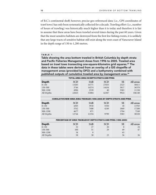
10 overview of bot<strong>to</strong>m trawl<strong>in</strong>gof B.C.’s cont<strong>in</strong>ental shelf; however, precise geo-referenced data (i.e., GPS coord<strong>in</strong>ates oftrawl <strong>to</strong>ws) has only been systematically collected for a decade. <strong>Trawl<strong>in</strong>g</strong> effort (i.e., numberof hours of trawl<strong>in</strong>g) was his<strong>to</strong>rically much higher th<strong>an</strong> it is <strong>to</strong>day <strong>an</strong>d therefore it is fair<strong>to</strong> assume that these areas have been trawled several times dur<strong>in</strong>g the past 60 years. Giventhat the most sensitive habitats are destroyed from the first few fish<strong>in</strong>g events, it is unlikelythat <strong>an</strong>y large tracts of sensitive habitat still exist along the west coast of V<strong>an</strong>couver Isl<strong>an</strong>d<strong>in</strong> the depth r<strong>an</strong>ge of 150 <strong>to</strong> 1,200 metres.TABLE 1Table show<strong>in</strong>g the area bot<strong>to</strong>m trawled <strong>in</strong> British Columbia by depth strata<strong>an</strong>d Pacific Fisheries M<strong>an</strong>agement Areas from 1996 <strong>to</strong> 2005. Trawled areabased on trawl <strong>to</strong>ws tr<strong>an</strong>sect<strong>in</strong>g one-square-kilometre grid squares. 25 Thedata <strong>in</strong> these tables were derived from <strong>an</strong> overlay of a GIS shapefile ofm<strong>an</strong>agement areas (provided by DFO) <strong>an</strong>d a bathymetry comb<strong>in</strong>ed withpublished outputs of cumulative trawled area by m<strong>an</strong>agement area. 26TOTAL AREA (KM2) IN DEPTH STRATA AND PFMADepth 3CD 5AB 5CD 5E All areas0-150 13283 14771 27833 2523 58411150-500 3746 14574 14434 3817 36570500-1200 4996 2539 40 3583 11158All Depths 22025 31884 42307 9924 106140cumulative new area (KM2) trawled (1996-2005) by Depth strata <strong>an</strong>d pfmaDepth 3CD 5AB 5CD 5E All areas0-150 4305 3918 5550 10 13783150-500 3762 7408 4249 1869 17288500-1200 4677 871 1704 7249All Depths 12744 12194 9799 3583 38320percentage of area trawled by depth strata <strong>an</strong>d PFMA (1996-2005)Depth 3CD 5AB 5CD 5E All areas0-150 32 27 20 0 24150-500 100 51 29 49 47500-1200 34 0 65All Depths 58 38 23 36 36