NOAA #12230: Crisfield - Smith Island (p.13-14), etc.
NOAA #12230: Crisfield - Smith Island (p.13-14), etc.
NOAA #12230: Crisfield - Smith Island (p.13-14), etc.
- No tags were found...

Create successful ePaper yourself
Turn your PDF publications into a flip-book with our unique Google optimized e-Paper software.
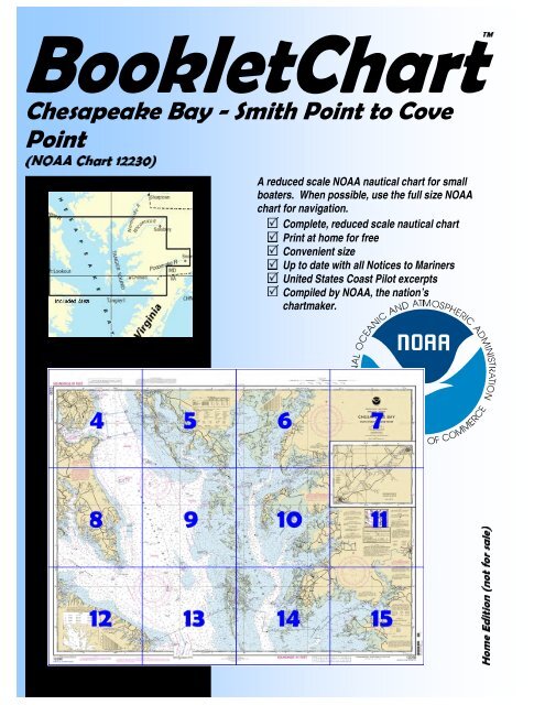
itioneEdHomBookletChartChesapeake Bay - <strong>Smith</strong> Point to CovePoint(<strong>NOAA</strong> Chart 12230)A reduced scale <strong>NOAA</strong> nautical chart for smallboaters. When possible, use the full size <strong>NOAA</strong>chart for navigation.Complete, reduced scale nautical chartPrint at home for freeConvenient sizeUp to date with all Notices to MarinersUnited States Coast Pilot excer ptsCompiled by <strong>NOAA</strong>, the nation’schartmaker.sale)forton(
Published byNational Oceanic and Atmospheric AdministrationNational Ocean ServiceOffice of Coast Surveywww.NauticalCharts.noaa.gov301-713-2770What are Nautical Charts?Nautical charts are a fundamental tool of marine navigation. Theyshow water depths, obstructions, buoys, other aids to navigation, andmuch more. The information is shown in a way that promotes safe andefficient navigation. Chart carriage is mandatory on the commercialships that carry America’s commerce. They are also used on every Navyand Coast Guard ship, fishing and passenger vessels, and are widelycarried by recreational boaters.What is a BookletChart ?This BookletChart is made to help recreational boaters locatethemselves on the water. It has been reduced in scale for convenience,but otherwise contains all the information of the full-scale nautical chart.The bar scales have also been reduced, and are accurate when used tomeasure distances in this BookletChart. Whenever possible, use theofficial, full scale <strong>NOAA</strong> nautical chart for navigation. Nautical chartsales agents are listed at: http://www.NauticalCharts.noaa.gov.The charts and bar scales in this BookletChart have been reduced to75% of original scale, and are printed at the new scale of 1:106,667.This BookletChart does NOT fulfill chart carriage requirements forregulated commercial vessels under Titles 33 and 44 of the Code ofFederal Regulations.Notice to Mariners Correction StatusThis BookletChart has been updated for chart corrections publishedin the U.S. Coast Guard Local Notice to Mariners, the NationalGeospatial Intelligence Agency (formerly NIMA) Weekly Notice toMariners, and, where applicable, the Canadian Coast Guard Notice toMariners. Additional chart corrections have been made by <strong>NOAA</strong> inadvance of their publication in a Notice to Mariners. The last Notices toMariners applied were:Coast Guard Local Notice to Mariners: 28/05 dated July 12, 2005NGA Weekly Notice to Mariners: 29/05 dated July 16, 2005Canadian Coast Guard Notice to Mariners: Not Applicable[Coat Pilot 3, Chapter <strong>14</strong> excerpts](48) Pocomoke River flows into thenortheast end of the Pocomoke Sound 15.5miles above Pocomoke Sound Light 6. Theriver has traffic in petroleum products, sandand gravel, pulpwood, and some fishproducts. The marked approach throughPocomoke Sound has natural depths of 7feet or more for 12.5 miles above thesouthern entrance, then the route passesthrough a marked dredged cut to the mouthof Pocomoke River. In June 2000, thecontrolling depth in the dredged section was 1.7 feet (4.9 feet atmidchannel). The cut is subject to continual shoaling, and lesser depthsmay be found, particularly on the southerly side of the channel.2(49) Pocomoke River has depths of 7 feet or more from the mouth for <strong>14</strong>miles to Pocomoke City, thence 5 feet or more for 12 miles to Snow Hill.Navigation is easy for 20 miles, but the remainder of the channel to SnowHill is narrow and requires local knowledge to carry the best water. Themean range of tide is 2.4 feet at Shelltown and 1.6 feet at Pocomoke City,but is considerably affected by winds. Freshets cause a rise of 1 to 5 feetat Snow Hill, but are not dangerous. The water is fresh above Rehobeth,7.5 miles above the mouth.(50) Shelltown is a village on the west bank of Pocomoke River 1 mileabove the mouth. Gasoline, diesel fuel, and some supplies can beobtained in the village. Marine railways at Shelltown can handle craft upto 40 feet long.(51) Pocomoke City, on the east bank <strong>14</strong> miles above the mouth, has busand rail communication, and all kinds of supplies. There are publiclandings at the highway bascule bridge. Electricity, water, and pumpoutfacilities are available. The railroad bridge over the river at PocomokeCity has a swing span with a clearance of 4 feet; the best water is in thewestern opening.) The overhead power cables 0.3 mile below the bridgehave a clearance of 57 feet. The highway bridge 0.5 mile above therailroad bridge has a bascule span with a clearance of 3 feet. The fixedhighway bridge 1 mile above the railroad bridge has a clearance of 35feet.(52) A dredged channel about 22 miles above the mouth of PocomokeRiver leads southerly from the river to Shad Landing State Park; StatePark, Shad Landing 12230 a marina and turning basin are at the head ofthe channel. In January 1983, the midchannel controlling depth was 4 feetin the channel, and depths of 6 to 7 feet were in the basin. The channel ismarked by a light and a daybeacon. Gasoline and some supplies areavailable.(53) Snow Hill, the town on the east bank 26 miles above the mouth, hasrail freight service. The highway bridge just above the wharves has a 40-foot bascule span with a clearance of 2 feet. An overhead power cablejust above the bridge has a clearance of 61 feet. The river is navigable for2 miles above the bridge. Gasoline and some supplies are available in thetown.(54) A line of marshy islands and flats, with Tangier <strong>Island</strong> at the southend, separates Tangier Sound from Chesapeake Bay to the westward; theprincipal thorofares between the islands are Kedges and Hooper Straits.(58) Tangier Sound, its main entrance 1 mile northeastward of TangierSound Light, affords a broad and deep channel extending the 28-milelength of the sound. Extensive flats border the sound, but the criticalpoints are marked by lights and buoys.(59) The town of Tangier can be reached from either Chesapeake Bay orTangier Sound through well-marked dredged channels. In January 2001,the controlling depths were 6.1 feet (6.5 feet at midchannel) fromChesapeake Bay and 6.0 feet (7.3 feet at midchannel) from TangierSound; a depth of 7.0 feet was in the anchorage basin at Tangier withlesser depths along the N and S edges.(60) (Note that the numbering system of marking the aids to navigationin the channel from Chesapeake Bay to Tangier Sound and from TangierSound to Chesapeake Bay is not continuous but changes in about37°49'54"N., 75°59'49"W.) (61) An overhead power cable with aclearance of 50 feet crosses the channel at Tangier. Gasoline, diesel fuel,and some marine supplies are available at Tangier; a marine railway herecan handle craft up to 50 feet for hull and engine repairs.(62) The flats between Tangier <strong>Island</strong> and <strong>Smith</strong> <strong>Island</strong>, on the north, areshallow and can be navigated only by very small boats at high water.AnchoringTo anchor, bring the bow into the wind orcurrent and put the engine in neutral. When thevessel comes to a stop, lower, do not throw, theanchor over the bow. The anchor line should be5 to 7 times the depth of the water. Do notanchor by the stern.
UPPEMERGENCY INFORMATIONUVHF Marine Radio channels for use on the waterways:Channel 6 – Intership safety communications.Channel 9 – Communications between boats andship-to-coast.Channel 13 – Navigation purposes at bridges, locks,harbors.Channel 16 – Emergency, distress and safety callsto Coast Guard and others, and to initiate calls to othervessels. Contact the other vessel, agree to anotherchannel, and then switch.Channel 22 – Calls between the Coast Guard and thepublic. Severe weather warnings, hazards tonavigation and safety warnings are broadcast here.Channels 68, 69, 71, 72 & 78 – Recreational boatchannels.UDistress Call Procedures1. Make sure radio is on.2. Select Channel 16.3. Press/Hold the transmit button.4. Clearly say: “MAYDAY, MAYDAY, MAYDAY.”5. Also give: Vessel Name and/or Description; Positionand/or Location; Nature of Emergency; Number ofPeople on Board.6. Release transmit button.7. Wait for 10 seconds – If no response RepeatMAYDAY Call.HAVE ALL PERSONS PUT ON LIFE JACKETS !!UMobile – Call PhonesU 911 for water rescue.Coast Guard Search & Rescue – 800-418-73<strong>14</strong>/ 410-576-2525Coast Guard <strong>Crisfield</strong> – 410-968-0323Coast Guard Milford Haven – 804-725-2125/3732Coast Guard Portsmouth – 757-483-8526/8527St.Inigoes – 301-872-4344/4345Maryland Natural Resources Police – 410-260-8888Virginia Marine Police – 800-541-4646U<strong>NOAA</strong> Weather – 162.400 MHz, 162.425 MHz,RadioU162.450 MHz, 162.475 MHz, 162.500 MHz, 162.525 MHz,162.550 MHz.UGetting HelpU and Giving – Signal other boaters using visualdistress signals (flares, orange flag, lights, arm signals);whistles; horns; and on your VHF radio. You are required bylaw to help boaters in trouble. Respond to distress signals, butdo not endanger yourself..<strong>NOAA</strong> CHARTING PUBLICATIONSOfficial <strong>NOAA</strong> Nautical Charts – <strong>NOAA</strong> surveys and charts thenational and territorial waters of the U.S, including the Great Lakes,producing over 1,000 traditional nautical charts covering 3.4 millionsquare nautical miles. Carriage of official <strong>NOAA</strong> charts is mandatory onthe commercial ships that carry our commerce. They are used on everyNavy and Coast Guard ship, fishing and passenger vessels, and arewidely carried by recreational boaters. <strong>NOAA</strong> charts are available fromofficial chart agents listed at: TUwww.NauticalCharts.<strong>NOAA</strong>.gov UT.POfficial Electronic Navigational (ENCs) – ENCs areChartsPdigital files of each chart’s features and their attributes for use incomputer-based navigation systems. ENCs comply with standards of theInternational Hydrographic Organization. ENCs and their updates areavailable for free from <strong>NOAA</strong> at: TUwww.NauticalCharts.<strong>NOAA</strong>.gov UT.Official Raster Navigational Charts (RNCs) – RNCs aregeoreferenced digital pictures of <strong>NOAA</strong>’s charts that are suitable for usein computer-based navigation systems. RNCs comply with standards ofthe International Hydrographic Organization. RNCs and their updatesare available for free from <strong>NOAA</strong> at: TUwww.NauticalCharts.<strong>NOAA</strong>. gov UT.Official BookletCharts - BookletCharts are reduced scale<strong>NOAA</strong> charts printed in page-sized pieces. The “home edition” can bedownloaded from <strong>NOAA</strong> for free and printed. The “professionaledition”, containing additional boating, safety, and educational edition isavailable for <strong>NOAA</strong> chart agents or over the Internet.Official PocketCharts – PocketCharts are for beginningrecreational boaters to use for planning and locating, but not for realnavigation. Measuring a convenient 13” by 19”, they have a 1/3 scalechart on one side, and safety, boating, and educational information on thereverse. They can be purchased at retail outlets and on the Internet.®Official U.S. Coast Pilot – The Coast Pilots are 9 text volumescontaining information important to navigators such as channeldescriptions, port facilities, anchorages, bridge and cable clearances,currents, prominent features, weather, dangers, and Federal Regulations.They supplement the charts and are available from official <strong>NOAA</strong> chartagents or downloaded for free at: TUwww.NauticalCharts.<strong>NOAA</strong>.govUT.Official Print-on-Demand Nautical Charts – These full-scale<strong>NOAA</strong> charts are updated each week by <strong>NOAA</strong> for all Notice to Marinercorrections. They have additional information added in the margin tosupplement the chart. Print on Demand charts meet all federal chartcarriage regulations for charts and updating. Produced under apublic/private partnership between <strong>NOAA</strong> and OceanGrafix, LLC,suppliers of these premium charts are listed at TUwww.OceanGrafix. comUT.®Official Chart No. 1, Nautical Chart Symbols – This referencepublication depicts basic chart elements and explains nautical chartsymbols and abbreviations. Download it for free at:TUwww.NauticalCharts.<strong>NOAA</strong>.govUT.Coast Survey Navigation Manag ers – These ambassadors to themaritime community maintain a regional presence for <strong>NOAA</strong> and helpidentify the challenges facing marine transportation and boating. Theyare listed at TUhttp://nauticalcharts.noaa.gov/nsd/reps.htmUT.Internet TU si www.NauticalCharts.<strong>NOAA</strong>.govUT TUtes: , www.<strong>NOAA</strong>.govUT,TUwww.TidesandCurrents.<strong>NOAA</strong>.govUT, TUwww.NOS.<strong>NOAA</strong>.govUT.<strong>NOAA</strong>, the Nation’s Chartmaker