activities report 3 months ended 31 december 2007 - UraniumSA
activities report 3 months ended 31 december 2007 - UraniumSA
activities report 3 months ended 31 december 2007 - UraniumSA
Create successful ePaper yourself
Turn your PDF publications into a flip-book with our unique Google optimized e-Paper software.
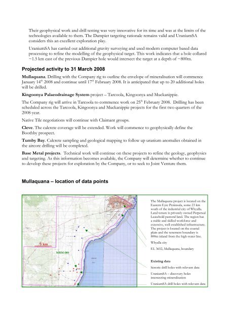
Their geophysical work and drill testing was very innovative for its time and was at the limits of thetechnologies available to them. The Dampier targeting rationale remains valid and <strong>UraniumSA</strong>considers this an excellent exploration play.<strong>UraniumSA</strong> has carried out additional gravity surveying and used modern computer based dataprocessing to refine the modelling of the geophysical target. This work indicates that a hole collared~1.5 km east of the previous Dampier hole would intersect the target at a depth of ~800m.Projected activity to <strong>31</strong> March 2008Mullaquana. Drilling with the Company rig to outline the envelope of mineralisation will commenceJanuary 14 th 2008 and continue until 17 th February 2008. It is anticipated that up to 20 additional holeswill be drilled.Kingoonya Palaeodrainage System project – Tarcoola, Kingoonya and Muckanippie.The Company rig will arrive in Tarcoola to commence work on 25 th February 2008. Drilling has beenscheduled across the Tarcoola, Kingoonya and Muckanippie projects for the first two quarters of the2008-year.Native Tile negotiations will continue with Claimant groups.Cleve. The calcrete coverage will be ext<strong>ended</strong>. Work will commence to geophysically define theBoothby prospect.Tumby Bay. Calcrete sampling and geological mapping to follow up uranium anomalies obtained inthe aircore drilling will be completed.Base Metal projects. Technical work will continue on these projects to refine the geology, geophysicsand targeting. As this information becomes available, the Company will determine whether to continueto develop these projects for exploration by the Company, or to seek to Joint Venture them.Mullaquana – location of data points5 km5kMRM-001The Mullaquana project is located on theEastern Eyre Peninsula, some 23 kmsouth of the industrial city of Whyalla.Land tenure is privately owned PerpetualLeasehold pastoral land. The region hasa stable and skilled workforce andextensive, well established infrastructure.The project is located on the coastalplain and the tenement boundary is800m inland from the high-water line.Whyalla cityEL 3652, Mullaquana, boundaryExisting datahistoric drill holes with relevant data<strong>UraniumSA</strong> – discovery holesintersecting mineralisation<strong>UraniumSA</strong> drill holes with relevant data


