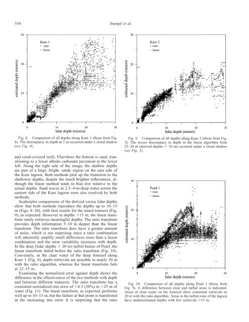
554 Stumpf et al.Fig. 8. Comparison of all depths along Kure 1 (those from Fig.4). The discrepancy in depth at 5 m occurred under a cloud shadow(see Fig. 4).and coral-covered reefs. Elsewhere the bottom is sand, transitioningto a lower albedo carbonate pavement in the lowerleft. Along the right side of the image, the shallow depthsare part of a large, bright, sandy region on the east side ofthe Kure lagoon. Both methods pick up the transition to theshallower depths, despite the much brighter reflectances, althoughthe linear method tends to bias low relative to theactual depths. Sand waves in 2.5–4-m-deep water across theeastern side of the Kure lagoon were also resolved by bothmethods.Scatterplot comparisons of the derived versus lidar depthsshow that both methods reproduce the depths up to 10–15m (Figs. 8–10), with best results for the tuned transect (Fig.9), as expected. However in depths 15 m, the linear transformrarely retrieves meaningful depths. The ratio transformprovides depth information 5–10 m deeper than the lineartransform. The ratio transform does have a greater amountof noise, which is not surprising since a ratio combinationwill inherently amplify small differences more than a linearcombination and the error variability increases with depth.In the deep (lidar depths 20 m) turbid basins of Pearl, thelinear transform failed before the ratio transform (Fig. 10).Conversely, in the clear water of the deep forereef alongKure 1 (Fig. 8), depth retrievals are possible to nearly 30 mwith the ratio algorithm, whereas the linear transform failsat 12–15 m.Examining the normalized error against depth shows thedifference in the effectiveness of the two methods with depthand between different transects. The ratio transform has aconsistent normalized rms error of 0.3 (30%) in 25 m ofwater (Fig. 11). The linear transform, as expected, performswell up to 10–15 m, but the failure at that point is manifestedin the increasing rms error. It is surprising that the ratioFig. 9. Comparison of all depths along Kure 2 (those from Fig.3). The severe discrepancy in depth in the linear algorithm from25–30 m (derived depths 10 m) occurred under a cloud shadow(see Fig. 3).Fig. 10. Comparison of all depths along Pearl 1 (those fromFig. 5). A difference between clear and turbid areas is indicated.Areas of clear water on the forereef show consistent retrievals to20 m with the ratio algorithm. Areas in the turbid zone of the lagoonhave underestimated depths with few retrievals 15 m.
Satellite-derived water depth555Fig. 11. Normalized root mean square (rms) error (ratio of rmserror to actual depth) in 2.5-m bins for (A) Kure 1, (B) Kure 2, and(C) Pearl. The bin at 2.5 m depth was dropped because the normalizationwas problematic for both algorithms with water 0.6 m.transform performed as well as the linear transform alongKure 2 in waters 15 m depth because the linear transformwas tuned to the very lidar data being used for the errorevaluation, whereas the ratio transform was tuned to only afew, independent nautical chart soundings. To investigate thestability of tuning methods, the linear transform was tunedto lidar for the Kure 1 transect. This tuning produced poorresults, with normalized rms errors 0.5 when applied toKure 2.DiscussionThe ratio transform method addresses several issues thathave considerable relevance to using passive multispectralimagery to map shallow-water bathymetry. First, it does notrequire subtraction of dark water, which expands the numberof benthic habitats over which it can be applied. Second, theratio transform method has fewer empirical coefficients requiredfor the solution, which makes the method easier touse and more stable over broader geographic areas. Third,the ratio method can be tuned using available (reliable)soundings. And finally, the results shown here demonstratethat the ratio method has superior depth penetration to thelinear method for a Pacific <strong>Ocean</strong> region with relatively clearwater. The ratio transform has limitations relative to the lineartransform, particularly in an increased level of noise.Our first use of IKONOS imagery (Baker Island in thecentral Pacific) showed shallow-water areas that had lowerreflectance than deep water, so the linear transform could notbe implemented. Although Kure and Pearl do not have shallow-waterareas that are less reflective than deep water (typicallycaused by extremely dense algae or seagrass cover),we have found patches of algae of 1 km 2 within the northwesternHawaiian island chain that have a reflectance darkerthan deep water. Solutions for the linear transform to solvethe low-albedo issue have been proposed (Van Hengel andSpitzer 1991) but require tuning of the patch as well, whichonly increases the number of required coefficients. The standardlinear method requires five coefficients that vary withenvironmental conditions: R ( i ), R ( j ), a 0 ,a i , and a j , whereasthe ratio method requires only two: m 0 and m 1 . As a result,the ratio solution is simple to execute, since tuning can beachieved with a handful of accurate soundings. This is nota trivial issue when working in areas where few soundingsare available.The determination of R probably introduces more uncertaintyin the linear algorithm than any other coefficient. Withany variation in scattering, R will change in both bands,and with variations in absorption, R will change in the blueband. This is extremely difficult to determine locally and caneasily vary throughout a scene. Failure to correctly determineR will affect the depth determination for deeper water.New optimization methods that have been proposed for hyperspectralinstrumentation might resolve this by solving forR (Lee et al. 1999). Such methods could be useful for geographicallylarge mapping projects when hyperspectral imagerybecomes routinely available with standard processing.The ratio transform requires only bands with different waterabsorption and so might be applied to any sensor detectingthe appropriate wavelengths.In addition to applying the ratio transform method to morePacific <strong>Ocean</strong> atolls, we plan to investigate ways of improvingthe current algorithm, in particular to examine methodsfor addressing moderate turbidity. The linear algorithm hasan inherent solution for albedo, which must also be examinedfor the ratio algorithm. The simple tuning, stable results,and superior depth penetration argue for application of theratio algorithm for mapping water depths in extensive coralreef environments similar to those found in this study.ReferencesCHAVEZ, P. S. 1996. Image-based atmospheric corrections—revisitedand improved. Photogramm. Eng. Remote Sens. 62: 1025–1035.GORDON, H. R., D. K. CLARK, J.W.BROWN, O.B.BROWN, R.H.EVANS, <strong>AND</strong> W. W. BROENKOW. 1983. Phytoplankton pigment


![Franz ocrt_terra_franz.ppt [Read-Only] - Ocean Color - NASA](https://img.yumpu.com/24076593/1/190x146/franz-ocrt-terra-franzppt-read-only-ocean-color-nasa.jpg?quality=85)