CLIMATE CHANGE ON MARS INFERRED FROM EROSION RATES ...
CLIMATE CHANGE ON MARS INFERRED FROM EROSION RATES ...
CLIMATE CHANGE ON MARS INFERRED FROM EROSION RATES ...

Create successful ePaper yourself
Turn your PDF publications into a flip-book with our unique Google optimized e-Paper software.
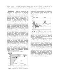
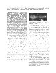
<strong>CLIMATE</strong> <strong>CHANGE</strong> <strong>ON</strong> <strong>MARS</strong> <strong>INFERRED</strong> <strong>FROM</strong> EROSI<strong>ON</strong> <strong>RATES</strong> AT THE <strong>MARS</strong> PATHFINDERLANDING SITE. M. P. Golombek and N. T. Bridges, Jet Propulsion Laboratory, Pasadena, CA 91109Introduction: The observation that the MarsPathfinder landing site probably looks very similar towhen it was deposited by catastrophic floods some 1.8-3.5Ga [1, 2] allows quantitative constraints to be placed onthe rate of change at the landing site since that time.When combined with interpretations of data recentlyreturned by the Mars Pathfinder and Global Surveyormissions and perspectives drawn from 20 years ofanalysis and interpretation of Viking data, theseobservations and inferences suggest an early warmer andwetter environment with vastly different erosion rates anda major climatic change on Mars.Landing Site: Remote sensing data generally at ascale greater than ~1 km and an Earth analog correctlypredicted the Pathfinder site would be a rocky plaincomposed of materials deposited by catastrophic floods[1]. The surface is composed of subangular to subroundedpebbles, cobbles, and boulders, and generally resembles asurface produced by catastrophic floods, such as theEphrata Fan in the Channeled Scabland of WashingtonState [1]. From the lander, the Twin Peaks look likestreamlined islands and rocks in the Rock Garden may beimbricated or inclined blocks generally tilted in thedirection of flow [2]. The general similarity to analogoussurfaces on Earth as suggested in orbiter remote sensingdata argue that the site has undergone minor alteration [3]since it formed in Late Hesperian/Early Amazonian time[4] (estimated to be 1.8-3.5 Ga [5]).Aeolian Features and Environment: The abundanceof erosional features such as an exhumed former soilhorizon, sculpted wind tails, duneforms and other ripplelikelag deposits, and ventifacts all suggest the site hasundergone net deflation or loss of material [2, 6]. A 5-7cm thick redder band along the base of several rocksappears to be a former soil horizon that has been deflatedor exhumed. The sculpted shape of numerous wind tailsbehind rocks and pebbles also suggests they arepredominantly erosional as opposed to the bulbous shapeexpected of wind tails formed by deposition [6]. Ripplelikepebble features at the site and at least some of thedunes, such as Mermaid Dune, are interpreted to be lagdeposits [7] indicative of net erosion or deflation of thelanding site. The presence of ventifacts, or fluted andgrooved rocks also argues for erosion by saltatingcrystalline sand-size particles entrained in the wind [8].All of these features suggest that the landing area hasbeen dominantly scoured by the winds and thus is a zoneof net deflation or erosion and removal of surface fines.In contrast, aeolian depositional features at thePathfinder site are limited to a few duneforms, including abarcan-shaped feature [6] that likely resulted fromredistribution of predominantly locally derived sand-sizematerial. The ventifacts probably formed soon after thecatastrophic flood, which likely introduced a large, freshsupply of sand-size particles distributed across the rockyplain. The orientation of the ventifacts, northeastsouthwestoriented dunes within Big Crater, and possiblyeroded northwest sector of small crater rims all suggestthe strongest winds were oriented southeast-northwestduring this time [8, 9]. Later strong winds from thenortheast to the southwest, completed the deflation of thesurface, deposited sand-size material in dunes andultimately trapped these dunes in lows.Deflation Rates: The inferred depth of deflation at thesite can be used to estimate the deflation rates since thesurface formed some 1.8-3.5 Ga, which provides anestimate of the efficiency of erosional processes on Marsin Amazonian time. The 5-7 cm thick deflated soilhorizon and the 3 cm thick wind tails suggest extremelylow (0.01-0.04 nm/yr) deflation rates. Crater rim heightsseen from the lander are similar to those expected for freshMartian craters, placing similar, albeit less preciseconstraints on erosion rates. Big and Little craters in viewof the lander have rim heights of 40 m and 5.2 m,respectively, which are similar to the expected heights (56m and 6 m) for fresh Martian craters with diameters of 1.5km and 0.15 km [10]. The differences between themeasured and expected heights of these craters are notstatistically distinct [10], so there may have been noerosion of their rims. If the craters are not significantlyyounger than the surface, this limits erosion at thePathfinder site to
EROSI<strong>ON</strong> <strong>RATES</strong>/<strong>CLIMATE</strong> <strong>CHANGE</strong> <strong>ON</strong> <strong>MARS</strong>: M. Golombek and N. BridgesEarly Warmer/Wetter Environment: In contrast tothe desiccating environment of today, a variety ofobservations by Pathfinder support an earlier climate thatwas warmer and wetter. Rounded pebbles and cobbles[7], evidence for abundant sand-size particles [6], andpossible conglomerates [7] observed at the Pathfinderlanding site suggest an early fluvial environment that waswarmer and wetter than today, perhaps with liquid waterin equilibrium with the environment. Airborne dustparticles collected by the Pathfinder magnetic targetsfurther support this hypothesis [12]. The particles arecomposite silicates with a highly magnetic mineralpreferentially interpreted to be maghemite that may havefreeze dried as a stain or cement from liquid water thatpreviously leached iron from crustal materials in an activehydrologic cycle. Trapped dunes, likely composed of sandsize particles, are found at the Pathfinder landing site andappear abundant elsewhere on Mars both at the scale ofViking and Global Surveyor images [13]. Sand on Earthtypically forms via fluvial processes that mechanicallybreak down rocks into smaller fragments [14], which maybe another indicator of a warmer and wetter past. Thesuggestion that the early Martian environment waswarmer and wetter is not new [e.g., 15]. Valley networks(at least one of which, has a central fluvial channel formedby running water in high resolution MOC images) andassociated dry lake beds [15], possible strand lines,beaches and terraces inferring a northern ocean [16], andrimless, degraded craters in ancient heavily crateredterrain [17, 18] have all been described in Viking Orbiterimages and used to argue for a warmer and wetter past inwhich liquid water was stable with the environment.Erosion rates calculated from changes in Noachian agecrater number and shape are 3-5 orders of magnitudehigher (0.1-10 micron/yr) [17, 19] than those calculatedfor more recent times abd are comparable to slowlyeroding environments on Earth.Martian Surface Layer: Our knowledge of theMartian surface layer developed from remote sensingobservations, image analysis and observations at the threelanding sites agrees with the very slow erosion ratesdescribed above and suggest that since the Hesperian asurface layer of order meters to up to several tens ofmeters thick has been redistributed around Mars [20].This layer likely consists of sand and dust size particlesthat are entrained and moved by the wind [21]. Dust canbe deposited and removed at much greater rates over shorttime periods. For example, deposition of dust onPathfinder's solar panels during the 3 month mission hasbeen estimated at roughly 20 mm/yr [22], which cannotrepresent long term averages as such rates would result inmeters thick accumulations of dust within a comparativelyshort span of a million years. Other areas may be net sinksfor aeolian material such as areas like Amazonis Planitia,whose thermal inertia, radar and imaging propertiessuggest an area with meters thick accumulations of dust[20] or the north polar erg, a large region of sand dunessurrounding the polar cap [21]. Other areas such as thePathfinder landing site appear to have been swept clean oreven deflated.Climate Change: Constraints on when the suggestedclimate change occurred are not tightly bound due touncertainties in the proposed crater density time scales[5]. All three landers are on units of Early Amazonian toMiddle Hesperian age and thus document the present daydry, desiccating environment since 3.1-3.7 Ga. ValleyNetworks appear to be dominantly Noachian in age [15],which places them at >3.5-3.8 Ga. The impactdegradation of many valley networks further suggests thatthey may have formed at the tail end of heavybombardment around 3.9 Ga [23].References: [1] Golombek M. et al. (1997) Science,278, 1743-1748. [2] Smith P. H. et al. (1997) Science,278, 1758-1765. [3] Golombek M. et al. (1999) JGR, 104,8523-8553 and 8585-8594. [4] Parker T. J. and Rice J.W. (1997) JGR, 102, 25,641-25,656. [5] Tanaka K. L.(1986) PLPSC 17, JGR, 91, E139-E158. [6] Greeley R. etal. (1999) JGR, 104, 8573-8584. [7] Rover Team (1997)Science, 278, 1765-1768. Moore H. J. et al. (1999) JGR,104, 8729-8746. [8] Bridges N. et al. (1999) JGR, 104,8595-8615. [9] Kuzmin R., and Greeley R. (1999) LPSCXXX, Abstract #1686. [10] Pike R. J. and Davis P. A.(1984) LPS XV, 645-646. [11] Arvidson R. et al. (1979)Nature, 278, 533-535. [12] Hviid S. F. et al. (1997)Science, 278, 1768-1770. Madsen M. B. et al. (1999)JGR, 104, 8761-8779. [13] Breed C. S. et al. (1979) JGR,84, 8183-8204. Malin M. C. et al. (1998) Science, 279,1681-1685. Thomas P. C. et al. (1999) Nature, 397, 592-594. [14] Kuenen P. H. (1960) Sci. Amer. 202, 94-110.Krinsley D. H. and Smalley I. J. (1972) Amer. Sci. 60,286-291. Pettijohn F. J. et al. (1987) Sand and Sandstone,Springer-Verlag, NY. [15] Carr M. H. (1996) Water onMars, Oxford. Malin M. C. and Carr M. H. (1999)Nature, 397, 589-591. [16] Parker T. J. et al. (1993) JGR,98, 11061-11078. [17] Craddock R. A. and Maxwell T.A. (1993) JGR, 98, 3453-3468. Craddock R. A. et al.(1997) JGR, 102, 13321-13340. [18] Barlow N. G. (1995)JGR, 100, 23307-23316. Grant J. A. and Schultz P. H.(1993) JGR, 98, 11025-11042. [19] Carr M. H. (1992)LPSC XXIII, 205-206. Hartmann W. K. et al. (1999)Nature, 397, 586-589. [20] Christensen P. R. and MooreH. J. (1992) Mars, U. Ariz. 686-729. [21] Greeley R. etal. (1992) Mars, U. Ariz. 730-766. [22] Landis G. A. andJenkins P. P. (1998) EOS, 79, F549. [23] Baker V. R. andPartridge J. B. (1986) JGR 91, 3561-3572.