Preliminary Plat Checklist - Highlands County
Preliminary Plat Checklist - Highlands County
Preliminary Plat Checklist - Highlands County

Create successful ePaper yourself
Turn your PDF publications into a flip-book with our unique Google optimized e-Paper software.
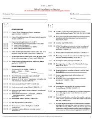
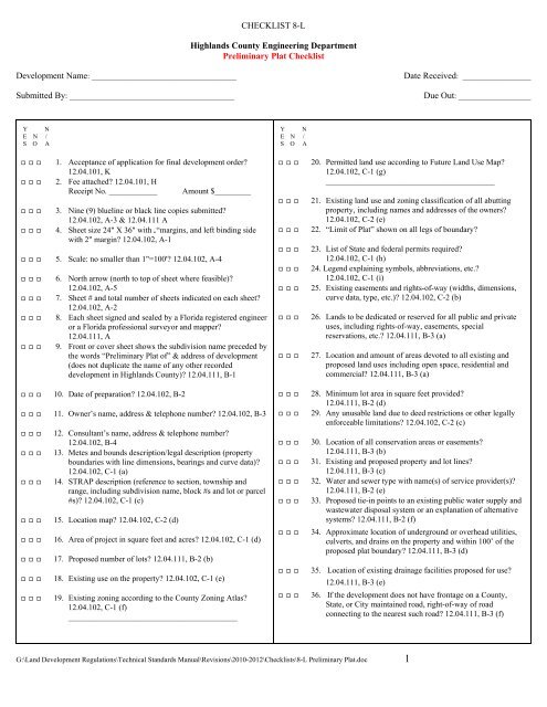
CHECKLIST 8-L<strong>Highlands</strong> <strong>County</strong> Engineering Department<strong>Preliminary</strong> <strong>Plat</strong> <strong>Checklist</strong>Development Name: ____________________________________Submitted By: _________________________________________Date Received: _________________Due Out: __________________Y NE N /S O AE E EE E EE E EE E E1. Acceptance of application for final development order?12.04.101, K2. Fee attached? 12.04.101, HReceipt No. ____________ Amount $_________3. Nine (9) blueline or black line copies submitted?12.04.102, A-3 & 12.04.111 A4. Sheet size 24" X 36" with 2“margins, and left binding sidewith 2" margin? 12.04.102, A-1E E E 5. Scale: no smaller than 1"=100'? 12.04.102, A-4E E EE E EE E EE E E6. North arrow (north to top of sheet where feasible)?12.04.102, A-57. Sheet # and total number of sheets indicated on each sheet?12.04.102, A-28. Each sheet signed and sealed by a Florida registered engineeror a Florida professional surveyor and mapper?12.04.111, A9. Front or cover sheet shows the subdivision name preceded bythe words “<strong>Preliminary</strong> <strong>Plat</strong> of” & address of development(does not duplicate the name of any other recordeddevelopment in <strong>Highlands</strong> <strong>County</strong>)? 12.04.111, B-1E E E 10. Date of preparation? 12.04.102, B-2E E E 11. Owner’s name, address & telephone number? 12.04.102, B-3E E EE E EE E EE E EE E EE E EE E EE E E12. Consultant’s name, address & telephone number?12.04.102, B-413. Metes and bounds description/legal description (propertyboundaries with line dimensions, bearings and curve data)?12.04.102, C-1 (a)14. STRAP description (reference to section, township andrange, including subdivision name, block #s and lot or parcel#s)? 12.04.102, C-1 (c)15. Location map? 12.04.102, C-2 (d)16. Area of project in square feet and acres? 12.04.102, C-1 (d)17. Proposed number of lots? 12.04.111, B-2 (b)18. Existing use on the property? 12.04.102, C-1 (e)19. Existing zoning according to the <strong>County</strong> Zoning Atlas?12.04.102, C-1 (f)__________________________________________Y NE N /S O AE E EE E EE E EE E EE E EE E EE E EE E EE E EE E EE E EE E EE E EE E EE E EE E EE E E20. Permitted land use according to Future Land Use Map?12.04.102, C-1 (g)__________________________________________21. Existing land use and zoning classification of all abuttingproperty, including names and addresses of the owners?12.04.102, C-2 (e)22. “Limit of <strong>Plat</strong>” shown on all legs of boundary?23. List of State and federal permits required?12.04.102, C-1 (h)24. Legend explaining symbols, abbreviations, etc.?12.04.102, C-1 (i)25. Existing easements and rights-of-way (widths, dimensions,curve data, type, etc.)? 12.04.102, C-2 (b)26. Lands to be dedicated or reserved for all public and privateuses, including rights-of-way, easements, specialreservations, etc.? 12.04.111, B-3 (a)27. Location and amount of areas devoted to all existing andproposed land uses including open space, residential andcommercial? 12.04.111, B-3 (a)28. Minimum lot area in square feet provided?12.04.111, B-2 (d)29. Any unusable land due to deed restrictions or other legallyenforceable limitations? 12.04.102, C-2 (c)30. Location of all conservation areas or easements?12.04.111, B-3 (b)31. Existing and proposed property and lot lines?12.04.111, B-3 (c)32. Water and sewer type with name(s) of service provider(s)?12.04.111, B-2 (e)33. Proposed tie-in points to an existing public water supply andwastewater disposal system or an explanation of alternativesystems? 12.04.111, B-2 (f)34. Approximate location of underground or overhead utilities,culverts, and drains on the property and within 100’ of theproposed plat boundary? 12.04.111, B-3 (d)35. Location of existing drainage facilities proposed for use?12.04.111, B-3 (e)36. If the development does not have frontage on a <strong>County</strong>,State, or City maintained road, right-of-way of roadconnecting to the nearest such road? 12.04.111, B-3 (f)G:\Land Development Regulations\Technical Standards Manual\Revisions\2010-2012\<strong>Checklist</strong>s\8-L <strong>Preliminary</strong> <strong>Plat</strong>.doc 1
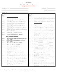
CHECKLIST 8-LY NESNO/AE E E37. Locations and widths of existing and proposed building lines,alleys, parks, other public places, and similar facts aboutadjacent property? 12.04.111, B-3 (g)Y NESNO/AE E E40. Existing surface water bodies, wetlands, streams, and canalswith their seasonal high water elevation and attendantdrainage areas? 12.04.111, B-3 (k)E E E 38. Location of all existing and proposed fire hydrants?12.04.111, B-3 (h)E E E 39. Minimum floor elevation(s) of building(s) within any 100-year floodplain? 12.04.111, B-3 (j)I hereby certify that all of the requirements of this checklist have been adhered to. I also certify that if any of the items on the checklist are notapplicable, I have attached a written explanation as to the reason why the item is not applicable.E E E41. Statement “There are no existing buildings, culverts,easements, boundaries of incorporated areas, lakes, streets,water courses or water mains except as shown or noted. Alllots meet the minimum square footage and road frontageallowed by the current zoning classification.”Specific Requirements:Engineer of Record____________________________________________________________________________________________________________________________________________________________________________________________________________________________________________________________________________________________________________________________________________________________________________________________________________________________________________________________________________________________________________________________________________________________________________________________________________________________________________________________________________________________________________________________________________________________________________________________________________________________________________________________________________________________________________________________________________________________________________________________________________________________________________________________________________________________________________________________________________________________________________________________________________________________________________________________________________________________________________RECOMMENDED FOR:APPROVAL CONDITIONAL APPROVAL REQUEST FOR ADDITIONALINFORMATION___________________________ _______________________________ ____________________________DATE: _____________________ DATE: _________________________ DATE: _____________________DENIAL___________________________DATE: _____________________G:\Land Development Regulations\Technical Standards Manual\Revisions\2010-2012\<strong>Checklist</strong>s\8-L <strong>Preliminary</strong> <strong>Plat</strong>.doc 2