Telescopic Eyeglasses and Model Airplanes
Telescopic Eyeglasses and Model Airplanes
Telescopic Eyeglasses and Model Airplanes

Create successful ePaper yourself
Turn your PDF publications into a flip-book with our unique Google optimized e-Paper software.
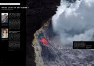
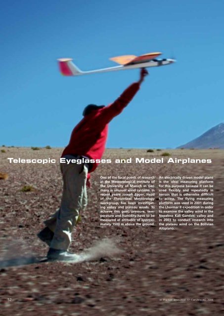
<strong>Telescopic</strong> <strong>Eyeglasses</strong> <strong>and</strong> <strong>Model</strong> <strong>Airplanes</strong>One of the focal points of researchat the Meteorological Institute ofthe University of Munich in Germanyis unusual wind systems. Inrecent years Joseph Egger, Headof the Theoretical Meteorologyworkgroup, has been investigatingvalley <strong>and</strong> plateau winds. Toachieve this goal, pressure, temperature<strong>and</strong> humidity have to bemeasured at altitudes of approximately1500 m above the ground.An electrically driven model planeis the ideal measuring platformfor this purpose because it can beused flexibly <strong>and</strong> repeatedly interrain that is otherwise difficultto access. The flying measuringplatform was used in 2001 duringthe Lhormar II expedition in orderto examine the valley wind in theNepalese Kali G<strong>and</strong>aki valley <strong>and</strong>in 2003 to conduct research intothe plateau wind on the BolivianAltiplano.52In Practice Innovation 17, Carl Zeiss AG, 2006
The Kali 1 flyingmeasuring platformThe “Kali 1” model was designedby the model plane pilot WolfgangSchäper in 2001 for the Lhomar II expedition<strong>and</strong> built by the firm <strong>Model</strong>bauMüller in a total of ten models.Stephan Lämmlein <strong>and</strong> Philip Kolbfrom the German Aero Club were alsoavailable as pilots. During the entiremeasuring campaign, ten of thesemodels, equipped with miniature systems,were used. The model airplanewith a wingspan of 2.1 meters <strong>and</strong> abattery-driven electro-drive, weighed3.1 kilos <strong>and</strong> reached a height of2200 meters above ground. Duringthe flight time of approximately25 minutes, the temperature <strong>and</strong>humidity profiles were measured ata high measuring rate. Stationary,ground-based measuring stations <strong>and</strong>pilot balloon ascents supplementedthe spectrum of measuring methodsused.After the start, the pilot takescontrol of the plane with a rangeoptimizedremote control device.He is supported by a colleague whoconstantly observes the plane witha pair of binoculars. The pilot himselfis equipped with a special visualdevice, a pair of telescopic eyeglassesfrom Carl Zeiss to enable him to alsocontrol the plane safely <strong>and</strong> preciselyat high altitudes.The telescopic eyeglasses werespecially produced for the pilots.They consist of a system with a Keplerdesign <strong>and</strong> feature 3x magnification.The telescope was integratedinto a pair of glasses to ensure thatthe pilots’ h<strong>and</strong>s were free to controlthe model plane <strong>and</strong> observe at thesame time. For the pilots, h<strong>and</strong>lingthe telescopic glasses was a majorchallenge, as the magnification usedclearly changes the visual impressionsconveyed. The model planes observedare imaged with a greater size on theretina <strong>and</strong> the visual system thereforeperceives them as being closer. Movementsinside the field of view are alsogreater due to the magnification factor.This is why microsurgeons, forexample, cannot operate with magnifyingvisual devices until after a considerabletraining period.Left: Helping the Kali 1measuring platform get offthe ground.Center: Kepler-typetelescopic eyeglasses.Right: The entire teamof the Kali G<strong>and</strong>aki expedition:scientists, pilots,bearers <strong>and</strong> kitchen staffin the border area betweenNepal <strong>and</strong> Tibet.In Practice Innovation 17, Carl Zeiss AG, 200653
detailsValley of the Kali G<strong>and</strong>akiThe valley of the Kali G<strong>and</strong>aki features two superlatives:between Kalopani <strong>and</strong> Larjung one finds oneself st<strong>and</strong>ingat the bottom (approx. 2540 meters) of the world’s deepestvalley. Its winds display the most extreme diurnal cycleknown to scientists. The 8167-meter Dhaulagiri in the west<strong>and</strong> the 8091-meter Annapurna in the east are only about35 kilometers apart at this point. This means one is around5500 meters under the mountain peaks.At the breakthrough, the distance between the river bed<strong>and</strong> the peaks is more than 5000 meters. The Kali G<strong>and</strong>akiis one of the four large rivers in Nepal. It rises in Mustangon the border with Tibet <strong>and</strong> flows into the Ganges.At Ghasa, the river rushes downward by a thous<strong>and</strong>meters in a steep canyon <strong>and</strong> finally approaches Nepal’slowl<strong>and</strong>s.The Kali G<strong>and</strong>akiwind systemJoseph Egger <strong>and</strong> his team had setthemselves the goal of investigatingthe unusual wind system in theworld’s deepest valley together withthe model plane pilots WolfgangSchäper, Stephan Lämmlein <strong>and</strong> PhilipKolbe. While a wind with storm forceblows into the valley during the day,the wind leaving the valley at night isweak.Therefore, this wind system is totallydifferent from the wind systemsobserved in large Alpine valleys. Thequestion to be asked was how thisunusual wind system can develop inthe first place.By means of very successful measurements<strong>and</strong> computer simulations,a conclusive explanation was finallyfound for the development mechanismof the Kali G<strong>and</strong>aki winds. Awall separates the Mustang basinfrom the world in the south. A narrowpassage through the wall representsthe valley section from Ghasato Marpha. If the sun shines fromabove, the air in the basin heats upstrongly, <strong>and</strong> that in the forel<strong>and</strong> to alesser degree as there is much greatermass to be heated there. In the gateway,a valley wind then emerges, thespeed of which then increases. Thiswind extends into the posterior partof the basin. In the narrow connectingarea, the winds accelerate <strong>and</strong>reach the basin in the form of stronggusts.54In Practice Innovation 17, Carl Zeiss AG, 2006
TiticacaseeBeniMamoreCopacabanaLa PazDesaquaderoCochabambaThe Altiplanowind systemThe Altiplano in the Andes is thelargest high plateau in the southernhemisphere. Extensive tablel<strong>and</strong>s inthe tropics <strong>and</strong> subtropics display anindependent diurnal air circulation.Due to the strong solar irradiation,the earth’s surface is strongly heatedduring the daytime. The hot groundacts like a hot plate under the atmosphereabove it. The air above theAltiplano is heated to a considerablygreater extent than the surroundingair at the same level above the lowl<strong>and</strong>.This results in pressure gradientswith an area of low pressure abovethe plateau <strong>and</strong> an area of high pressureabove the lowl<strong>and</strong>. From thesegradients of temperature <strong>and</strong> pressure,an extreme wind is producedfrom the lowl<strong>and</strong> to the Altiplano.The AltiplanodetailsThe Altiplano (Puna, Páramo) isa plateau between the high mountainranges of the western <strong>and</strong>eastern Andes. The Altiplano liesat an average altitude of 3600 mabove sea level <strong>and</strong> extends overa surface of about 170,000 km².Lake Titicaca in the north, LakePoopó <strong>and</strong> the Lago Coipasa inthe middle as well as the Salar deUyuni salt lake in the south are themost important stretches of wateron the Altiplano. The climate ofthe Altiplano is cold <strong>and</strong> semi-aridto arid, <strong>and</strong> the average annualtemperatures fluctuate between3 degrees in the western region<strong>and</strong> 12 degrees at Lake Titicaca.OruroPooposeeoposeeAltiplanoPotosiSucrePilayaTarijaVillazonTop: The deep Kali G<strong>and</strong>akivalley channels the windsfrom Nepal toward theTibetan plateau.Center: Philip Kolbnavigates with the Zeisstelescopic eyeglasses whileWolfgang Schäper followsthe model with a pairof binoculars for addedsafety.Right: Initial preparationsagainst the backdrop of the5916 m-high Licancaburson the Altiplano.In Practice Innovation 17, Carl Zeiss AG, 200655
Other researchprojectsThere were also assignments for the“Kali” <strong>and</strong> its team in Germany. InAugust 2005 the Munich meteorologistsmoved close to NeuschwansteinCastle to investigate a wind phenomenonnever experienced before.Flights were also undertaken on theZugspitze mountain in order to studythe emergence <strong>and</strong> dynamics of bannerclouds.Andreas Bürkert from the Universityof Kassel approached WolfgangSchäper with a totally different task: inOman’s Hajar mountains, aerial photoswere to be taken of remote mountainoases. The subject of scientific interesthere was the mapping of field culturesthat were thous<strong>and</strong>s of years old <strong>and</strong>were primarily created in the form ofterraces. From the meteo-plane „Kali“,Schäper developed the photo-plane“Horus” for the installation of a highresolution digital camera. About 20flights were conducted during two expeditionsin the spring <strong>and</strong> fall of2005.“Horus”the photo-planeThe analysis of changes in the conditions<strong>and</strong> processes of agriculturalproduction in Oman’s oasis settlementsis part of an interdisciplinary,humanistic <strong>and</strong> scientific project ofthe workgroup “Ecological CropFarming <strong>and</strong> Research into AgriculturalEcosystems in the Tropics <strong>and</strong>Subtropics” of University of Kasel inGermany. In 2005 a speciallyequipped model plane was used dur-ing two Oman expeditions. Schäper‘stask was to use the “Horus” photoplaneto map the ecosystems usinghigh resolution aerial photos: for thescientific analysis of the systems onthe one h<strong>and</strong> <strong>and</strong> to record thestatus quo on the other. The flights,most lasting a half an hour, tookplace between 1000 <strong>and</strong> 1400meters above the ground. With aboutfour flights a day, several thous<strong>and</strong>pictures were obtained in all. Schäperused the special telescopic eyeglassesfrom Carl Zeiss to control the planesafely <strong>and</strong> precisely at the highaltitudes.Wolfgang Schäper, <strong>Model</strong>lFlugGruppe Markdorfwww. mfg-markdorf.dewww.wiz.uni-kassel.de/ink/www.meteo.physik.uni-muenchen.dewww.zeiss.de56In Practice Innovation 17, Carl Zeiss AG, 2006
QatarUnitedArab EmiratesSuhàrMina al FahlIbrìNizwáMatrahMuscatSurSaudi ArabiaOmanDuqmMasirahdetailsOasis settlements in OmanYemenRaysutThamarìtSalàlahThe Sultanate of Oman lies onthe southern coast of the Arabianpeninsula. For centuries, highlyadvanced agriculture <strong>and</strong> coastalfishing were the livelihood of thepopulation of Oman. The country’sagricultural structure started tochange with the beginning ofcommercial oil production <strong>and</strong>the political opening in theearly 1970s.Top: Aerial photo of theMassirat mountain oasisin Oman.Center: Wolfgang Schäperwith the “Horus” photoplanein Oman’s Hajarmountains.Right: On the dune ofAl Hawiyah.In Practice Innovation 17, Carl Zeiss AG, 200657