- Page 1 and 2:
STEPS TO SUSTAINABLEAND COMMUNITY-B
- Page 3 and 4:
A publication of the NTFP Exchange
- Page 5 and 6:
TABLE OF CONTENTSACKNOWLEDGEMENTSii
- Page 7 and 8:
STEP 7IMPLEMENT AND MONITOR THE MAN
- Page 9 and 10:
A Penan Magoh of Sarawak, Malaysia
- Page 11 and 12: How this manual was writtenThis man
- Page 13 and 14: The Mangyan of Mindoro have a livel
- Page 15 and 16: Box 1. The importance of including
- Page 17 and 18: There is widespread agreement that
- Page 19 and 20: Figure 4. An illustration of the co
- Page 21 and 22: Conducting a participatory rattan i
- Page 23 and 24: STEP 1meaning that any community th
- Page 25 and 26: STEP 11.3.2. Other NTFP stakeholder
- Page 27 and 28: STEP 1Where to next?By the end of S
- Page 29 and 30: STEP 2• Certification requirement
- Page 32 and 33: STEP 2Where to next?By the end of S
- Page 34 and 35: STEP 33.2. When to document the exi
- Page 36 and 37: STEP 3Box 6. Obtaining the scientif
- Page 38 and 39: STEP 33.4.4. NTFP management practi
- Page 40 and 41: STEP 3• Do harvesters use any oth
- Page 42 and 43: STEP 3Box 8. Policies and laws rela
- Page 44 and 45: STEP 4EVALUATE THE EXISTING SYSTEM
- Page 46 and 47: STEP 4Table 2. Ecological predictor
- Page 48 and 49: STEP 4Table 4. Social predictors of
- Page 50 and 51: STEP 44.5. Political predictors of
- Page 52 and 53: STEP 4Ultimately, the community wil
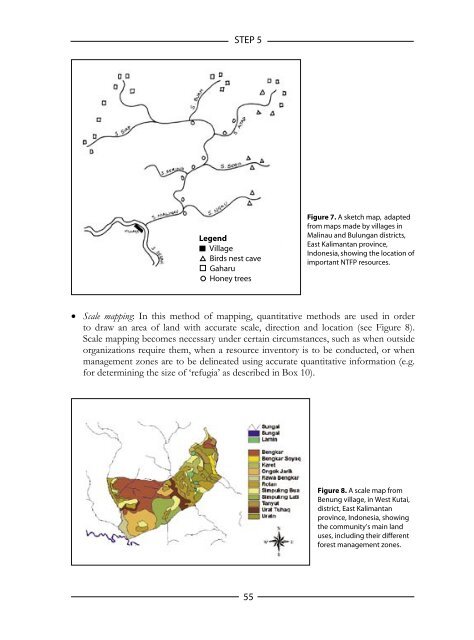
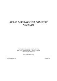
- Page 54 and 55: STEP 5The extent to which new appro
- Page 56 and 57: STEP 55.1.2. NTFP resources that ar
- Page 58 and 59: STEP 55.1.4. A summary of managemen
- Page 60 and 61: STEP 5Rotational: Harvesting is rot
- Page 64 and 65: STEP 5Box 11. Important harvesting
- Page 66 and 67: STEP 55.2.4. Assessing current harv
- Page 68 and 69: STEP 5A low input approachThe only
- Page 70 and 71: STEP 5Box 14. Estimating the popula
- Page 72 and 73: STEP 5seed to harvestable size or o
- Page 74 and 75: STEP 5Box 15. Understanding regener
- Page 76 and 77: STEP 5Example 21. Estimating the su
- Page 78 and 79: STEP 6To develop a management plan,
- Page 80 and 81: STEP 6• Sacred groves or other si
- Page 82 and 83: STEP 6The community should also out
- Page 84 and 85: STEP 6Example 23. The Community Res
- Page 86 and 87: STEP 6NTFP-Task Force members in th
- Page 88 and 89: STEP 66. Results of resource invent
- Page 90 and 91: STEP 6Where to next?By the end of t
- Page 92 and 93: STEP 7Developing a plan for monitor
- Page 94 and 95: STEP 7• Evidence that the decisio
- Page 96 and 97: STEP 7existing management system’
- Page 98 and 99: STEP 7Example 26. Monitoring wildli
- Page 100 and 101: STEP 7• Are there any gaps in kno
- Page 102 and 103: ENDNOTESparticipants get together t
- Page 104 and 105: REFERENCESAlder D. & Synnott T. J.
- Page 106 and 107: REFERENCESDawkins H. C. (1958) The
- Page 108 and 109: REFERENCESMaxwell S. E. & Delaney H
- Page 110 and 111: REFERENCESSchelhas J., Buck L. E. &
- Page 112 and 113:
APPENDIX AHOW TO DELINEATE MANAGEME
- Page 114 and 115:
APPENDIX AA.2.3. Costs of making th
- Page 116 and 117:
APPENDIX AA.3.2. How to make a sket
- Page 118 and 119:
APPENDIX A• Agricultural lands, d
- Page 120 and 121:
APPENDIX AKey ReferencesBelow are k
- Page 122 and 123:
APPENDIX B• Applying adaptive man
- Page 124 and 125:
APPENDIX Boutline how the test will
- Page 126 and 127:
APPENDIX BThe factors of interest c
- Page 128 and 129:
APPENDIX Band vigor of a resource,
- Page 130 and 131:
APPENDIX CHOW TO MAKE HARVEST RECOR
- Page 132 and 133:
APPENDIX CC.2.3. TimeThe time taken
- Page 134 and 135:
APPENDIX C• Examine the progress
- Page 136 and 137:
APPENDIX CResource reproduction:•
- Page 138 and 139:
APPENDIX C• Evidence of leaf and
- Page 140 and 141:
APPENDIX CIt is best if these resul
- Page 142 and 143:
APPENDIX DD.1.3. Key principles inv
- Page 144 and 145:
APPENDIX Dbe three times more expen
- Page 146 and 147:
APPENDIX D• The distance of inter
- Page 148 and 149:
APPENDIX Dto concentrate on the bio
- Page 150 and 151:
APPENDIX EE.1.2. How are resource i
- Page 152 and 153:
APPENDIX EExample E.2. The importan
- Page 154 and 155:
APPENDIX EAn accurate scale map is
- Page 156 and 157:
APPENDIX EPlot size. Small plants a
- Page 158 and 159:
APPENDIX EBox E.2. Different measur
- Page 160 and 161:
APPENDIX E• The resource’s popu
- Page 162 and 163:
APPENDIX FF.2. CostF.2.1. Equipment
- Page 164 and 165:
APPENDIX FAt least five individuals
- Page 166 and 167:
APPENDIX FChoosing what measurement
- Page 168 and 169:
APPENDIX Fand low; or individually-
- Page 170 and 171:
APPENDIX Fclass specific conversion
- Page 172 and 173:
APPENDIX GG.1.3. Key principles inv
- Page 174 and 175:
APPENDIX Gplanned quantitative meth
- Page 176 and 177:
APPENDIX GQuestion 3: Is the plant
- Page 178 and 179:
APPENDIX GAn example of a recovery
- Page 180 and 181:
APPENDIX Gresource population shoul
- Page 182 and 183:
APPENDIX Henables the community to
- Page 184 and 185:
APPENDIX HObjective 2. The resource
- Page 186 and 187:
APPENDIX Hmay need to be monitored
- Page 188 and 189:
APPENDIX IHOW TO STUDY DEMOGRAPHYI.
- Page 190 and 191:
APPENDIX II.2. CostI.2.1. Equipment
- Page 192 and 193:
APPENDIX IFigure I.2. A suitable pl
- Page 194 and 195:
APPENDIX I• Germination tests. Se
- Page 196 and 197:
APPENDIX IKey ReferencesBelow are k
- Page 198:
STEPS TO SUSTAINABLEAND COMMUNITY-B