Aquifer Recharge, Storage, and Recovery - Southwest Hydrology ...
Aquifer Recharge, Storage, and Recovery - Southwest Hydrology ...
Aquifer Recharge, Storage, and Recovery - Southwest Hydrology ...
- No tags were found...

You also want an ePaper? Increase the reach of your titles
YUMPU automatically turns print PDFs into web optimized ePapers that Google loves.
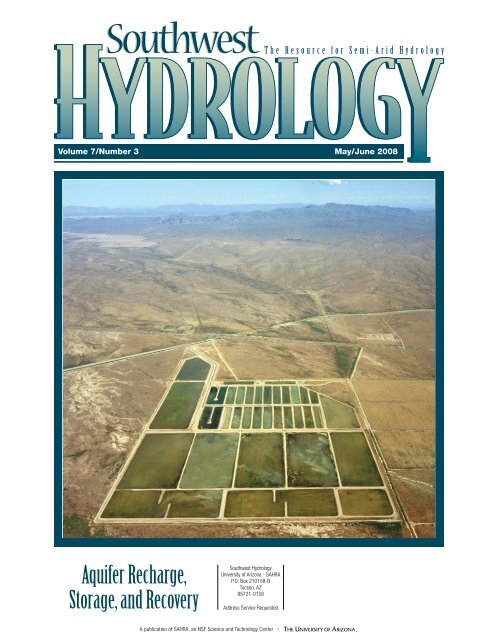
T h e R e s o u r c e f o r S e m i - A r i d H y d r o l o g yVolume 7/Number 3 May/June 2008<strong>Aquifer</strong> <strong>Recharge</strong>,<strong>Storage</strong>, <strong>and</strong> <strong>Recovery</strong><strong>Southwest</strong> <strong>Hydrology</strong>University of Arizona - SAHRAP.O. Box 210158-BTucson, AZ85721-0158Address Service RequestedA publication of SAHRA, an NSF Science <strong>and</strong> Technology Center
A few thoughts about a good team:Joining founding partners(from left) Doug Bartlett <strong>and</strong>Marvin Glotfelty as Principalsof Clear Creek Associatesin Phoenix are:Thomas R. Suriano, R.G., joinedClear Creek in 2006, bringingtwenty-two years of experiencemanaging environmental <strong>and</strong>water resources projects.Donald P. Hanson, R.G., joinedClear Creek in 2000 <strong>and</strong> hastwenty-two years of experiencemanaging environmental <strong>and</strong>water resources projects.Announcing Some New PrincipalsBack in 1999, we assembled our new company on one guiding principle:that the value of our services would equal the sum of our staff.Over the years, our success in growing our small company has been areflection of this principle—such that the scope <strong>and</strong> range of what weprovide is the result of the integrity of our collective professional capabilities.So it is with complete confidence that we are promoting Mike Alter,Don Hanson, <strong>and</strong> Tom Suriano to positions as principal hydrogeologistsat Clear Creek Associates, responsible for technical, contractual, <strong>and</strong>business matters.So, three new principals; one long-st<strong>and</strong>ing principle; <strong>and</strong> a single priority:to provide quality-focused, very responsive, integrated hydrologic services.And in Tucson:Michael L. Alter, R.G., joinedClear Creek Associates at itsinception in 1999 as head of theTucson office <strong>and</strong> brings thirteenyears of experience consultingon environmental <strong>and</strong> waterresources projects.in Phoenix:6155 E. Indian School Rd., Suite 100, Scottsdale, Arizona 85251(480) 659-7131, (480) 659-7134 faxin Tucson:221 N. Court Ave., Suite 101, Tucson, Arizona 85701(520) 622-3222, (520) 622-4040 faxwww.clearcreekassociates.com
Levelogger Proven to beWorth its Weight in GoldJunior ......the newest additionto the LeveloggerFamilyM<strong>and</strong>ate To Deliver QualitySince the Levelogger Gold was launched at the beginning of 2006,Solinst has shipped thous<strong>and</strong>s <strong>and</strong> thous<strong>and</strong>s of units to satisfiedcustomers all over the world."Our m<strong>and</strong>ate is to design <strong>and</strong> deliver high quality products, <strong>and</strong> back it upwith our 3 Year Warranty, demonstrating the Solinst commitment to ourcustomers."— Sarah Belshaw, PresidentDependable Water Level DataloggerMaintenance Free Design/Lifetime CalibrationBackwards Compatible3 Year WarrantyReal-Time ViewUser-selectable Sampling Schedule10 Year Battery (1 reading/minute)SCADA Ready (SDI-12)Reduce Your Bottom LineA low cost alternative in theLevelogger SeriesAccuracy of 0.1% FS32,000 Datapoints5 Year Battery1 Year WarrantyCompatible with LeveloggerGold Series, Software<strong>and</strong> AccessoriesLeveloader GoldThe Levelogger Gold is a self contained water level datalogger, which iscompletely designed, developed <strong>and</strong> manufactured in-house, in the traditionof all Solinst high quality products. The Levelogger Gold uses infra-red datatransfer, providing the flexibility of installing by use of a simple wireline or byusing a Direct Read Cable to surface. The Levelogger Gold includes apressure transducer, temperature thermistor, 10 year lithium battery (basedon 1 reading per minute), <strong>and</strong> internal data logger with a capacity of 40,000temperature <strong>and</strong> water level data points.Rugged Data Transfer DeviceDedicated to Levelogger SeriesStores 1.39 Million DatapointsReal-Time ViewRe-program in the FieldSolinst Canada Ltd., 35 Todd RoadGeorgetown, ON L7G 4R8Tel: +1 (905) 873-2255; (800) 661-2023Fax: +1 (905) 873-1992; (800) 516-9081Website:E-mail:www.solinst.cominstruments@solinst.com
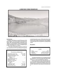
T h e R e s o u r c e f o r S e m i - A r i d H y d r o l o g y<strong>Southwest</strong> <strong>Hydrology</strong>PublisherBetsy WoodhouseTechnical EditorHoward GrahnEditorMary BlackA bimonthly trade magazine for hydrologists, water managers, <strong>and</strong> other professionals working with water issues.Graphic DesignerMike BuffingtonSAHRA Knowledge TransferGary WoodardDoes your region have extra water now that you want to save for later, when there mightbe a drought? You could keep it in a reservoir if you have access to one, but you’ll losesome of the water to evaporation. Or you could let it seep into the ground or inject itdown a well to an aquifer, <strong>and</strong> plan to pump it back out when you need it. Your biggestproblem may be figuring out what to call this process: in preparing this issue, wediscovered strong <strong>and</strong> diverse opinions on terminology, especially among experts. Not allwill agree with our decision (see page 16 sidebar), but we believe “aquifer storage <strong>and</strong>recovery” most clearly describes what we’re talking about.Did you pay someone for your <strong>Southwest</strong> <strong>Hydrology</strong> subscription, or receive it as a“gift”? Say it ain’t so! We recently learned that some unscrupulous entities are offering<strong>Southwest</strong> <strong>Hydrology</strong> subscriptions for around $10/year <strong>and</strong> pocketing the money.<strong>Southwest</strong> <strong>Hydrology</strong> is FREE! We are taking steps to stop this activity; if you paid,please let us know.Thanks to all of you who responded to our online survey, which was sent to the roughly4,300 subscribers for which we have valid email addresses. We received some excellentsuggestions, many of which we hope to implement in future issues, <strong>and</strong> learned a lotabout our readers. We will provide more on the results in the next issue. Bottom line: mostrespondents are quite satisfied with <strong>Southwest</strong> <strong>Hydrology</strong> <strong>and</strong> are also happy in theirjobs. And more than half usually or always read this letter—not just my mother!We thank our newest sponsor of <strong>Southwest</strong> <strong>Hydrology</strong>: Salt River Project. They, alongwith existing sponsors (see page 9) <strong>and</strong> our advertisers, help make continued freepublication possible. We also thank all contributors to this issue.Betsy Woodhouse, PublisherFrom thePublisherThe Vidler <strong>Recharge</strong> Facility, about 90miles west of Phoenix, recharges CentralArizona Project water through some460 acres of infiltration basins. Thewater will be recovered in the futureby Vidler or its buyer, for currentlyundetermined use(s).Cortney C. Br<strong>and</strong>Greg BushnerMark CrossDenise D. FortPeter FoxGerald E. GallowayKenneth GlotzbachContributorsAdvisory BoardDavid Bolin, R.G.Charles Graf, R.G.Jim Holway, Ph.D.Jeff JohnsonDavid Jordan, P.E.Karl Kohlhoff, P.E., B.C.E.E.Stan LeakeAri Michelsen, Ph.DMark Murphy, Ph.D.Peggy RoeferMartin Steinpress, R.G., C.HG.Printed in the USA by CityPressMario R. LluriaSharon B. MegdalAri M. MichelsenChristian E. PetersenTaylor ShipmanCat Shrier<strong>Southwest</strong> <strong>Hydrology</strong> is published six times per year by theNSF Center for Sustainability of semi-Arid <strong>Hydrology</strong> <strong>and</strong>Riparian Areas (SAHRA), College of Engineering, The Universityof Arizona. Copyright 2008 by the Arizona Board of Regents.All rights reserved. Limited copies may be made for internaluse only. Credit must be given to the publisher. Otherwise,no part of this publication may be reproduced without priorwritten permission of the publisher.ISSN 1552-8383SubscriptionsSubscriptions to <strong>Southwest</strong> <strong>Hydrology</strong> are free. To receive themagazine, contact us as shown below.AdvertisingAdvertising rates, sizes, <strong>and</strong> contracts are available atwww.swhydro.arizona.edu. Please direct ad inquiries to usas shown below. Space must be reserved 50 days prior topublication date.Free Job Announcements<strong>Southwest</strong> <strong>Hydrology</strong> will publish job announcements in theEmployment Opportunities section. The first 70 words foreach announcement is free; after that, the charge is $70 peradditional 70 words. To place an ad, contact us as shownbelow. All announcements, of any length, may be posted onour website for no charge (www.swhydro.arizona.edu).Editorial Contribution<strong>Southwest</strong> <strong>Hydrology</strong> welcomes letters <strong>and</strong> contributionsof news, project summaries, product announcements, <strong>and</strong>items for The Calendar. Send submissions by mail or email asshown below. Visit www.swhydro.arizona.edu for additionalguidelines for submissions.Web Sites<strong>Southwest</strong> <strong>Hydrology</strong> - www.swhydro.arizona.eduSAHRA - www.sahra.arizona.eduCONTACT US<strong>Southwest</strong> <strong>Hydrology</strong>, The University of Arizona, SAHRAPO Box 210158-B, Tucson, AZ 85721-0158.Phone 520-626-1805. Email mail@swhydro.arizona.edu. • May/June 2008 • <strong>Southwest</strong> <strong>Hydrology</strong>
[SOUND PRINCIPLE NO. 33]Irrigation CanalsW E M E A S U R E F L O W(in places you never thought possible)Natural StreamsSound Principles. Good Advice.A remarkably simple concept that you can afford.Real-Time DischargeWe underst<strong>and</strong> what it’s like out in the field, because that’s where we got our start.We have made using precision-based acoustic Doppler technology easy to use in eventhe most rugged, <strong>and</strong> challenging conditions.More options, better customer support <strong>and</strong> more value for less money.[+1.858.546.8327]9940 Summers Ridge RoadSan Diego, California, USAFor FREE technical notes, access to web-based training<strong>and</strong> product information, visit www.sontek.com.Questions? E-mail: inquiry@sontek.com.
Inside This IssueDepartments8 On the Ground• WRDA 2007 water policy provisions,by Gerald E. Galloway <strong>and</strong>Ari M. Michelsen• Arizona’s groundwater savingsprogram, by Sharon B. Megdal <strong>and</strong>Taylor Shipman12 Government• Water scarcity <strong>and</strong> growthin Southern California• New Mexico mulls regulationof deep aquifers• New Mexico <strong>and</strong> Texasresolve 29-year dispute• Rio Gr<strong>and</strong>e pits Mexico versusTexas; disagreement heads to Canada• Oil shale projects could impactColorado water• EPA wastewater infrastructureneeds $202 billion• Bromate spike in Los Angelesreservoirs12 HydroFacts34 R&D• Dire predictions for ColoradoRiver reservoirs• Mussel menace update: theyseem to be thriving• Water quality impacts toshallow groundwater• Human activities linked tochanges in water resources• Coachella Valley is sinking atincreasing rates• Extreme precipitation eventslinked to global warming• Integrated energy/water modelin the works41 In PrintDamming Gr<strong>and</strong> Canyon: The 1923USGS Colorado River Expedition,reviewed by Betsy Woodhouse42 Calendar<strong>Aquifer</strong> <strong>Recharge</strong>, <strong>Storage</strong>, <strong>and</strong> <strong>Recovery</strong>In this issue we define the deliberate recharge <strong>and</strong> temporary storage of “excess”(unneeded) water in an aquifer, with the intent of recovering that water for future use,as aquifer storage <strong>and</strong> recovery (ASR). The technique is increasingly being used asa water management tool. The implementation of ASR projects varies widely in thetype of water used, method of recharge, aquifer type, <strong>and</strong> engineering of the project,as described in these feature articles. Furthermore, water quality changes resultingfrom mixing two different waters must be considered, as well as regulatory <strong>and</strong>policy constraints. And do you really get that water back? Read all about it…16 An ASR PrimerCortney C. Br<strong>and</strong>What is aquifer storage <strong>and</strong> recovery?What are its benefits <strong>and</strong> limitations?How does it work? Who is doingit? Comparing a number of ASRprojects in the <strong>Southwest</strong> illustratesthe range of objectives, watersources, aquifer types, <strong>and</strong> recharge<strong>and</strong> recovery methods utilized.18 Hydrogeology <strong>and</strong> ASR DesignGreg BushnerSite hydrology is critical to the successof an ASR project. What factors shouldbe considered in evaluating l<strong>and</strong> <strong>and</strong>water? Which data are needed todetermine site <strong>and</strong> soil suitability <strong>and</strong>ensure nondegradation of water quality?20 ASR <strong>and</strong> the “Big Picture”Cat ShrierA recent National Research Councilreport <strong>and</strong> forum identified institutionalissues that have prevented ASR frombeing more widely accepted. Althoughthe details of any project are local,some actions taken at the federal<strong>and</strong> regional levels could facilitatemore widespread use of aquifersas potential storage zones <strong>and</strong> forconjunctive water management.22 ASR from a Legal PerspectiveDenise D. FortThe regulatory structure for ASR iscomplex because the legal systemhas historically addressed waterquality issues independently of waterquantity, as it has groundwater <strong>and</strong>surface waters. Authority over aproject may also be divided betweenfederal <strong>and</strong> state governments.Publishing <strong>Southwest</strong> <strong>Hydrology</strong> furthers SAHRA’smission of promoting sustainable managementof water resources in semi-arid regions.24 Water Quality Changes DuringSubsurface <strong>Storage</strong>Peter FoxMixing of existing groundwater <strong>and</strong>introduced water in an ASR systemcan impact water quality as well as thehydraulic capacity of injection wells.What are the potential problems <strong>and</strong>methods of treatment that can be usedto prevent or mitigate these challenges?26 What About the “R” in ASR?Betsy WoodhouseAfter injecting water undergroundvia wells or letting it seep throughshallow basins, is it possible toget all that water back again whenyou need it? What is storage? Howdoes recovery actually work?28 Water Spreading in the DesertMario R. LluriaFollowing completion of the CAPaqueduct, the Salt River Project<strong>and</strong> Phoenix-area municipalitiesinvestigated in-channel rechargeas a way to preserve Arizona’sunused allocation of ColoradoRiver water. Today two rechargefacilities store almost one millionacre-feet of water annually.30 ASR in Roseville: Navigating WaterQuality IssuesChristian E. Petersen <strong>and</strong>Kenneth GlotzbachAn ASR demonstration project inRoseville, California, is improvingunderst<strong>and</strong>ing of the water qualityimplications of underground injection<strong>and</strong> recovery. Results show a five-footrise in groundwater levels, significantreductions in TDS levels, <strong>and</strong>attenuation of disinfection byproducts.This publication is supported by SAHRA (Sustainability of semi-Arid <strong>Hydrology</strong> <strong>and</strong> Riparian Areas) under the STC Program of the National Science Foundation, AgreementNo. EAR-9876800. Any opinions, findings, <strong>and</strong> conclusions or recommendations expressed in this material are those of the author(s) <strong>and</strong> do not necessarily reflect theviews of SAHRA or of the National Science Foundation. • May/June 2008 • <strong>Southwest</strong> <strong>Hydrology</strong>
When you work for the environment, every day is important <strong>and</strong> unpredictable. That’s whyusing Hydrolab ® Series 5 multi-parameter water quality instruments is the way to go. You need the most reliable<strong>and</strong> durable multi-parameter sonde to get the most dependable measurements every time. It starts with theindustry’s best sensor technologies, like the top-of-the line HACH LDO ® sensor that provides unmatched dataaccuracy with long-lasting calibrations <strong>and</strong> no membranes to replace. Call 1-800-949-3766, or email us atsales@hachenvironmental.com today to get started.© 2008 Hach EnvironmentalHAC-022201100 75 50 25 100 75 50 25 100 75 50 25 100 75 50 25 Star Star Star Star C+M C+Y M+Y PHAC-022201 KL.indd 112/5/07 8:06:54 PM
ON THE GROUNDNew Directions in Water Policy:WRDA 2007Gerald E. Galloway – Dept. of Civil <strong>and</strong>Environmental Engineering, Univ. of Maryl<strong>and</strong><strong>and</strong> Ari M. Michelsen – Texas AgriLifeResearch Center, Texas A&M Univ.Since 1976, the U.S. Congress hasauthorized the construction of waterresource projects by the Army Corpsof Engineers through the periodicpassage of water resource developmentacts, which also promulgate waterresource policies <strong>and</strong> programs.Last October, Congress sent the WaterResource Development Act of 2007(WRDA 2007) to President Bush. Itauthorized more than 900 projects, studies,<strong>and</strong> programs. Citing the large numberof projects <strong>and</strong> total cost of near $23billion, the President vetoed it. Congressoverrode the veto <strong>and</strong> WRDA 2007 wasenacted. It was hailed as a move to addresssignificant infrastructure problems acrossthe country <strong>and</strong> to reform some of thepolicies <strong>and</strong> procedures under whichthe Corps carries out its activities.Objectives Exp<strong>and</strong>edFor 25 years, the defined water resourcedevelopment objective of the Corps<strong>and</strong> other water-related agencies hadbeen national economic development(USWRC, 1983), with little recognition ofenvironmental <strong>and</strong> social costs <strong>and</strong> benefitsor regional economic development.WRDA 2007, in contrast, states that “allwater resource projects should reflectnational priorities, encourage economicdevelopment <strong>and</strong> protect the environment,”with attention to minimizing adverseimpacts <strong>and</strong> vulnerabilities in floodplainsor flood-prone areas; <strong>and</strong> protecting <strong>and</strong>restoring the functions of natural systems.Policy ChangesPrinciples <strong>and</strong> guidelines: WRDA 2007requires the Secretary of the Army, withintwo years, to revise the principles <strong>and</strong>guidelines used to formulate, evaluate,<strong>and</strong> implement water resources projectsby specifically considering: best availableeconomic principles <strong>and</strong> analyticaltechniques; public safety; environmentaljustice issues <strong>and</strong> nonstructural approachesto water resources development <strong>and</strong>management; potential interactionsof a project with other projects <strong>and</strong>programs within a region or watershed;<strong>and</strong> evaluation methods that ensure theprojects are justified by public benefits.Flood vulnerability: WRDA 2007 requiresthe President to submit a report toCongress describing the vulnerability ofthe United States to damage from flooding,including the risk to human life <strong>and</strong>property. The report must also comparerisks faced by different regions of thecountry, assess how well existing programsaddress priorities for reducing flood risk<strong>and</strong> the extent that they might encouragedevelopment <strong>and</strong> economic activity inflood-prone areas, <strong>and</strong> recommend waysto reduce <strong>and</strong> respond to flood risks.Economic <strong>and</strong> risk evaluations: TheSecretary of the Army now must assessall project feasibility reports for costeffectiveness<strong>and</strong> compliance with federal,state, <strong>and</strong> local laws. The Secretary isfurther directed to adopt a risk analysisapproach to project estimates. For flooddamage reduction projects, the residualrisk of flooding <strong>and</strong> the loss of human life<strong>and</strong> safety must be calculated, as well asupstream <strong>and</strong> downstream impacts of theproject. WRDA 2007 also requires benefits<strong>and</strong> costs of structural <strong>and</strong> nonstructuralalternatives to be evaluated equitably, anidea long promoted by the environmental<strong>and</strong> floodplain management communities.Independent review: For projects deemedcontroversial or with a total estimatedcost greater than $45 million, or whenrequested by the governor of an affectedstate, WRDA 2007 requires reviewby an independent panel of experts toassess the adequacy <strong>and</strong> accountabilityof the economic, engineering, <strong>and</strong>environmental methods, models, <strong>and</strong>analyses used by the Chief of Engineers.A Step ForwardOver the last seven years there has beenconsiderable debate in Washington abouthow to improve the way water resourceprojects are developed <strong>and</strong> implemented.WRDA 2007 addresses many of theseissues <strong>and</strong> requires numerous actionsby the President, Secretary of the Army,<strong>and</strong> the Corps’ Chief of Engineers tomeet the intentions of the legislation.Unfortunately, in many cases, theseefforts require funding, <strong>and</strong> littlefunding has been appropriated so far.While far from a perfect solution to acomplex problem, WRDA 2007 representsa major step forward. The response bythe federal government over the next12 to 18 months will indicate how wellthese congressional policy changes<strong>and</strong> activities are brought into play.Contact Gerry Galloway at gegallo@umd.edu.Contact Ari Michelsen at a-michelsen@tamu.edu. • May/June 2008 • <strong>Southwest</strong> <strong>Hydrology</strong>ReferenceU.S. Water Resources Council (USWRC), 1983.Economic <strong>and</strong> Environmental Principles<strong>and</strong> Guidelines for Water <strong>and</strong> Related L<strong>and</strong>Resources Implementation Studies, GPO,Washington, D.C.
May/June 2008 • <strong>Southwest</strong> <strong>Hydrology</strong> •
ON THE GROUND (continued)Arizona’s GroundwaterSavings ProgramSharon B. Megdal – Water Resources ResearchCenter <strong>and</strong> Taylor Shipman – Agriculture <strong>and</strong>Resource Economics, University of ArizonaOne of the more interesting <strong>and</strong>sometimes debated elements of Arizona’sGroundwater <strong>Storage</strong> <strong>and</strong> <strong>Recovery</strong>Program is the Groundwater SavingsProgram (GSP). The program wasdeveloped when Arizona was struggling toutilize its Central Arizona Project (CAP)water. Agricultural water users rejectedthe use of CAP water due to its high costrelative to groundwater. Yet, the higherthe ratio of agricultural to municipal use,the lower were Arizona’s CAP repaymentobligations to the federal government,according to the formula used at the time.By the early 1990s, it was clear that boththe municipal <strong>and</strong> agricultural sectorswould benefit from a program designed toincrease agricultural use of CAP water.Partnerships Are KeySometimes called indirect rechargeor in-lieu recharge, the GSP allowsstoring entities to accrue groundwaterstorage credits when surface water oreffluent is used for agriculture in placeTonopah IDArizona's GroundwaterSavings Facilities:Cumulative <strong>Storage</strong>through 2006 (acre-feet)0 - 10,00010,001 - 100,000100,001 - 260,000260,001 - 410,000410,001 - 510,000LPSCOMWDRoosevelt IDCentral Arizona Project AqueductActive Management Areas (AMA)30 milesof groundwater. Since 1992, agriculturaldistricts have partnered with entities suchas municipalities, other water providers,SRPMaricopa Stanfield IDDPinal AMAPhoenix AMACAIDDRWCDQueen Creek IDNew Magma IDDHohokam IDDBKW FarmsBKW MilewideTucson AMACMIDthe Central Arizona Water ConservationDistrict (CAWCD, the body responsiblefor delivering CAP water), <strong>and</strong> the ArizonaWater Banking Authority (AWBA,the independent government authorityauthorized to store CAP water for timesof drought). They are able to provideCAP water to farmers at a cheaper ratethan what farmers would pay directly,<strong>and</strong> they gain storage credits when thatwater is used for agriculture. Throughsuch arrangements, approximately3.5 million acre feet of CAP water havebeen used instead of groundwater ingroundwater savings facilities (GSFs)in the three central Arizona ActiveManagement Areas (see figure above.)Three different types of permits—facility,storage, <strong>and</strong> recovery—are involved inimplementing this program, which isadministered by the Arizona Departmentof Water Resources. The agriculturalentity holds the facility permit. Thestoring entity holds the storage permit10 • May/June 2008 • <strong>Southwest</strong> <strong>Hydrology</strong>
<strong>and</strong> accrues the credits that entitlethe credit holder to recover the storedwater. More than one entity can be astorage partner. Finally, recovery of thewater must be accomplished througha well permitted for that purpose.Benefits <strong>and</strong> Concerns<strong>Storage</strong> at GSFs has the advantage oflower costs. The storing entity usually paysonly a portion of the CAP water costs,with the agricultural user picking up therest. In most cases, there is no facilitycharge associated with storing groundwaterat the site. Contrast this with storageof CAP water at underground storagefacilities (USFs), at which the storingentity pays the entire cost of the water tobe stored in addition to a charge paid foruse of the USF. <strong>Recovery</strong> considerationscan be advantageous at GSFs as well.For an agricultural district, a GSF’s areaof hydrologic impact, where recoverywell permits can be administrativelyeasier to obtain, is the entire district.Concerns about GSFs have mainly centeredon the perpetual groundwater use rightsof agricultural water users in the ActiveManagement Areas. Should affordableCAP water no longer be available, theagricultural entity has the right to returnto groundwater use <strong>and</strong> benefit fromthe higher water levels resulting fromnot having pumped the groundwaterwhile using CAP water. There are alsoquestions about the water managementimplications of recovery outside the areaof hydrologic impact, potentially resultingin recovery at significant distance fromthe storage. (This concern is not unique tothe GSP.) The chart (above right) showsthat much of the GSF storage has beenon behalf of CAWCD <strong>and</strong> the AWBA,with planned recovery occurring in thefuture <strong>and</strong> perhaps outside the area ofhydrologic impact. Because recoveryplans have not yet been developed, thepotential hydrological disconnect betweenstorage <strong>and</strong> recovery is a concern.What is unarguable about the GSP isthat this voluntary water exchangemillion acre feet groundwater stored4.03.53.02.52.01.51.00.50MunicipalArizona Water Banking AuthorityCentral Arizona Water Conservation Districtmechanism benefits the participatingentities while furthering Arizona’s watermanagement objectives. Over 3.5 millionacre-feet of CAP water has been usedin lieu of pumping an equivalentamount of groundwater using this lowcostmechanism. The program enablesmunicipal water providers to utilize CAPwater indirectly <strong>and</strong> inexpensively tocomply with regulatory requirements foruse of renewable supplies. It is a lowcostalternative for the AWBA. Farmersbenefit from water costs below whatthey otherwise would incur, courtesyof their groundwater savings partners.The popularity of the groundwatersavings program is based on the simpleeconomic principle that voluntarytransactions yield mutual gains.For more information, see Artificial <strong>Recharge</strong>, AMulti-Purpose Water Management Tool, Arroyo,Winter 2007 at ag.arizona.edu/azwater/arroyo/.Contact Sharon B. Megdal at smegdal@cals.arizona.edu.1992 1994 1996 1998 2000 2002 2004 2006Cumulative storage in Arizona’s groundwater savings facilities, by type of storer.Innovative Solutions in <strong>Hydrology</strong>2015 N. Forbes Ave. Suite 105Tucson, Arizona 85745Phone: 520.628.9330 • Fax: 520.628.1122www.geosystemsanalysis.comGroundwater<strong>Recharge</strong> StudiesMine Closure <strong>and</strong>Reclamation StudiesWater ResourcesHeap Leach OptimizationVadose Zone MonitoringFlow <strong>and</strong> Transport ModelingHydrologic Testing LaboratoryMay/June 2008 • <strong>Southwest</strong> <strong>Hydrology</strong> • 11
GOVERNMENTSouthern California WaterScarcity Affecting Growth?In February, Metropolitan Water Board(MWB) in Southern California adopteda region-wide plan for sharing waterduring shortages that will guide theequitable distribution of water amongits 26 member public agencies. The planconsiders member agencies’ dependencyon MWD water <strong>and</strong> alternative sourcesof supply, <strong>and</strong> assesses “penalty rates”that increase as agencies exceedtheir allocations. Previously, MWBhad determined allocation solely on“preferential rights” which were basedon an agency’s financial contribution.Recent court-ordered reductions ofwater deliveries from the SacramentoDelta <strong>and</strong> ongoing drought wereimportant factors in MWB cuttingHydroFactsTerm most widely used internationally for recharging, storing,<strong>and</strong> recovering water from an aquifer:supplies to its local water districts byup to 30 percent in early January, saidthe Riverside Press-Enterprise.In response to the new plan, one ofthe affected member agencies, EasternMunicipal Water District (EMWD),placed new retail <strong>and</strong> communitydevelopments in western Riverside Countyon hold in January, saying it could notyet guarantee water for a warehouseproposed for Moreno Valley <strong>and</strong> a$300 million hotel <strong>and</strong> retail complexin Murrieta, according to the Press-Enterprise. Seven other developmentswere already on hold because theirwater supply could not be assured.A 2001 bill passed by the Californialegislature requires major developmentsto get “will-serve” letters from theirwater providers before they canproceed with construction, assuring aManaged <strong>Aquifer</strong> <strong>Recharge</strong> (MAR)Number of wells in Chennai, India (formerly Madras, pop. 7.5 million)used to recharge rainfall from m<strong>and</strong>atory rooftop harvesting systems: 400,000Density of wells in Chennai:15/hectare, or 6/acreSource: Steve Gorelich, Stanford UniversityEstimated capacity of recharge facilities, by recharge methodology, in cubic meters:vadose zone wells (per well) 1,000 - 3,000recharge & recovery wells (per well) 2,000 - 6,000recharge basins (per hectare per day) 1,000 - 20,000Estimated life cycle for recharge facilities, by recharge methodology, in years:vadose zone wells 5-20recharge & recovery wells 25-50recharge basins > 100Source: Prospects for Managed Underground <strong>Storage</strong> of Recoverable Water, NRC 2008We Find Water!<strong>Aquifer</strong>, Science & Technologyspecializes in geophysical surveysfor water resource investigations.We work with Water Agencies,municipalities, industries <strong>and</strong>their hydrogeologic consultantsto provide practical <strong>and</strong> focusedsurface <strong>and</strong> bore hole surveys.We find water! Let us findsome water for you too!<strong>Aquifer</strong> Science & TechnologyYour Ground Water Resourcesupply for 20 years. The delays of newdevelopments are considered the firsttime the law has had such an effect.“It’s a new paradigm,” said EMWDBoard Member R<strong>and</strong>y Record. “It’snot water saying ‘we’re here for you,’but ‘You have to do this for us,’”reported the Press-Enterprise.Visit www.pe.com <strong>and</strong> www.mwdh2o.com.New Mexico Senate ConsidersRegulation of Deep <strong>Aquifer</strong>sJust as developers are realizing thepotential of using deep, brackishgroundwater—currently unregulated—tosupport growth in New Mexico (see<strong>Southwest</strong> <strong>Hydrology</strong>, March/April2008), legislators began thinking thatregulation of that resource is warranted.Senator Carlos Cisneros of Questaintroduced SB 262 to the New Mexicolegislature earlier this year, calling forregulation of aquifers having “reasonablyascertainable boundaries” with uppersurface 2,500 feet or more below theground <strong>and</strong> dissolved solids concentrationsgreater than 1,000 parts per million.Deep groundwater produced during oil <strong>and</strong>gas exploration or geothermal projects isalready regulated through the New MexicoEnergy, Minerals, <strong>and</strong> Natural ResourcesDepartment (EMNRD), although SB 262proposed additional restrictions.The bill did not pass, having facedopposition by EMNRD <strong>and</strong> the StateL<strong>and</strong> Office, according to the Santa FeNew Mexican. However Cisneros toldthe newspaper that he plans to evaluatethe opposing arguments <strong>and</strong> returnwith a new version of the bill in 2009.Supporters said that significant amounts ofgroundwater pumping at any depth shouldbe monitored by the state engineer. Fornow, the developers are getting busy…Visit www.nmsenate.com <strong>and</strong>www.santafenewmexican.com.A division of Ruekert|Mielke,Inc.262.542.5733 • www.aquiferscience.com12 • May/June 2008 • <strong>Southwest</strong> <strong>Hydrology</strong>
New Mexico <strong>and</strong> Texas Burythe HatchetIrrigation districts in Doña Ana County,New Mexico, <strong>and</strong> El Paso, Texas,have reached what Elephant ButteIrrigation District (EBID) ManagerGary Esslinger calls “a monumentalagreement” on the apportionment ofwater from the Elephant Butte Reservoir,according to an Associated Pressreport in the Las Cruces Sun-News.In February, the districts, which togethercomprise the Rio Gr<strong>and</strong>e Project, agreedto drop their separate lawsuits over waterrights, following a 29-year dispute,said the AP report. El Paso CountyImprovement District No. 1 had claimedthat unregulated groundwater pumpingby New Mexico farmers was cutting intotheir share of reservoir water. Under theagreement, EBID will guarantee deliveryof the El Paso districts’ water to the stateborder, <strong>and</strong> the New Mexico farmers cancontinue to pump groundwater as long asthe El Paso delivery requirements are met.Visit www.lcsun-news.com.Division Over Rio Gr<strong>and</strong>e WatersA 1944 treaty that equally apportionsRio Gr<strong>and</strong>e waters to Mexico <strong>and</strong> theUnited States is proving inadequate toresolve disputes on both sides of theborder. Under the treaty’s terms, waterallocations to Texas farmers were severelycurtailed from 1992 to 2002 becauseof low waters in the shared Amistad<strong>and</strong> Falcon reservoirs, with Mexicoaccumulating a deficit of 1.5 million acrefeetby the end of that period. The debthas been gradually repaid through watertransfers from the dams every five years.Farmers in northeastern Mexico arehurting <strong>and</strong> unhappy from the latesttransfers, reported Reuters, <strong>and</strong> lawmakersin Tamaulipas have asked the MexicanSupreme Court to rule on whether themost recent transfer, in 2007, was lawful.The farmers claim their harvests are ruined<strong>and</strong> farms must be ab<strong>and</strong>oned every timea transfer is made. They argue that waterfrom six western Mexican tributaries tothe Rio Gr<strong>and</strong>e should be used instead toreduce the deficit, according to Reuters.Meanwhile, the state of Texas has joinedfarmers, ranchers, <strong>and</strong> irrigation districtsin continuing to seek redress from Mexicofor uncompensated damages racked upfrom 1992 to 2002. Because individualscannot sue Mexico or the United Statesunder the 1944 treaty, the farmers suedMexico for $500 million through atribunal of the North American Free TradeAgreement in 2004. The case was thrownout because NAFTA ruled it did not havecontinued on next pageMay/June 2008 • <strong>Southwest</strong> <strong>Hydrology</strong> • 13
GOVERNMENT (continued)jurisdiction. The farmers are particularlyfrustrated by the U.S. State Department’slast-minute decision to side with Mexico,according to the Associated Press.AP reported that the farmers plannedto take their case to a Canadian judgeto decide whether they received a fairhearing. They are seeking a decision froma Canadian judge because both sides hadagreed to arbitration at a neutral locationif the issue could not be resolved.Visit www.ap.org <strong>and</strong> www.reuters.com.Oil Shale Development a Threatto Colorado’s Water?International oil companies havesubstantial <strong>and</strong> growing water rights onthe Western Slope of the Rocky Mountains<strong>and</strong> could be planning to use the rightsfor oil-shale development, according to anarticle in the Durango Herald. Evaluatingpotential impacts of industry developmenton the Colorado River is difficult becauseof a lack of studies on oil shale production<strong>and</strong> water needs. Most studies arevague, 20 years old, <strong>and</strong> do not reflectnew in-situ development techniques.But three major oil companies—Shell,Chevron, <strong>and</strong> EGL—recently obtainedleases to demonstrate their in-situ methodson 160-acre parcels in Colorado. Thetechnique requires water to process theshale oil, control dust, <strong>and</strong> wash leftoveroil from underground formations.According to the Herald, while Chevronhas the biggest water rights in Colorado,Shell has done the most aggressivepurchasing in the last five years, includinga ranch in northwest Colorado withthree large reservoirs, a l<strong>and</strong> swap forPiceance State Wildlife Area, <strong>and</strong> anarea west of Gr<strong>and</strong> Junction adjacentto a coal mine. Shell is not divulgingwhether the purchases are for its oil-shaleresearch project, the newspaper said.The prospect of substantial oil-shaledevelopment has some legislators <strong>and</strong>environmentalists worried, said theHerald. Potential water use estimatesrange up to 500,000 acre-feet per year.Colorado currently uses around 2.1 millionacre-fee per year from the ColoradoRiver Basin. The state’s entire allocationof Colorado River water is 3.8 millionacre-feet—a figure most water expertsconsider will never be available becauseof climate fluctuations <strong>and</strong> change.A Shell spokesperson, Jill Davis, believesconcerns are exaggerated. She estimatesproduction of oil from shale would taketwo to three barrels of water per barrelof oil produced <strong>and</strong> believes that workforce, air quality, the oil market, <strong>and</strong> watersupplies will all be factors limiting theindustry’s size, according to the article.Visit www.durango.herald.EPA Calculates $202 Billion Billfor InfrastructureA recent report from the U.S.Environmental Protection Agencyestimates $202.5 billion in capitalinvestment is needed nationwide tocontrol wastewater pollution for upto a 20-year period. EPA conducts theClean Watersheds Needs Survey everyfour years; the new report is based ona 2004 survey. The estimate includes$134.4 billion for wastewater treatment<strong>and</strong> collection systems, $54.8 billion forcombined sewer overflow corrections, <strong>and</strong>$9 billion for stormwater management.The report provides information aboutpollution control needed to meet theenvironmental <strong>and</strong> human healthobjectives of the Clean Water Act. Thefigures represent documented wastewaterinvestment needs, but do not accountfor expected investment <strong>and</strong> revenues.Wastewater treatment utilities pay forinfrastructure using revenue from ratescharged to customers <strong>and</strong> may financelarge projects using loans or bonds.State <strong>and</strong> federal funding programs, suchas EPA’s Clean Water State RevolvingFund program, are also available tohelp communities meet their wastewaterpollution control needs. The needs inthis survey represent a $16.1 billion (8.6percent) increase over the 2000 surveyreport. The increase is due to populationgrowth, more protective water qualityst<strong>and</strong>ards, <strong>and</strong> aging infrastructure.Visit www.epa.gov/cwns/.Los Angeles ReservoirsExperience Bromate SpikeLate last year, Los Angeles Departmentof Water <strong>and</strong> Power (LADWP) officialsdiscovered unusually high concentrationsof bromate in two reservoirs within itswater distribution system. The reservoirs,which collectively held 600 milliongallons of water, were immediatelyisolated from the rest of the system.According to the Los Angeles Times,bromate concentrations measured inOctober were 68 parts per billion (ppb)<strong>and</strong> 106 ppb in the two reservoirs. TheU.S. EPA drinking water st<strong>and</strong>ard forbromate is 10 ppb calculated as an annualaverage of monthly measurements.Because the problem was addressedsoon enough, no violations occurred.Bromate is a suspected carcinogen thatmay cause adverse health effects afterlong-term exposure. It is known to formas a disinfection byproduct in public watersystems when water containing naturallyoccurring bromide is purified using ozone.The LADWP reservoirs were being filledwith local groundwater, <strong>and</strong> accordingto the agency’s report, bromate formedunexpectedly when the reservoir waterwas treated with chlorine <strong>and</strong> exposedto sunlight. This was the first time suchan occurrence had been observed.After using some of the reservoirwater for nonpotable uses, LADWPplanned to drain <strong>and</strong> thoroughly cleanthe reservoirs. They are slated to beback in service by this summer.Visit www.ladwpnews.com <strong>and</strong> latimes.com.14 • May/June 2008 • <strong>Southwest</strong> <strong>Hydrology</strong>
An ASR PrimerCortney C. Br<strong>and</strong> – R.W. Beck Inc.streambedvadosezone wellrecharge basinsvadose zonerecharge/recoverywellThat Which We Call ASR...…others may not. In preparing this issue,<strong>Southwest</strong> <strong>Hydrology</strong> polled numerousexperts for the best term to describethe process of recharging aquifers (by avariety of means using a variety of sourcewaters), storing water (for short to longperiods), <strong>and</strong> then recovering water (fromthe same or other wells). We receivedmany opinions <strong>and</strong> no clear consensus.The top c<strong>and</strong>idates, none of which include“recharge,” “storage,” <strong>and</strong> “recovery,” are:<strong>Aquifer</strong> <strong>Storage</strong> <strong>and</strong> <strong>Recovery</strong> (ASR):To some, this means strictly recharge<strong>and</strong> recovery from the same well. Othersbelieve it is the most widely recognizedterm—at least in the <strong>Southwest</strong>—to referbroadly to all forms of aquifer recharge,storage, <strong>and</strong> recovery.Managed <strong>Aquifer</strong> <strong>Recharge</strong> (MAR):Has the greatest international use; lesscommon in this country. The originaldefinition referred to intentional banking<strong>and</strong> treatment of water in aquifers.Managed Underground <strong>Storage</strong> ofRecoverable Water (MUS): Introduced in2008 by NRC’s Committee on SustainableUnderground <strong>Storage</strong> of RecoverableWater to define “purposeful recharge ofwater into an aquifer system for intendedrecovery <strong>and</strong> use as an element of longtermwater resource management.”<strong>Southwest</strong> <strong>Hydrology</strong> is using the broaddefinition of ASR.Most water resourcesprofessionals have heardof ASR, or aquifer storage<strong>and</strong> recovery, but it can mean differentthings to different people. ASR can meanartificial recharge, groundwater recharge,managed aquifer recharge, undergroundwater storage, conjunctive use, or acombination thereof. For purposes ofthis <strong>and</strong> accompanying articles, ASRis a water management technique thatencompasses the purposeful recharge<strong>and</strong> temporary storage of water in anaquifer with the intent to recover all ora portion of the water from the sameaquifer in the future. Without the intentto, or act of, recovering recharged waterit is simply groundwater recharge.ASR is thought to have originated severalhundred years ago in the Kara Kum Plainof Turkmenistan <strong>and</strong> in Western India(Pyne, 1995), but is now conducted insome form on every continent exceptAntarctica. The motivators <strong>and</strong> potentialbenefits of ASR vary based on geography,hydrology, water chemistry, <strong>and</strong> waterpolicies/laws. A majority of the <strong>Southwest</strong>is arid or semi-arid, susceptible todrought, <strong>and</strong> characterized by declininggroundwater levels, unreliable surfacewater supplies, <strong>and</strong> overappropriatedrivers. As a result, the capture <strong>and</strong> storageof water when it is available is criticalto sustainable water management. Thetraditional approach has been to store wateraboveground by constructing dams <strong>and</strong>reservoirs. The benefits of abovegroundstorage include rapid fill <strong>and</strong> release,large storage capacities, straightforwardmeasurement <strong>and</strong> management, <strong>and</strong>opportunities for recreation. However,escalating costs <strong>and</strong> environmentalpermitting requirements associated withsurface reservoirs, as well as decliningavailability of l<strong>and</strong> <strong>and</strong> suitable sites, havedriven water professionals to explore ASRas an alternative.Implementing ASRWhere feasible, storing water undergroundcan save money, increase yields, mitigatethe impacts of drought, firm up surfacewater supplies, improve water quality,<strong>and</strong> avoid evaporative losses. Thenecessary ingredients are 1) an aquiferof suitable character, 2) source water ofsuitable quality, 3) the means to transmitthe source water into the aquifer, <strong>and</strong>4) the means to recover it. ASR can beaccomplished in bedrock, alluvial, orlimestone aquifers as long as the formation16 • May/June 2008 • <strong>Southwest</strong> <strong>Hydrology</strong>
can receive, store, <strong>and</strong> transmit waterwithout adversely impacting nativegroundwater or source water quality.There are myriad configurations <strong>and</strong>methods of implementing ASR, <strong>and</strong> theinherent variability of natural systemsnecessitates site-specific solutions.Suitable source waters can include surfacewater diverted from streams, stormwaterrunoff, remediated groundwater,reclaimed water, <strong>and</strong> industrial-processwater. Water can be transmitted intoan aquifer using nonstructural meanssuch as natural drainages or structuralmeans such as impoundments, basins,trenches, injection wells, vadose zonewells, or combinations thereof. SomeASR systems, because of the nature ofthe water source, require abovegroundstorage to capture <strong>and</strong> hold water beforeit can be transmitted underground. Waterrecovery is typically accomplished throughwells; however, some ASR systems utilizenatural discharge of groundwater to astream as a virtual means of recovery.ASR is practiced by governmentalentities <strong>and</strong> water utilities throughoutthe <strong>Southwest</strong>. Some familiar examplesinclude Scottsdale, Tucson, Orange County,Las Vegas, El Paso, Salt River Project,Central Arizona Project, <strong>and</strong> MetropolitanWater District of Southern California(MWD). Most of these entities utilize thevast storage capacity available in alluvialfillbasins. In contrast, entities situatedalong Colorado’s Front Range, includingHighl<strong>and</strong>s Ranch <strong>and</strong> Colorado Springs,utilize deep bedrock aquifers of the DenverBasin. The City of San Antonio utilizes theEdwards <strong>Aquifer</strong>, a cavernous limestoneformation. Other examples of ASR includewater conservation districts in the San LuisValley <strong>and</strong> the lower South Platte Riverin Colorado, the Wintergarden region ofsouth Texas, <strong>and</strong> the Jordan Valley WaterConservancy District in central Utah.As illustrated in the table below, theseprojects vary in their objectives, watersources, aquifer characteristics, <strong>and</strong> meansof recharging <strong>and</strong> recovering water.Challenges to OvercomeAlthough the potential benefits of ASRare numerous, ASR also poses significantchallenges. These primarily revolvearound issues of water quality; waterrecovery; the management, monitoring,<strong>and</strong> accounting of recharged water; waterrights; <strong>and</strong> source water availability.These challenges are geographicallydependent due to interstate <strong>and</strong> intrastatevariations in water administration, localhydrology, <strong>and</strong> aquifer characteristics.ASR is typically accomplished usingwater derived from a source other than thereceiving aquifer. Waters from differentsources can have different chemistries,pH, temperatures, <strong>and</strong> redox conditions.Mixing dissimilar waters underground<strong>and</strong> exposing aquifer materials to nonnativewater can drive geochemicalreactions that alter water chemistry. Somepotential impacts include dissolution ofarsenic compounds <strong>and</strong> precipitation ofclays. Water quality changes can alsooccur as water percolates through thevadose zone <strong>and</strong> encounters evaporitedeposits or leaching zones underlyingagricultural areas. <strong>Recharge</strong>d water canacquire salts <strong>and</strong> nitrogen compounds asit percolates to groundwater, degradingsource water <strong>and</strong> groundwater quality.The increased use of reclaimed waterfor ASR has created an emerging waterquality issue posed by pharmaceuticals <strong>and</strong>endocrine disrupting compounds. Thesecontaminants occur in wastewater at verylow concentrations <strong>and</strong> are not effectivelysee ASR Primer, page 32Entity / Project Objective Water Source <strong>Aquifer</strong> Type <strong>Recharge</strong> Method <strong>Recovery</strong> MethodArizonaCity of Scottsdalestore excess surface water <strong>and</strong> stormwater treated CAP water, reclaimed water alluvial basin direct injection wells, production <strong>and</strong> dual-use wellsrunoffvadose zone wellsSalt River Project store excess surface water CAP water, surface water (Salt <strong>and</strong> Salt River basinsto be determinedVerde rivers), reclaimed water alluviumCentral Arizona Project (CAP) store excess surface water CAP water alluvial basin basins to be determinedTucson Watertreat <strong>and</strong> store surface water <strong>and</strong> reclaimed CAP water, reclaimed water alluvial basin basins production wellswaterVidler <strong>Recharge</strong> Facility store surface water CAP water alluvial basin basins, vadose zone wells to be determinedCaliforniaOrange County Water District long-term storage, groundwater surface water (from MWD), alluvial basin direct injection wells, inlieu,production wellsreplenishmentstormwater runoff, reclaimed waterbasinsCoachella Valleylong-term storage, groundwater surface water (from MWD), All- alluvial basin in-lieu, basins production wells, water transferreplenishmentAmerican CanalTexasCity of El Paso recharge aquifer <strong>and</strong> store water reclaimed water alluvial basin direct injection wells, basins production wellsCity of San Antoniostore seasonally available Edwards <strong>Aquifer</strong> groundwater alluvial basin direct injection wells production wellswaterWintergarden Groundwater enhance recharge to the Carrizo aquifer stormwater runoff s<strong>and</strong>stone impoundments, passive production wellsConservation DistrictwellsColoradoCentennial Water & Sanitation store excess surface water surface water (S. Platte River) s<strong>and</strong>stone direct injection wells production <strong>and</strong> dual-use wellsDistrictColorado Springs Utilities store excess surface water surface water (Colorado River) s<strong>and</strong>stone direct injection wells dual-use wellsLower South Platte Water streamflow augmentation, wildlife recovery surface water (S. Platte River) <strong>and</strong> S. Platte River basins <strong>and</strong> ditches accretion to riverConservancy Districtalluvial wellsalluviumNevadaLas Vegas Valley Water District store excess surface water surface water (Colorado River) alluvial basin direct injection wells production <strong>and</strong> dual-use wellsExamples of ASR projects in the <strong>Southwest</strong>. Note: CAP water is untreated Colorado River.May/June 2008 • <strong>Southwest</strong> <strong>Hydrology</strong> • 17
Hydrogeology <strong>and</strong> ASR DesignGreg Bushner – Vidler Water CompanyToday there are many choicesfor the design <strong>and</strong> operation ofan aquifer storage <strong>and</strong> recovery(ASR) facility, since such facilitiescan serve a variety of needs. An ASRfacility has the capability to recharge,store, <strong>and</strong> recover all or a portion of thesource water recharged regardless ofthe recharge method. It might consistof shallow or deep infiltration basins,vadose zone wells, direct injection wells,wells that can both inject <strong>and</strong> recoverwater, or a combination thereof.Evaluating L<strong>and</strong> <strong>and</strong> WaterThe selection of a facility initially isdriven by the available source water,available or needed l<strong>and</strong>, <strong>and</strong> theplanned end use of the water. What isthe source water? It may be wastewatereffluent, seasonal surface water, vested orcertificated water rights, or another watersource. Once identified, its chemistrymust be evaluated to determine if itwill need pretreatment or if the qualityis adequate for the project method.Next, how much l<strong>and</strong> is needed <strong>and</strong> ofwhat type? A vadose zone, injection,or dual-use (recharge/recovery) wellin an urban setting has a significantlysmaller footprint than an infiltrationbasin; however, the unit l<strong>and</strong> costmay be much higher. How will thefacility design be incorporated into theavailable l<strong>and</strong> or vice versa? Is the l<strong>and</strong>undeveloped or has it been disturbed?Finally, what is the end use of thestored water—what type of recharge/recovery cycle will be needed?How long will the water be storedbefore it is recovered, <strong>and</strong> howwill it be accounted for untilit is recovered? Answeringthese questions will guidethe project design <strong>and</strong>budget through thenext phases of projectplanning. A life-cycle cost analysis isalso useful to determine the appropriaterecharge method <strong>and</strong> its application toa specific project <strong>and</strong> water source.Now the HydrogeologyNo matter what type of recharge methodis decided upon, all ASR projects requirecharacterization of the hydrogeologicconditions in the vicinity of the projectsite. This begins with identifying thel<strong>and</strong> use <strong>and</strong> l<strong>and</strong> owners, <strong>and</strong> anyexisting wells <strong>and</strong> their use, proximityto the project site, water source,conveyance options, <strong>and</strong> water quality.Baseline hydrologic data are critical topredict future impacts from the project.These data should include a water-levelelevationcontour map showing directionof groundwater flow <strong>and</strong> hydraulicgradient, <strong>and</strong> determination of storagecapacity or transit capacity of the vadosezone. Are water levels at surrounding wellsincreasing, decreasing, or both? Areasof subsidence should be mapped relativeto the project location. Baselinegroundwater chemistry data should becollected if they are not already available,<strong>and</strong> constructing one or more projectmonitoring wells may be warranted.Data NeedsDepending on the type of recharge methodto be used, additional hydrogeologicdata may be needed. Infiltration basinfacilities require a detailed investigationof the surficial soils <strong>and</strong> vadose zone.Soil samples should be analyzed forlithologic characteristics such as grainsize, distribution, intrinsic permeability,residual moisture content, <strong>and</strong> pore-waterchemistry. A similar investigation shouldbe conducted in the vadose zone throughuse of soil borings strategically locatedto represent site conditions for the projectarea. The goal of this investigation is toidentify positive attributes of the soils <strong>and</strong>vadose zone, such as high porosity <strong>and</strong>permeability that would be conducive fora particular recharge method, as well asnegative attributes such as the presenceof subsurface impermeable layers orAerial view of the Vidler <strong>Recharge</strong> Facility, aprivately-owned project in western Arizona thatcontains over 460 acres of surface infiltration basins.Photo: Kenney Aerial18 • May/June 2008 • <strong>Southwest</strong> <strong>Hydrology</strong>
contaminants. Site-specific tests usinginfiltrometers should be conducted, aswell as field-scale infiltration tests todetermine initial <strong>and</strong> long-term infiltrationrates for use as facility-design parameters.Borehole percolation tests may alsobe used to develop a vertical hydraulicconductivity profile of the vadose zone.Initial infiltration rates for rechargethrough basins in Arizona have been foundto range from about one foot per day tomore than 12 feet per day, dependingon site conditions. However, theserates may decrease by one-half to twothirdsduring actual facility operations.Initial testing <strong>and</strong> site characterizationare important for determining projectfeasibility, but only long-term projectoperations provide true infiltration ratesthat determine the project’s viability.Sampling <strong>and</strong> chemical analysis of porewater <strong>and</strong> soils can identify potentialconstituents that, once the facility isin operation, could migrate due towater infiltration. For example, nitratesare known to occur in pore water ofundeveloped arid soils. Operationof an ASR facility might mobilizethem, resulting in a concentration ofnitrates at the groundwater interface.Knowing the potential for migrationof a constituent prior to facilityconstruction is beneficial so that otheralternatives, such as use of a differentrecharge method, can be considered.Test to TargetSimilar data should be collected to identifytarget injection zones for vadose zonewells, if that recharge method is chosen.For direct injection <strong>and</strong> dual-use wells,st<strong>and</strong>ard hydrogeologic characterizationof the aquifer system is needed. Thisincludes a lithologic description ofthe drill cuttings <strong>and</strong> a full suiteof geophysical logs. In addition,aquifer testing <strong>and</strong> determinationof hydraulic properties, includingtransmissivity, storagecoefficients, <strong>and</strong> hydraulicconductivity should beconducted once the well isconstructed <strong>and</strong> the aquiferwater chemistry analyzed.Monitor wells should be installed aspart of this effort, initially to determineThe development ofbaseline hydrologicdata is critical topredict future impactsfrom the project.the viability of the aquifer system,subsequently for use during the testingof the injection/dual-use well, <strong>and</strong> finallyduring facility operations to monitorwater level <strong>and</strong> chemistry, <strong>and</strong> as aregulatory point of compliance if needed.Regardless of the recharge method used,the receiving aquifer system needs to beunderstood so that the potential effects ofrecharge to the system can be discerned.Plan on MaintenanceMaintenance <strong>and</strong> operational issuesfor ASR facilities include mechanicalplugging such as air entrainment,conveyance system dry-ups ormaintenance, <strong>and</strong> other issues includingbiofouling. Biofouling is an allencompassingterm that pertains to allorganisms that can cause a reduction ofinfiltration or injection rates. Correctidentification of biofouling agentsis imperative in order to devise aneffective treatment plan. Biofouling canalso occur in the form of algal mats orclogging layers in basins. Maintenanceof affected facilities would include dryouts<strong>and</strong> scarification of the basins toremove clogging materials, <strong>and</strong> welldevelopment or redevelopment for vadosezone, injection, <strong>and</strong> dual-use wells.Careful thought <strong>and</strong> planning arenecessary to develop a successful ASRproject. Source water characteristics<strong>and</strong> amount <strong>and</strong> type of available l<strong>and</strong>guide the initial design <strong>and</strong> type ofrecharge facility to be constructed.But hydrogeologic characterizationultimately determines the feasibilityof the project, the design criteria, <strong>and</strong>the project’s long-term viability.Contact Greg Bushner at GBushner@vidlerwater.com.May/June 2008 • <strong>Southwest</strong> <strong>Hydrology</strong> • 19
ASR <strong>and</strong> the “Big Picture”Cat Shrier – Watercat Consulting LLCHundreds of water providersthroughout the United Statesare already using some formof well or surface recharge for managedunderground storage (MUS, calledaquifer storage <strong>and</strong> recovery [ASR] inthis publication) as an integral part oftheir water supply management. TheCongressional Water Caucus recentlyidentified “groundwater banking” asa priority for U.S. water policy.Yet as a 2008 National Research Council(NRC) report reveals, little quantifiable,reliable information is available regardingtotal amounts of water stored underground,subsurface storage locations, or availablestorage. Nor are there widely acceptedmetrics for assessing storage suitability,economic <strong>and</strong> financial costs <strong>and</strong> benefitsof ASR, or ways to compare <strong>and</strong> combinesurface <strong>and</strong> subsurface storage alternativesfor conjunctive (joint groundwater <strong>and</strong>surface-water) management. This lackof information, along with inconsistentregulatory guidance, creates challengesfor individual providers consideringASR, but is also a problem for plannersconsidering the bigger picture: How can weapply <strong>and</strong> integrate ASR into conjunctivewater management to address regional<strong>and</strong> national or federal priorities?On March 19, 2008, NRC hosted aforum in Washington, D.C., to discussinstitutional issues of managed undergroundstorage such as science- <strong>and</strong> risk-basedASR policy <strong>and</strong> regulations for watersupply <strong>and</strong> protection of health <strong>and</strong> theenvironment; <strong>and</strong> monitoring, management,<strong>and</strong> planning. Held in partnership withthe Ground Water Protection Council,National Ground Water Association, <strong>and</strong>Groundwater Resources Association ofCalifornia, the forum attracted speakers<strong>and</strong> participants from more than 25 states<strong>and</strong> three federal agencies. Some points<strong>and</strong> questions raised at the forum follow.Public <strong>and</strong> Policy Maker EducationEducation was widely recognized as acritical component for ASR to be perceived20 • May/June 2008 • <strong>Southwest</strong> <strong>Hydrology</strong><strong>and</strong> accepted as a mainstream tool forwater management. The <strong>Southwest</strong> hasgenerally higher water knowledge thanother regions, <strong>and</strong> most western stateshave ASR-specific permitting regulations.However, nationally <strong>and</strong> federally,the concepts, challenges, <strong>and</strong> benefitsassociated with ASR have been poorlycommunicated to policy makers <strong>and</strong> thepublic, making it hard to gain public trust.Efforts to address policy <strong>and</strong> managementaspects often become bogged downover technical details <strong>and</strong> debatesover terminology—such as whetherto use “ASR” or “MUS”—or derailedby characterizations of ASR as anexperimental <strong>and</strong> untested technology inspite of its widespread use. Many watermanagers discount ASR, saying “Weuse surface water, not groundwater.”Groundwater organizations have takenthe lead on organizing ASR symposia<strong>and</strong> developing educational materials—but since most ASR system suppliesare surface water, is ASR really just agroundwater issue? Policy makers <strong>and</strong>the public usually underst<strong>and</strong> water onlyin surface-water terms. What metrics <strong>and</strong>educational tools could help translateASR benefits <strong>and</strong> constraints into termsthat fit a surface-water paradigm?UIC <strong>and</strong> Groundwater ProtectionThe biggest direct federal involvement inASR comes from the U.S. EnvironmentalProtection Agency’s UndergroundInjection Control (UIC) program. ASRwells are “Class V” wells, a catch-allcategory mainly for permitting wastedisposal. UIC is implemented by statesif EPA grants them primary enforcementresponsibility, or by regional EPA offices.EPA headquarters is completing an internalreview on how ASR works, but has notprovided states or regional agencies withguidance on UIC interpretation, resultingin inconsistent permitting approaches.UIC-related questions raised in the NRCreport <strong>and</strong> forum include: 1) Do residencetimerequirements reflect site-specificconditions for different constituents? 2) Arestate interpretations of “antidegredation”preventing ASR development in caseswhere the risk is remote of impactingother groundwater users pumping froman underground source of drinking water<strong>and</strong> where the benefits to the watersupply—<strong>and</strong> even water quality—are high?3) Do primary drinking water st<strong>and</strong>ardsneed to be met at the wellhead or at theedge of a limited zone of conditioning?State agencies, regional EPA staff, <strong>and</strong>water providers at the forum saw no needfor new regulations, <strong>and</strong> stressed thatpermit requirements must be specific tosite conditions, operations, <strong>and</strong> risk ofadverse interactions between the storedwater <strong>and</strong> water in the aquifer. However,they requested federal guidance formore consistent interpretation of UIC<strong>and</strong> funding to develop approachesfor ASR permit application review.Federal SupportWhile water supply issues are h<strong>and</strong>ledat the state level, federal agencies havelong been involved in ASR, from theU.S. Geological Survey’s post-WorldWar II groundwater recharge studiesto the U.S. Bureau of Reclamation’sGround Water <strong>Recharge</strong> DemonstrationProjects of the 1980s, a major catalyst forwestern ASR development. The proposedSECURE Water Act would increase theactivities of USGS <strong>and</strong> Reclamationrelated to water resources data <strong>and</strong> wateravailability, including groundwater. Willthese studies consider use of aquifers notjust as groundwater reserves but also aspotential underground storage zones?The U.S. Army Corps of Engineers’(Corps) Water Resources Principles& Guidelines (P&G), which providest<strong>and</strong>ards for evaluating water resourcesmanagement alternatives <strong>and</strong> planning,are being reviewed <strong>and</strong> updated (see page8). Colorado, Utah, <strong>and</strong> Oregon havedeveloped metrics for evaluating potentialunderground storage areas, as has the
Corps Central Everglades RestorationPlan. Individual water entities such asSouth Metro (Colorado) Water Authority<strong>and</strong> the cities of Phoenix <strong>and</strong> Beaverton,Oregon, have developed methods forcomparing benefits <strong>and</strong> costs of storageoptions, supporting more integratedplanning approaches. When agenciessuch as Corps <strong>and</strong> Reclamation aredeveloping basinwide <strong>and</strong> regional waterplans to meet national priorities, suchas ensuring water is left in streams topreserve habitat, will all opportunities forstorage (surface <strong>and</strong> underground) <strong>and</strong>considerations of conjunctive water usebe incorporated as critical componentsfor optimal water management?Other federal agencies, such as thosethat own l<strong>and</strong> with potential rechargesites or are involved with waterintensiveactivities, also are interestedin underground storage. In Colorado,the National Resources ConservationService <strong>and</strong> U.S. Fish <strong>and</strong> WildlifeService have funded <strong>and</strong> supportedprojects on state wildlife areas <strong>and</strong>private l<strong>and</strong>s where recharge ponds forstream augmentation provide habitatbenefits. The U.S. Department of Energyis currently exploring increased useof treated effluent <strong>and</strong> water producedduring energy extraction. In Wyoming,water providers have completed pilotstudies on produced-water ASR. Willfederal agencies consider <strong>and</strong> incorporateunderground <strong>and</strong> surface storage options<strong>and</strong> conjunctive management for federalactivities involving water storage?Building a National NetworkThe NRC forum was the first nationalmeeting on ASR institutional issues. Waterproviders <strong>and</strong> state agencies from acrossthe country want this dialogue to continuewith the benefit of widely accessiblestatistics, metrics, policy <strong>and</strong> facilityprofiles, <strong>and</strong> case studies. A nationalnetwork of ASR water providers, agencypersonnel, <strong>and</strong> other stakeholders is beingconsidered, which would work withexisting water education organizations <strong>and</strong>associations that consider ASR an issueof interest to their members. The networkcould improve communication betweenASR systems <strong>and</strong> regulatory programs,make reliable information more widelyavailable, develop statistics on nationalASR use, <strong>and</strong> further national dialogueon policy, permitting, <strong>and</strong> planning.Contact Cat Shrier at cat@watercatconsulting.com.Read or purchase NRC’s “Prospects for ManagedUnderground <strong>Storage</strong> of Recoverable Water”(National Academies Press, 2008) at books.nap.edu/openbook.php?record_id=12057&page=R1.VIEW THE WEBCAST of NRC’s March19, 2008 Forum on Policy, Regulatory,<strong>and</strong> Economic Issues Associated withManaged Underground <strong>Storage</strong> ofRecoverable Water for no charge untilJune 30. Link through these partnerorganizations:• National Ground Water Association(www.ngwa.org)• Groundwater Resources Association ofCalifornia (www.grac.org)• Ground Water Protection Council(www.gwpc.org)An intensive two-day short courseImproving Your Personal <strong>and</strong> Project Management SkillsLocation:University of California,BerkeleyDate:September 24 & 25, 2008Instructors:Bill TrubyTruby Achievement CenterJoann TrubyTruby Achievement CenterDan KelleherEarth Tech, Inc.midwestGEOSCIENCESwww.midwestgeo.com groupfor Environmental <strong>and</strong> Engineering Projects"promoting geological sciences through continuing education"Managingory, <strong>and</strong> computer analysis placesunique dem<strong>and</strong>s on project managers for environmental <strong>and</strong> engineering projects . Despite meetingschedule <strong>and</strong> budget, you might often have felt pressure to get more from yourself <strong>and</strong> your team,<strong>and</strong> that you could have been more successful in developing client relationships to achieve bettermanagers that will enable you to learn - <strong>and</strong> practice - new project management skills designed toYou'll gain a clear underst<strong>and</strong>ing of why the art ofdelegation is so important for projectproviding a context of the work in the overall project strategy, providing the necessary material so thatthe delegee can complete the task, <strong>and</strong> guidance as to what is expected <strong>and</strong> how it is to be presentedfor your subcontractors, clients <strong>and</strong> your supervisor.“The communication tools apply to all fields <strong>and</strong> makeproject tasks easer”-Rachael Berthiame, V3 Consultants16 Contact Hours1.6 CEUsAnd you'll discover how your individualEverything I learned in this class will be beneficial to me personally,my co-workers, my company, my clients <strong>and</strong> my projects.I highly recommend this course to any project manager.- Karen Kajenke, Environmental Assessment & Remediation, Inc.Register Now at:www.midwestgeo.comMay/June 2008 • <strong>Southwest</strong> <strong>Hydrology</strong> • 21
ASR from a Legal PerspectiveDenise D. Fort – University of New Mexico School of LawDrought, population growth,groundwater mining, <strong>and</strong> ahost of other challenges areaccelerating the search for new approachesto water supplies. One promising approachalready utilized throughout the UnitedStates is using groundwater aquifers forstorage <strong>and</strong> retrieval of waters. I servedas a participant on the National ResearchCouncil’s panel on managed undergroundstorage (here termed aquifer storage<strong>and</strong> recovery, or ASR) <strong>and</strong> found thetopic to be a rich one for considerationby institutional researchers, because thepractice raises an array of legal questions.The regulatory structure for ASR iscomplicated because the legal arrangementfor managing water historically hasseparated water quality <strong>and</strong> water quantity,as well as groundwater <strong>and</strong> surface water.Several water quality schemes may applyto ASR projects. In certain circumstancesauthority is divided between the federal<strong>and</strong> state governments, <strong>and</strong> states varyin how stringently they regulate theseprojects. The water quality questions maypale in comparison to the water quantityissues. Water allocation is primarily amatter of state control, but states varyin how they view the right to store <strong>and</strong>withdraw water. Ownership <strong>and</strong> control ofaquifer storage raise yet other legal issues.Water QualityThe regulatory system for protectionof water quality depends on how ASRprojects are undertaken. In general,protection of the groundwater aquifer isregulated by states, <strong>and</strong> therefore st<strong>and</strong>ardsvary. Protection of wellheads of drinkingwater systems is a matter of federal law,administered by the states. States may infact provide a higher degree of protectionfor aquifers than required by federal law.The greatest sources of regulatoryconflict seem to be over the degreeof protection required for aquifers. Ifa state prohibits any degradation ofan aquifer, this puts a costly burdenon an ASR project developer. From apragmatic perspective, the question iswhether it is preferable to require a highdegree of treatment before injection/infiltration, or after water is withdrawn.Have most states sufficiently weighedthe water resource <strong>and</strong> pollution risks<strong>and</strong> benefits of ASR projects againstthe long-term protection of aquifers?Probably not, since such projects still arerelatively novel. In fact, nondegradation ofaquifers may be a st<strong>and</strong>ard that preventsprojects from going forward that offergreater benefits than risks, <strong>and</strong> causescostlier treatment than is necessary.Federal involvement in ASR projects isrelatively limited. Insofar as projects areconducted through injection wells, federalUIC (Underground Injection Control)regulations apply, either through theU.S. Environmental Protection Agencyor state-delegated programs. <strong>Recharge</strong>through infiltration is not regulatedby the EPA, although permits may berequired for the discharge to surface water(National Pollutant Discharge EliminationSystem permit) <strong>and</strong> for alterations tostreambeds (Section 404 of the CleanWater Act). The distinction appears to bean accidental consequence of the federalregulatory structure, <strong>and</strong> not a statementabout which type of project presentsgreater risks to aquifers. The federalUIC program is a narrow groundwaterprotection program directed at a particularsource of groundwater pollution, theinjection of wastes into groundwater.Another policy question is whetherthe federal government should bemore involved in regulation of theseprojects, or less. The current federalrole seems to be as a backstop forinadequate state regulation, but onlyfor certain types of projects.In general, one could argue for anexp<strong>and</strong>ed federal role in groundwater<strong>Aquifer</strong> testing of the City of Phoenix’s newest ASR well.22 • May/June 2008 • <strong>Southwest</strong> <strong>Hydrology</strong>
Photo: Gary Ginprotection because so many sources ofgroundwater pollution are inadequatelyregulated by either federal or stategovernments. Pollution from mining,energy production, <strong>and</strong> agriculture, forexample, can be politically difficult forstates to regulate when they are competingto attract such industries. States do notcompete for ASR projects, however, <strong>and</strong>I am aware of no evidence that the statesare failing to adequately regulate them.Furthermore, groundwater pollutionrisks posed by ASR projects appearminimal compared to many other projects,thus they would seem to offer a goodopportunity to allow states to functionas the “laboratories of democracy.”Water QuantityState control over the use of water iswell-established. Federal issues doarise, as for example, when federalfunds are used for an ASR project, orwhere federally owned water rights areproposed as the source water. However,each state’s water regime varies, <strong>and</strong>some states do not clearly address thewater rights issues raised by projects.ASR projects must own or have a rightto control the water that is used forrecharge. Effluent, one possible sourcewater, is not necessarily owned by theentity that wishes to recharge the aquifer.Critical questions about control of theaquifer are whether the project can useaquifer space for storage <strong>and</strong> whether therecharger has control of the water that ithas put into the aquifer. Generally, a stategovernment would expect to be able touse an aquifer for storage without a clearlegal basis to do so, but the use of aquiferstorage space becomes a thorny legalproblem when there are multiple entitiespumping groundwater in the aquifer. Thelegal questions would be most pointedif a commercial entity proposed such anoperation in an aquifer. In any event, theright to use the capacity of an aquiferfor storage will have to be resolved bystatute or under the common law.Another set of legal concerns arisesfrom how to protect the investmentin the water that has been rechargedwithout harming other entities that maybe extracting water from the aquifer.Where multiple entities utilize an aquifer,The greatest conflictsseem to be overthe degree of waterquality protectionrequired for aquifers.explicit legal guidance or contractsamong the groundwater users would benecessary. Finally, there are potentialliability concerns should a project causeimpairment of another’s water rights.This list of legal concerns mightseem daunting <strong>and</strong> a testiment to thedesirability of statutory <strong>and</strong> regulatoryschemes that respond to the particularissues raised by ASR projects. Despitethe complicated nature of these projects,the NRC report contains discussions ofhow institutional challenges have beenovercome in different jurisdictions.Future Looks FavorableWater projects always are complicated,requiring knowledge of both written <strong>and</strong>unwritten rules <strong>and</strong> the capacity to easethe way through innumerable barriers.ASR projects are viewed as extraordinarilycomplex by some, but the successfulimplementation of these projects suggeststhat these barriers can be overcome. Thereare no comprehensive studies of howmany technically worthwhile projectsfailed due to institutional barriers.A number of factors favor the future ofASR projects. Organized opposition tothem by citizen organizations seems to belacking, except when treated wastewateris proposed for drinking water reuse.Among the choices for water storage,ASR appears to be one of the most benign,since storage underground does not affectriver function <strong>and</strong> it decreases evaporationlosses. ASR may even provide ancillaryenvironmental benefits. Environmentalrisks exist, but perhaps have been betteraddressed than many others associatedwith water, such as unregulatedpesticide runoff, the effects of oil <strong>and</strong>gas operations, <strong>and</strong> even leaking septicsystems. A well-thought-out regulatorysystem, providing appropriate informationabout risk, opportunities for publicparticipation, <strong>and</strong> appropriate regulationshould allow this technology to be utilized.State governments should consideradopting regulatory regimes thatspecifically address the issues raisedby ASR. Doing so lessens transactioncosts <strong>and</strong> provides a more tailoredreview of issues that arise with respectto these projects. I suggest that it isappropriate for the federal governmentto assist by providing researchfunding <strong>and</strong> for state governments tocooperate in devising templates forregulation, within the constraints ofeach state’s unique water code.Contact Denise Fort at fortde@law.unm.edu. Reador purchase “Prospects for Managed Underground<strong>Storage</strong> of Recoverable Water” (National AcademiesPress, 2008) at books.nap.edu/openbook.php?record_id=12057&page=R1.May/June 2008 • <strong>Southwest</strong> <strong>Hydrology</strong> • 23
Water Quality Changes During Subsurface <strong>Storage</strong>Peter Fox – Arizona State UniversityWhile underground storage ofwater offers many benefits,transformations in waterquality resulting from the recharge ofone type of water into an aquifer ofdifferent composition warrant attention.The primary constituents of concern thatmay be introduced into or form in storagesystems include organics <strong>and</strong> pathogens;nutrients <strong>and</strong> inorganics can also causeproblems. These constituents may bebroken down, mitigated, or otherwisechanged through chemical, biological,adsorption, dilution, or filtration processesthat take place in the storage zone. Theextent to which these processes occurdepends on the compositions of the twowater types <strong>and</strong> the subsurface conditions.Time, Surface Area Are FactorsSome water quality transformations occurrapidly, such as those that result fromchanges in oxidation-reduction (redox)conditions or chemical interactionsbetween the injected water <strong>and</strong> the aquifer.These reactions may not only changethe water quality but also impact thehydraulic capacity of injection wells.Other transformations, such as thebiodegradation of trace organiccompounds, often occur slowly; sufficienttime is required to achieve the full benefitsof aquifer storage. For7.0example, with enoughtime, natural attenuation6.0processes can improve5.0the quality of storedwater to that approaching 4.0native groundwater.DOC (mg/L)Alluvial aquifers, comprisedmostly of s<strong>and</strong> <strong>and</strong> gravel,contain abundant surfacearea, which permits plentyof contact with the watertraveling through it. Thissurface area mediates manybiogeochemical reactions thatcan improve water quality. Suchwater quality transformationsare less likely in fractured <strong>and</strong>3.02.01.00.024 • May/June 2008 • <strong>Southwest</strong> <strong>Hydrology</strong>karst aquifers where preferential flowthrough cracks <strong>and</strong> fissures limits contactbetween the water <strong>and</strong> aquifer material.A select group ofSOCs has beenfound to persist inthe subsurface, <strong>and</strong>the list is growing.Flowpaths also affect transformationsduring subsurface storage. Flowpathssurrounding dual-purpose wells—usedfor both injection <strong>and</strong> recovery—havehighly variable travel times <strong>and</strong> themost unpredictable effects on waterquality. Subsurface storage systemswith different recharge <strong>and</strong> recoverypoints can have defined flowpaths <strong>and</strong>associated travel times. Such systemshave more consistent <strong>and</strong> predictablewater quality transformations.Oxygen Matters AlsoMany organics, nutrients, <strong>and</strong> pathogens ofconcern can be removed in the subsurfacethrough biological mechanisms. Keyfactors that affect biological removalduring subsurface storage include thebiodegradable organic carbon content of0 2000 4000 6000 8000 10000 12000 14000 16000Distance downgradient (feet)Dissolved organic carbon (DOC) concentration is shown as afunction of distance for the Mesa (Arizona) Northwest WaterReclamation Plant groundwater recharge basins. Each 1,000 feetof travel equals around six months of travel time. After severalyears of travel, DOC concentrations are less than 1 milligram perliter, approaching background conditions of the aquifer.the recharge water <strong>and</strong> redox conditionsof the aquifer. Therefore reverse-osmosistreatedwater, lacking organic carbon,does not support significant biologicalremoval. In fact, trace constituents suchas N-nitrosodimethylamine (NDMA)have been shown not to attenuate duringthe injection of reverse-osmosis-treatedwater, unlike in other recharge systems.Most biological transformations will occurwhether or not oxygen is present, however,some organic compounds require a specificelectron acceptor to degrade. Manychlorinated organic compounds, such astrihalomethanes, degrade faster underconditions where oxygen is low or absent.Finally, recharging waters high in oxygendem<strong>and</strong> will create anoxic conditions <strong>and</strong>increase the potential for the dissolutionof mineral iron <strong>and</strong> manganese.The Organic PlayersThree types of residual organic materialsundergo transformation: natural organicmatter (NOM), which is present inmost water supplies; soluble microbialproducts (SMPs) formed during thewastewater treatment process from thedecomposition of organic compounds,<strong>and</strong> synthetic organic compounds (SOCs)added by consumers <strong>and</strong> also generatedas disinfection byproducts (DBPs) duringwater <strong>and</strong> wastewater treatment(Barker <strong>and</strong> Stuckey, 1999).Most waters contain NOM; reclaimedwaters contain a mixture of NOM<strong>and</strong> SMPs. NOM <strong>and</strong> SMPsmeasured together as dissolvedorganic carbon have concentrationstypically measured in the milligramsper liter range. The primary concernover NOM <strong>and</strong> SMPs is theirpotential to form DBPs <strong>and</strong> stimulatebiological growth in distributionsystems. Concerns over bothhuman <strong>and</strong> aquatic health effectsare generally associated with SOCs<strong>and</strong> DBPs, which are measuredindividually at concentrations ofmicrograms or nanograms per liter.
Subsurface Removal of OrganicsOrganic compounds are removed duringsubsurface storage by a combination ofbiodegradation, filtration, sorption, <strong>and</strong>oxidation/reduction. Biodegradation isthe most sustainable removal mechanismfor organic compounds during subsurfacetransport. Concentrations of NOM <strong>and</strong>SMPs are reduced during subsurfacetransport as high molecular weightcompounds are hydrolyzed into lowermolecular weight compounds, whichserve as substrate for microorganisms.As NOM <strong>and</strong> SMP concentrationsdecrease, their potential for formingDBPs also decreases. Given sufficientsurface area <strong>and</strong> contact time, the storedwater may approach the quality of nativegroundwater with respect to organiccarbon content (see figure, below left).However, a select group of SOCs hasbeen found to persist in the subsurface,<strong>and</strong> the list is growing as newanalytical techniques are developed.In the Netherl<strong>and</strong>s where Rhine Riverwater has been recharged for over acentury, recharged groundwater canbe dated by the presence of persistentpharmaceutical compounds during thelast five decades. The persistence ofcarbamezapine (an anticonvulsant <strong>and</strong>mood-stabilizing drug) is so widespreadthat researchers have suggested its useas a universal indicator of anthropogeniccontamination. These compounds areall polar <strong>and</strong> resist biodegradation,making them both mobile in the aquifer<strong>and</strong> persistent. In contrast, the steroidhormones <strong>and</strong> alkylphenols suspectedof causing estrogenicity are nonpolar<strong>and</strong> biodegradable, <strong>and</strong> have beenobserved far less frequently in aquifers.The Fate of PathogensAlluvial recharge systems effectivelyfilter bacteria <strong>and</strong> protozoa, leavingviruses as the major concern for pathogentransport during subsurface flow. Infact, the survival of viruses has beenused as travel-time criteria for systemsdesigned for potable water production.In California, the minimum travel timerequirement is six months, while 50 <strong>and</strong>70 days are required in Germany <strong>and</strong> theNetherl<strong>and</strong>s, respectively. Higher levels ofmicrobial activity in an aquifer decreasethe survival of pathogenic viruses sincethe viruses are subject to predation. Thisis one reason for the discrepancy betweencriteria in different parts of the world.Nutrients<strong>Recharge</strong> systems have limited potentialfor the removal of nutrients. Biologicalprocesses may sustain the removal ofnitrogen species under specific conditions.The addition of ammonia in secondaryeffluent to surface recharge basins canresult in significant nitrogen removal sincecyclic aerobic/anoxic conditions will resultfrom the use of wetting/drying cycles. Theadsorption of ammonia is dependent onthe cation exchange capacity of the soils.Some adsorbed ammonia is convertedto nitrate under aerobic conditions <strong>and</strong>the nitrate can be reduced to nitrogengas under anoxic conditions. Adsorbedammonia may also serve as the electrondonor to reduce nitrate by anaerobicammonia oxidation. Removal rates of70 percent have been observed at theTucson Sweetwater Underground <strong>Storage</strong><strong>and</strong> <strong>Recovery</strong> system. Direct injectionsystems may remove some nitrate if theaquifer is anoxic <strong>and</strong> the potential forammonia oxidation is low since thereis insufficient oxidation. Phosphorouscan be removed by precipitation oncalcerous soils for time periods thathave been estimated to be centuries,but the removal is not sustainable.InorganicsSimilar to phosphorous, inorganics maybe removed by precipitation or as aconsequence of changes in their redoxstate. Most waters, including reclaimedwaters, that are used for recharge donot contain inorganics at concentrationsthat cause concern. As long as thewaters applied do not contain elevatedconcentrations, they should equilibratewith the local geochemical conditions<strong>and</strong> not pose a problem. However, rapidlychanging redox conditions that can occurin dual-purpose wells can create bothdissolution <strong>and</strong> precipitation of naturallyoccurring iron, manganese, <strong>and</strong> arsenic.Such conditions can result in wellplugging <strong>and</strong> contamination of recoveredwater. It is necessary to inject a sufficientquantity of water to create a storage zonethat eliminates the recovery of water thatis subject to varying redox conditions.Contact Peter Fox at Peter.Fox@asu.edu.ReferenceBarker, D.J., <strong>and</strong> D.C. Stuckey, 1999. A reviewof soluble microbial products (SMP) inwastewater treatment systems, Water Resour.Res, 33: 3063-3082.SustainabilityIt’s a <strong>Southwest</strong> necessity.Together we can attain it.• Groundwater resource evaluation <strong>and</strong> basin inventory analysis• Modeling of groundwater <strong>and</strong> surface water flow systems• Wellhead <strong>and</strong> aquifer source protection• Assured water supply planning <strong>and</strong> development• Litigation support for water rights <strong>and</strong> resource damage• Water quality evaluation <strong>and</strong> treatment (including arsenic)For more information, contact Brad Cross at 480.905.9311or via e-mail at brad.cross@lfr.com.LFR Inc. is an environmental management & consulting engineering firm with 29 offices nationwide. For moreinformation, call 800.320.1028 or visit us at www.lfr.com.May/June 2008 • <strong>Southwest</strong> <strong>Hydrology</strong> • 25
What About the “R” in ASR?Betsy Woodhouse – <strong>Southwest</strong> <strong>Hydrology</strong>, University of ArizonaSouthern Nevada Water Authority ASR wellGetting water into the ground isfairly straightforward: water drainsdown from a basin or goes downa well. But then what happens to it? Willthe water really be there when it’s needed?Does it matter if the exact same water isthere to recover? Was water actually stored?The answers depend on the goals of theproject <strong>and</strong> the local regulatory framework.When fresh water is stored in saline orbrackish aquifers, common in the Southeast,mixing of the waters is undesirable: thegoal is to recover essentially the same waterthat was recharged. When fresh water isstored in fresh-water aquifers, as is typicalin the <strong>Southwest</strong>, recovering the same wateris less critical. The goal of such projectsmay be to reverse water level declinesin the aquifer or to store water long-termfor future drought or development.What <strong>Storage</strong> MeansFrom a physical st<strong>and</strong>point, water mustremain in a location that is definable <strong>and</strong>accessible for recovery in order to beconsidered “stored.” Rising water levelsin wells demonstrate that the volume ofwater stored in an aquifer is increasing.The Vidler Water Company has beenrecharging about 30,000 acre-feet peryear of Central Arizona Project waterSometimes recoveryof an equivalentmass matters morethan getting the samemolecules back.in its spreading basin facility in westernArizona since 2000; nearly a 200-foot risein water levels has been observed. TheSouthern Nevada Water Authority storeswater in a highly transmissive confinedaquifer that also is used by other entities. Itoperates on a seasonal cycle, storing waterduring the wet months when dem<strong>and</strong> islow (<strong>and</strong> natural recharge also replenishesthe aquifer) <strong>and</strong> pumping it during drymonths. Water levels fluctuate 35 to 40 feetbetween the two seasons, of which 13 to18 feet are attributed to artificial recharge.Permeability tests, tracer experiments(primarily using chloride), <strong>and</strong> flow<strong>and</strong> transport models have been used tostudy the behavior of recharged water inan aquifer. In general, recharged waterusually stays in a somewhat coherentmass in the subsurface for a period oftime after some initial mixing at theentry zone. How much <strong>and</strong> how quicklythe recharged water mixes with nativegroundwater depends on parameters suchas regional groundwater flow velocity<strong>and</strong> the dispersivity, transmissivity,<strong>and</strong> heterogeneities of the aquifer.If water is stored only briefly or theaquifer is not highly transmissive, therecharged water mass will likely maintainits integrity, permitting recovery of mostof the stored water. If the water is storedlonger, its mass may eventually dissipatethroughout the aquifer, but if the aquiferis well-constrained, storage will still beevident through elevated water levels.If the aquifer is very large or highlytransmissive, however, physical storagemay be measurable only briefly if at all.Another Kind of <strong>Storage</strong>From a regulatory perspective, storagecan simply mean credit for recharging acertain quantity of water which providesthe storing entity a right to withdraw waterin the future. The water need not stay inany particular location, although ideallyit should stay within the groundwaterbasin. In some states or regions, a storingentity receives an equal amount of creditsfor withdrawal as was recharged. Inother cases, a “tax” may be levied. TheArizona Water Banking Authority takesa five percent “cut to the aquifer” forrecharge of Central Arizona Project waterin recognition that some amount of wateris lost in the aquifer. However, that fivepercent does not have a scientific basis.Robert Maliva of SchlumbergerWater Services points out that so-26 • May/June 2008 • <strong>Southwest</strong> <strong>Hydrology</strong>
called “regulatory storage” can causeproblems. Where groundwater use of anaquifer is being limited because of localhydrogeologic concerns such as waterlevels in wetl<strong>and</strong>s or spring flows duringdry periods, the additional pumpingduring recovery from an ASR systemcould actually make matters worse. Ifthe aquifer is not sufficiently constrained<strong>and</strong> recharged, water spreads over a verylarge area <strong>and</strong> no long-term local rise inaquifer water level or pressure occurs tocompensate for subsequent withdrawals.Getting It BackWhen fresh water is recharged into brackishor saline aquifers, an initial “investment”of unrecoverable water is often necessaryto, in effect, clean out space in the aquifer.<strong>Recovery</strong> ceases when water qualitydeteriorates. When fresh water is rechargedinto a fresh-water aquifer, recovery of anequivalent mass matters more than gettingthe same molecules back—<strong>and</strong> storagemay only be of the regulatory kind.<strong>Recovery</strong> can take place on a regular cycle,such as during the annual dry season, or itmay simply be part of the long-term plan,such as for future development or droughtprotection. Many long-term projects in the<strong>Southwest</strong> have no specific recovery plansyet. In an ASR project under development,the City of Phoenix plans to recharge <strong>and</strong>recover on an annual cycle, but will onlyrecover slightly more than 50 percentof the 1,900 acre-feet per year that willbe recharged, with the remainder usedto maintain the aquifer for future needs.For the privately-owned Vidler <strong>Recharge</strong>Facility, recovery will be initiated at anundetermined time in the future dictated byeither sale of some or all of the water creditsor Vidler’s decision to build a developmentitself. Project goals also influenceplacement of the recovery system relativeto the recharge facilities (see sidebar).On <strong>Recovery</strong> Efficiency<strong>Recovery</strong> efficiency is strictly definedas the amount of useable water that isrecovered compared to the volume thatwas recharged, for a single recharge/recovery cycle in a dual-purpose well.This calculation is typically used whereIs Downgradient <strong>Recovery</strong> Better Than Upgradient <strong>Recovery</strong>?Mark Cross – Errol L. Montgomery & Associates Inc.Placement of recovery wells relative to recharge facilities varies widely in practice due to differencesin recharge <strong>and</strong> recovery objectives, legal <strong>and</strong> regulatory constraints, hydrogeologic conditions, <strong>and</strong>other factors. If the intent is to recover the same water that was used for recharge, recovery wellsshould be located at or down-hydraulic-gradient from the recharge site. However, if the objective ofrecharge is simply to increase the amount of water in storage, recovering the same water may notbe important <strong>and</strong> recovery wells need not be located at or downgradient from the recharge site.The physical benefits of recharge include increased water storage <strong>and</strong> water-level rise, or at leastreduced water-level decline. A common misconception is that these benefits are greater downgradientfrom a recharge site than upgradient. However, both theory <strong>and</strong> practice indicate that the benefits ofincreased storage radiate outward in all directions from a recharge site, depending only on aquiferhydraulic properties (transmissivity, storage coefficient). The magnitude of the water-level rise (or reducedwater-level decline) diminishes dramatically with distance from the recharge site. The magnitude ofwater-level rise does not depend on the rate or direction of groundwater movement, only on aquiferhydraulic properties <strong>and</strong> distance from the recharge site. Thus, if recovering the same water is notimportant, no advantage is gained by locating recovery wells downgradient from the recharge facility.Contact Mark Cross at mcross@elmontgomery.com.fresh water is stored in a brackish-wateraquifer for seasonal use; water is recovereduntil concentrations exceed a drinkingwater st<strong>and</strong>ard, such as for chloride ortotal dissolved solids. For fresh-watersystems having a well-defined aquifer, aquantity-based recovery efficiency can beestimated using a mass-balance approach<strong>and</strong> changes in water level elevations.According to Maliva, too much emphasisis placed on achieving high recoveryefficiency, with the implication that a projectis wasting water otherwise. But if water isbeing stored that would have been lost, thatin itself is a benefit. As an example, thetownship of Clayton, Australia, is storingfresh water in a saline aquifer. The recoveryefficiency of the project is less than 10percent, but the system is providing muchneededfresh water at lower cost than otheroptions <strong>and</strong> is viewed as a success. Thesystem stores excess lake water during wetperiods that would otherwise not be put tobeneficial use. The water that is recoveredcomprises a critical component of thetown’s water supply during dry periods.Water Is LostNo large-scale water storage system isloss-proof. Just as reservoirs lose someamount of water to evaporation, artificiallyrecharged water is undoubtedly not entirelyrecoverable, although one could argue thatat least it remains in its liquid form <strong>and</strong> goessomewhere. Loss to fresh-water aquifersgenerally is not monitored or calculated.It may not be a problem now when morerecharge than recovery is occurring, butwhen storing entities start cashing in theircredits, the importance of knowing wherethat water went will likely increase.Hydrogeologists NeededWater Management Consultants is aninternational company providing specializedservices in groundwater, surface water,geochemistry <strong>and</strong> engineering.The company is exp<strong>and</strong>ing rapidly <strong>and</strong> has aninteresting <strong>and</strong> challenging portfolio of projectsin the US. Excellent experience <strong>and</strong> careerdevelopment is offered to motivated individuals,together with competitive salary <strong>and</strong> benefits.Suitable c<strong>and</strong>idates are sought for the followingvacancies, based in our Tucson, Reno, <strong>and</strong>Denver Offices:Senior HydrogeologistA minimum of 7 year experience with a MastersDegree in <strong>Hydrology</strong> or closely relateddiscipline. Skills in numerical groundwater flowmodeling would be a strong advantage.Staff <strong>and</strong> Project HydrogeologistsGraduate through 4 years experience, with aMasters Degree in <strong>Hydrology</strong> or closely relateddiscipline. Strong ability in numerical <strong>and</strong>analytical hydrogeology <strong>and</strong> a willingness toparticipate in field programs.For further information or to arrange aninterview please contact Piccola Dowling:Telephone: 520 319-0725Email: pdowling@watermc.com3845 N Business Center Drive, Suite 107Tucson, Arizona, 85705.May/June 2008 • <strong>Southwest</strong> <strong>Hydrology</strong> • 27
Water Spreading in the DesertMario R. Lluria – HydroSystems Inc.In the late 1980s, the portion ofthe Central Arizona Project (CAP)aqueduct that conveys water fromthe Colorado River to Phoenix wascompleted. At the time, the Salt RiverValley lacked sufficient surface storagecapacity for Arizona’s unused portionof CAP water, <strong>and</strong> storage in the distantreservoirs of the Salt <strong>and</strong> Verde rivers wasprohibitively expensive. Consequently,the Salt River Project (SRP) <strong>and</strong> severalmunicipalities agreed to develop a largeunderground water storage facility. A studyfunded by the Arizona Municipal WaterUser Association (AMWUA) identifiedfavorable sites in the Salt <strong>and</strong> Agua Friarivers for in-channel groundwater recharge,a method successfully used for manyyears in the Los Angeles Basin to storewater in the underlying alluvial aquifer.The First Facility: GRUSPIn 1986, the City of Mesa <strong>and</strong> SRPinitiated work on a large water-spreadingrecharge facility in the East Salt RiverValley. Based on the AMWUA study,SRP evaluated a 7-mile-long reachof the lower Salt River immediatelydownstream of Granite Reef Dam, <strong>and</strong>found favorable hydrogeologic conditionswith no environmental constraints.Four potential sites were selected, allnear the SRP water delivery system <strong>and</strong>its large-capacity wells, providing thenecessary supporting infrastructure. In1987, Phoenix-area municipalities joinedwith SRP to select a site, acquire the l<strong>and</strong>,<strong>and</strong> design, permit, construct, <strong>and</strong> operatethe regional Granite Reef Underground<strong>Storage</strong> Project (GRUSP). More than 90percent of the site would be within the SaltRiver Pima-Maricopa Indian Reservation.Negotiations with the tribal governmentconcluded in 1992 with the leasing of a350-acre parcel for a period of twentyyears. Every five years the l<strong>and</strong> is reappraised<strong>and</strong> the rent adjusted accordingto current value. The main determinant isthe value of the l<strong>and</strong>’s s<strong>and</strong> <strong>and</strong> gravel,which is in high dem<strong>and</strong>. Thus, a steady,substantial rent increase has affectedthe unit cost of recharge at GRUSP.The permit process for GRUSPcommenced in 1987 <strong>and</strong> was completedin 1992. Two federal permits wererequired under the Clean Water Act,one each from the U.S. EnvironmentalProtection Agency <strong>and</strong> the Army Corpsof Engineers. State permits were issuedby the Arizona Department of WaterResources (for underground storage) <strong>and</strong>the Arizona Department of EnvironmentalQuality (for aquifer protection).Construction <strong>and</strong> OperationIn 1994, four recharge basins with a totalarea of 174 acres were completed. Twomore added in 1999 increased the areato 225 acres. Originally, CAP water <strong>and</strong>water from the Salt <strong>and</strong> Verde rivers wereused for recharge; in 2007 reclaimedwater was added. The waters are mixedbefore entering the recharge basins.One of the most important factors inGRUSP’s successful operation is the site’sfavorable hydrogeologic characteristics.On the periphery of the large Salt RiverValley tectonic basin, the site’s coarsegrainedunconsolidated s<strong>and</strong>s <strong>and</strong> gravelshave high permeability <strong>and</strong> water storagecapacity, producing recharge rates of 2 to7 feet per day. The storage capacity of thearea of hydrologic impact exceeds onemillion acre-feet. Over 920,000 acre-feetof water have been stored in GRUSP,both short-term <strong>and</strong> long-term, over its13 years of operation (Lluria, 1998).View of the Granite Reef Underground <strong>Storage</strong> facility in 1995, showingcanals transporting CAP water to the facility in the Salt River Valley.28 • May/June 2008 • <strong>Southwest</strong> <strong>Hydrology</strong>
The cost of construction of the GRUSPfacility was $1.2 million, with a totalproject cost at the start in May 1994 of$2.2 million. Ownership of GRUSP isheld by SRP <strong>and</strong> the cities of Ch<strong>and</strong>ler,Gilbert, Mesa, Phoenix, Scottsdale, <strong>and</strong>Tempe. The recharge capacity for eachcity is based on entitlement, with rechargerights based on percent ownership. Otherentities have also used GRUSP; of these,the Arizona Water Banking Authority hasaccumulated the most water storage credits.Challenges <strong>and</strong> SolutionsGRUSP has faced some challenges.All delivery <strong>and</strong> recharge facilities areconstructed of river bed material <strong>and</strong> aresubject to damage during stormwaterreleases from Granite Reef Dam. Damagecaused by such releases are of primaryconcern because of reconstruction costs,but only three flood events, in the wintersof 1995, 2005, <strong>and</strong> 2008, have occurred sofar. Successful mitigation measures haveincluded breaching some of the structuresto route flows <strong>and</strong> minimize erosion.In 1994, a sanitary l<strong>and</strong>fill was completedone mile north of the GRUSP site.Groundwater mounding under thel<strong>and</strong>fill is controlled by regulating inflow,rotating the operating recharge basins,<strong>and</strong> increasing the hydraulic gradientaway from the l<strong>and</strong>fill by pumping.Evapotranspiration losses are minimizedby controlling the vegetation in thedelivery <strong>and</strong> recharge units of the facility.Benefits AccruingThe principal benefit of GRUSP has beenreplenishment of the aquifer beneath theEast Salt River Valley. The equivalentof 40 percent of the total water storagecapacity of SRP’s reservoir system forthe Salt <strong>and</strong> Verde rivers has been addedto the aquifer for future recovery. As thefirst ASR project in the Phoenix area,GRUSP was able to store a large volumeof CAP water which otherwise wouldhave gone to California. The rechargeoperation has also improved the qualityof groundwater near the site by reducingarsenic <strong>and</strong> nitrate concentrations. Finally,GRUSP has improved SRP’s operationalflexibility <strong>and</strong> the water managementpractices of several municipalities.On the West Side: NAUSPTo provide aquifer storage services to thewestern Phoenix metropolitan area, SRPconstructed the New River Agua FriaGRUSP was able tostore a large volumeof CAP water whichotherwise would havegone to California.Underground <strong>Storage</strong> Project (NAUSP)with four partnering municipalities.Agricultural l<strong>and</strong> was purchased on theeastern bank of the Agua Fria River in itsancestral fluvial system, where favorablehydrogeologic characteristics existedfor direct surface groundwater recharge(Paski <strong>and</strong> Lluria, 2005). The site is on theperiphery of a large cone of depression,where considerable l<strong>and</strong> subsidencehas occurred <strong>and</strong> aquifer replenishmentis urgently needed (Lluria, 1995).NAUSP was completed in March 2007 <strong>and</strong>stored 21,000 acre-feet of water last year,achieving recharge rates of 1 to 3 feet perday. The facility consists of six off-channelbasins with a 126-acre infiltration area. Aseventh in-channel basin of 65 acres will beadded in 2008. The facility receives waterfrom CAP <strong>and</strong> the Salt <strong>and</strong> Verde rivers,plus a small volume of reclaimed water. Thewaters are blended before recharging. TheNAUSP facility is permitted for a maximumvolume of 75,000 acre-feet per year, 40percent of the permit capacity of GRUSP.During facility development, a fewdifficulties had to be resolved. Theoriginal site in the Agua Fria Riverchannel was ab<strong>and</strong>oned because ofits proximity to future gravel miningoperations. Topsoil from the agriculturalfields had to be removed for constructionof the off-channel basins to ensureadequate infiltration rates <strong>and</strong> eliminatepotential agriculture contaminants. Thecost of l<strong>and</strong> was high because of itsproximity to the recently completedCity of Glendale sports center.NAUSP will provide a much-neededunderground storage facility for the area,particularly for the temporary storageof reclaimed water. It will capture flowsin the tail end of the SRP system thatmight otherwise go unused. The rechargeactivity will improve groundwaterquality near the site by diluting the highnitrate concentrations caused by decadesof agriculture. Having two rechargefacilities, one located near the head ofthe water delivery system, the othernear its terminus, considerably increasesthe operational flexibility of SRP’swater resources management system.Contact Mario Lluria at mario@hydrosystems-inc.com.ReferencesLluria, M.R., 1995. Site selection for aquifer storageprojects in the Lower Agua Fria Basin, in Proc.7th Biennial Symp. on Artificial Groundwater<strong>Recharge</strong>, Santiago, Chile.Lluria, M.R., 1998. Successful operation of a largeaquifer storage facility for a desert community,in Artificial <strong>Recharge</strong> of Groundwater, ed. J.H.Peters, Rotterdam, A.A. Balkema.Paski, M.P., <strong>and</strong> M.R. Lluria, 2005. Hydrogeologic<strong>and</strong> geologic considerations for site selection ofa large water spreading facility in the West SaltRiver Valley., in Proc. 12th Biennial Symp. onGroundwater <strong>Recharge</strong>, Tucson, AZ.Total Water Management19,000 professionals serving your needs in: Solutions Without Boundariesch2mhill.com Tel: 505.884.1682 x205 Tel: 480.966.8577 x6239WB052007020MKT© 2007 CH2M HILLMay/June 2008 • <strong>Southwest</strong> <strong>Hydrology</strong> • 29
ASR in Roseville:Navigating Water Quality IssuesChristian E. Petersen – MWH Americas Inc. <strong>and</strong> Kenneth Glotzbach – City of RosevilleThe City of Roseville, in theCentral Valley of Californianear Sacramento, is studyingthe feasibility of aquifer storage <strong>and</strong>recovery (ASR) to maintain water supplyreliability during dry periods. An ASRpilot <strong>and</strong> demonstration project hasbeen underway since 2004 to improveunderst<strong>and</strong>ing of the hydrogeologicfactors affecting well flow <strong>and</strong> waterquality, identify <strong>and</strong> address regulatoryconcerns, <strong>and</strong> evaluate operationalconsiderations associated with augmentingRoseville’s water supply with ASR.Water SupplyThe city’s current annual surface watersupply of 66,000 acre-feet is AmericanRiver water diverted from Folsom Lake.The city maintains a contract entitlementwith the U.S. Bureau of Reclamationfor 32,000 acre-feet per year for CentralValley Project supplies <strong>and</strong> contracts withlocal agencies for the remaining 34,000acre-feet per year, some of which isavailable only in normal <strong>and</strong> wet years.Roseville may also purchase Section 215water, released by Reclamation fromFolsom Lake in excess of the entitlementsLonger-term testingwas needed tounderst<strong>and</strong> the fate<strong>and</strong> transport of DBPsin the subsurface.<strong>and</strong> rights of downstream users when it isavailable, but has not done so yet. FolsomLake water treated to potable st<strong>and</strong>ards atRoseville’s water treatment plant is beingused for the ASR testing <strong>and</strong> will alsobe the supply for the long-term project.A county policy prevents Rosevillefrom relying on groundwater as asource of supply. Roseville intends tooperate its ASR program as a seasonalstorage program, but would alsolike to retain some water in longertermstorage as protection againstdroughts. ASR is allowed by the countybecause it does not result in a net takefrom the basin: the volume of waterextracted will not exceed the volumeinjected <strong>and</strong> stored in the aquifer.Testing ASR FeasibilityASR testing at Roseville is beingcompleted in two phases. First, a shorttermpilot test was conducted in 2004using the Diamond Creek well, whichwas installed as a dual-purpose injectionrecoverywell. It is screened from 310to 450 feet below ground surface in aconfined zone of the target aquifer, theMehrten Formation (see figure, top right),a coarse-grained s<strong>and</strong>, gravel, <strong>and</strong> cobbleof volcanic origin deposited in a fluvialenvironment. Three existing wells wereused to monitor water level <strong>and</strong> waterquality in the aquifer during the test.Results from the short-term test indicatedthat ASR is feasible in Roseville, butthat longer-term testing was neededto underst<strong>and</strong> the fate <strong>and</strong> transportof disinfection byproducts (DBPs) inthe subsurface. Therefore, Phase IIdemonstration testing began in November2005 <strong>and</strong> was to be completed in May2008. Water quality <strong>and</strong> water levelsare again being monitored in the fourwells. No problems have yet beenencountered regarding well pluggingassociated with solids accumulation orgeochemical precipitation in the well.Enter the Regulatory EnvironmentAlthough drinking-quality water mightappear to be ideal to store underground,California’s water quality regulators sawit differently. The State Water ResourcesControl Board oversees nine regional30 • May/June 2008 • <strong>Southwest</strong> <strong>Hydrology</strong>
water quality control boards (RWQCBs)that develop <strong>and</strong> enforce water qualityobjectives <strong>and</strong> implement plans to protectthe state’s waters, recognizing differencesin climate, topography, geology, <strong>and</strong>hydrology. This means that regulation ofASR has evolved inconsistently amongregional boards throughout the state.The Roseville ASR project lies withinthe purview of the Central ValleyRWQCB. CVRWQCB determined thatthe ASR test project would be regulatedunder a conditional waiver of wastedischarge requirements, even thoughthe project is using drinking water thatmeets all st<strong>and</strong>ards. The problem is thedrinking water contains DBPs at levelsgreater than the groundwater basinwater quality objectives. The waiverallows the test project to proceed aslong as DBP concentrations remainbelow EPA’s maximum contaminantlevels for a short-term, controlledproject. The waiver requires:• estimation of the aquifer volume to beimpacted by injected drinking water;• establishment of a monitoringprogram to confirm that storeddrinking water is contained within thatportion of the aquifer defined above;• reporting of project status <strong>and</strong> testingresults to CVRWQCB every 60 days;• submission <strong>and</strong> implementation ofcontingency plans to clean up or abateunintended impacts on groundwaterquality, should the demonstration projectresult in a violation of water qualityobjectives beyond the predicted injectionfront or after the stored water has beenextracted; <strong>and</strong>• the extraction phase of testing tocontinue until DBP concentrations arebelow basin objectives (1.1 microgramsper liter [µg/l] for chloroform).Results to DateResults (see MWH, 2008) indicate thatASR in Roseville has two significantwater resource benefits including:• a rise in regional groundwater levelsof approximately five feet during thefive-month injection period, <strong>and</strong>continued on next pageTotal Haloacetic Acids (ug/L) Chloroform (ug/L)807060504030201006050403020100West-<strong>Southwest</strong>Static Water LevelFair Oaks Formation10Mehrten FormationView Toward NorthDiamond Creek Well100'175'250'350'Pre-MehrtenSediments8 6Miles4Tuff-BrecciaGranitic Rocks2East-NortheastRegional geologic cross-section through Diamond Creek well site. Modified from DWR, 1974.Base Injection<strong>Storage</strong> Extraction Post-TestDCMW-1DCMW-2DCMW-3DCWWTPMCL11/112/11/11/313/34/25/36/27/38/29/210/211/212/21/22/13/44/35/46/37/48/39/310/311/312/31/32/23/44/35/42005 2006 20072008400300200100SeaLevelChanges in concentrations of chloroform (top) <strong>and</strong> total haloacetic acids (bottom) duringdemonstration testing in the Diamond Creek well (DCW), three monitor wells (DCMW-1, 91 feetcrossgradient of injection; DCMW-2, 193 feet upgradient; <strong>and</strong> DCMW-3, 402 feet downgradient),<strong>and</strong> the water treatment plant (WTP), compared to EPA’s maximum contaminant level (MCL).Units are micrograms per liter (μg/l). The chloroform plot is nearly identical to that of totaltrihalomethanes (THM), as chloroform accounts for 90 to 95 percent of THM.-100-200-300-400-500Elevation in FeetMay/June 2008 • <strong>Southwest</strong> <strong>Hydrology</strong> • 31
continued from previous page• a reduction in total dissolved solids(TDS) concentrations in the aquifer froman average of 457 milligrams per liter(mg/l) to 59 mg/l at the beginning of thestorage phase, measured at the DiamondCreek Well. The TDS of the water beinginjected ranged between 47 <strong>and</strong> 62 mg/l.The charts on the previous page showthe changes in DBP concentrationsduring each period of the demonstrationtest. By comparing DBP to conservativeconstituents such as chloride <strong>and</strong> fluoride,it appears that haloacetic acids werenaturally attenuated in the aquifer duringthe storage phase of testing: they werenot detected after five months of storage.Trihalomethane (THM) concentrations(as represented by chloroform) werereduced during the storage period, but notcompletely eliminated. The mechanism ofTHM reduction is not fully understood,but appears to be caused by dilution,again based on correlation with chlorideconcentrations over the same time period.Long-Term PlansRoseville expects to complete thedemonstrate test by May 2008 <strong>and</strong> tohave extracted 300 percent of the injectedvolume in an effort to remove DBPs belowbasin objectives (chiefly chloroform below1.1 µg/l). Clearly 100 percent injectionfollowed by 300 percent extraction is notsustainable for long-term operation, butwas necessary to comply with the waiverfor the testing phase of implementation.Roseville <strong>and</strong> CVRWQCB now have abetter underst<strong>and</strong>ing of the water qualityimplications of a long-term ASR operation.What’s next? Roseville has begundiscussions with CVRWQCB management<strong>and</strong> staff regarding long-term operationof ASR in Roseville <strong>and</strong> expansion ofthe program to eventually include upto 12 operating ASR wells over thenext three to five years. In strikinga balance between the water supplybenefit of ASR <strong>and</strong> the need to protectgroundwater quality, it is anticipated thata long-term operational permit will:• allow a designated portion of theaquifer to be impacted above basinobjectives during the operationallife of the ASR program;• establish institutional controls to preventother beneficial users from accessing theportion of aquifer designated for ASR;• allow a point of compliance within theaquifer downgradient of the project;• require a reasonable monitoringprogram, agreed upon by Roseville <strong>and</strong>CVRWQCB; <strong>and</strong>• likely require that water qualityobjectives be restored to either pre-projectconditions or reasonably achievableconditions at the end of the project.Contact Chris Petersen at Chris.E.Petersen@us.mwhglobal.com or Kenneth Glotzbach atkglotzbach@roseville.ca.us.ReferencesCalifornia Department of Water Resources(DWR), 1974, reprinted 1980. Evaluation ofGroundwater Resources: Sacramento County.Sacramento Bulletin 118-3.MWH, 2008. Diamond Creek Well Phase IIDemonstration ASR Project: Monitoring Report13, Jan. 22.ASR Primer, continued from page 17removed by traditional wastewatertreatment processes. Much research isbeing conducted on the potential healthrisks associated with introducing reclaimedwater to potable aquifers. Lastly, pathogenremoval by chlorination can causeformation of disinfection byproducts,such as trihalomethanes, that can persistin some ASR systems (NRC, 2008).Getting It Back<strong>Recovery</strong> is a critical component ofany ASR system because the objectiveis to recover the recharged water, or anearly equivalent amount, in the future.However, full capture <strong>and</strong> recoveryis not always feasible due to aquifercharacteristics <strong>and</strong> the practical placementof wells. As a result, the potential existsfor losing a portion of recharged water.However, water recovery issues canalso be political or legal in origin, aswhen a governing entity intervenes<strong>and</strong> imposes limitations on the rate orvolume of water that can be recovered.32 • May/June 2008 • <strong>Southwest</strong> <strong>Hydrology</strong>The management, monitoring, <strong>and</strong>accounting of recharged water areinherently obscure as groundwater is notvisible. Therefore, computer models,monitoring wells, <strong>and</strong> sophisticatedaccounting systems are employed toaccomplish these tasks. Even withthese tools it can be challenging toadequately demonstrate control <strong>and</strong>capture of recharged water. Manywestern states utilize some form of priorappropriation to allocate scarce waterresources. Some states such as Coloradoadminister groundwater <strong>and</strong> surface waterconjunctively, <strong>and</strong> others administerthese resources discretely. The protectionof senior water rights can representa significant barrier to ASR projects,particularly with respect to accounting<strong>and</strong> recovery. It must be demonstrated thatASR operations will not cause an out-ofprioritydiversion of stream flows or nativegroundwater that is not otherwise replaced.Source water availability can be thelimiting factor for some entities, evenwhen a suitable aquifer <strong>and</strong> recoverysystem are available. However, thesesituations can engender creative solutionssuch as “borrowing” source water froma surface water provider in exchangefor delivering groundwater to the sameprovider during periods of drought.ASR is exp<strong>and</strong>ing in scope <strong>and</strong> complexityas more projects are initiated, long-termdata become available, monitoring <strong>and</strong>analytical technologies advance, <strong>and</strong> thedem<strong>and</strong> for water increases with respectto supply. Not every situation or set ofconditions is favorable for implementingASR, <strong>and</strong> ASR will not displace theneed for surface storage. However, itis a viable alternative <strong>and</strong> a beneficialwater management technique where <strong>and</strong>when the necessary ingredients exist.Contact Cortney Br<strong>and</strong> at CBr<strong>and</strong>@RWBeck.com.ReferencesNational Research Council (NRC), 2008. Prospectsfor managed underground storage of recoverablewater, National Academies Press, www.nap.edu.Pyne, R.D.G., 1995. Groundater <strong>Recharge</strong> <strong>and</strong> Wells:A Guide to <strong>Aquifer</strong> <strong>Storage</strong> <strong>Recovery</strong>, CRCPress Inc.
The Arizona Hydrological Society extends our sincere thanks to the 2007 Symposium PlanningCommittee, <strong>Southwest</strong> <strong>Hydrology</strong> magazine, <strong>and</strong> SAHRA for their contributions to the 2007Annual Symposium. Without their efforts, the symposium would not have been such a success.We invite everyone to the 2008 Symposium:Changing Waterscapes <strong>and</strong>Water Ethics for the 21st CenturyMeeting Highlights• Technical sessions addressing critical water issues• Professional sessions dealing with regulatory <strong>and</strong> educational concerns• Technical tours• Social events• 7-day geological raft excursion through Gr<strong>and</strong> Canyon12 Field Trips, including:• Gr<strong>and</strong> Canyon• San Francisco Volcanic Field• Fossil Creek• Sunset Crater/WupatkiNational Monument• Jerome Mining District/Sedona• Meteor Crater• Flagstaff Area Water Supply6 Workshops• Intro to ArcGIS• Intro to Arc Hydro• Writing for the Reader• Water Education/Project WET• Students Entering the Profession• Important Areas of Water<strong>and</strong> Environmental LawWho Will AttendThis convention will appeal to professionals in technical, educational,regulatory, <strong>and</strong> legal disciplines. Professionals attending from the U.S.,Canada, Mexico, <strong>and</strong> Europe will provide an international perspectiveto the proceedings.High CountryConference Center &The Radisson Hotel,Flagstaff, AZSeptember 20-24, 20083rd International Professional GeologicConference: Global Geoscience Practice,St<strong>and</strong>ards, Ethics <strong>and</strong> AccountabilityHosted by American Institute of Professional Geologists<strong>and</strong> Arizona Hydrological SocietyGo to www.aipg.org/2008/AIPG-AHS-3IPGC.htm informationabout sponsorship, exhibit booth, <strong>and</strong> advertising opportunities—act soon!
R & DDire Predictions for ColoradoRiver ReservoirsThere is a 50 percent chance live storage(water that can be evacuated by gravity)in lakes Mead <strong>and</strong> Powell will be gone by2021 if climate changes occur as expected<strong>and</strong> no changes in water managementstrategies are made, according to TimBarnett <strong>and</strong> David Pierce at ScrippsInstitution of Oceanography at theUniversity of California, San Diego.Furthermore, the reservoirs have a 50percent chance of dropping too low toallow hydroelectric power generationby 2017. The researchers performedtheir analysis using a simple waterbudget model <strong>and</strong> reported their findingsin a paper accepted for publicationin Water Resources Research.The release of the report generatedheadlines across the country, <strong>and</strong> somecontroversy. Among the scientificcommunity, disagreement with the study’s34 • May/June 2008 • <strong>Southwest</strong> <strong>Hydrology</strong>approach appears to center on whetherthe climate prediction models used bythe Scripps researchers are sensitiveenough at the regional scale to makeaccurate predictions. The U.S. Bureauof Reclamation recently completed anextensive analysis of Colorado Riverbasin flows, but its researchers based theiranalyses on tree-ring data to considerthe range of historic flows over the last1,200 years, rather than climate models,which they deemed not scalable to localeffects. Disagreement—often colorful—also came from water managers whosaid the findings are overly alarming:managers would take steps to preventthe dire predictions from coming true.According to a Scripps news release,the researchers were conservative. Theybased their findings on the premise thatclimate change effects started in 2007,even though most scientists considerhuman-caused changes in climate to havestarted decades earlier. They based theirColorado River flow on the 100-yearaverage, although actually it has fallen inrecent decades <strong>and</strong> the 500-year averageis even lower. Even if water agenciesfollow their current drought contingencyplans, they found, it might not be enoughto counter natural forces, especially ifthe region enters a period of sustaineddrought or human-induced climatechanges occur as currently predicted.Check back in 15 years…Visit scrippsnews.ucsd.edu/Releases/?releaseID=876or www.agu.org (members only).Mussel UpdateYou wouldn’t think mussels that moveat a snail’s pace would be able to crossthe country like birds <strong>and</strong> reproducelike rabbits, but it appears that is what’shappening. It was only in January 2007that the first quagga mussels west of theMississippi River were confirmed in LakeMead (see <strong>Southwest</strong> <strong>Hydrology</strong>, Jul/Aug2007 <strong>and</strong> Nov/Dec 2007). But in the lastseveral months, news of the invasionhas become worse: the prolific quaggasthat clog pipelines <strong>and</strong> machinery <strong>and</strong>upset ecosystems appear to be thrivingin the Colorado River Basin, <strong>and</strong> theircousins, the zebra mussels (both genusDreissena), has also invaded the West.In February, the Las Vegas Review Journalreported that the quaggas in Lake Havasu<strong>and</strong> other reservoirs are reproducingthree times faster than those in the GreatLakes area, at a rate of six times per yearrather than two, according to Bureauof Reclamation quagga coordinatorLeonard Willett. He estimated the costto manage the mussel population <strong>and</strong>maintain operations in Hoover Damalone could reach $1 million per year.Without control, quaggas can clog coolingpipes, causing turbines to overheat, saidthe newspaper. Control options underconsideration are a soil bacterium thattargets quaggas (still in development),filters, chemicals such as chlorine, <strong>and</strong>ultraviolet light. However, most of
those approaches require that dischargepermits be obtained, noted the article.The warmer temperatures of ColoradoRiver reservoirs, combined withplentiful food, calcium, <strong>and</strong> dissolvedoxygen appear to be helping the musselsthrive, Willett told the Review Journal.He also noted that quaggas seem toprefer flat, stainless-steel structuresin relatively slow-moving water tocolonize; they dislike copper <strong>and</strong> brass.Meanwhile, in January, the CaliforniaDepartment of Fish <strong>and</strong> Game confirmedthat zebra mussels had been identifiedin the San Justo Reservoir south ofthe San Francisco Bay area. Resourcemanagers have been dreading the arrivalof zebra mussels in the West; Reclamationscientists estimated those that werefound were around one to three yearsold, reported the Hollister Freelance.According to the 100th Meridian Initiative,the Lake Mead quagga population is inan explosive growth stage now. Of note,this is the first North American instance ofquaggas invading a large water body thatwas not already invaded by zebra mussels.Quaggas may grow slightly larger <strong>and</strong>live in deeper waters than zebra mussels.Visit www.lvrj.com, www.hollisterfreelance.com, <strong>and</strong>100thmeridian.org.Ag, Urban Activities ImpactShallow Groundwater QualityA new U.S. Geological Survey reportlinks the quality of shallow groundwaterin alluvial basins of California, Arizona,Nevada, Utah, <strong>and</strong> New Mexico topresent <strong>and</strong> past l<strong>and</strong> use <strong>and</strong> chemicalsused in agricultural <strong>and</strong> urban areas.Chemicals most heavily applied includefertilizers, herbicides, <strong>and</strong> insecticides.Volatile organic compounds (VOCs) areused in large volumes <strong>and</strong> associatedwith products such as plastics, adhesives,paints, gasoline, fumigants, refrigerants,<strong>and</strong> dry-cleaning fluids. Although shallowcontinued on next pagecontinued on next page • Water Resource Policy & Economics• Water Resource Engineering• Automated Vadose Zone MonitoringErrol L. Montgomery & AssociatesWater Resource Consultantswww.elmontgomery.comToll Free 8 8 6 . 7 4 4 . 1 6 3 3May/June 2008 • <strong>Southwest</strong> <strong>Hydrology</strong> • 35
R & D (continued)groundwater is not typically used as adrinking-water supply in these basins,in some areas it could be hydrologicallylinked to deeper basin-fill aquifersystems that are used for water supply.The study showed that nitrateconcentrations were highest beneathagricultural l<strong>and</strong>s, <strong>and</strong> exceeded the U.S.Environmental Protection Agency drinkingwater st<strong>and</strong>ard of 10 milligrams per literin 74 of 272 wells (27 percent) in thoseareas. Nitrate concentrations generallywere lower in urban areas, exceedingthe st<strong>and</strong>ard in 13 of 179 urban wells(7 percent). Shallow groundwater samples(median well depth of 35 feet) werecollected mostly from monitoring wells,but some domestic wells were sampled.Through geostatistical modelingtechniques, the study estimated theprobability of exceeding the nitratest<strong>and</strong>ard in shallow groundwaterunderlying agricultural areas throughoutthe region. The information can help waterquality managers anticipate conditions inunmonitored areas <strong>and</strong> implement nitrogenreduction strategies in priority areas.The study also found that concentrationsof organic compounds rarely exceededdrinking-water st<strong>and</strong>ards, <strong>and</strong> generallywere detected at concentrations less than1 microgram per liter. The most frequentlydetected pesticides in shallow groundwaterbeneath agricultural areas were simazine(28 percent of the wells), atrazine (17percent), <strong>and</strong> diuron (13 percent). In urbanareas, atrazine (24 percent of the wells),prometon (25 percent), <strong>and</strong> simazine (17percent) were most commonly detected.VOCs were typically detectedunderlying urban areas. Those mostfrequently detected were chloroform(in 29 percent of the wells) <strong>and</strong> PCE(10 percent); they were often foundin well-oxygenated groundwater.Because the quality of shallowgroundwater can change relativelyquickly, it can be an indicator ofl<strong>and</strong>-use stresses that may eventuallyaffect deeper aquifer systems.The 70-page report, “Effects of Agriculture <strong>and</strong>Urbanization on Quality of Shallow Groundwater inthe Arid to Semiarid Western United States, 1993–2004,” is available at pubs.usgs.gov/sir/2007/5179.Also visit water.usgs.gov/nawqa/studies/praq/swpa.Humans Affect WesternWater FlowThe Rocky Mountains have warmedby 2ºF in the last 50 years. Snowpackin the Sierras fell 20 percent <strong>and</strong> thetemperatures there have increased by 1.7ºF.Why? Humans, according to scientistsfrom Lawrence Livermore NationalLaboratory’s (LLNL) Program for ClimateModel Diagnosis <strong>and</strong> Intercomparison,<strong>and</strong> Scripps Institution of Oceanography.Their research appeared in the Jan. 31online edition of Science Express.Fast SafeSecurewww.envirotechonline.comFind Productsby byCategory Br<strong>and</strong>orDetailed Product Information36 • May/June 2008 • <strong>Southwest</strong> <strong>Hydrology</strong>
“We looked at whether there is a humancausedclimate change where we live, <strong>and</strong>in aspects of our climate that we reallycare about,” said Benjamin Santer ofLLNL <strong>and</strong> co-author of the paper. “Nomatter what we did, we couldn’t shakethis robust conclusion that human-causedwarming is affecting water resourceshere in the Western United States.”By looking at air temperatures, river flow,<strong>and</strong> snowpack over the last 50 years, thescientists determined that a human-inducedincrease in greenhouse gases has seriouslyaffected the water supply in the West. Theresearchers scaled global climate modelsdown to the regional scale <strong>and</strong> comparedthe results to observations over the last 50years. The results were consistent, givingconfidence that the same models couldbe used to predict the future effects ofthe global scale increase in greenhousegases on the western United States.The projected consequences are bleak.By 2040, most of the snowpack in theSierras <strong>and</strong> Colorado Rockies would meltby April 1 each year because of rising airtemperatures. Earlier snowmelt would leadto a shift in river flows, potentially leadingto flooding in California’s Central Valley.Santer said the increase in predictedriver flow should be a wake-up callto officials that the water supplyinfrastructure needs to be updated now,as opposed to waiting until the situationis urgent. As for the warming, existinggreenhouse gases in the atmospherewill cause the Earth to continue towarm for the next 80 to 100 years.Visit www.llnl.gov <strong>and</strong> www.sciencemag.org/sciencexpress/recent.dtl.Coachella Valley is SinkingA new study by the U.S. GeologicalSurvey <strong>and</strong> Coachella Valley WaterDistrict (CVWD) confirms that l<strong>and</strong>subsidence is occurring in areas ofsubstantial groundwater use throughoutCoachella Valley, located in the Palmcontinued on next page© 2007, GACRoscoe Moss CompanyNo single screen type is appropriate for all wells. Roscoe Moss Company is the only manufacturerin the world producing shutter screen, continuous slot screen, bridge slot screen, <strong>and</strong> slotted pipe.This ensures that Roscoe Moss Company’s customers receive unbiased technical assistancedirected toward solving their specific problems.4360 Worth Street, Los Angeles, CA 90063 • Phone (323) 263-4111 • Fax (323) 263-4497www.roscoemoss.com • info@roscoemoss.com© 2006 Roscoe Moss Company. All Rights Reserved.We make water workworldwide.How do you manageone of Earth’s mostprecious resources?Ask Golder.We focus on sustainable water resource solutions.The world’s most precious resource is becoming more precious by the minute. That’s why responsiblemanagement is critical to ensuring water for industry <strong>and</strong> agriculture, for household needs…<strong>and</strong> for thefuture. Golder has been providing cost-effective solutions to satisfied clients for over 45 years, findingbetter ways to discover, produce, transport, manage <strong>and</strong> treat water.A World of Capabilities Delivered Locally.Local offices: Tucson (520) 888-8818 / Phoenix (480) 966-0153Albuquerque (505) 821-3043 / Silver City (505) 388-0118solutions@golder.comwww.golder.com/water445_USA_JBush_v3PRESS.indd 1May/June 2008 • <strong>Southwest</strong> 11/16/07 <strong>Hydrology</strong> 1:39:04 • PM 37
Well Problem IdentificationInvestigative Water Consulting <strong>and</strong> Diagnostic Laboratory• Biological <strong>and</strong> Mineral Fouling• Production Loss• Taste & Odor Issues• Water Quality• Corrosion• ASR SystemsWater Systems Engineering, Inc.phone: 785.242.6166 <strong>and</strong> 785.242.5853URL: http://www.h2osystems.comR & D (continued)Springs area of Riverside County,California. The two agencies initiated thestudy in 1996 when it was first believedsubsidence was occurring there. USGSscientists used Global Positioning System(GPS) surveying <strong>and</strong> a satellite mappingprocess known as interferometric syntheticaperture radar (InSAR) to document dropsin elevation between 1996 <strong>and</strong> 2005.At all of the GPS benchmarks, somesubsidence occurred between 1996 <strong>and</strong>2005. At three benchmarks, the drop wasless than an inch, while at three otherssubsidence was about one foot. At onebenchmark, a one-foot drop in l<strong>and</strong>surfaceelevation happened from 2000to 2005.“The subsidence rates in many areas havemore than doubled since 2000,” saidMichelle Sneed, USGS scientist <strong>and</strong> leadauthor of the study. “All the subsidingareas are near sites where groundwaterlevels declined between 1996 <strong>and</strong> 2005,<strong>and</strong> some water levels in 2005 were at thelowest levels in their recorded histories.”The research, which has cost about$790,000 since 1995, has been fundedprimarily by USGS <strong>and</strong> CVWD, with theCity of Palm Desert contributing $17,000.Since the 1920s, groundwater has been amajor source of agricultural, municipal,<strong>and</strong> domestic supply in the CoachellaValley, resulting in significant groundwaterpumping that has contributed to waterleveldeclines of as much as 100 feet. Theheavy groundwater use, in turn, has ledto subsidence.The Conservation Currentis now exclusively online.Regional water conservation news provided quarterlyby the New Mexico Water Conservation AllianceDon’t miss an issue – sign up online. It’s quick <strong>and</strong> easy...Just visit http://wrri.nmsu.edu/wrdis/nmwca/alliance.html<strong>and</strong> click “conservation current”In 2001, CVWD adopted a comprehensiveWater Management Plan (WMP) toaddress the groundwater overdraftproblem. The plan takes a three-tieredapproach to groundwater management:increasing the imported water supply,promoting <strong>and</strong> assisting conservationefforts, <strong>and</strong> providing existing groundwaterusers an alternative source of water.CVWD planned <strong>and</strong> prioritized nearly50 programs <strong>and</strong> projects for the38 • May/June 2008 • <strong>Southwest</strong> <strong>Hydrology</strong>
WMP. Current efforts aimed at keepinggroundwater levels stable includeconstruction of the $70 million Mid-Valley Pipeline to enable as manyas 50 golf courses to use a blend ofrecycled water <strong>and</strong> Colorado Riverwater in lieu of groundwater, <strong>and</strong> a $40million groundwater recharge facility.The 41-page report, “Detection <strong>and</strong> Measurement ofL<strong>and</strong> Subsidence Using Global Positioning SystemSurveying <strong>and</strong> Interferometric Synthetic ApertureRadar, Coachella Valley, California, 1996-2005,” isavailable at pubs.usgs.gov/sir/2007/5251/pdf/sir_2007-5251.pdf.increase in extreme precipitationfrequency, at 61 percent. “Extreme”precipitation was defined relative to thelocal climate at each weather station asany storm with a 24-hour precipitationtotal equal or larger than the least of the59 largest one-day precipitation totalsover the 59-year period of analysis.In the <strong>Southwest</strong>, where total annualprecipitation is projected to decline,extreme downpours may punctuate longerperiods of relative dryness, increasingthe risk of drought. The increase since1948 in frequency of storms withextreme precipitation ranges from 26to 32 percent for Arizona, California,continued on next pageGlobal Warming Linked toExtreme PrecipitationA recent report published by EnvironmentAmerica found that global warmingis likely to cause an increase in theintensity of precipitation eventsregardless of whether the total annualrainfall increases or decreases.Researchers evaluated trends in thefrequency of storms with extreme levels ofrainfall or snowfall across the contiguousUnited States over the last 60 years. Theyanalyzed daily precipitation records from1948 through 2006 at more than 3,000weather stations, <strong>and</strong> examined patterns inthe timing of heavy precipitation relativeto the local climate at each. They foundthat storms with extreme amounts of rainor snowfall are happening more often.According to the report, global warmingincreases the intensity of precipitationin two key ways. First, by increasingthe temperature of the l<strong>and</strong> <strong>and</strong> theoceans, global warming causes water toevaporate faster. Second, by increasingair temperature, global warming enablesthe atmosphere to hold more water vapor.These factors combine to make cloudsricher with moisture, making heavydownpours or snowstorms more likely.The researchers found that storms withextreme precipitation have increasedin frequency by 24 percent across thecontinental United States since 1948.New Engl<strong>and</strong> experienced the largestMay/June 2008 • <strong>Southwest</strong> <strong>Hydrology</strong> • 39
R & D (continued)Colorado, Nevada, Texas, <strong>and</strong> Utah,up to 44 percent for New Mexico.The researchers note that their findingsare consistent with previous studiesof extreme precipitation patterns. In1999, studies at the Illinois State WaterSurvey <strong>and</strong> the National Climatic DataCenter (NCDC) found that stormswith extreme precipitation becamemore frequent by about 3 percentper decade from 1931 to 1996. In2004, scientists at NCDC concludedthat most of the observed increasein storms with heavy <strong>and</strong> very heavyprecipitation levels since the early1900s had occurred in the last threedecades. In other words, the change isrelatively recent. Furthermore, NCDCfound that extremely heavy stormsare increasing in frequency morerapidly than very heavy storms—whichin turn are increasing in frequencymore rapidly than heavy storms.Environment America is a federation of state-based,citizen-funded environmental advocacy organizationswith staff in 23 states <strong>and</strong> Washington, D.C. The 48-page report is available at environmentamerica.org.S<strong>and</strong>ia Developing IntegratedEnergy-Water ModelResearchers at S<strong>and</strong>ia NationalLaboratories are developing an interactivecomputer model that integrates water<strong>and</strong> energy dem<strong>and</strong>s for planning <strong>and</strong>management purposes. The objectiveof the model is to “allow energy <strong>and</strong>water producers, resource managers,regulators, <strong>and</strong> decision makers tolook at the different tradeoffs of wateruse <strong>and</strong> energy production caused byuncertainties in population, energydem<strong>and</strong>, climate, <strong>and</strong> the economy,” saidVince Tidwell, principal investigator.Concurrent with the energy-watermodeling, the research team will puttogether a set of optimization toolsthat could be used to assist in thesiting of power plants, balancing theenergy portfolio (including fossil,nuclear, <strong>and</strong> renewable fuels) to keeppace with growing power dem<strong>and</strong>s,<strong>and</strong> in making decisions about whento build the next power plant. Cost,availability of water <strong>and</strong> fuels, access totransmission lines, <strong>and</strong> greenhouse gasemissions all need to be considered.The research is in its second year ofthree-year funding. The team is nowcompiling data to go into the program.The model will allow users to tailortheir investigations to meet specificneeds. For example, they can get resultson energy <strong>and</strong> water scenarios at thenational, state, or local levels <strong>and</strong> willbe able to look at specific watersheds.This would be particularly helpful indetermining water-energy trends instates like New Mexico where most ofthe power is generated at in-state plantsbut used by people outside the state.“Energy data is provided by DOE,<strong>and</strong> water information is coming fromdifferent agencies,” says Peter Kobos,who is also doing energy modeling atS<strong>and</strong>ia. “The challenge will be to haveenough data to tell a story. We thinkwe do. If not, we’ll identify gaps <strong>and</strong>address them as the project progresses.”Visit www.s<strong>and</strong>ia.gov.Business Directory326 South Wilmot RoadTucson, AZ 85711Tel.: 520.326.1898info@HaleyAldrich.comHaleyAldrich.com21 offices nationwide• EnvironmentalRemediation Solutions• Water ResourceInvestigations• Environmental, Health,Safety Compliance• Environmental &Regulatory Strategiesjohn j ward, rggroundwater consultant- water supply - water rights- peer review - litigation support- expert witness - due diligenceTucson AZphone: (520) 296-8627cell: (520) 490-2435email: ward_groundwater@cox.netweb: www.wardgroundwater.com40 • May/June 2008 • <strong>Southwest</strong> <strong>Hydrology</strong>
In PrintDamming Gr<strong>and</strong> Canyon: The1923 USGS Colorado RiverExpeditionby Diane E. Boyer <strong>and</strong> Robert H. Webb,Utah State University Press, 2007, $35Reviewed by Betsy Woodhouse – <strong>Southwest</strong><strong>Hydrology</strong>, University of ArizonaIn 1922, the Colorado River Compactallocated the river’s water among theseven basin states. However, no meansto control that water existed. The U.S.Geological Survey <strong>and</strong> the much youngerU.S. Reclamation Service were strugglingto figure out their respective roles, <strong>and</strong>both wanted a say in control of theColorado. The notes <strong>and</strong> maps of JohnWesley Powell’s earlier Gr<strong>and</strong> Canyonexplorations were not reliable enough fortheir engineering needs: a detailed mapwas needed.For nearly three months in the summer <strong>and</strong>fall of 1923, 12 men in four aged, woodenboats traveled through <strong>and</strong> mapped 29potential dam sites in Gr<strong>and</strong> Canyon.Damming Gr<strong>and</strong> Canyon: The 1923 USGSColorado River Expedition sets the stagefor this wild adventure <strong>and</strong> then providesa day-by-day account as recorded in theparticipants’ journals.Prelude to the ExpeditionThe book begins with the history ofdevelopment of the Colorado River,including early attempts to control it. Itdelves into politics as well, discussing theformation <strong>and</strong> early leadership of USGS<strong>and</strong> Reclamation <strong>and</strong> their disagreementsover where dams should be built <strong>and</strong> howthe decision should be made. Finally, itdescribes how the 1923 expedition wasorganized <strong>and</strong> the dynamics of the group.Journal EntriesThe expedition included engineers,geologists, topographers, boatmen, <strong>and</strong>cooks. Eight of the men kept journals;their entries, supplemented with narrative,make up the middle part of the book.The journal entries are daily; oftenseveral men’s accounts of the same dayare included. Personal notes, such aswhat they ate or heard on the radio in theevening, add interest. The entries alsooffer insight about the pre-dam Gr<strong>and</strong>Canyon. They wrote of abundant flyinginsects <strong>and</strong> the scarcity of s<strong>and</strong>barsin Upper Granite Gorge, conditionstypically—<strong>and</strong> incorrectly—attributedtoday to the presence of dams, accordingto the authors.Virtually no mention was made ofenvironmental or aesthetic impacts shoulda dam be built in the canyon, exceptin one brief entry where the trip leadernoted that a proposed damsite might haveengineering drawbacks, but “at least itwouldn’t inundate Bright Angel Creek <strong>and</strong>Phantom Ranch.”AftermathThe book ends with a description of thesubsequent careers of the expeditionmembers, the outcome of their work, <strong>and</strong>the paths the agencies followed.For readers lacking familiarity with theagencies’ histories <strong>and</strong> the individualsinvolved, it can take some time to keep itall straight. The book is heavily footnoted,which is variously distracting, helpful, <strong>and</strong>interesting. Some footnotes explain thesignificance of a particular entry, describehow the reports conflict, or elaborate ona relationship. Without the footnotes, thejournal entries alone would not convey thesame level of conflict among the group.Damming Gr<strong>and</strong> Canyon also containsabundant photos from the expedition thatprovide interesting insight on the men,their equipment, <strong>and</strong> how the canyonlooked at that time.This book has appeal for a diverseaudience ranging from those interestedin USGS/Reclamation history to thosefamiliar with the canyon <strong>and</strong> its geology,river rafters, environmentalists interestedin fate the canyon escaped, <strong>and</strong> those whodream of big dams.Ground-water occurrence <strong>and</strong> movement, 2006, <strong>and</strong> water-level changes in the Detrital,Hualapai, <strong>and</strong> Sacramento Valley Basins, Mohave County, Arizona, by D.W. Anning, M. Truini,M.E. Flynn, <strong>and</strong> W.H. Remickhttp://pubs.usgs.gov/sir/2007/5182/Dissolved solids in basin-fill aquifers <strong>and</strong> streams in the southwestern United States, byD.W. Anning, N.J. Bauch, S.J. Gerner, M.E. Flynn, S.N. Hamlin, S.J. Moore, D.H. Schaefer, S.K.Anderholm, <strong>and</strong> L.E. Spangler http://pubs.usgs.gov/sir/2006/5315An online interactive map service for displaying ground-water conditions in Arizona, byF.D. Tillman, S.A. Leake, M.E. Flynn, J.T. Cordova, <strong>and</strong> K.T. Schonauerhttp://pubs.usgs.gov/of/2007/1436L<strong>and</strong> subsidence <strong>and</strong> aquifer-system compaction in the Tucson Active Management Area,south-central Arizona, 1987-2005, by R.L. Carruth, D.R. Pool, <strong>and</strong> C.E. Anderson.http://pubs.usgs.gov/sir/2007/5190Water-level <strong>and</strong> l<strong>and</strong>-subsidence studies in the Mojave River <strong>and</strong> Morongo Ground-waterBasins, by C.L. Stamos, K.R. McPherson, M. Sneed, <strong>and</strong> J.T. Br<strong>and</strong>thttp://pubs.usgs.gov/sir/2007/5097/Urban-related environmental variables <strong>and</strong> their relation with patterns in biological communitystructure in the Fountain Creek Basin, Colorado, 2003-2005, by R.E. Zuellig, J.F. Bruce, E.E.Evans, <strong>and</strong> R.W. Stognerhttp://pubs.usgs.gov/sir/2007/5225/May/June 2008 • <strong>Southwest</strong> <strong>Hydrology</strong> • 41
T H E C A L E N D A RMAY 2008May 6- 8May 6- 9May 12-16May 14-16May 15May 18-23May 19-21May 28-31Midwest Geosciences Group. Assessing Ground Water Movement <strong>and</strong> Contaminant Migration Through Aquitards: From FieldInvestigation to Hydrogeologic Analysis. Naperville, IL. www.midwestgeo.com/fermi2008.htmAssociation of California Water Agencies. ACWA Spring Conference <strong>and</strong> Exhibition. Monterey, CA. www.acwa.com/events/SC08/Environmental <strong>and</strong> Water Resources Institute of ASCE. World Environmental <strong>and</strong> Water Resources Congress: Sustainability from theMountains to the Sea. Honolulu, HI. content.asce.org/conferences/ewri2008/33rd Colorado Foundation for Water Education. Colorado Water Workshop: Mining, Energy, <strong>and</strong> Water in the West. Gunnison, CO.www.western.edu/water/Arizona Hydrological Society. Surface Water Seminar. Phoenix, AZ. www.azhydrosoc.orgAssociation of State Floodplain Managers. 2008 Conference: A Living River Approach to Floodplain Management. Reno, NV.www.floods.org/Conferences%2C%20Calendar/Reno-Sparks.aspInternational Ground-Water Modeling Center. MODFLOW <strong>and</strong> More: Ground Water <strong>and</strong> Public Policy. Golden, CO.www.mines.edu/igwmc/events/modflow2008/U.S. Society for Irrigation <strong>and</strong> Drainage Professionals. Urbanization of Irrigated L<strong>and</strong> <strong>and</strong> Water Transers. Scottsdale, AZ.www.uscid.org/08conf.htmlJUNE 2008June 3- 6June 4- 6June 8-12June 9-10June 9-11June 9-12June 24National Ground Water Association. The New MODFLOW Course. Las Vegas, NV. www.ngwa.org/development/shortcourses.aspxWater Education Foundation. Bay-Delta Tour. Sacramento-San Joaquin Bay, CA. www.water-ed.org/tours.asp#tourdatesAmerican Water Works Association. ACE08: Annual Conference <strong>and</strong> Exposition. Atlanta, GA. www.awwa.org/ace08/National Ground Water Association. Environmental Forensics: Methods <strong>and</strong> Applications (short course). Greenwood Village, CO.www.ngwa.org/development/calendar.aspxGroundwater Resources Association of California. Vadose Zone <strong>Hydrology</strong>, Contamination, <strong>and</strong> Modeling Short Course. Los Angeles,CA. www.grac.org/Utton Transboundary Resources Center, University of New Mexico School of Law. The Winters Centennial: Will Its Commitment toJustice Endure? Santa Ana Pueblo (near Albuquerque), NM. uttoncenter.unm.edu/winters_conference.htmlArizona Water Resources Research Center. The Importance of the Colorado River for Arizona’s Future. Phoenix, AZ.ag.arizona.edu/azwater/programs/conf2008/JULY 2008July 6-10July 14-18July 26-30Numerous agencies <strong>and</strong> organizations. Computational Methods in Water Resources: XVII International Conference. San Francisco,CA. www-esd.lbl.gov/CMWR08/HCI Publications. HydroVision 2008 (conference on hydropower). Sacramento, CA. www.hcipub.com/hydrovision/Soil <strong>and</strong> Water Conservation Society. 2008 Annual Conference. Tucson, AZ. www.swcs.org/en/conferences/2008_annual_conference/AUGUST 2008August 12-13Groundwater Resources Association of California. Climate Change: Implications for California Groundwater Management.Sacramento, CA. www.grac.org/climate.aspSEPTEMBER 2008September 7-10September 15-18September 20-24September 24-26WateReuse Association. 23rd Annual WateReuse Symposium: Water Reuse <strong>and</strong> Desalination. Dallas, TX.www.watereuse.org/2008Symposium/Index.htmlNational Ground Water Association. Fundamentals (Sept. 15-16) <strong>and</strong> Applications (Sept. 17-18) of Ground Water Geochemistry(short course). Denver, CO. www.ngwa.org/development/shortcourses/FundamentalsGroundWaterGeochemistry235.aspxArizona Hydrological Society <strong>and</strong> American Institute of Professional Geologists. 2008 Annual Symposium: Changing Waterscapes <strong>and</strong>Water Ethics for the 21st Century. Flagstaff, AZ. www.azhydrosoc.orgGroundwater Resources Association of California. 17th GRA Annual Meeting <strong>and</strong> Conference - Groundwater: Challenges to MeetingOur Future Needs. Costa Mesa, CA. www.grac.org/am08.asp42 • May/June 2008 • <strong>Southwest</strong> <strong>Hydrology</strong>
T h e R e s o u r c e f o r S e m i - A r i d H y d r o l o g yWe thank our advertisersfor their support:p. 2backp. 29p. 43p. 40p. 3p. 39p. 38p.33p. 7p. 26p. 25p. 40p. 34p. 9p. 15p. 40p. 37p. 23p. 11p. 10p. 36p. 39p. 21p. 38p. 38p. 15p. 37p. 40p. 35p. 5p. 13p. 30p. 12p. 8p. 19p. 35p. 27p. 13P.O. Box 210158B, Tucson, AZ 85721-0158 · visit our web site: www.swhydro.arizona.edu · 520.626.1805 onset ®dataloggers
Treading Water?We Can Help. . .Logs, Geology, Geochemistry, <strong>Hydrology</strong>303.278.4570 • 800.775.6745RockWare.com