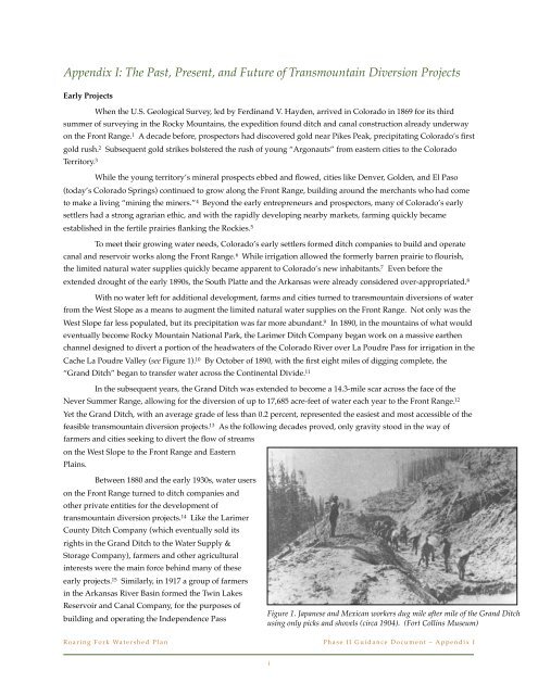
The Past, Present, and Future of Transmountain Diversion Projects
The Past, Present, and Future of Transmountain Diversion Projects
The Past, Present, and Future of Transmountain Diversion Projects

You also want an ePaper? Increase the reach of your titles
YUMPU automatically turns print PDFs into web optimized ePapers that Google loves.
<strong>Transmountain</strong> <strong>Diversion</strong> Project. Today, that project diverts up to 39,292 acre-feet <strong>of</strong> water annually from theheadwaters <strong>of</strong> the Roaring Fork River to the Arkansas River Basin. 16<strong>The</strong> Colorado-Big Thompson ProjectBy the 1930s many <strong>of</strong> the easier transmountain diversions were already built, <strong>and</strong> further developmentrequired increasingly elaborate <strong>and</strong> costly projects. 17 At the same time, the first summers <strong>of</strong> the Dust Bowl scorchedthe plains, ruining nearly $47 million <strong>of</strong> crops in the eastern half <strong>of</strong> Colorado. 18 <strong>The</strong> growing sense <strong>of</strong> urgency amongfarmers spurred Colorado to push for federal support <strong>of</strong> a major transmountain diversion project that would divertwater from the headwaters <strong>of</strong> the Colorado River to the South Platte River Basin. 19 While the proposal initiallygenerated stiff opposition from West Slope <strong>and</strong> environmental interests, in 1937 Congress authorized the Bureau <strong>of</strong>Reclamation to build the Colorado-Big Thompson (C-BT) Project. 20With 12 reservoirs, 35 miles <strong>of</strong> tunnels, <strong>and</strong> 95 miles <strong>of</strong> canals, construction <strong>of</strong> the C-BT Project would takenearly two decades. Project water was first diverted from Gr<strong>and</strong> Lake to the East Slope in 1957, through the 13.1-mileAlva B. Adams Tunnel underneath Rocky Mountain National Park <strong>and</strong> the Continental Divide. Today, the C-BT isColorado’s largest transmountain diversion project, diverting approximately 213,000 acre-feet <strong>of</strong> water on averageeach year from the headwaters <strong>of</strong> the Colorado River to the South Platte River basin. Altogether the project providessupplemental water to thirty cities <strong>and</strong> towns <strong>and</strong> allows for the irrigation <strong>of</strong> roughly 693,000 acres <strong>of</strong> l<strong>and</strong> innortheastern Colorado.One <strong>of</strong> the issues that had to be resolved before Congress would authorize the C-BT Project was thepotential impacts to water users on Colorado’s West Slope. 21 While the West Slope was sparsely populated,agriculture was already well established, thanks largely to the earlier construction <strong>of</strong> two major irrigation projects bythe Bureau <strong>of</strong> Reclamation. 22 West Slope residents had no intention <strong>of</strong> st<strong>and</strong>ing by as the headwaters <strong>of</strong> the ColoradoRiver were diverted to the Front Range, initially dem<strong>and</strong>ing acre-foot for acre-foot compensation for any water takenfrom the Colorado River. 23 Eventually the two sides <strong>of</strong> the divide reached a compromise in the form <strong>of</strong> GreenMountain Reservoir, a component <strong>of</strong> the C-BT Project that was built as compensatory storage for existing <strong>and</strong> futureWest Slope water dem<strong>and</strong>s. 24 With a capacity <strong>of</strong> approximately 153,000 acre-feet, Green Mountain Reservoir providesenough storage to satisfy senior water rights in the Colorado River Basin, as well as an additional 20,000 acre-feet <strong>of</strong>water that the Bureau <strong>of</strong> Reclamation contracts out to West Slope water users. 25Later Compensatory Storage <strong>Projects</strong>With the agreement brokered for the C-BT Project as a model, in 1943 the Colorado General Assemblyamended the Water Conservancy Act to make compensatory storage a requirement for any project exporting waterfrom the Colorado River Basin that is owned or operated by a water conservancy district. 26 In the following decades,this compensatory storage requirement served as the foundation for the construction <strong>of</strong> additional transmountaindiversion projects, both federal <strong>and</strong> nonfederal. In 1962 Congress authorized the construction <strong>of</strong> the Fryingpan-Arkansas Project, after West Slope interests <strong>and</strong> the Southeastern Colorado Water Conservancy District agreed to theconstruction <strong>of</strong> Ruedi Reservoir as the compensatory storage component <strong>of</strong> the project. Likewise in 1970 theMunicipal Subdistrict for the Northern Colorado Water Conservancy District was permitted to construct the WindyGap Project (a major expansion <strong>of</strong> the C-BT Project) after the Subdistrict agreed to provide financial support for theconstruction <strong>of</strong> Wolford Mountain Reservoir. 27However since the Water Conservancy Act only applies to water conservancy districts, just three <strong>of</strong> thenearly thirty transmountain diversion projects in Colorado are subject to the compensatory storage requirement (seeRoaring Fork Watershed Plan!Phase II Guidance Document – Appendix Iii
Figure 2. <strong>Transmountain</strong> diversions in Colorado. <strong>The</strong> only diversions subject to the compensatory storage requirement are thosethrough the Adams Tunnel (8) (C-BT <strong>and</strong> Windy Gap projects) <strong>and</strong> the Boustead Tunnel (19) (Fryingpan-Arkansas Project). (StateEngineers Office)Figure 2). 28 <strong>The</strong> concept <strong>of</strong> compensatory storage is also increasingly limited as a tool for negotiation between East<strong>and</strong> West Slope water interests. 29 One <strong>of</strong> the main reasons for the diminished interest in compensatory storage is thereduced dem<strong>and</strong> for additional water storage on the West Slope. 30 Numerous reservoirs on the West Slope alreadyprovide for the storage <strong>of</strong> spring run<strong>of</strong>f, <strong>and</strong> the availability <strong>of</strong> other feasible reservoir sites is limited. 31 Moreover,the West Slope is transitioning from a mining <strong>and</strong> agricultural based economy to one increasingly centered aroundtourism <strong>and</strong> second-home ownership, both <strong>of</strong> which value the environmental <strong>and</strong> recreational benefits provided bymaintaining instream flows. 32<strong>The</strong> Two Forks <strong>and</strong> Homestake II <strong>Projects</strong><strong>The</strong> potential roadblock that environmental <strong>and</strong> recreational interests pose to additional transmountaindiversion projects was demonstrated by the relatively recent defeat <strong>of</strong> two major water supply projects for the FrontRange. In 1990, after nearly fifty years <strong>of</strong> planning <strong>and</strong> more than $40 million spent on various feasibility studies, theEnvironmental Protection Agency (EPA) vetoed Denver Water’s Two Forks Project, based on the potential impact t<strong>of</strong>isheries, wildlife, <strong>and</strong> recreational values. 33 Two years later, after more than two decades <strong>of</strong> fierce litigation, localinterests in Eagle County also successfully defeated the Homestake II Project, again based on environmentalconcerns, in particular, the potential impacts to wetl<strong>and</strong> areas in the recently-formed federal Holy Cross WildernessArea. 34Both the Two Forks <strong>and</strong> Homestake II projects were ultimately defeated because their proponents failed toaccount for the impacts associated with transmountain diversions on environmental <strong>and</strong> recreational values in thebasin-<strong>of</strong>-origin. While local environmental <strong>and</strong> recreational interests will never be paramount to the need to ensureRoaring Fork Watershed Plan!Phase II Guidance Document – Appendix Iiii
Figure 3. Population growth on the Front Range in the 20th century.adequate water supplies for the growing Front Range,no longer can East Slope water providers simply makesupply planning <strong>and</strong> development decisions basedsolely on cost alone. 35Yet the demise <strong>of</strong> the Two Forks <strong>and</strong>Homestake II projects represented more than just anincreased emphasis on environmental <strong>and</strong> recreationalinterests. To fully underst<strong>and</strong> the implications <strong>of</strong> thesetwo projects, it is necessary to consider how they fitwithin the larger story <strong>of</strong> Colorado water law.Colorado’s unique approach to water lawwas originally tailored for mining <strong>and</strong> irrigationpurposes. Yet for most <strong>of</strong> the twentieth century, asColorado grew from a rural territory to anincreasingly metropolitan state, water laws wererefashioned to support nearly unlimited urban growth. 36 For example, in 1939, when the City <strong>of</strong> Denver soughtjudicial decrees for its West Slope water rights on the Fraser <strong>and</strong> Williams Fork rivers, the Colorado Supreme Courtdeveloped an exception to the traditional anti-speculation rule, thereby allowing municipalities to obtain conditionalrights based on reasonably anticipated future water dem<strong>and</strong>s. 37 Similarly in 1969 the Colorado General Assemblyenacted a statute that provides that foreign water, once diverted from its natural basin <strong>of</strong> origin, can be used toextinction, thereby making such water largely exempt from the prior appropriation system <strong>and</strong> allowing major watersupply project developers to realize the maximum value <strong>of</strong> “developed” water through re-use <strong>and</strong> re-application. 38As a result <strong>of</strong> these <strong>and</strong> other similar decisions <strong>and</strong> enactments, Front Range water providers were able to secure vastamounts <strong>of</strong> West Slope water for diversion to the East Slope. 39<strong>The</strong> demise <strong>of</strong> Two Forks <strong>and</strong> Homestake II reversed the course <strong>of</strong> water supply planning <strong>and</strong> developmentin Colorado, particularly for water providers on the Front Range. Eagle County’s defeat <strong>of</strong> the Homestake II Projectdemonstrated the new found permitting power <strong>of</strong> local interests over proposed transmountain diversion projects. 40With the authority conferred to counties <strong>and</strong> municipalities in House Bill 1041, Front Range water providers could nolonger steamroll West Slope interests in developing additional transmountain water supplies. 41 Today, localpermitting has the potential to pose as significant a hurdle for proposed transmountain diversion projects as anyfederal <strong>and</strong> state levels <strong>of</strong> review.Metro Denver comprises Adams, Arapahoe, Boulder Broomfield, Denver,Douglas, <strong>and</strong> Jefferson counties. Northern Colorado comprises Larimer <strong>and</strong>Weld counties. (Metro Denver Economic Development Corporation)Changing Water Supply Responsibilities on the Front RangeIf Homestake II represented the decentralization <strong>of</strong> permitting authority over transmountain diversionprojects, the demise <strong>of</strong> the Two Forks Project represented the decentralization <strong>of</strong> the planning authority over suchprojects, particularly with respect to Denver Water. Prior to EPA’s veto <strong>of</strong> the Two Forks Project, suburban areasgrowing up around the City <strong>of</strong> Denver would <strong>of</strong>ten elect to be annexed into the city in order to obtain water suppliedby Denver Water, <strong>and</strong> even areas that avoided annexation would still contract with Denver Water for their watersupplies. 42 As the population on the Front Range exploded in the latter half <strong>of</strong> the twentieth century (see Figure 3),water planning was increasingly centered around Denver Water.In the wake <strong>of</strong> the Two Forks veto, it became clear that Denver Water could no longer take responsibility forthe water supply future <strong>of</strong> a rapidly exp<strong>and</strong>ing Denver metropolitan area. 43 As Denver Water’s board <strong>of</strong> directorsfinally concluded, there were too many political, legal, <strong>and</strong> economic constraints, <strong>and</strong> too few opportunities toRoaring Fork Watershed Plan!Phase II Guidance Document – Appendix Iiv
Figure 4. In March <strong>of</strong> 2009, workers began pouring thefoundation for the 10 million gallon Robertsdale Tank, a keycomponent <strong>of</strong> the Prairie Waters Project. (Aurora Water)develop significant new water supplies, for Denver Water tocontinue to plan for potentially unlimited population growth. 44In 1993 Denver Water announced that it would no longerenlarge its service area, instead drawing a defined service areaboundary. 45! Denver Water’s decision to limit its service area hadwidespread implications for other water providers on theFront Range. Most importantly, the decision meant thatbooming suburban areas excluded from Denver Water’sservice area would be forced to find water supplies forthemselves, without the option <strong>of</strong> relying on Denver Water’ssenior conditional West Slope water rights. 46 Withoutidentifiable sources <strong>of</strong> water to meet projected future dem<strong>and</strong>s, Front Range communities have had to scramble todevelop additional water projects, a challenging <strong>and</strong> expensive task in Colorado today. <strong>The</strong> City <strong>of</strong> Aurora, forexample, is close to completing the $754 million Prairie Waters Project, which will recycle used water from the SouthPlatte River in order to boost the city’s water supplies by some twenty percent (see Figure 4). 47 Similarly, the ParkerWater <strong>and</strong> Sanitation District has begun construction on the Rueter-Hess Reservoir, with an expected capacity <strong>of</strong>roughly 77,000 acre-feet <strong>of</strong> water, some <strong>of</strong> which is expected to be recycled (though the district has yet to identify thesource for a large portion <strong>of</strong> the reservoir’s capacity). 48 <strong>The</strong>se projects represent not only groundbreaking waterconservation <strong>and</strong> reuse projects, but also the available options for municipalities seeking additional water inColorado’s ever-tightening water supply. 49<strong>The</strong> Two Forks veto also forced Denver Water to revise its overall strategy for developing additionaltransmountain water supplies. Not only did Denver Water recognize the need to pursue water projects in anenvironmentally responsible manner, but more importantly, it decided not to undertake any future transmountaindiversion projects without first securing the cooperation <strong>of</strong> effected West Slope entities. 50 <strong>The</strong> need for such acooperative approach to future water supply projects has since been recognized by other Front Range waterproviders. 51 Today water interests on the Front Range recognize that new transmountain diversion projects will onlybe built if they are mutually beneficial to both sides <strong>of</strong> the Continental Divide. 52<strong>The</strong> Windy Gap Firming Project, M<strong>of</strong>fat System Expansion <strong>and</strong> Other Current Project Proposals<strong>The</strong> negotiations surrounding the two most recent transmountain diversion proposals – the MunicipalSubdistrict’s Windy Gap Firming Project <strong>and</strong> Denver Water’s M<strong>of</strong>fat System Expansion – demonstrate the level <strong>of</strong>cooperation required for such projects to survive beyond the conceptual stage. First, both projects follow theimplementation <strong>of</strong> progressive water conservation measures on the East Slope, a step that West Slope interests havedem<strong>and</strong>ed occur before additional diversions are even considered. 53 Likewise, both projects employ existing facilities<strong>and</strong> infrastructure <strong>and</strong> previously decreed conditional water rights, which West Slope interests have alsodem<strong>and</strong>ed. 54Yet the most important part <strong>of</strong> the Windy Gap Firming Project <strong>and</strong> M<strong>of</strong>fat System Expansion are thepotential West Slope benefits currently being proposed as part <strong>of</strong> the projects. <strong>The</strong> Municipal Subdistrict <strong>and</strong> DenverWater have teamed up to <strong>of</strong>fer a package <strong>of</strong> West Slope mitigation measures that would compensate for the impactsassociated with both projects. 55 <strong>The</strong>se measures include voluntary bypasses for transmountain diversion structures,as well as financial support for improved wastewater treatment <strong>and</strong> stream habitat restoration in the upper ColoradoRiver Basin. 56 Currently, West Slope interests are reviewing the proposal <strong>and</strong> negotiations are far from complete. 57Roaring Fork Watershed Plan!Phase II Guidance Document – Appendix Iv
Yet the process that is unfolding promises a new chapter in water supply development for Colorado. As one Gr<strong>and</strong>County commissioner said in reaction to the proposal, “Maybe West Slope <strong>and</strong> East Slope can work together for thegood <strong>of</strong> Colorado.” 58<strong>The</strong> potential for additional transmountain diversions is a reality that West Slope interests must be preparedfor. According to the most recent state estimates, Colorado’s population is expected to nearly double by 2050,requiring between 830,000 <strong>and</strong> 1.7 million acre-feet <strong>of</strong> additional water to meet municipal <strong>and</strong> industrial needs. 59 Inaddition to these “consumptive” dem<strong>and</strong>s, the Basin Roundtables are currently working to identify the“nonconsumptive” water needs (i.e., environmental <strong>and</strong> recreational needs) within their respective basins. 60 <strong>The</strong>Interbasin Compact Committee (IBCC) is attempting to identify a range <strong>of</strong> water supply development scenarios thatcan meet the state’s consumptive <strong>and</strong> nonconsumptive needs, <strong>and</strong> the various approaches rely on a mix <strong>of</strong>conservation, agricultural transfers, <strong>and</strong> new water supply development. 61Three major transmountain diversions are the current focus <strong>of</strong> planning efforts related to the InterbasinCompact Process – the Colorado River Return, the Yampa Pumpback, <strong>and</strong> the Flaming Gorge Pipeline. 62 <strong>The</strong>Colorado River Return, also known as the “Big Straw,” would pump water from the Colorado River at the stateborder back up the mainstem <strong>of</strong> the Colorado River to the Continental Divide, somewhere near Avon. 63 One routefor the proposed pipeline would transect the Roaring Fork Valley, crossing through the Four-Mile Creek area. 64 <strong>The</strong>Yampa Pumpback would divert water downstream <strong>of</strong> Craig, pump the water upstream <strong>and</strong> through the North PlatteRiver Basin, to be discharged into the Poudre River <strong>and</strong> the South Platte River Basin. 65 Finally, the Flaming GorgePipeline would carry water from the Green River <strong>and</strong> the Flaming Gorge Reservoir (in southwestern Wyoming) toColorado’s Front Range. 66<strong>The</strong> IBCC is currently trying to develop a better idea <strong>of</strong> the feasibility <strong>of</strong> each project <strong>and</strong> the degree towhich they could help address Colorado’s long-term water needs. <strong>The</strong> IBCC discussions could potentially lead to theauthorization <strong>of</strong> one or more <strong>of</strong> these projects. <strong>The</strong> Interbasin Compact Process provides a structured means bywhich opposing interests can be identified <strong>and</strong> negotiations initiated at an early stage – to ensure that projectproposals are not derailed. Thus, while transmountain diversion projects have never been more complicated orexpensive, they also are again attainable. West Slope water interests must be vigilant to ensure that any futuretransmountain diversions are in the best interests <strong>of</strong> both the West Slope <strong>and</strong> the State <strong>of</strong> Colorado as a whole.Roaring Fork Watershed Plan!Phase II Guidance Document – Appendix Ivi
1See Cyrus Thomas, “Agriculture <strong>of</strong> Colorado,” reprinted in Ferdin<strong>and</strong> V. Hayden, Preliminary Field Report <strong>of</strong> the United StatesGeological Survey <strong>of</strong> Colorado <strong>and</strong> New Mexico, Govt. Printing Office, 133-155 (1869).2Carl Ubbelohde, Maxine Benson, <strong>and</strong> Duane A. Smith, A Colorado History, 56-62 (7th ed., Pruett Publg. Co. 1995)3Id. at 65-66. (Two gold strikes that generated much <strong>of</strong> the attention were at Gold Hill, near the present-day City <strong>of</strong> Boulder, <strong>and</strong>Gregory Gulch, near Blackhawk.)4Id. at 60, 62.5See Thomas, supra n. 1 at 142 (noting that, as <strong>of</strong> 1869, roughly one-fifth <strong>of</strong> Colorado’s population was engaged in farming, “But theone must draw the other – those who mine must eat – <strong>and</strong> the heavy expense <strong>of</strong> bringing food from the States is working out itsown cure. <strong>The</strong> necessity for moving forward the agricultural interests <strong>of</strong> the country are being felt <strong>and</strong> acted on.”) See also Thomas,supra n. 1 at 154 (estimating that Colorado’s crop <strong>of</strong> 1869 included 675,000 bushels <strong>of</strong> wheat, 600,000 bushels <strong>of</strong> corn, 550,000 bushels<strong>of</strong> oats <strong>and</strong> barley, <strong>and</strong> 350,000 bushels <strong>of</strong> potatoes <strong>and</strong> other vegetables, which, when the hay <strong>and</strong> dairy product were included, hada potential market value <strong>of</strong> not less than $3.5 million).6Id. at 150 (noting that the practice <strong>of</strong> forming mutual ditch companies was widely employed, as it greatly reduced the cost <strong>of</strong>irrigating large areas <strong>of</strong> previously undeveloped l<strong>and</strong>s).7Id. at 140 (noting that “<strong>The</strong> troublesome factor in the great problem <strong>of</strong> the development <strong>of</strong> the agricultural capacity <strong>of</strong> the vastwestern plains is the supply <strong>of</strong> water. Furnish this, <strong>and</strong> the ‘Great American Desert’ <strong>of</strong> old geographers will soon become onemighty field <strong>of</strong> flowing grain. Furnish this, <strong>and</strong> the few other minor impeding factors will soon be eliminated.”)8See e.g., Frederick Haynes Newell, “Report on agriculture by irrigation in the western part <strong>of</strong> the United States at the EleventhCensus: 1890,” U.S. Census Office (1894) (describing annual river calls on the Arkansas River, in Chaffee County (p. 104) <strong>and</strong>Fremont County (p. 110), as well as annual river calls on the South Platte River, in Jefferson County (p. 114)). See also Dick Wolfe,“Surface Water <strong>and</strong> Ground Water Administration in Colorado: Water 101,” State Engineers Office (Feb. 24, 2004) (available athttp://water.state.co.us/pubs/presentations/wateradmin101.pdf).9Colorado is still grappling with what is commonly referred to as the “80-20” problem, which refers to the fact that roughly 80percent <strong>of</strong> the state’s population resides on the East Slope, where only 20 percent <strong>of</strong> the state’s precipitation falls.10Phyllis J. Perry, It Happened in Rocky Mountain National Park, Morris Book Publishing Co., 36 (2008). See also C. W. Buchholtz, RockyMountain National Park: A History, Colo. Assoc. Univ. Press (1983).11Initially the ditch was called the “Gr<strong>and</strong> River Ditch,” but the name was changed in 1907, when the name <strong>of</strong> the Gr<strong>and</strong> River waschanged to the Colorado River.12Id. at 37.13<strong>The</strong> 14.3 mile-long Gr<strong>and</strong> Ditch runs east from Baker Creek, at an elevation <strong>of</strong> about 10,300 feet, to La Poudre Pass, at an elevation<strong>of</strong> 10,179 feet, an average grade <strong>of</strong> less than 0.2 percent.14<strong>The</strong> first transmountain diversion in Colorado occurred near Fairplay in 1860. Built for mining purposes, the ditch was shortlyab<strong>and</strong>oned after local placer mining played out. <strong>The</strong> earliest transmountain diversion still in operation is the Ewing Ditch,constructed in 1880, which diverts water from the headwaters <strong>of</strong> the Eagle River to the Arkansas River Basin.15Perry, supra n. 11 at 36.16Roaring Fork Watershed Plan, “<strong>The</strong> State <strong>of</strong> the Roaring Fork Watershed Report,” § 2.2.3 (Nov. 2008) (available at http://www.roaring fork.org/ sitepages/pid175.php.)17Peter D. Nichols, Megan K. Murphy, <strong>and</strong> Douglas S. Kenney, “Water <strong>and</strong> Growth in Colorado: A Review <strong>of</strong> Legal <strong>and</strong> PolicyIssues,” Natural Resources Law Center, Univ. <strong>of</strong> Colo. School <strong>of</strong> Law (2001).Roaring Fork Watershed Plan!Phase II Guidance Document – Appendix Ivii
18Robert Autobee, “Colorado-Big Thompson Project,” Bureau <strong>of</strong> Reclamation History Program (1996) (available at http://www.usbr.gov/projects/Project.jsp?proj_Name=Colorado-Big%20Thompson%20Project&pageType=ProjectHistoryPage)19Id.20Id.21Id. (<strong>The</strong> roadblock in Congress was Representative Edward T. Taylor, from Glenwood Springs, who was a member <strong>of</strong> the HouseAppropriations Committee <strong>and</strong> the former chair <strong>of</strong> the House Committee on Irrigation <strong>of</strong> Arid L<strong>and</strong>s.)22<strong>The</strong> Bureau <strong>of</strong> Reclamation completed the Uncompahgre Project in 1912 <strong>and</strong> the Gr<strong>and</strong> Valley Project in 1917, allowing for theirrigation <strong>of</strong> tens <strong>of</strong> thous<strong>and</strong>s <strong>of</strong> acres in the Gr<strong>and</strong>, Gunnison, <strong>and</strong> lower Uncompahgre valleys.23See R. Autobee, supra n. 18. See also Steven Schulte, “HB 1177: Water War <strong>and</strong> (or) Peace?,” Colo. Water, 7 (Aug. 2005).24This agreement was memorialized in the congressional authorization for the C-BT Project, known as “Senate Document 80.” <strong>The</strong>complete title <strong>of</strong> Senate Document 80 is “Synopsis <strong>of</strong> Report on Colorado Big Thompson Project, Plan <strong>of</strong> Development <strong>and</strong> CostEstimate, prepared by the Bureau <strong>of</strong> Reclamation, Department <strong>of</strong> the Interior, 75th Congress, First Session, June 15, 1937.”25Erik Kuhn, “Green Mountain Contracting Policy,” Memo to Board <strong>of</strong> Directors, Colo. River Water Conserv. Dist., Oct. 8, 2009(available at http://www.crwcd.org/media/uploads/20091020gm.pdf).26Colo. Rev. Stat. § 37-45-118(b)(II) (Lexis 2008) (requiring that the facilities <strong>of</strong> a water conservancy district must be designed,constructed, <strong>and</strong> operated in such manner that present appropriations <strong>and</strong> prospective uses <strong>of</strong> water within the Colorado RiverBasin “will not be impaired nor increased in cost.”)27In 1979, the Colorado Supreme Court ruled that the Windy Gap Project had to comply with the Water Conservancy Act. Colo.River Water Conserv. Dist. v. Mun. Subdist., N. Colo. Water Conservancy Dist., 610 P.2d 81 (Colo. 1979). <strong>The</strong> decision led to the 1980Azure-Windy Gap Agreement whereby the proposed Azure Reservoir would serve as the compensatory component to the WindyGap Project. In 1982, the Municipal Subdistrict proposed building a major pumpback project to satisfy its obligation to build theAzure Reservoir. After the Colorado River Water Conservation District, the Middle Park Conservancy District, <strong>and</strong> Gr<strong>and</strong> Countyobjected, the parties agreed to an Azure-Windy Gap supplemental agreement, whereby the Municipal Subdistrict provided theRiver District with $10.2 million for the construction <strong>of</strong> Wolford Mountain Reservoir. See Erik Kuhn, “Historical Perspective for2007,” Colo. River Water Conserv. District (Jan. 16, 2007).28<strong>The</strong> three transmountain diversion projects subject to the compensatory storage requirement are the C-BT Project, the Windy GapProject, <strong>and</strong> the Fryingpan-Arkansas Project.29Nichols et al., supra n. 17 at 42-43.30This trend is not, however, certain to continue. While significant growth is projected for the Front Range, the West Slope, alongthe Colorado River mainstem in particular, is actually expected to grow at a faster rate. Municipalities, even more so than farms,require a high degree <strong>of</strong> certainty in their water supplies, necessitating water storage systems that can continue to provide a steadysupply <strong>of</strong> water during droughts <strong>and</strong> the lower winter flows. Likewise, snowmaking <strong>of</strong>ten requires water during lower winterflows, which can also drive the dem<strong>and</strong> for additional water storage. Yet, while the need for additional storage capacity is possiblein the future, there is no currently foreseeable dem<strong>and</strong> to justify new compensatory storage projects (see subsequent endnote).31<strong>The</strong> three main compensatory storage reservoirs – Green Mountain, Ruedi, <strong>and</strong> Wolford Mountain – have excess capacity that iscurrently not under contract. <strong>The</strong> total amount <strong>of</strong> uncontracted water for each <strong>of</strong> these reservoirs is as follows: Green MountainReservoir, 10,289 acre-feet; Ruedi Reservoir, 16,700 acre-feet; <strong>and</strong> Wolford Mountain Reservoir, 20,000 acre-feet. This water isreserved for the future needs <strong>of</strong> the West Slope, <strong>and</strong> its availability counteracts any proposed additional compensatory storage.32N.W. Colo. Council <strong>of</strong> Govts., “Job Generation in the Colorado Mountain Resort Economy: Second Homes <strong>and</strong> Other EconomicDrivers in Eagle, Gr<strong>and</strong>, Pitkin, <strong>and</strong> Summit Counties,” (Jun. 2004) (available at http://www.nwc.cog.co.us/index.php/resources/nwccog-reports-studies/)Roaring Fork Watershed Plan!Phase II Guidance Document – Appendix Iviii
33U.S. Envtl. Protec. Agency, Region VIII, “Recommended Determination to Prohibit Construction <strong>of</strong> Two Forks Dam <strong>and</strong> ReservoirPursuant to Section 404(c) <strong>of</strong> the Clean Water Act,” (Mar. 1990) (EPA based its decision on the fact that “Construction <strong>and</strong> operation<strong>of</strong> the project would have unacceptable adverse effects on fishery areas (including spawning <strong>and</strong> breeding grounds), wildlife, <strong>and</strong>recreation areas. Furthermore, the record demonstrates the existence <strong>of</strong> practicable, environmentally less damaging alternatives tothe proposed project.”)34See City <strong>of</strong> Colo. Springs v. Bd. <strong>of</strong> Co. Commrs., 895 P.2d 1105 (Colo. App. 1994).35Denver Water, “Water for Tomorrow: An Integrated Water Resource Plan,” 4 (Feb. 2002) (noting that “In the era beforeenvironmental regulation, Denver Water’s planning consisted largely <strong>of</strong> turning to the structural project that was least costly <strong>and</strong>highest-yielding to meet increased water dem<strong>and</strong>”) (available at http://www.denverwater.org/SupplyPlanning/Planning/<strong>Future</strong>WaterSupply/IntegratedResourcePlan/).36Dan A. Tarlock <strong>and</strong> Sarah B. Van de Wetering, “Growth Management <strong>and</strong> Western Water Law: From Urban Oases toArchipelagos,” 5 Hastings W.-N.W. J. <strong>of</strong> Envtl. L. & Policy 163, 172 (1999).37City <strong>and</strong> Co. <strong>of</strong> Denver v. Sheriff, 105 Colo. 193, 202 (Colo. 1939) (holding that “it is not speculation but the highest prudence on thepart <strong>of</strong> the city to obtain appropriations <strong>of</strong> water that will satisfy the needs resulting from a normal increase in population within areasonable period <strong>of</strong> time.”)38Colo. Rev. Stat. § 37-82-106 (Lexis 2009). For a detailed history <strong>of</strong> the development <strong>of</strong> this provision, see City <strong>of</strong> Thornton v. BujouIrrigation Co., 926 P.2d 1 (Colo. 1996).39See P. Nichols, supra n. 17 at 39-40.40For further discussion, see section on House Bill 1041 <strong>and</strong> the Homestake II dispute in the main body <strong>of</strong> this report.41See Ge<strong>of</strong>fry M. Craig, “House Bill 1041 <strong>and</strong> Transbasin Water <strong>Diversion</strong>s: Equity to the Western Slope or Undue Power to LocalGovernment?,” 66 U. Colo. L. Rev. 791 (1995).42Denver Water, supra n. 35 at 2.43Id. at 2-3.44Id.45Id.46See Ed Marston, “Ripples grow when a dam dies,” High Country News (Oct. 31, 1994) (quoting Chips Barry, Manager for DenverWater, on the changes to his organization’s water policy in the wake <strong>of</strong> the Two Forks veto: “We won’t solve the water supplyproblem for the Front Range. North Douglas County (Castle Rock, Parker, et al) doesn’t have a water supply, <strong>and</strong> we’re not going toprovide one.”)47See Prairie Waters Project website, “Project Overview,” (2007) (available at http://www.prairiewaters.org/).48See U.S. Army Corps <strong>of</strong> Engrs., Omaha Dist., “Supplemental Environmental Impact Statement: Rueter-Hess ReservoirExpansion” (Nov. 2007).49See e.g., Bruce Finley, “Parker water board recall fails,” Denver Post (Dec. 17, 2009).50Denver Water, supra n. 35 at 8.51See George Sibley, “Colorado’s Water for the 21st Century Act: Finally doing the right thing?,” Headwaters, 7 (Spring 2009).52For a current example <strong>of</strong> such negotiations, see Tonya Bina, “Gr<strong>and</strong> County hopes to benefit from Front Range water-firmingprojects,” Sky-Hi Daily News (Jan. 15, 2010).Roaring Fork Watershed Plan!Phase II Guidance Document – Appendix Iix
53See Mun. Subdist., “Facts: <strong>The</strong> Windy Firming Project,” 1 (2009) (available at http://www.chimneyhollow.org/Press.aspx). Alsosee U.S. Army Corps <strong>of</strong> Engrs., Omaha Dist., “Draft Environmental Impact Statement: M<strong>of</strong>fat Collection System Project,” ES-2-4, 6(Oct. 31, 2009) (available at https://www.nwo.usace.army.mil/html/od-tl/eis/m<strong>of</strong>fat-deis-docs.html).54Id. Regarding the West Slope’s position on transmountain diversion projects, see Colo. River Water Conserv. Dist., “Existing<strong>Transmountain</strong> <strong>Diversion</strong> <strong>Projects</strong>” (Jul. 15, 2008); see also Colo. River Water Conserv. Dist., “<strong>Transmountain</strong> Water <strong>Diversion</strong>s” (Apr.16, 2008) (both documents available at http://www.crwcd.org/page_9).55Mark Jaffe, “Colorado water war ends in deal,” Denver Post (May 1, 2009) (despite the article’s intimation, no deal has yet beenstruck). See also Denver Water, Citizens Advisory Comm., “CAC Minutes for Meeting <strong>of</strong> May 21, 2009” (May 21, 2009) (noting thatthe agreement is not yet formalized).56Id.57Color. River Water Conserv. Dist., “Minutes: Third Quarterly Meeting <strong>of</strong> the Board <strong>of</strong> Directors <strong>of</strong> the Colorado WaterConservation District,” 2-3 (July 21-22, 2009).58As quoted in Jaffe, supra n. 55.59Colo. Water Conservation Bd., “Draft Report – State <strong>of</strong> Colorado 2050 Municipal <strong>and</strong> Industrial Water Use Projections,” §§ 2.2 <strong>and</strong>5.2 (Jun. 2009) (available at http://cwcb.state.co.us/IWMD/COsWaterSupply<strong>Future</strong>/CosWaterSupply<strong>Future</strong>.htm).60Colo. Rev. Stat. § 37-75-105(2)(c) (Lexis 2008).61See Colo. Water Conservation Bd., “Draft Report – Strategies for Colorado's Water Supply <strong>Future</strong>” § 1.2.2 (2009)62Id. at § 4.1.1.2.63Id.64Id.65Id.66Id.Roaring Fork Watershed Plan!Phase II Guidance Document – Appendix Ix