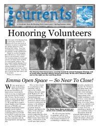
The Past, Present, and Future of Transmountain Diversion Projects
The Past, Present, and Future of Transmountain Diversion Projects
The Past, Present, and Future of Transmountain Diversion Projects

You also want an ePaper? Increase the reach of your titles
YUMPU automatically turns print PDFs into web optimized ePapers that Google loves.
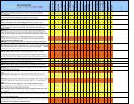
1See Cyrus Thomas, “Agriculture <strong>of</strong> Colorado,” reprinted in Ferdin<strong>and</strong> V. Hayden, Preliminary Field Report <strong>of</strong> the United StatesGeological Survey <strong>of</strong> Colorado <strong>and</strong> New Mexico, Govt. Printing Office, 133-155 (1869).2Carl Ubbelohde, Maxine Benson, <strong>and</strong> Duane A. Smith, A Colorado History, 56-62 (7th ed., Pruett Publg. Co. 1995)3Id. at 65-66. (Two gold strikes that generated much <strong>of</strong> the attention were at Gold Hill, near the present-day City <strong>of</strong> Boulder, <strong>and</strong>Gregory Gulch, near Blackhawk.)4Id. at 60, 62.5See Thomas, supra n. 1 at 142 (noting that, as <strong>of</strong> 1869, roughly one-fifth <strong>of</strong> Colorado’s population was engaged in farming, “But theone must draw the other – those who mine must eat – <strong>and</strong> the heavy expense <strong>of</strong> bringing food from the States is working out itsown cure. <strong>The</strong> necessity for moving forward the agricultural interests <strong>of</strong> the country are being felt <strong>and</strong> acted on.”) See also Thomas,supra n. 1 at 154 (estimating that Colorado’s crop <strong>of</strong> 1869 included 675,000 bushels <strong>of</strong> wheat, 600,000 bushels <strong>of</strong> corn, 550,000 bushels<strong>of</strong> oats <strong>and</strong> barley, <strong>and</strong> 350,000 bushels <strong>of</strong> potatoes <strong>and</strong> other vegetables, which, when the hay <strong>and</strong> dairy product were included, hada potential market value <strong>of</strong> not less than $3.5 million).6Id. at 150 (noting that the practice <strong>of</strong> forming mutual ditch companies was widely employed, as it greatly reduced the cost <strong>of</strong>irrigating large areas <strong>of</strong> previously undeveloped l<strong>and</strong>s).7Id. at 140 (noting that “<strong>The</strong> troublesome factor in the great problem <strong>of</strong> the development <strong>of</strong> the agricultural capacity <strong>of</strong> the vastwestern plains is the supply <strong>of</strong> water. Furnish this, <strong>and</strong> the ‘Great American Desert’ <strong>of</strong> old geographers will soon become onemighty field <strong>of</strong> flowing grain. Furnish this, <strong>and</strong> the few other minor impeding factors will soon be eliminated.”)8See e.g., Frederick Haynes Newell, “Report on agriculture by irrigation in the western part <strong>of</strong> the United States at the EleventhCensus: 1890,” U.S. Census Office (1894) (describing annual river calls on the Arkansas River, in Chaffee County (p. 104) <strong>and</strong>Fremont County (p. 110), as well as annual river calls on the South Platte River, in Jefferson County (p. 114)). See also Dick Wolfe,“Surface Water <strong>and</strong> Ground Water Administration in Colorado: Water 101,” State Engineers Office (Feb. 24, 2004) (available athttp://water.state.co.us/pubs/presentations/wateradmin101.pdf).9Colorado is still grappling with what is commonly referred to as the “80-20” problem, which refers to the fact that roughly 80percent <strong>of</strong> the state’s population resides on the East Slope, where only 20 percent <strong>of</strong> the state’s precipitation falls.10Phyllis J. Perry, It Happened in Rocky Mountain National Park, Morris Book Publishing Co., 36 (2008). See also C. W. Buchholtz, RockyMountain National Park: A History, Colo. Assoc. Univ. Press (1983).11Initially the ditch was called the “Gr<strong>and</strong> River Ditch,” but the name was changed in 1907, when the name <strong>of</strong> the Gr<strong>and</strong> River waschanged to the Colorado River.12Id. at 37.13<strong>The</strong> 14.3 mile-long Gr<strong>and</strong> Ditch runs east from Baker Creek, at an elevation <strong>of</strong> about 10,300 feet, to La Poudre Pass, at an elevation<strong>of</strong> 10,179 feet, an average grade <strong>of</strong> less than 0.2 percent.14<strong>The</strong> first transmountain diversion in Colorado occurred near Fairplay in 1860. Built for mining purposes, the ditch was shortlyab<strong>and</strong>oned after local placer mining played out. <strong>The</strong> earliest transmountain diversion still in operation is the Ewing Ditch,constructed in 1880, which diverts water from the headwaters <strong>of</strong> the Eagle River to the Arkansas River Basin.15Perry, supra n. 11 at 36.16Roaring Fork Watershed Plan, “<strong>The</strong> State <strong>of</strong> the Roaring Fork Watershed Report,” § 2.2.3 (Nov. 2008) (available at http://www.roaring fork.org/ sitepages/pid175.php.)17Peter D. Nichols, Megan K. Murphy, <strong>and</strong> Douglas S. Kenney, “Water <strong>and</strong> Growth in Colorado: A Review <strong>of</strong> Legal <strong>and</strong> PolicyIssues,” Natural Resources Law Center, Univ. <strong>of</strong> Colo. School <strong>of</strong> Law (2001).Roaring Fork Watershed Plan!Phase II Guidance Document – Appendix Ivii