Mapping the potential for REDD+ to deliver ... - REDD - VietNam
Mapping the potential for REDD+ to deliver ... - REDD - VietNam
Mapping the potential for REDD+ to deliver ... - REDD - VietNam

You also want an ePaper? Increase the reach of your titles
YUMPU automatically turns print PDFs into web optimized ePapers that Google loves.
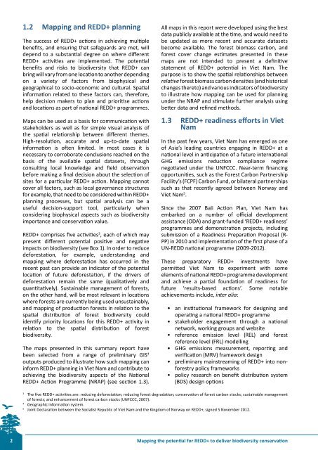
1.2 <strong>Mapping</strong> and <strong><strong>REDD</strong>+</strong> planningThe success of <strong><strong>REDD</strong>+</strong> actions in achieving multiplebenefits, and ensuring that safeguards are met, willdepend <strong>to</strong> a substantial degree on where different<strong><strong>REDD</strong>+</strong> activities are implemented. The <strong>potential</strong>benefits and risks <strong>to</strong> biodiversity that <strong><strong>REDD</strong>+</strong> canbring will vary from one location <strong>to</strong> ano<strong>the</strong>r dependingon a variety of fac<strong>to</strong>rs from biophysical andgeographical <strong>to</strong> socio-economic and cultural. Spatialin<strong>for</strong>mation related <strong>to</strong> <strong>the</strong>se fac<strong>to</strong>rs can, <strong>the</strong>re<strong>for</strong>e,help decision makers <strong>to</strong> plan and prioritise actionsand locations as part of national <strong><strong>REDD</strong>+</strong> programmes.Maps can be used as a basis <strong>for</strong> communication withstakeholders as well as <strong>for</strong> simple visual analysis of<strong>the</strong> spatial relationship between different <strong>the</strong>mes.High-resolution, accurate and up-<strong>to</strong>-date spatialin<strong>for</strong>mation is often limited. In most cases it isnecessary <strong>to</strong> corroborate conclusions reached on <strong>the</strong>basis of <strong>the</strong> available spatial datasets, throughconsulting local knowledge and field observationbe<strong>for</strong>e making a final decision about <strong>the</strong> selection ofsites <strong>for</strong> a particular <strong><strong>REDD</strong>+</strong> action. <strong>Mapping</strong> cannotcover all fac<strong>to</strong>rs, such as local governance structures<strong>for</strong> example, that need <strong>to</strong> be considered within <strong><strong>REDD</strong>+</strong>planning processes, but spatial analysis can be auseful decision-support <strong>to</strong>ol, particularly whenconsidering biophysical aspects such as biodiversityimportance and conservation value.<strong><strong>REDD</strong>+</strong> comprises five activities 3 , each of which maypresent different <strong>potential</strong> positive and negativeimpacts on biodiversity (see Box 1). In order <strong>to</strong> reducede<strong>for</strong>estation, <strong>for</strong> example, understanding andmapping where de<strong>for</strong>estation has occurred in <strong>the</strong>recent past can provide an indica<strong>to</strong>r of <strong>the</strong> <strong>potential</strong>location of future de<strong>for</strong>estation, if <strong>the</strong> drivers ofde<strong>for</strong>estation remain <strong>the</strong> same (qualitatively andquantitatively). Sustainable management of <strong>for</strong>ests,on <strong>the</strong> o<strong>the</strong>r hand, will be most relevant in locationswhere <strong>for</strong>ests are currently being used unsustainably,and mapping of production <strong>for</strong>ests in relation <strong>to</strong> <strong>the</strong>spatial distribution of <strong>for</strong>est biodiversity couldidentify priority locations <strong>for</strong> this <strong><strong>REDD</strong>+</strong> activity inrelation <strong>to</strong> <strong>the</strong> spatial distribution of <strong>for</strong>estbiodiversity.The maps presented in this summary report havebeen selected from a range of preliminary GIS 4outputs produced <strong>to</strong> illustrate how such mapping canin<strong>for</strong>m <strong><strong>REDD</strong>+</strong> planning in Viet Nam and contribute <strong>to</strong>achieving <strong>the</strong> biodiversity aspects of <strong>the</strong> National<strong><strong>REDD</strong>+</strong> Action Programme (NRAP) (see section 1.3).All maps in this report were developed using <strong>the</strong> bestdata publicly available at <strong>the</strong> time, and would need <strong>to</strong>be updated as more recent and accurate datasetsbecome available. The <strong>for</strong>est biomass carbon, and<strong>for</strong>est cover change estimates presented in <strong>the</strong>semaps are not intended <strong>to</strong> present a definitivestatement of <strong><strong>REDD</strong>+</strong> <strong>potential</strong> in Viet Nam. Thepurpose is <strong>to</strong> show <strong>the</strong> spatial relationships betweenrelative <strong>for</strong>est biomass carbon densities (and his<strong>to</strong>ricalchanges <strong>the</strong>re<strong>to</strong>) and various indica<strong>to</strong>rs of biodiversity<strong>to</strong> illustrate how mapping can be used <strong>for</strong> planningunder <strong>the</strong> NRAP and stimulate fur<strong>the</strong>r analysis usingbetter data and refined methods.1.3 <strong><strong>REDD</strong>+</strong> readiness ef<strong>for</strong>ts in <strong>VietNam</strong>In <strong>the</strong> past few years, Viet Nam has emerged as oneof Asia’s leading countries engaging in <strong><strong>REDD</strong>+</strong> at anational level in anticipation of a future internationalGHG emissions reduction compliance regimenegotiated under <strong>the</strong> UNFCCC. Near-term financingopportunities, such as <strong>the</strong> Forest Carbon PartnershipFacility’s (FCPF) Carbon Fund, or bilateral partnershipssuch as that recently agreed between Norway andViet Nam 5 .Since <strong>the</strong> 2007 Bali Action Plan, Viet Nam hasembarked on a number of official developmentassistance (ODA) and grant-funded ‘<strong><strong>REDD</strong>+</strong> readiness’programmes and demonstration projects, includingsubmission of a Readiness Preparation Proposal (R-PP) in 2010 and implementation of <strong>the</strong> first phase of aUN-<strong>REDD</strong> national programme (2009-2012).These prepara<strong>to</strong>ry <strong><strong>REDD</strong>+</strong> investments havepermitted Viet Nam <strong>to</strong> experiment with someelements of national <strong><strong>REDD</strong>+</strong> programme developmentand achieve a partial foundation of readiness <strong>for</strong>future ‘results-based actions’. Some notableachievements include, inter alia:• an institutional framework <strong>for</strong> designing andoperating a national <strong><strong>REDD</strong>+</strong> programme• stakeholder engagement through a nationalnetwork, working groups and website• reference emission level (REL) and <strong>for</strong>estreference level (FRL) modelling• GHG emissions measurement, reporting andverification (MRV) framework design• preliminary mainstreaming of <strong><strong>REDD</strong>+</strong> in<strong>to</strong> non<strong>for</strong>estrypolicy frameworks• policy research on benefit distribution system(BDS) design options3The five <strong><strong>REDD</strong>+</strong> activities are: reducing de<strong>for</strong>estation; reducing <strong>for</strong>est degradation; conservation of <strong>for</strong>est carbon s<strong>to</strong>cks; sustainable managemen<strong>to</strong>f <strong>for</strong>ests; and enhancement of <strong>for</strong>est carbon s<strong>to</strong>cks (UNFCCC, 2007).4Geographic in<strong>for</strong>mation system.5Joint Declaration between <strong>the</strong> Socialist Republic of Viet Nam and <strong>the</strong> Kingdom of Norway on <strong><strong>REDD</strong>+</strong>, signed 5 November 2012.2<strong>Mapping</strong> <strong>the</strong> <strong>potential</strong> <strong>for</strong> <strong><strong>REDD</strong>+</strong> <strong>to</strong> <strong>deliver</strong> biodiversity conservation