Hewell Grange Estate - Setting of Heritage Assets Assessment
Hewell Grange Estate - Setting of Heritage Assets Assessment
Hewell Grange Estate - Setting of Heritage Assets Assessment

Create successful ePaper yourself
Turn your PDF publications into a flip-book with our unique Google optimized e-Paper software.
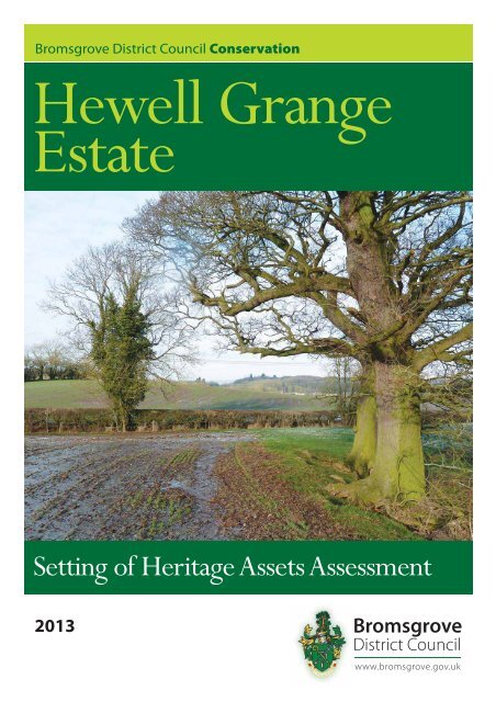
Bromsgrove District Council Conservation<strong>Hewell</strong> <strong>Grange</strong><strong>Estate</strong><strong>Setting</strong> <strong>of</strong> <strong>Heritage</strong> <strong>Assets</strong> <strong>Assessment</strong>2013
<strong>Hewell</strong> <strong>Grange</strong> <strong>Estate</strong><strong>Setting</strong> <strong>of</strong> <strong>Heritage</strong> <strong>Assets</strong><strong>Assessment</strong>2013Page | 1
9 For example, those policies relating to sites protected under the Birds and Habitats Directives(see paragraph 119) and/or designated as Sites <strong>of</strong> Special Scientific Interest; land designatedas Green Belt, Local Green Space, an Area <strong>of</strong> Outstanding Natural Beauty, <strong>Heritage</strong> Coast orwithin a National Park (or the Broads Authority); designated heritage assets; and locations atrisk <strong>of</strong> flooding or coastal erosion.Harm to heritage assets through development within their setting is assessed against thesame policies as for physical harm to the significance <strong>of</strong> designated heritage assetsgenerally. This is detailed in Paragraph 132, which states’. When considering the impact<strong>of</strong> a proposed development on the significance <strong>of</strong> a designated heritage asset, greatweight should be given to the asset’s conservation. The more important the asset, thegreater the weight should be. Significance can be harmed or lost through alteration ordestruction <strong>of</strong> the heritage asset or development within its setting. As heritage assets areirreplaceable, any harm or loss should require clear and convincing justification.Substantial harm to or loss <strong>of</strong> a grade II listed building, park or garden should beexceptional. Substantial harm to or loss <strong>of</strong> designated heritage assets <strong>of</strong> the highestsignificance, notably scheduled monuments, protected wreck sites, battlefields, grade Iand II* listed buildings, grade I and II* registered parks and gardens, and World <strong>Heritage</strong>Sites, should be wholly exceptional’ 2 .Therefore harm should be judged against the public benefits delivered by the proposal.Paragraph 133 states. Where a proposed development will lead to substantial harm to ortotal loss <strong>of</strong> significance <strong>of</strong> a designated heritage asset, local planning authorities shouldrefuse consent, unless it can be demonstrated that the substantial harm or loss isnecessary to achieve substantial public benefits that outweigh that harm or loss…’,Other paragraphs <strong>of</strong> the NPPF which need to be considered are as follows;129. Local planning authorities should identify and assess the particular significance <strong>of</strong>any heritage asset that may be affected by a proposal (including by developmentaffecting the setting <strong>of</strong> a heritage asset) taking account <strong>of</strong> the available evidence andany necessary expertise. They should take this assessment into account whenconsidering the impact <strong>of</strong> a proposal on a heritage asset, to avoid or minimise conflictbetween the heritage asset’s conservation and any aspect <strong>of</strong> the proposal.135. The effect <strong>of</strong> an application on the significance <strong>of</strong> a non-designated heritage assetshould be taken into account in determining the application. In weighing applications thataffect directly or indirectly non designated heritage assets, a balanced judgement will berequired having regard to the scale <strong>of</strong> any harm or loss and the significance <strong>of</strong> theheritage asset.2.4 PPS5 Historic Environment Practice Guide, March 20102 Definition <strong>of</strong> significance from the Glossary in the NPPFThe value <strong>of</strong> a heritage asset to this and future generations because <strong>of</strong> its heritage interest. That interest may bearchaeological, architectural, artistic or historic. Significance derives not only from a heritage asset’s physical presence,but also from its setting.Definition <strong>of</strong> <strong>Setting</strong> from the Glossary in the NPPFThe surroundings in which a heritage asset is experienced. Its extent is not fixed and may change as the asset and itssurroundings evolve. Elements <strong>of</strong> a setting may make a positive or negative contribution to the significance <strong>of</strong> an asset,may affect the ability to appreciate that significance or may be neutral.Page | 4
Although PPS 5 has been superseded by the NPPF, the Practice Guide and theprinciples detailed within it have not. The following paragraphs <strong>of</strong> this document aretherefore relevant when considering possible development within the setting <strong>of</strong> heritageassets at <strong>Hewell</strong>;2.5 Assessing the implications <strong>of</strong> change affecting setting118. Change, including development, can sustain, enhance or better reveal thesignificance <strong>of</strong> an asset as well as detract from it or leave it unaltered. For the purposes<strong>of</strong> spatial planning, any development or change capable <strong>of</strong> affecting the significance <strong>of</strong> aheritage asset or people’s experience <strong>of</strong> it can be considered as falling within its setting.Where the significance and appreciation <strong>of</strong> an asset have been compromised byinappropriate changes within its setting in the past it may be possible to enhance thesetting by reversing those changes.119. Understanding the significance <strong>of</strong> a heritage asset will enable the contribution madeby its setting to be understood. This will be the starting point for any proper evaluation <strong>of</strong>the implications <strong>of</strong> development affecting setting. The effect on the significance <strong>of</strong> anasset can then be considered and weighed-up following the principles set out in policiesHE 7, 8 and 9. While this consideration is perhaps most likely to address the addition orremoval <strong>of</strong> a visual intrusion, other factors such as noise or traffic activity and historicrelationships may also need to be considered.120. When assessing any application for development within the setting <strong>of</strong> a heritageasset, local planning authorities may need to consider the implications <strong>of</strong> cumulativechange and the fact that developments that materially detract from the asset’ssignificance may also damage its economic viability now, or in the future, therebythreatening its ongoing conservation.122. A proper assessment <strong>of</strong> the impact on setting will take into account, and beproportionate to, the significance <strong>of</strong> the asset and the degree to which proposedchanges enhance or detract from that significance and the ability to appreciate it.123. English <strong>Heritage</strong> have prepared detailed guidance on understanding the setting <strong>of</strong>heritage assets and assessing the impact <strong>of</strong> any changes affecting them and on how toassess heritage significance within views.This guidance was published in October 2011. It provides the basis for advice by English<strong>Heritage</strong> on the setting <strong>of</strong> heritage assets when they respond to consultations and whenthey assess the implications <strong>of</strong> development proposals on the historic estate that theymanage. It is also intended to assist others involved with managing development thatmay affect the setting <strong>of</strong> heritage assets.Since the publication <strong>of</strong> the National Planning Policy Framework (NPPF) in March 2012,some <strong>of</strong> the references in this document may now be out-<strong>of</strong>-date. English <strong>Heritage</strong>believes, however, that the policy approach is unlikely to change and that this documentstill contains useful advice and case studies.English <strong>Heritage</strong> are in the process <strong>of</strong> revising this Guidance:• to reflect changes resulting from the NPPF and other Government initiatives• to incorporate new information and advice based on recent case law and InquirydecisionsPage | 5
2.6 Bromsgrove District Council Local Plan Adopted January 2004The most relevant sections to proposed development at <strong>Hewell</strong> are as follows;Development In Conservation AreasS35A The District Council will seek to preserve or enhance the character or appearance<strong>of</strong> Conservation Areas and will:a) undertake measures as appropriate to promote and improve the environmental quality<strong>of</strong> such areas;b) require new development, in or adjacent to such areas, to be sympathetic to thecharacter <strong>of</strong> buildings in the detailed treatment <strong>of</strong> matters <strong>of</strong> design including the form,scale and materials;d) seek to retain and enhance open spaces, important views, trees or other features <strong>of</strong>importance to the street scene.Historic Parks And GardensS48 Planning permission or listed building consent will not be granted for developmentwhich would have an adverse effect on the character and setting <strong>of</strong> historic parks andgardens. Proposals will be assessed against their effect on:a) views into or out <strong>of</strong> the park or garden;b) vistas or sequential views within the park or garden;c) 'natural' elements such as tree belts, avenues, specimen trees, water features,ornamental gardens and plant species;d) structures, statues and garden ornaments;e) the topography <strong>of</strong> the garden;f) open spaces and their relationship to enclosures.The District Council will liaise with English <strong>Heritage</strong> and the Garden History Society inconsidering applications either within the boundaries <strong>of</strong> such parks and gardens or inproximity to them where important views from the park and/or garden would bematerially affected.12.15 Historic parks and gardens include those listed in the register <strong>of</strong> parks andgardens <strong>of</strong> special historic interest maintained by English <strong>Heritage</strong>. These are HagleyPark (Grade I) and <strong>Hewell</strong> Park (Grade II*). This policy also applies to other parks andgardens <strong>of</strong> regional importance in the District, which are indicated in Appendix 7A.2.7 The Draft Core Strategy 2 (DCS 2) (2011)The Draft Core Strategy for Bromsgrove is at an advanced stage <strong>of</strong> production, andshould progress quickly to the final stages and formal adoption. The policies in respect<strong>of</strong> the Historic Environment in DSC2 are currently being updated in response to theconsultation in 2011 but were drafted as follows;7.147 Core Policy 16Managing the Historic EnvironmentThe Council will conserve and enhance the significance, heritage interest and setting <strong>of</strong>the historic environment by:Advocating a holistic approach to the proactive management <strong>of</strong> the historicenvironment which encompasses designated and undesignated historicPage | 6
uildings, archaeology and historic landscapes including for example historicparks and gardens and those included in the National RegisterProducing character appraisals and management plans for designatedConservation Areas based on an assessment <strong>of</strong> local identity and uniqueness,and encouraging the production <strong>of</strong> Village Design Statements by the localcommunity to promote local distinctivenessStimulating and supporting the sensitive reuse <strong>of</strong> redundant historic buildings asa catalyst for regeneration and economic vitalityEnsuring opportunities are embraced to develop Green infrastructure networksthat can enhance the amenity value <strong>of</strong> the historic environment.Ensuring that applications for development respect and reflect the importance <strong>of</strong>heritage assets and their role in the local communityPromoting a positive interaction between historic sites and places and moderndevelopments which allows for evolution and positive change whilst preservingthe significance <strong>of</strong> existing assetsEncouraging high quality contemporary developments in historic areas whichstand on their own merits, rather than pastiche replicas <strong>of</strong> existing buildingsUndertaking further studies to better understand the local identity anddistinctiveness <strong>of</strong> the District, which will in turn inform local decision making andsupport the future growth <strong>of</strong> the Worcestershire Historic Environment RecordEmbracing opportunities to mitigate the effects <strong>of</strong> climate change through the use<strong>of</strong> sustainable building technologies and the use <strong>of</strong> renewable energy providing itdoes not compromise the quality <strong>of</strong> the historic building.3.0 The AreaSee Map 2The Area comprises an area <strong>of</strong> approximately 90 hectares south east <strong>of</strong> the RPG and<strong>Hewell</strong> CA. It is bounded by the RPG and CA to the north/north east, <strong>Hewell</strong> Lane to thewest, Brockhill Drive and the Brockhill <strong>Estate</strong> to the south/south east and fields to thenortheast, which lie south west <strong>of</strong> Brockhill Lane.The topography is undulating across The Area, with high points around Tack Farm andextending eastwards. There are further high points around the south west corner <strong>of</strong> thesite where <strong>Hewell</strong> Lane meets Brockhill Drive. The Batchley Brooks runs in a southeast/northwest direction in the northern part <strong>of</strong> The Area and the land here is low lyingbut reasonably level.Within The Area there are two groups <strong>of</strong> farm buildings, Tack Farm where theoutbuildings have been converted to residential use, and Oxstalls Farm which is still inagricultural use. The Area itself is in agricultural use and subdivided into a number <strong>of</strong>fields, some under crops and some used for pasture.4.0 The Development Site and the setting <strong>of</strong> the RPG and the CASee Map 2Page | 7
constructed, cutting across it. The lower part <strong>of</strong> the drive then connected to the newtrack which led directly out to <strong>Hewell</strong> Lane, approximately half way between the WaterTower and the footpath (PROW). It is still in use today running down to the Paper MillCottages and via the castellated bridge to the kennels and associated buildings.The Southern Parkland was relatively enclosed until sometime between the 1930s and1950s.The surveyor’s draft <strong>of</strong> the first Ordnance Survey map <strong>of</strong> 1813 clearly shows abelt <strong>of</strong> trees running adjacent, on the north side, to what is now the public right <strong>of</strong> way(PROW) from <strong>Hewell</strong> Lane. This screen <strong>of</strong> trees is again present on the 1884 OrdnanceSurvey Map, although it is not so dense that it would have formed an impenetrableboundary, compared to the tree planting on the Planted Hill or immediately to the southeast <strong>of</strong> the lake. At this time much <strong>of</strong> the planting around the perimeter <strong>of</strong> the RPG wasnot particularly dense. Repton was critical <strong>of</strong> some <strong>of</strong> the perimeter planting in 1812, inhis section <strong>of</strong> the Red Book 5 on ‘The Belt’ he advises the thinning <strong>of</strong> some <strong>of</strong> these treesand states ‘in some places even these (deciduous trees) should be removed entirely toadmit views <strong>of</strong> the country beyond the pale’. The following two Ordnance Survey Maps<strong>of</strong> 1904 and 1927 show little change to the trees on this southern boundary, the onlysignificant change is the development <strong>of</strong> the Cladshill Wood between 1884 and 1904,and between 1904 and 1927 the boundary <strong>of</strong> trees along <strong>Hewell</strong> Lane from ParkCottages to the public right <strong>of</strong> way appears. The belt <strong>of</strong> trees to the south <strong>of</strong> theSouthern Parkland disappears between 1927and the 1950s.4.4 The Lake and Lakeside landscape, comprise a large area <strong>of</strong> the RPG which includesthe core <strong>of</strong> the Repton and Brown landscape around the lake, but also the areasbordering the Area. These areas include the Claddshill Wood and the grassland areaseast and south east <strong>of</strong> the lake which became part <strong>of</strong> the Park in the 19 th century. Theycontain no individual parkland trees, and it is likely that there was only a scatteringoriginally. The southernmost fields feel separate from the ‘core parkland’ but form anattractive pastoral landscape. Although the boundary <strong>of</strong> the RPG is loosely screenedwith trees, the area is connected to the smaller fields with trees and hedgerows alongthe Batchley Brook, by the track which connects the kennels, which sit just outside theRPG at this point, with <strong>Hewell</strong> Lane via the castellated bridge at the foot <strong>of</strong> the Lake. TheRPG therefore merges into the rural setting beyond its boundary, in this area.4.5 The Planted Hill, is highly visible from The Area and beyond, due to the topography<strong>of</strong> the <strong>Hewell</strong> <strong>Estate</strong>. It extends as far as the track from <strong>Hewell</strong> Lane to Paper Millcottages just to the west <strong>of</strong> where it splits and the eastern track heads towards theKennels. The Landscape Agency Report describes the area as ‘a rare and valuableexample <strong>of</strong> Victorian modifications, enhancing, rather than detracting, from an earlierdesigned landscape’. These specimen trees are visible from a number <strong>of</strong> points acrossThe Area and from various points along <strong>Hewell</strong> Lane as one approaches the RPG.4.6 The wider rural environment provides the rural setting to the <strong>Hewell</strong> <strong>Estate</strong> which, asnoted above, falls under the two designations, the RPG and the CA. The landsurrounding the estate is still almost all agricultural, and this rural setting contributes tothe significance <strong>of</strong> the HAs and our understanding and appreciation <strong>of</strong> them. In the widerarea there are a number <strong>of</strong> farms and estate cottages, their existence underlying thesparsely populated rural nature <strong>of</strong> the area. The Historic Environment <strong>Assessment</strong> 65 HWRO H Repton, Red Book for <strong>Hewell</strong> <strong>Grange</strong>, January 18126 Historic Environment <strong>Assessment</strong> for Bromsgrove District Council 21 st June 2010Page | 9
describes the broader environment as having ‘a settlement pattern <strong>of</strong> farmsteads andstrings <strong>of</strong> wayside dwellings associated with a moderate to high level <strong>of</strong> dispersal’.4.7 The setting <strong>of</strong> the HAs to the south has remained relatively unaltered. The land nowcomprising The Area provides a buffer between the country <strong>Estate</strong> and the urban fringe<strong>of</strong> Redditch. There are only very limited views <strong>of</strong> the centre <strong>of</strong> Redditch and the housingat Brockhill, but there are extensive views <strong>of</strong> the edge <strong>of</strong> the RPG from the Area andfrom <strong>Hewell</strong> Lane across the site. The RPG and associated rural non designatedheritage assets are clearly viewed in a rural setting.4.8 Locating development in The Area will not only alter the character <strong>of</strong> the land itselfbut due to the topography <strong>of</strong> the site and its proximity to the HAs will obscure viewsacross the site towards the HAs, and will completely alter the views out <strong>of</strong> the HAstowards the south. The rural setting will be lost, replaced by a suburban landscape.4.9 The Area currently contributes to the significance <strong>of</strong> the HAs in forming part <strong>of</strong> therural setting <strong>of</strong> the HAs. It is the buffer between them and the outskirts <strong>of</strong> Redditch.Screening new development with trees and hedgerow will not mitigate the fact that thebuffer between the HAs and the outskirts <strong>of</strong> Redditch will be foreshortened resulting inthe loss <strong>of</strong> the setting <strong>of</strong> the HAs, and therefore detracting from their significance.5.0 ENGLISH HERITAGE SETTING ASSESSMENTAs part <strong>of</strong> this assessment, the impact <strong>of</strong> any proposed development has been assessedin accordance with the methodology outlined in the EH document, ‘<strong>Setting</strong> <strong>of</strong> <strong>Heritage</strong><strong>Assets</strong>’, (October 2011). Section 2.4 <strong>of</strong> the guidance states, ‘<strong>Setting</strong> is not a heritageasset, nor a heritage designation. Its importance lies in what it contributes to thesignificance <strong>of</strong> the <strong>Heritage</strong> Asset’. Section 2.4 further states, ‘The setting <strong>of</strong> someheritage assets may have remained relatively unaltered over a long period and closelyresemble the setting in which the asset was constructed or first used. The likelihood <strong>of</strong>this original setting surviving unchanged tends to decline with age and, where this is thecase, it is likely to make an important contribution to the heritage asset’s significance.’5.1 Assessing the impact <strong>of</strong> proposed development using the English <strong>Heritage</strong>Guidance Document, ‘The <strong>Setting</strong> <strong>of</strong> <strong>Heritage</strong> <strong>Assets</strong>’, October 2011The English <strong>Heritage</strong> methodology is set out in Section 4, <strong>Setting</strong> and DevelopmentManagement, <strong>of</strong> this document, and more specifically in sub-section 4.2, ‘Assessing theimplications <strong>of</strong> development proposals’.The methodology involves a 5 step approach as follows:Step 1 Identifying the assets affected and their settingsStep 2 assessing the contribution setting makes to significanceStep 3 assessing the effect <strong>of</strong> the proposed developmentStep 4 Maximising enhancement and minimising harmStep 5 making and documenting the decision and monitoring outcomesThe scope <strong>of</strong> this study is restricted to the impact <strong>of</strong> any possible development in TheArea, defined above, on the setting and significance <strong>of</strong> the HAs at <strong>Hewell</strong> <strong>Grange</strong>. Thissetting guidance is primarily for use when detailed development proposals are beingconsidered, but in this case acts as a useful guide for objectively considering possibledevelopment in The Area.Page | 10
Step 1 – Identifying the assets affected and their settingsThe document states ‘The starting point <strong>of</strong> the analysis is to identify those heritageassets likely to be affected by the development proposal (in this case it is possibledevelopment). For this purpose if the development is capable <strong>of</strong> affecting thecontribution <strong>of</strong> a heritage asset’s setting to its significance or the appreciation <strong>of</strong> itssignificance, it can be considered as falling within the assets setting’The two major assets here are The <strong>Hewell</strong> Conservation Area and the Registered Parkand Garden. Due to the nature <strong>of</strong> the HAs in questions it is difficult to define their settingdefinitively or precisely. Section 2.2 <strong>of</strong> the setting guidance acknowledges that ‘settingdoes not have a fixed boundary and cannot be definitively and permanently described asa spatially bounded area or as lying within a set distance <strong>of</strong> a heritage asset.’ At <strong>Hewell</strong>it is the rural landscape comprising both agricultural and forested areas surrounding theHAs, sufficient to leave the impression <strong>of</strong> the country estate forming an integral element<strong>of</strong> the countryside. In terms <strong>of</strong> the heritage assets at <strong>Hewell</strong> it would comprises almostall <strong>of</strong> The Area. This area is agricultural land with some trees and hedgerows whichforms a buffer between the HAs and the outer reaches <strong>of</strong> Redditch.Step 2: Assessing whether, how and to what degree settings make a contributionto the significance <strong>of</strong> the heritage assetsThe starting point for this stage <strong>of</strong> the assessment is to consider the significance <strong>of</strong> theheritage assets and then establish the contribution made by their setting.Significance <strong>of</strong> the RPG‘The significance <strong>of</strong> the historic landscape at <strong>Hewell</strong> arises out <strong>of</strong> its degree <strong>of</strong> survivalas a late 18 th century landscape associated with the 4 th Earl <strong>of</strong> Plymouth and ‘Capability’Brown, and more significantly the 6 th Earl <strong>of</strong> Plymouth and Humphry Repton. Thesignificance is further enhanced by the late 19 th century design, planting and extensivenew building by the 1 st Earl <strong>of</strong> Plymouth (<strong>of</strong> the second creation)’. 7The RPG at <strong>Hewell</strong> <strong>Grange</strong> (Grade II*) 8 comprises extensive pleasure groundssurrounding the mansion, designed landscape and parkland, which still containsspecimen and veteran trees dating from the earliest stages <strong>of</strong> landscaping in the 17 thcentury. Although the existing mansion was constructed between 1884 and 1891, theestate is far older, dating back to the dissolution. A former grange to Bordesley Abbey, itcame to the Windsor Family in 1542. A number <strong>of</strong> prominent garden designers <strong>of</strong> the18 th and 19 th century were associated with the Park, including William Shenstone,Capability Brown and Humphry Repton. The poet and landscape theorist WilliamShenstone was involved in a number <strong>of</strong> discussions regarding alterations to the park.There is, however, no evidence that any <strong>of</strong> his ideas were taken up. Lancelot ‘Capability’Brown and possibly Nathaniel Richmond were engaged in the 1760s primarily toredesign and enlarge the lake. Brown probably planted up the new section <strong>of</strong> road tocreate an enclosing belt to close the view beyond the lake. Humphry Repton wasconsulted early in the 19 th century and as previously mentioned produced a Red Book in1812. It would appear that he was critical <strong>of</strong> the existing landscape, and suggested ways<strong>of</strong> improving it. Many <strong>of</strong> his ideas were pursued including altering the house, addingislands to the lake, making changes to the planting and creating a number <strong>of</strong> walks. TimMowl 9 describes the landscape at <strong>Hewell</strong> as ‘a major picturesque landscape park’.7 Conservation Management Plan, <strong>Hewell</strong> <strong>Grange</strong>, Worcestershire July 2006, The Landscape Agency8 List description available at http://list.english‐heritage.org.uk/resultsingle.aspx?9 Timothy Mowl, Historic Gardens <strong>of</strong> Worcestershire (Tempus 2006) p.85Page | 11
However the park is much more extensive than these areas, and to the south <strong>of</strong> the lake,in the Southern Park, are the remains <strong>of</strong> the veteran trees associated with the 17 th and18 th parkland landscape.Further elaborate formal gardens and new access drives were created in 19 th and 20 thcenturies. Other, Sixth Earl <strong>of</strong> Plymouth, was notable for his widespread use <strong>of</strong> gardenstatuary and ornaments made from the artificial stone manufactured by Eleanor Coade,much <strong>of</strong> which remains in the gardens, and the French Garden was also developedduring his time. The new kitchen walled garden was relocated in 1827 to an area on theother side <strong>of</strong> <strong>Hewell</strong> Lane, and with the exception <strong>of</strong> glass houses, has survived almostin its entirety.The period from the 1860s to the outbreak <strong>of</strong> the First World War saw an unprecedentedlevel <strong>of</strong> expenditure on the <strong>Hewell</strong> <strong>Grange</strong> <strong>Estate</strong> with the building <strong>of</strong> the New Mansion(to designs by Bodley and Garner), listed Grade II* 10 . Alan Brookes 11 describes themansion as ‘one <strong>of</strong> the most important late 19 th century country houses in England’,Major landscaping works <strong>of</strong> this period including alterations to the French Garden, theconstruction <strong>of</strong> the sandstone water tower and the grass terraces.In 1946 the Mansion, gardens and park became the property <strong>of</strong> HM Prison Service. Theneglect <strong>of</strong> the gardens during the war years meant that much <strong>of</strong> the subtle detail <strong>of</strong> thepleasure grounds has been lost, although several features have been restored in recentyears by the Prison Service in conjunction with the Hereford and Worcester GardensTrust. Despite this neglect, the mansion, the remains <strong>of</strong> the designed landscape, themajor garden features and the Parkland still exist and are in relatively good condition.The rural setting has also largely survived, adding to the legibility <strong>of</strong> the <strong>Estate</strong> as awhole and its significance.Significance <strong>of</strong> the CAThe <strong>Hewell</strong> <strong>Grange</strong> Conservation Area comprises the immediate country estatesurrounding <strong>Hewell</strong> <strong>Grange</strong>, the Grade II* mansion. There are a number <strong>of</strong> designatedassets within the CA, including the RPG and a number <strong>of</strong> garden structures. The CA ishowever slightly larger than the RPG as it includes a number <strong>of</strong> associated <strong>Estate</strong>buildings, which were an integral part <strong>of</strong> the <strong>Estate</strong>, however due to a number <strong>of</strong> thembeing sold <strong>of</strong>f before the Mansion was listed in 1986, none <strong>of</strong> them can be considered ascurtilage listed, these include; the dairy on <strong>Hewell</strong> Lane, the kennels, the gamekeeperscottage and the game larder, all located on the edge <strong>of</strong> the Park. These buildings forman interesting group which are a tangible representation <strong>of</strong> the former workings <strong>of</strong> the<strong>Hewell</strong> <strong>Estate</strong>, a large country estate. Some, notably the kennels, gamekeepers cottageand the game larder being located on the edge <strong>of</strong> the Eestate, looking out on the ruralsurroundings. Others, such as the dairy, are located nearer to the farm buildings, andare focussed more on the core <strong>of</strong> the <strong>Estate</strong>.The CA is significant because <strong>of</strong> the high number <strong>of</strong> listed and unlisted historic <strong>Estate</strong>buildings, and the connection between the wider landscape and this built environment.As a historic entity the inter-relationship between the setting <strong>of</strong> the listed and unlistedbuildings and the Registered Historic Park is a key element <strong>of</strong> the special interest <strong>of</strong> thisConservation Area. The wider rural setting therefore clearly contributes to thesignificance <strong>of</strong> this HA.10 list description available at http://list.english-heritage.org.uk/resultsingle.aspx?uid=110016011 Alan Brooks and Nikolaus Pevsner, The Buildings <strong>of</strong> England Worcestershire (Yale University Press 2007)p.625Page | 12
The second stage <strong>of</strong> any analysis is to assess whether the setting <strong>of</strong> a heritageasset makes a contribution to its significance and the extent <strong>of</strong> that contribution.The Asset’s physical surroundingsTopographyIn terms <strong>of</strong> the southern end <strong>of</strong> the RPG and the CA the topography is undulating to thesouth <strong>of</strong> the HAs with various high points notably to the west, and as one moveseastwards the land levels out around the Batchley Brook.Land UseThe immediate surrounding land is almost all agricultural and contributes to the ruralnature <strong>of</strong> the RPG and the CA, and the sense that this is a country estate. There are asmall number <strong>of</strong> farms and estate cottages in the vicinity and their existence underpinsthe sparsely populated rural nature <strong>of</strong> the area. The Historic Environment <strong>Assessment</strong>describes the broader environment as having ‘a settlement pattern <strong>of</strong> farmsteads andstrings <strong>of</strong> wayside dwellings associated with a moderate to high level <strong>of</strong> dispersal’.To the north east <strong>of</strong> the RPG and the CA are the two prisons which have beenconstructed on what was probably originally part <strong>of</strong> the Park, and to the north west is anestate <strong>of</strong> prison <strong>of</strong>ficer housing. The design, size and infrastructure associated withthese buildings detracts from the rural feel <strong>of</strong> the immediate surrounding area to them. Itshould be noted that these buildings were constructed at a time when Governmentdepartments benefitted from Crown Immunity. The land they occupy is comparativelysmall compared to the extent <strong>of</strong> The AreaGreen Space, trees and vegetationThere is extensive green space, trees including woodland, and vegetation surroundingthe RPG and CA notably to the north west, south and east, which emphasises the ruralsetting <strong>of</strong> the <strong>Heritage</strong> <strong>Assets</strong>. It is not clear where the extent <strong>of</strong> either <strong>Heritage</strong> <strong>Assets</strong>ends in these particular areas. By contrast to the west is the B4096, <strong>Hewell</strong> Lane, whichacts as a physical boundary to the extent <strong>of</strong> both <strong>Heritage</strong> <strong>Assets</strong>. It also acts as abarrier to the more potentially intrusive A448, Bromsgrove to Redditch Highway.Openness, enclosure and boundariesThe landscaped areas <strong>of</strong> the Park, designed by Capability Brown and Repton, areenclosed partly by design, partly due to the topography <strong>of</strong> the area <strong>of</strong> Park closer to thehouse which can be described as forming a bowl around the mansion. Originally belts <strong>of</strong>trees were designed to screen the estate but not be an impenetrable barrier, evidencedby Repton’s comments in his Red Book. The Southern Park, the area to the south <strong>of</strong> thelake and the Planted Hill, is very open and visible. The predominance <strong>of</strong> the naturalboundaries results in the extent <strong>of</strong> the HAs being ill defined in many areas, leaving theouter reaches <strong>of</strong> HAs integral parts <strong>of</strong> the rural landscape, and providing a naturalsetting to the Brown and Repton landscapes.History and degree <strong>of</strong> change over timeThe area surrounding the RPG has not changed significantly in nature over the time thatthe landscaped Park has developed. It has remained a rural area with clusters <strong>of</strong> farmbuildings and <strong>Estate</strong> properties. These have become more numerous as the centurieshave passed but not to the extent that they have changed the nature <strong>of</strong> the rurallandscape. The CA incorporates some <strong>of</strong> these buildings notably, Tardebigge Court andPage | 13
Paper Mill Cottages. The only changes which do detract are, as noted above, the twoprisons to the north east and the prison <strong>of</strong>ficer housing to the north west.IntegrityDespite some changes since the Second World War, the RPG, has remainedremarkably legible, located in a landscape that equally has seen little change. The CA,which includes the RPG as well as other buildings which contribute to the larger <strong>Hewell</strong><strong>Estate</strong>, although only recently designated includes buildings which have equally alteredlittle. Overall there has been little change since Victorian times.Experience <strong>of</strong> the AssetSurrounding landscapeThe RPG and CA as a whole largely merge into and are integrated into the surrounding,almost totally rural landscape. This is particularly true at the southern end <strong>of</strong> the sitewhere the remains <strong>of</strong> the 17 th century parkland are almost indistinguishable at firstglance from the surrounding rural or agricultural landscape.Views from, towards, through, across and including the asset (See Map 3)Section 117 <strong>of</strong> the PPS5 Planning for the Historic Environment: Historic EnvironmentPlanning Practice Guide states’ The contribution that setting makes to the significancedoes not depend on there being public rights or an ability to access or experience thatsetting’. There are numerous views from, towards, through, across and including theasset.In terms <strong>of</strong> the RPG, from the southern boundary, there are views across to the fieldseast/southeast <strong>of</strong> Tack Farm and The Area (Photograph 002). From this boundary thereare views across the Southern Parkland towards the Brown/Repton landscaped areas <strong>of</strong>the RPG, where specimen trees, an indication <strong>of</strong> a designed landscape are clearlyvisible on the Planted Hill (Photograph 940), and there are glimpses <strong>of</strong> the bottom <strong>of</strong> thelake (Photograph 005). This is particularly visible in winter months. Adjacent to thefootpath and falling either side <strong>of</strong> the track to Paper Mill Cottages is the SouthernParkland ‘an important group <strong>of</strong> veteran oak and sweet chestnut are testament to theorigins <strong>of</strong> this grassland as parkland in the 17 th and 18 th centuries’, 12 which is thereforehighly visible (Photograph 939).From the high point on the footpath which forms the boundary <strong>of</strong> the RPG and the CA,there is a view to the south east <strong>of</strong> the centre <strong>of</strong> Redditch, on a clear day (Photograph932). It is very much a distant view, and there is a large buffer <strong>of</strong> countryside betweenthe Brockhill housing estate on the fringe <strong>of</strong> the town and the HAs, preserving theirimmediate rural setting and their isolation from the nearby urban area. The Church <strong>of</strong> StStephen (1853 -55) is visible and has been for over 150 years, the settlement around ithas clearly grown substantially in that time.The remaining boundary <strong>of</strong> the RPG, moving around to the south east is partiallyscreened with trees. However, in terms <strong>of</strong> the CA the boundary to the south eastincorporates two groups <strong>of</strong> buildings excluded from the RPG, but which are historicallyimportant, forming a tangible representation <strong>of</strong> the former workings <strong>of</strong> the <strong>Hewell</strong> <strong>Estate</strong>,the Paper Mill cottages and the kennel, game keepers cottage and the game larder. The12 Conservation Management Plan, <strong>Hewell</strong> <strong>Grange</strong>, Worcestershire July 2006, The Landscape AgencyPage | 14
former are partially screened, with limited views out towards The Area and inwards fromThe Area. However around the latter buildings the site is comparatively open and due tothe more level topography in this area, around the Batchley Brook, these buildings wouldbe highly visible from The Area and The Area would be highly visible from them.(Photographs 891, 892,996 & 914) At present, despite the housing at Brockhill, the rurallandscape and setting has been preserved as the houses are some distance away andare well screened by trees, which are positioned close to the houses, leaving a rurallandscape <strong>of</strong> fields and pasture in between. There is a distant view <strong>of</strong> the spire <strong>of</strong> StStephen’s in Redditch, but little indication that this church is in the middle <strong>of</strong> Redditch(Photograph 995).There are general views to the RPG across the site from <strong>Hewell</strong> Lane and just <strong>of</strong>fBrockhill Drive (photographs 871, 926, 929, 964, 968, 969 & 970)Noise, vibration and other pollutants and nuisancesAlthough <strong>Hewell</strong> Lane forms the western boundary to the RPG, CA and the Area, andthe A448 is located beyond it to the west, neither create an intrusive amount <strong>of</strong> trafficnoise.Tranquility, remoteness, wildnessThe HAs feel tranquil and remote due to the quiet rural setting. If development occurs inThe Area, this tranquillity and remoteness will be lost as the HAs will be attached tosuburban Redditch.The asset’s associative attributesCultural Associations and TraditionsThe <strong>Hewell</strong> <strong>Estate</strong> came into the ownership <strong>of</strong> the Windsor Family in 1542 and remainedone <strong>of</strong> their homes for the next 400 years, and over that time evolved into the <strong>Estate</strong> wesee today. The current mansion was designed by one <strong>of</strong> the foremost Victorianarchitectural partnerships <strong>of</strong> its day, the London firm <strong>of</strong> Bodley and Garner. The previousmansion, the remnants <strong>of</strong> which still exist having been designed by another importantarchitect <strong>of</strong> his day, Francis Smith <strong>of</strong> Warwick. As noted above the landscape is the workpredominately <strong>of</strong> Capability Brown and Humphry ReptonConclusionThe rural setting forms an important element <strong>of</strong> the significance <strong>of</strong> these HAs. Thesignificance <strong>of</strong> both the RPG, in terms <strong>of</strong> it being a country estate, and the CA, again interms <strong>of</strong> it being a country estate, incorporating a number <strong>of</strong> estate buildings, drawsheavily on its relationship with the wider landscape. It is sparsely populated countrysidewith isolated buildings, particularly to the area south east <strong>of</strong> the HAs, which forms part <strong>of</strong>The Area. The setting contributes to the legibility <strong>of</strong> a historically and aestheticallyimportant country estate, which remains remarkably intact, and therefore our ability toappreciate the significance <strong>of</strong> the RPG and the CA.The setting <strong>of</strong> the principal HAs under consideration here, the RPG and the CA haschanged little over the last century, and remains predominately rural. The integrity <strong>of</strong> theposition <strong>of</strong> the <strong>Estate</strong> is preserved by a significant buffer <strong>of</strong> agricultural land between the<strong>Estate</strong> and the urban area.Page | 15
Step 3: Assessing the effect <strong>of</strong> the proposed development on the significance <strong>of</strong>the assetsThe boundaries <strong>of</strong> The Area have been assumed as follows; ( See Map 2)The north side <strong>of</strong> The Area would probably follow the boundary <strong>of</strong> the RPG from <strong>Hewell</strong>Lane in a north easterly direction as far as Paper Mill Cottages, it would then follow theCA boundary south around the cottages, then following the joint boundary <strong>of</strong> both assetsas far the Kennels, where it follows the CA boundary to the east <strong>of</strong> the kennels. Theboundary then continues following the boundary <strong>of</strong> the RPG/CA until it heads northalong a track towards Brockhill Lane. The Area then follows the field boundary to thenorth east, until it meets another track heading north, where it follows the field boundaryto the south. When it meets another field boundary it heads east around the field, until itmeets a track,running east west. The boundary <strong>of</strong> The Area then heads east towardsthe houses at Brockhill. The boundary then heads south westerly following the back <strong>of</strong>the housing estate and then to the north west <strong>of</strong> the community woodland, until it meetsBrockhill Drive. From Brockhill Drive the boundary runs west towards the roundabout atjunction with <strong>Hewell</strong> lane, then proceeds along <strong>Hewell</strong> Lane up to the footpath adjacentto the southern boundary <strong>of</strong> the RPG.Location and siting <strong>of</strong> developmentProximity to the assetThe north side <strong>of</strong> The Area lies immediately adjacent to the southern boundary <strong>of</strong> theRPG and the CA. In terms <strong>of</strong> the RPG the area to the north <strong>of</strong> The Area comprises theSouthern Park. In addition, to the north east corner <strong>of</strong> The Area is the ‘The Lake andLakeside’ area. The Area also abuts Paper Mill Cottages, which fall into the CA where itextends south easterly away from the joint boundary with the RPG, to include thecottages. The Kennels and associated buildings located in the other CA extension areslightly to the north east.ExtentThe Area comprises approximately 90 hectares.Position in relation to landform (topography)The topography within The Area can be described as undulating. The land rises from thesouthern boundary <strong>of</strong> the RPG/CA to a ridge which runs easterly from Tack Farm whichis at a height <strong>of</strong> 140m, and 150m at the <strong>Hewell</strong> Lane end. The land then falls awaytowards the Batchley Brook, where it is 110m. There is a further ridge towards thesouth/south western end <strong>of</strong> The Area where the land again rises to 140m. This highpoint allows for clear views across the site and towards the HAs.Degree to which location will physically or visually isolate assetDeveloping The Area and therefore encroaching into the setting <strong>of</strong> the HAs, will result inthe HAs being divorced from their existing rural setting.Position in relation to key viewsKey ViewsPage | 16
‘Key views’ are the views <strong>of</strong> the HAs from a number <strong>of</strong> vantage points within The Areaand on the edge <strong>of</strong> The Area (indicated on Map 3)and views away from the HAs acrossThe Area.Towards RPG/CARPG/CA( In general)Specimen Trees (north/north east side <strong>of</strong> southern park)The LakePaper Mill CottagesThe KennelsAway from RPG/CA Housing at BrockhillCentre <strong>of</strong> RedditchTack farmSee Map 3 and photographsTowards RPGRPG/CA( In general)As The Area abuts the RPG/CA there are clear views <strong>of</strong> both, including views <strong>of</strong> thevarious groups <strong>of</strong> specimen trees at the southern end <strong>of</strong> the RPG. From the public right<strong>of</strong> way (PROW), towards the Paper Mill Cottage end, on the boundary between theRPG/CA and The Area there are views in the winter months <strong>of</strong> the bottom <strong>of</strong> the lake(approximately 250m away) where it narrows into the channel which runs under thecastellated bridge. (Photographs 940, 001 & 005)From the top <strong>of</strong> the ridge, east <strong>of</strong> Tack Farm, the RPG (Southern Park and Planted Hill)and CA are highly visible. To the south <strong>of</strong> this ridge, there are no views to thenorth/northeast <strong>of</strong> the RPG and CA, the height <strong>of</strong> the ridge blocking all views <strong>of</strong> the landbeyond. (Photograph 880)From the centre <strong>of</strong>Tthe Area, close to the ‘pond’, there are distant views <strong>of</strong> the specimentrees, and the boundary <strong>of</strong> the RPG and the CA. (Photograph 899)There are also viewsto the RPG and CA from the south west <strong>of</strong> this point near the quarry. (Photographs 885,886, 891 & 892) From the northern part <strong>of</strong> The Area there are clear views into theRPG/CA, where specimen trees can be seen, particularly from <strong>Hewell</strong> Lane, north west<strong>of</strong> Tack Farm. (photograph 871).Specimen TreesThe specimen trees to the north <strong>of</strong> the Southern Park on the Planted Hill and to the northeast in the Lake and Lakeside area <strong>of</strong> the Park are visible from a number <strong>of</strong> vantagepoints including; from along the boundary <strong>of</strong> the RPG and the CA with The Area(photographs 940, 001 & 005); north <strong>of</strong> the ridge running eastwards from Tack Farm(Photograph 871); in the centre <strong>of</strong> The Area, in the proximity <strong>of</strong> the ‘pond’ and from thetop <strong>of</strong> the ridge just to the south <strong>of</strong> the ‘pond’(photographs 899, 891, 892, 885, 886, 889,& 890); from the northern part <strong>of</strong> The Area, from south <strong>of</strong> the Batchley Brook northwardsthere are distant views <strong>of</strong> specimen trees in the Lake and Lakeside areas <strong>of</strong> the RPGwhen looking westerly/north westerly(Photograph 914); and from various vantage pointsPage | 17
along <strong>Hewell</strong> Lane and Brockhill Drive close to the roundabout, looking north andnortheast.The LakeThe lake is only visible from the north <strong>of</strong> The Area along the boundary between TheArea and the RPG and CA, adjacent to the public footpath (Photograph 005).Paper Mill CottagesGlimpses <strong>of</strong> the Paper Mill Cottages can be seen from the northern western side <strong>of</strong> thearea immediately south <strong>of</strong> the cottages within The Area (Photograph 009); there arealso glimpses <strong>of</strong> the cottages from around the Batchley Brook close to the boundary <strong>of</strong>the Area and the HAs (Photograph 919); and there are distant views across the areafrom the entrance to Oxstalls Farm at Brockhill Drive (photographs 968 & 969)The KennelsThere are views <strong>of</strong> the kennels from a number <strong>of</strong> vantage points within the Area, notably;north <strong>of</strong> the eastwards ridge from Tack Farm, just south east <strong>of</strong> Paper Mill Cottages(Photograph 899); they are just visible south <strong>of</strong> the ridge, but only from the area aroundthe entrance to Oxstalls Farm (photographs 926, 968 & 970); they are clearly visiblefrom a number <strong>of</strong> points in the centre <strong>of</strong> The Area, particularly north <strong>of</strong> the ridge near the‘pond’ and the ridge north <strong>of</strong> Oxstalls Farm Photographs 891 & 892); from just south <strong>of</strong>the Batchley Brook there are clear views northwards <strong>of</strong> the kennels due to the low lyingtopography in this area (Photograph 914); from Brockhill Drive and the entrance toOxstalls Farm.Views away from the RPGHousing at BrockhillThere are views <strong>of</strong> the housing at Brockhill from a few vantage points; about half wayalong the public right <strong>of</strong> way (PROW) which forms the boundary between the RPG/CAand The Area there are partial views in a south easterly direction <strong>of</strong> the housing atBrockhill (Photograph 932); there are views through trees towards the housing atBrockhill from the area to the south east <strong>of</strong> Tack Farm, looking north east; lookingeasterly from the environs <strong>of</strong> the Batchley Brook within the Area there are views <strong>of</strong> thehousing at Brockhill (Photograph 915). Compared to the number <strong>of</strong> views <strong>of</strong> the RPG/CAfrom <strong>Hewell</strong> Lane/Brockhill Drive there are very few <strong>of</strong> the housing at Brockhill.Views <strong>of</strong> the centre <strong>of</strong> RedditchThe centre <strong>of</strong> Redditch is only visible from a couple <strong>of</strong> vantage points. About half wayalong the PROW there are views in a south easterly direction towards the centre <strong>of</strong>Redditch. On a clear day there are views <strong>of</strong> St Stephen’s Church (1853-55).(Photograph 932) It is very much a distant view, and there is a large buffer <strong>of</strong>countryside between the Brockhill housing estate on the fringe <strong>of</strong> the town and the HAs,thus preserving their immediate rural setting and the separation from the nearby urbanarea. In addition there are limited views <strong>of</strong> the centre <strong>of</strong> Redditch from the ridgelinedirectly east <strong>of</strong> Tack Farm and from the most westerly point <strong>of</strong> the public footpath south<strong>of</strong> Tack Farm.Tack FarmPage | 18
Tack Farm, at 140m can be seen from various points; looking south/southwest from thefootpath which forms the boundary between The Area and the RPG/CA in the northwest, there are views <strong>of</strong> the Tack Farm complex <strong>of</strong> buildings (Photograph 002); there areviews <strong>of</strong> Tack Farm from the high point in the centre <strong>of</strong> The Area, just south west <strong>of</strong> thepond (Photograph 884). There are views <strong>of</strong> Tack Farm from the layby east <strong>of</strong> theroundabout at <strong>Hewell</strong> Lane and Brockhill Drive and from the entrance to Oxtalls Farm. Inaddition there are also views from just east <strong>of</strong> the Kennels.As can be seen from the photographs there are various views across The Area towardsthe HAs and various views back again, therefore any potential development in The Areawill be highly visible.The form and appearance <strong>of</strong> the developmentProminence, Dominance or conspicuousnessDue to the topography, development on large parts <strong>of</strong> The Area would be veryprominent. Some development, particularly on the north side <strong>of</strong> the ridge which runseastwards from Tack Farm, would be very dominant.Competition with and distraction from the assetDue to the natural topography <strong>of</strong> The Area development would be very distracting.Housing or other buildings are more likely to be seen rather than the HAs, whereas atpresent the agricultural land provides a background or setting to the HAs.Dimension, Scale and MassingDevelopment <strong>of</strong> any scale on this site would differ greatly to the sparse developmenttypical <strong>of</strong> <strong>Hewell</strong> as a whole, as identified in the Historic Environment <strong>Assessment</strong>, asnoted above.ProportionsN/AVisual permeability (extent to which it can be seen through)N/AMaterials (texture, colour, reflectiveness, etc)N/AArchitectural style or designN/AIntroduction <strong>of</strong> movement or activityN/ADiurnal changes or seasonal changesAt present seasonal changes are clearly discernible as The Area is comprised almostentirely <strong>of</strong> natural features. If The Area is developed, the evidence <strong>of</strong> these seasonalchanges will be removed. In addition more areas <strong>of</strong> the HAs are visible during the wintermonths, as the lack <strong>of</strong> leaf covers results in longer views into the HAs.Page | 19
Other effects <strong>of</strong> any potential developmentChange to built surroundings and spacesN/AChanges to skylineAt present there are long views across agricultural land, and depending on the direction,these views are terminated by the trees in the HAs, or the horizon, with views <strong>of</strong> otherbuildings as noted above in between. If The Area is developed there will be views <strong>of</strong>buildings and a suburbanisation <strong>of</strong> this environment.Noise, Odour, vibration, dust, etcN/ALighting effects and ‘light spill’A housing development in The Area is likely to generate a degree <strong>of</strong> light pollution whichcurrently does not exist as this site is undeveloped agricultural land.Change to general character (eg suburbanising or industrialising)Clearly the development <strong>of</strong> this site will result in a change from a rural landscape to asuburban one.Changes to public access, use or amenityA PROW passes through The Area (define on a map), a further PROW gives access toThe Area and the community woodland (land to the south west <strong>of</strong> The Area andsoutheast <strong>of</strong> the houses at Brockhill), to which there is public access There is thereforemuch public access to The Area and it is visible from a number <strong>of</strong> public vantage points.Although public access may be maintained to these footpaths, the experience gained,from walking along them, <strong>of</strong> passing through a rural environment, the obvious setting <strong>of</strong>a country <strong>Estate</strong>, will be lost and replaced with the experience <strong>of</strong> walking through asuburban one. This will clearly undermine the experience <strong>of</strong> the country estate and theHAs from these vantage points.Change to land use and land cover: tree coverAs already outlined, a change in land use to potential residential development wouldhave a fundamental adverse impact on the setting <strong>of</strong> the HAs, even if the number <strong>of</strong>trees on the site remained the same.Changes to archaeological context, soil chemistry, or hydrologyN/AChanges to communication/accessibility/permeabilityN/APermanence <strong>of</strong> the developmentAnticipated lifetime/temporarinessIt is anticipated that development would be permanent.Page | 20
RecurrenceN/AReversibilityThe development is likely to be irreversibleLonger term or consequential effects <strong>of</strong> the developmentThe attributes outlined in the EH document are changes to ownership arrangements,economic and social viability and communal use and social viability. These attributes arenot perceived as impacting greatly on the setting <strong>of</strong> the HAs.Step 4: Maximising enhancement and minimising harmThe EH document notes that ‘Maximum advantage can be secured if any effects on thesignificance <strong>of</strong> a heritage asset arising from development liable to affect its setting areconsidered from the projects inception’. In addition it is further stated that ‘Earlyassessment <strong>of</strong> setting may provide a basis for agreeing the scope and form <strong>of</strong>development, reducing the potential for disagreement and challenge later in theprocess’. As application stage has not been reached yet in respect <strong>of</strong> any developmentwithin The Area, there is still time to consider, in light <strong>of</strong> the above analysis, whetheranother site maybe more appropriateMaximising enhancementThe EH document notes that ‘Enhancement maybe achieved by actions including:removing or remodelling an intrusive building or feature; replacement <strong>of</strong> a detrimentalfeature by a new and more harmonious one; restoring or revealing a lost historic feature;introducing new views (including glimpses or better framed views) that add to the publicexperience <strong>of</strong> the asset: or improving public access to, or interpretation <strong>of</strong>, the assetincluding its setting’. Extensive development <strong>of</strong> The Area would not enhance the setting<strong>of</strong> the HAs.Minimising harmThe EH document notes that ‘options for reducing the harm arising from developmentsmay include the relocation <strong>of</strong> a development or its elements, changes to its design, thecreation <strong>of</strong> effective long-term visual or acoustic screening, or management measuressecured by planning conditions or legal agreements’. In addition it states ‘ For somedevelopments affecting setting, the design <strong>of</strong> a development may not be capable <strong>of</strong>sufficient adjustment to avoid or significantly reduce the harm, for example whereimpacts are caused by fundamental issues such as the proximity, location, scale,prominence or noisiness <strong>of</strong> a development’.Although the topography <strong>of</strong> The Area is undulating, having assessed the topography andsightlines in detail, to and from the southern boundary <strong>of</strong> the RPG and the CA, it isconsidered that any development in The Area would intrude into the setting <strong>of</strong> both<strong>Heritage</strong> <strong>Assets</strong>.Step 5 – making and documenting the decision and monitoring outcomes.The EH document notes that ‘Broad guidance on weighing the degree <strong>of</strong> harm to thesignificance <strong>of</strong> a heritage asset against the benefits <strong>of</strong> changes, including developmentaffecting setting is provided in policies HE8, HE9 and HE10 <strong>of</strong> PPS5 (now supersededby Paragraphs 129 to 135 <strong>of</strong> the NPPF) and in paragraphs 83 to 95 <strong>of</strong> its (PPS5)Page | 21
Practice Guide. These policies provide the basis for decision making by local planningauthorities’. In addition Policy HE 9.2 is quoted, ‘where development affecting thesetting <strong>of</strong> a designated asset results in substantial harm to significance, it can bejustified only if it delivers substantial public benefits that outweigh that harm. This sectionhas been superseded by Paragraphs 132 and 133 <strong>of</strong> the NPPF. Paragraph 132 states’Significance can be harmed or lost through alteration or destruction <strong>of</strong> the heritage assetor development within its setting. As heritage assets are irreplaceable, any harm or lossshould require clear and convincing justification’. Further, ‘Substantial harm to or loss <strong>of</strong>designated heritage assets <strong>of</strong> the highest significance, notably scheduled monuments,protected wreck sites, battlefields, grade I and II* listed buildings, grade I and II*registered parks and gardens, and World <strong>Heritage</strong> Sites, should be wholly exceptional.’Paragraph 133 states, ‘Where a proposed development will lead to substantial harm toor total loss <strong>of</strong> significance <strong>of</strong> a designated heritage asset, local planning authoritiesshould refuse consent, unless it can be demonstrated that the substantial harm or loss isnecessary to achieve substantial public benefits that outweigh that harm or loss.’Having considered the above statements it is concluded that any major development inThe Area, which has remained the relatively unaltered southern setting <strong>of</strong> the RPG andCA, would cause substantial harm to these heritage assets. In deciding whether the landshould be allocated for future development, it has to be considered if the harm isnecessary to achieve public benefit, and whether that public benefit outweighs the harmto the significance <strong>of</strong> the HAs. The public benefit has to be measured against theimportance <strong>of</strong> the assets, in this case there are two, the CA and the RPG (listed GradeII*), and one <strong>of</strong> the overriding objectives <strong>of</strong> the NPPF is to conserve irreplaceableheritage assets.ConclusionCarrying out the English <strong>Heritage</strong> Five step assessment methodology detailed in theGuidance document, ‘The <strong>Setting</strong> <strong>of</strong> <strong>Heritage</strong> <strong>Assets</strong>, has provided specific evidenceand analysis <strong>of</strong> that evidence, which demonstrates both the significance <strong>of</strong> the setting incontributing to the significance <strong>of</strong> the RPG and the CA, and the substantial harm thatdevelopment <strong>of</strong> The Area will have on the setting <strong>of</strong> the designated HAs.5.0 CONCLUSIONSThe Area is located immediately adjacent to two designated heritage assets, the <strong>Hewell</strong>Conservation Area and the <strong>Hewell</strong> <strong>Grange</strong> RPG (Grade II*) and would be within thesetting <strong>of</strong> both. The significance <strong>of</strong> both assets and their setting has been outlinedabove.National planning policy requires that any harm or loss to the significance <strong>of</strong> designatedheritage assets requires clear and convincing justification. Substantial harm to or loss <strong>of</strong>designated assets <strong>of</strong> the highest significance, including a Grade II* RPG, should bewholly exceptional (Paragraph 132).The analysis carried out in this document has demonstrated that development in TheArea would cause substantial harm to the significance and setting <strong>of</strong> major assets. TheArea should therefore not be allocated.Page | 22
PHOTOGRAPHS OF VIEWS940 View looking north from public footpath across the Southern parkland939 View looking north from public footpath across the Southern parkland towards thespecimen trees on the planted Hill, veteran trees to the right.Page | 23
002 View <strong>of</strong> Tack Farm from the boundary <strong>of</strong> the RPG and The Area.932 View from the highpoint on the public footpath, <strong>of</strong>f <strong>Hewell</strong> Lane, looking easttowards Redditch and the housing at Brockhill.Page | 24
001 View from the boundary <strong>of</strong> the RPG and The Area looking north over the SouthernParkland, with the Planted Hill in the background.005 View from the footpath on the boundary <strong>of</strong> The Area and the RPG <strong>of</strong> the southernend <strong>of</strong> the lakePage | 25
864 View looking south east from the castellated bridge009 View <strong>of</strong> Paper Mill Cottages from the boundary <strong>of</strong> the CA and The Area.Page | 26
871 View from the same location looking north towards the RPG, specimen trees on thePlanted Hill beyond the Southern Parkland and in the Lakeside area, clearly visible870 View <strong>of</strong> the centre <strong>of</strong> Redditch and the Brockhill housing from the layby between thesouth eastern boundary <strong>of</strong> the RPG and Tack Farm.Page | 27
880 View north east from the electricity sub station on <strong>Hewell</strong> Lane, Tack Farm to the leftand on the horizon specimen trees in the Lake side area.964 View north east across The Area from close to the roundabout at Brockhill Drive,specimen trees on the Planted Hill and on the Lakeside just visible.Page | 28
926 North westerly view across the site from the entrance to Oxtalls Farm at BrockhillDrive, Tack Farm and specimen trees on Planted Hill and Lakeside just visible.929 Zoomed shot <strong>of</strong> the above, showing the specimen trees on the Planted HillPage | 29
968 Northerly view across the site from the entrance to Oxtalls Farm at Brockhill Drive,specimen trees on Planted Hill and Lakeside just visible969 Zoomed shot <strong>of</strong> the above showing Paper Mill CottagesPage | 30
970 From the same location as 968 but towards the Gamekeepers Cottage and kennels922 View from the community wood, Oxtalls Farm visible to north east. Illustrates howhigh the land is in this areaPage | 31
885 View south east <strong>of</strong> Tack Farm looking northerly towards RPG, specimen treesvisible886 View south east <strong>of</strong> Tack Farm looking northerly towards RPG, specimen treesvisible (zoomed shot)Page | 32
884 View south east <strong>of</strong> Tack Farm, looking north west, below the ridgePage | 33
890 View looking north west from west <strong>of</strong> the quarry. Specimen trees on the Planted Hillvisible889 View looking north west from west <strong>of</strong> the quarry. Specimen trees on the Planted Hillvisible (zoomed shot)Page | 34
892 View from west <strong>of</strong> the quarry looking north towards the game keepers cottage,game larder and kennels, specimen trees in lake side visible behind.891 View from west <strong>of</strong> the quarry looking north towards the game keepers cottage,game larder and kennels, specimen trees in lake side visible behind (zoomed shot)Page | 35
899 view from north <strong>of</strong> the quarry, looking north towards the gamekeepers cottage,game larder and kennels, with specimen trees in the background.919 Distant view <strong>of</strong> Paper Mill Cottages from south <strong>of</strong> Batchley BrookPage | 36
914 View from the centre <strong>of</strong> the site, south <strong>of</strong> Batchley brook (see Map) looking northwest. Game keepers Cottage etc visible, specimen trees to left andCladshill Wood to right.915 Opposite direction to above and view <strong>of</strong> the housing at BrockhillPage | 37
996 view looking south/southeast from the kennels, showing thin screen <strong>of</strong> trees eitherside <strong>of</strong> the Batchley Brook and the land rising beyond towards OxtallsFarm and Tack Farm995 View from the kennels towards the centre <strong>of</strong> Redditch, Spire <strong>of</strong> St Stephen’s justvisible in the centrePage | 38
Alcester Road<strong>Hewell</strong> Map 1<strong>Hewell</strong> <strong>Grange</strong>Registered Park and Gardenand Conservation Area<strong>Hewell</strong>High House LaneGypsy LaneSalter's LaneCur Lane<strong>Hewell</strong> <strong>Grange</strong> RegisteredHistoric Park and Garden<strong>Hewell</strong> <strong>Grange</strong> ConservationArea BoundaryLocal Authority BoundaryBromsgrove Road
Alcester Road<strong>Hewell</strong> Map 3<strong>Hewell</strong> <strong>Grange</strong>Registered Park and Garden,Conservation Area, The Areaand Views<strong>Hewell</strong>High House Lane996995940 939002864001 005 009932919914899915Gypsy Lane871870884885/886891/889/ 892890922Salter's Lane880964 968/969/926/ 970929922<strong>Hewell</strong> <strong>Grange</strong> RegisteredHistoric Park and Garden<strong>Hewell</strong> <strong>Grange</strong> ConservationArea BoundaryViewsCur LaneBromsgrove RoadThe AreaLocal Authority Boundary
Appendix 1Listed Buildings within the Registered Park and Garden and ConservationArea BoundaryHMP <strong>Hewell</strong> <strong>Grange</strong> (Grade II*)Ruins <strong>of</strong> the Old Hall (Grade II)Tennis Court (Grade II)South and North Lodges at NW entrance (Grade II)Water Tower (Grade II)Four coade stone statues in French garden (Grade II)Gate and gate piers at SE entrance to French garden (Grade II)Statue <strong>of</strong> Fallen Gladiator in forecourt (Grade II)Wall around forecourt N <strong>of</strong> <strong>Hewell</strong> <strong>Grange</strong> (Grade II)Icehouse 25m north <strong>of</strong> <strong>Hewell</strong> <strong>Grange</strong> (Grade II)Swing door and portal 25m NE <strong>of</strong> <strong>Hewell</strong> <strong>Grange</strong> (Grade II)Garden temple 50m NE <strong>of</strong> <strong>Hewell</strong> <strong>Grange</strong> (Grade II)Home Farmhouse (now <strong>Hewell</strong> House) (Grade II)Curtilage listed structures within the Registered park and Garden and Conservation AreaBoundaryWalled kitchen garden including the Apple Store, Gardeners Houseand historic stores and glasshouses within the garden, HolyoakesLaneStables to <strong>Hewell</strong> <strong>Grange</strong>Dovecote to rear <strong>of</strong> <strong>Hewell</strong> <strong>Grange</strong>Remains <strong>of</strong> Boat House, <strong>Hewell</strong> LakeStone seat and fountain in Quarry Gardens, <strong>Hewell</strong> ParkStone bridge leading to Tennis Court, <strong>Hewell</strong> ParkIron Bridge to Island, <strong>Hewell</strong> ParkLarge urn and plinth to S <strong>of</strong> Tennis Court, <strong>Hewell</strong> ParkStone arch and garden bridge to S <strong>of</strong> Tennis Court, <strong>Hewell</strong> ParkHa-ha with remains <strong>of</strong> stone wall, <strong>Hewell</strong> ParkSmall cast iron bridge to S <strong>of</strong> Tennis Court, <strong>Hewell</strong> ParkSteps to S <strong>of</strong> Tennis Court leading to Dutch Garden, <strong>Hewell</strong> ParkLarge cast iron bridge to N <strong>of</strong> lake, <strong>Hewell</strong> ParkCast iron gates, stone piers and brick walls to S <strong>of</strong> French Garden,<strong>Hewell</strong> ParkFountain in French Garden, <strong>Hewell</strong> ParkStone steps leading up from French GardenStone steps to W <strong>of</strong> formal garden leading to tennis lawn, <strong>Hewell</strong>ParkStone steps to E <strong>of</strong> <strong>Hewell</strong> <strong>Grange</strong> leading to rear garden, <strong>Hewell</strong>ParkArched sandstone bridge to weir, <strong>Hewell</strong> ParkStone garden steps nr lake weir, linking road to upper path, <strong>Hewell</strong> ParkUnlisted heritage assets within the Conservation AreaTardebigge PH, <strong>Hewell</strong> LanePage | 39
South West Lodge, <strong>Hewell</strong> LaneDairy Cottage, <strong>Hewell</strong> LaneSawmill House, <strong>Hewell</strong> Lane1, 2 and 3 Rose Cottages, <strong>Hewell</strong> CloseNew Cottage, <strong>Hewell</strong> CloseThe Old Forge, <strong>Hewell</strong> LaneTardebigge Court, <strong>Hewell</strong> Lane (former Home Farm)<strong>Hewell</strong> House, <strong>Hewell</strong> Lane1-4 Park Cottages, <strong>Hewell</strong> Lane<strong>Hewell</strong> Kennels, Gamekeepers Lodge and Gamekeepers Larder,<strong>Hewell</strong> LaneOld Papermill Cottage, <strong>Hewell</strong> Lane1-6 Papermill Cottages, <strong>Hewell</strong> LanePapermill Lodge, <strong>Hewell</strong> LanePage | 40
We will consider reasonable requests toprovide this document in accessible formats such aslarge print, Braille, Moon, audio CDor tape or on computer CDBromsgrove DistrictCouncilhead <strong>of</strong>planning and regenerationthe council house,burcot lane,bromsgrove b60 1aa