

Final Program - ISPRS
Final Program - ISPRS
Final Program - ISPRS

You also want an ePaper? Increase the reach of your titles
YUMPU automatically turns print PDFs into web optimized ePapers that Google loves.
34th International Symposium on Remote Sensing of Environment<br />
The GEOSS Era: Towards Operational Environmental Monitoring<br />
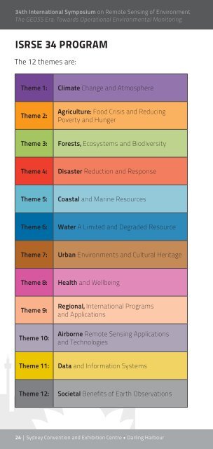
ISRSE 34 PROGRAM<br />
The 12 themes are:<br />
Theme 1: Climate Change and Atmosphere<br />
Theme 2:<br />
Agriculture: Food Crisis and Reducing<br />
Poverty and Hunger<br />
Theme 3: Forests, Ecosystems and Biodiversity<br />
Theme 4: Disaster Reduction and Response<br />
Theme 5: Coastal and Marine Resources<br />
Theme 6: Water A Limited and Degraded Resource<br />
Theme 7: Urban Environments and Cultural Heritage<br />
Theme 8: Health and Wellbeing<br />
Theme 9:<br />
Theme 10:<br />
Regional, International <strong>Program</strong>s<br />
and Applications<br />
Airborne Remote Sensing Applications<br />
and Technologies<br />
Theme 11: Data and Information Systems<br />
Theme 12: Societal Benefits of Earth Observations<br />
24 | Sydney Convention and Exhibition Centre • Darling Harbour
34TH ISRSE TECHNICAL SESSION SUMMARY<br />
ISRSE34<br />
1 CLIMATE CHANGE AND ATMOSPHERE<br />
TS-2 1-O-1 Climate Missions and Instruments Monday 14:00–15:30 Parkside 110a<br />
TS-9 1-O-2 Aerosols, Trace Gases and Air Quality Monday 16:00–17:30 Parkside 110a<br />
TS-19 1-O-3 Phenology, Seasonality and Satellite Time Series Tuesday 11:00–12:30 G04 (Ground Level)<br />
TS-40 1-O-4 Land Surface 1: Monitoring Carbon Dynamics & Emissions Wednesday 11:00–12:30 G04 (Ground Level)<br />
TS-54 1-O-5 Trends Wednesday 16:00–17:30 G04 (Ground Level)<br />
TS-67 1-O-6 Biomass Burning: New Perspectives on Quantitative Characterization (2) Smoke Emissions Thursday 11:00–12:30 Parkside 110a<br />
TS-84 1-O-7 Weather & Forecasting Thursday 16:00–17:30 G04 (Ground Level)<br />
TS-22 1-E-1 Weather, Forecasting & Aerosols Tuesday 11:00–12:30 Location 2 (Level 1)<br />
TS-36 1-E-2 Land Surface 2: Climate & Trends Tuesday 16:00–17:30 Location 2 (Level 1)<br />
TS-63 1-E-3 Land Surface 3: Vegetation & Radiation Thursday 08:30–10:30 Location 1 (Level 1)<br />
2 AGRICULTURE: FOOD CRISIS AND REDUCING POVERTY AND HUNGER<br />
TS-38 2-O-1 Crop Identification, Forecasting & Stress Detection Wednesday 11:00–12:30 Parkside 110a<br />
TS-62 2-O-2 Monitoring Water Usage, Irrigation & Drought Thursday 08:30–10:30 G05 (Ground Level)<br />
TS-70 2-O-3 Integrating Remote Sensing & Models for Agriculture & Environmental Management Thursday 11:00–12:30 G05 (Ground Level)<br />
TS-78 2-O-4 Soil Information from Remotely Sensed Data Thursday 14:00–15:30 G05 (Ground Level)<br />
TS-85 2-O-5 Mapping & Monitoring Erosion, Desertification & Land Degradation Thursday 16:00–17:30 G05 (Ground Level)<br />
TS-49 2-E-1 Agricultural Estimation & Prediction Using Remote Sensing Wednesday 14:00–15:30 Location 1 (Level 1)<br />
TS-57 2-E-2 Assessing Climate Impact & Water Usage Wednesday 16:00–17:30 Location 2 (Level 1)<br />
10 – 15 April, 2011 • www.isrse34.org | 25
34th International Symposium on Remote Sensing of Environment<br />
The GEOSS Era: Towards Operational Environmental Monitoring<br />
3 FORESTS, ECOSYSTEMS AND BIODIVERSITY<br />
TS-1 3-O-1 Ecosystem Function in Savannas: Measurement & Modelling at Landscape to Global Scales Monday 14:00–15:30 Parkside Auditorium<br />
TS-8 3-O-2 Ecosystem Function in Savannas: Australian Savannas & Woody Measurement Monday 16:00–17:30 Parkside Auditorium<br />
TS-16 3-O-3 Forests & Forest Management Tuesday 11:00–12:30 Parkside Auditorium<br />
TS-23 3-O-4 Vegetation Structure & Physiology 1 Tuesday 14:00–15:30 Parkside Auditorium<br />
TS-30 3-O-5 Vegetation Structure & Physiology 2 Tuesday 16:00–17:30 Parkside Auditorium<br />
Wednesday 11:00–12:30 Parkside Auditorium<br />
Long-term Monitoring of Terrestrial Ecosystems Globally with Landsat, AVHRR, MODIS,<br />
SPOT & Other Sensors<br />
TS-37 3-O-6<br />
TS-44 3-O-7 Mapping & Monitoring Land Use, Land Cover & Ecosystems Wednesday 14:00–15:30 Parkside Auditorium<br />
TS-51 3-O-8 Mapping Forest Cover & Biomass Wednesday 16:00–17:30 Parkside Auditorium<br />
TS-58 3-O-9 GEO Forest Carbon Tracking Product Development Thursday 08:30–10:30 Parkside Auditorium<br />
TS-66 3-O-10 Mapping Ecosystems in Australia Thursday 11:00–12:30 Parkside Auditorium<br />
TS-81 3-O-11 Forest Change Thursday 16:00–17:30 Parkside Auditorium<br />
TS-28 3-E-1 Landscape Dynamics & Conservation Tuesday 14:00–15:30 Location 1 (Level 1)<br />
TS-35 3-E-2 Land Use & Land Cover Change Tuesday 16:00–17:30 Location 1 (Level 1)<br />
TS-56 3-E-3 Forest & Vegetation Monitoring Wednesday 16:00–17:30 Location 1 (Level 1)<br />
26 | Sydney Convention and Exhibition Centre • Darling Harbour<br />
TS-71 3-E-4 Vegetation Mapping 1: Identification & Distribution Thursday 11:00–12:30 Location 1 (Level 1)<br />
TS-79 3-E-5 Modelling Vegetation Characteristics Thursday 14:00–15:30 Location 1 (Level 1)<br />
TS-86 3-E-6 Vegetation Mapping 2: Cover & Structure Thursday 16:00–17:30 Location 1 (Level 1)
4 DISASTER REDUCTION AND RESPONSE<br />
TS-60 4-O-1 Flood Monitoring & Assessment Thursday 08:30–10:30 Parkside 110b<br />
Biomass Burning: New Perspectives on Quantitative Characterization (3) Fire Danger,<br />
TS-75 4-O-2<br />
Thursday 14:00–15:30 Parkside 110a<br />
Forecasting & Post-burn Analysis<br />
TS-83 4-O-3 Geohazard Assessment & Mapping Thursday 16:00–17:30 Parkside 110b<br />
TS-14 4-E-1 Information Systems for Predicting & Responding to Disasters Monday 16:00–17:30 Location 2 (Level 1)<br />
ISRSE34<br />
Biomass Burning: New Perspectives on Quantitative Characterization (5) Forecasting &<br />
TS-21 4-E-2<br />
Tuesday 11:00–12:30 Location 1 (Level 1)<br />
Monitoring<br />
TS-50 4-E-3 Remote Sensing of Natural & Man-made Disasters Wednesday 14:00–15:30 Location 2 (Level 1)<br />
5 COASTAL AND MARINE RESOURCES<br />
TS-18 5-O-1 Phytoplankton Dynamics & Operational Oceanography Tuesday 11:00-12:30 Parkside 110b<br />
TS-25 5-O-2 Shallow Water Habitats in Temperate Environments: Bathymetry & Sun Glint Tuesday 14:00-15:30 Parkside 110b<br />
TS-46 5-O-3 Tropical Environments: Coral Reefs & Seagrass Meadows Wednesday 14:00-15:30 Parkside 110b<br />
TS-76 5-O-4 Water Quality & Ocean Colour Thursday 14:00-15:30 Parkside 110b<br />
TS-7 5-E-1 Remote Sensing of Water Features Monday 14:00-15:30 Location 2 (Level 1)<br />
TS-42 5-E-2 Mapping & Monitoring the Coastlal Zone & Coastlines Wednesday 11:00-12:30 Location 1 (Level 1)<br />
TS-64 5-E-3 Tropical Environments: Coral Reefs, Seagrass Beds & Mangroves Thursday 08:30-10:30 Location 2 (Level 1)<br />
10 – 15 April, 2011 • www.isrse34.org | 27
34th International Symposium on Remote Sensing of Environment<br />
The GEOSS Era: Towards Operational Environmental Monitoring<br />
6 WATER: A LIMITED AND DEGRADED RESOURCE<br />
TS-11 6-O-1 Hydrologic Remote Sensing: Missions & Applications 1 Monday 16:00–17:30 G04 (Ground Level)<br />
TS-32 6-O-2 Hydrologic Remote Sensing: Missions & Applications 2 Tuesday 16:00–17:30 Parkside 110b<br />
TS-39 6-O-3 Inland Water Bodies & Wetlands Wednesday 11:00–12:30 Parkside 110b<br />
TS-53 6-O-4 Inland Water Quality Wednesday 16:00–17:30 Parkside 110b<br />
TS-43 6-E-1 Hydrologic Remote Sensing: Missions & Applications 3 Wednesday 11:00–12:30 Location 2 (Level 1)<br />
TS-72 6-E-2 Wetlands Thursday 11:00–12:30 Location 2 (Level 1)<br />
TS-87 6-E-3 Inland Water Bodies Thursday 16:00–17:30 Location 2 (Level 1)<br />
7 URBAN ENVIRONMENTS AND CULTURAL HERITAGE<br />
TS-5 7-O-1 Enhanced Detection & Urban Mapping Monday 14:00–15:30 G05 (Ground Level)<br />
TS-12 7-O-2 Urban Domes, Carbon, Climate & Environment Monday 16:00–17:30 G05 (Ground Level)<br />
TS-61 7-O-3 Urban Heat Islands and Hazards Thursday 08:30–10:30 G04 (Ground Level)<br />
28 | Sydney Convention and Exhibition Centre • Darling Harbour<br />
TS-29 7-E-1 Urban Remote Sensing Tuesday 14:00–15:30 Location 2 (Level 1)<br />
8 HEALTH AND WELLBEING<br />
TS-34 8-O-1 Remote Sensing Uses in Public Health Tuesday 16:00–17:30 G05 (Ground Level)<br />
TS-13 8-E-1 Societal & Public Health Benefits of Remote Sensing Monday 16:00–17:30 Location 1 (Level 1)
9 REGIONAL, INTERNATIONAL PROGRAMS AND APPLICATIONS<br />
TS-3 9-O-1 Global Systems Monday 14:00–15:30 Parkside 110b<br />
TS-17 9-O-2 Regional Land Mapping & Monitoring Tuesday 11:00–12:30 Parkside 110a<br />
TS-26 9-O-3 ESA-MOST China Dragon 2 <strong>Program</strong>: 1. Atmospheric & Marine Applications Tuesday 14:00–15:30 G04 (Ground Level)<br />
TS-33 9-O-4 ESA-MOST China Dragon 2 <strong>Program</strong>: 2. Land Applications Tuesday 16:00–17:30 G04 (Ground Level)<br />
TS-45 9-O-5 Ground Observation Networks & Land Product Validation 1 Wednesday 14:00–15:30 Parkside 110a<br />
TS-52 9-O-6 Ground Observation Networks & Land Product Validation 2 Wednesday 16:00–17:30 Parkside 110a<br />
ISRSE34<br />
Biomass Burning: New Perspectives on Quantitative Characterization (4) Operational<br />
TS-82 9-O-7<br />
Thursday 16:00–17:30 Parkside 110a<br />
Systems & Regional Applications<br />
TS-15 9-E-1 Geological Applications of Remote Sensing Monday 16:00–17:30 Location 3 (Level 1)<br />
TS-80 9-E-2 Global & Regional Systems Thursday 14:00–15:30 Location 2 (Level 1)<br />
10 AIRBORNE REMOTE SENSING APPLICATIONS AND TECHNOLOGIES<br />
TS-4 10-O-1 Airborne Education & Outreach Monday 14:00-15:30 G04 (Ground Level)<br />
TS-10 10-O-2 <strong>ISPRS</strong> TC I Working Group I/1 Monday 16:00-17:30 Parkside 110b<br />
TS-20 10-O-3 Airborne Science Applications 1 Tuesday 11:00-12:30 G05 (Ground Level)<br />
TS-27 10-O-4 Airborne <strong>Program</strong>s: International & National Tuesday 14:00-15:30 G05 (Ground Level)<br />
TS-41 10-O-5 Unmanned Aerial Systems 1 Wednesday 11:00-12:30 G05 (Ground Level)<br />
TS-48 10-O-6 Unmanned Aerial Systems 2 Wednesday 14:00-15:30 G05 (Ground Level)<br />
TS-55 10-O-7 Unmanned Aerial Systems 3 Wednesday 16:00-17:30 G05 (Ground Level)<br />
TS-65 10-E-1 Airborne Science Applications 2 Thursday 08:30-10:30 Location 3 (Level 1)<br />
TS-73 10-E-2 Airborne Science Applications 3 Thursday 11:00-12:30 Location 3 (Level 1)<br />
10 – 15 April, 2011 • www.isrse34.org | 29
34th International Symposium on Remote Sensing of Environment<br />
The GEOSS Era: Towards Operational Environmental Monitoring<br />
11 DATA AND INFORMATION SYSTEMS<br />
TS-24 11-O-1 Missions & Instruments Tuesday 14:00–15:30 Parkside 110a<br />
TS-31 11-O-2 National Data & <strong>Program</strong>s Tuesday 16:00–17:30 Parkside 110a<br />
TS-47 11-O-3 Interoperability & Standards Wednesday 14:00–15:30 G04 (Ground Level)<br />
Biomass Burning: New Perspectives on Quantitative Characterization (1) Measurement,<br />
TS-59 11-O-4<br />
Thursday 08:30–10:30 Parkside 110a<br />
Analysis & Validation<br />
TS-69 11-O-5 Novel Information Extraction Algorithms Thursday 11:00–12:30 G04 (Ground Level)<br />
TS-77 11-O-6 Advanced Web Development Thursday 14:00–15:30 G04 (Ground Level)<br />
TS-6 11-E-1 Data Processing & Algorithms Monday 14:00–15:30 Location 1 (Level 1)<br />
TS-88 11-E-2 Missions, Instruments, Information Systems & Data Standards Thursday 16:00–17:30 Location 3 (Level 1)<br />
12 SOCIETAL BENEFITS OF EARTH OBSERVATION<br />
TS-68 12-O-1 Remote Sensing: Users, Priorities & Challenges Thursday 11:00–12:30 Parkside 110b<br />
TS-74 12-O-2 Thrilling Imagery & the Science of Design: Engaging the Public with Remote Sensing Thursday 14:00–15:30 Parkside Auditorium<br />
Electronic sessions, coded x-E-y, are more informal presentations<br />
to smaller audiences using the ePresenter system. These<br />
sessions are held at Locations 1, 2 and 3 on Level 1 (see page 23).<br />
Electronic presentations can also be viewed at these locations<br />
at other times during the Symposium, whenever the ePresenter<br />
systems are not in use.<br />
All technical sessions in the program booklet are coded as x-E-y<br />
or x-O-y where x indicates the theme and y indicates the session<br />
number within the theme.<br />
30 | Sydney Convention and Exhibition Centre • Darling Harbour<br />
Oral sessions are coded x-O-y. These conventional sessions<br />
are held in the five session rooms shown on the floor plan<br />
(see pages 22–23).
ISRSE34<br />
10 – 15 April, 2011 • www.isrse34.org | 31
MONDAY 11 APRIL 2011<br />
34th International Symposium on Remote Sensing of Environment<br />
The GEOSS Era: Towards Operational Environmental Monitoring<br />
PROGRAM AT A GLANCE – MONDAY 11 APRIL<br />
ORAL PRESENTATIONS ELECTRONIC PRESENTATIONS<br />
Parkside<br />
Parkside 110a Parkside 110b G04 G05 Location 1 Location 2 Location 3<br />
Auditorium<br />
Level 1 Level 1 Level 1 Ground Level Ground Level Level 1 Level 1 Level 1<br />
ROOM<br />
Opening<br />
Ceremony<br />
0900 – 1030<br />
1030 – 1100 MORNING TEA & EXHIBITION VIEWING IN PARKSIDE FOYER (LEVEL 1)<br />
PS-1<br />
Earth<br />
Observation<br />
Supporting<br />
Disaster<br />
Management<br />
and Situational<br />
Awareness<br />
1100 – 1230<br />
32 | Sydney Convention and Exhibition Centre • Darling Harbour
LUNCH & EXHIBITION VIEWING IN PARKSIDE FOYER (LEVEL 1)<br />
1230 – 1400<br />
(Lunch at own arrangements)<br />
TS-1 3-O-1 TS-2 1-O-1 TS-3 9-O-1 TS-4 10-O-1 TS-5 7-O-1 TS-6 11-E-1 TS-7 5-E-1<br />
Ecosystem<br />
Function in<br />
1400 – 1530 Savannas: Climate<br />
Airborne Enhanced<br />
Remote Sensing<br />
Data Processing<br />
Measurement Missions and Global Systems Education and Detection and<br />
of Water<br />
and Algorithms<br />
and Modelling Instruments<br />
Outreach Urban Mapping<br />
Features<br />
at Landscape to<br />
Global Scales<br />
1530 – 1600 TEA & COFFEE BREAK & EXHIBITION VIEWING IN PARKSIDE FOYER (LEVEL 1)<br />
TS-8 3-O-2 TS-9 1-O-2 TS-10 10-O-2 TS-11 6-O-1 TS-12 7-O-2 TS-13 8-E-1 TS-14 4-E-1 TS-15 9-E-1<br />
ISRSE34<br />
Geological<br />
Applications of<br />
Remote Sensing<br />
Information<br />
Systems for<br />
Predicting and<br />
Responding to<br />
Disasters<br />
Societal and<br />
Public Health<br />
Benefits of<br />
Remote Sensing<br />
Urban Domes,<br />
Carbon,<br />
Climate and<br />
Environment<br />
Hydrologic<br />
Remote<br />
Sensing:<br />
Missions and<br />
Applications 1<br />
<strong>ISPRS</strong> TC I<br />
Working Group<br />
I/1<br />
Aerosols, Trace<br />
Gases and Air<br />
Quality<br />
Ecosystem<br />
Function in<br />
Savannas:<br />
Australian<br />
Savannas<br />
and Woody<br />
Measurement<br />
1600 – 1730<br />
1730 – 1900 WELCOME RECEPTION IN PARKSIDE FOYER (LEVEL 1)<br />
10 – 15 April, 2011 • www.isrse34.org | 33<br />
MONDAY 11 APRIL 2011
MONDAY 11 APRIL 2011<br />
34th International Symposium on Remote Sensing of Environment<br />
The GEOSS Era: Towards Operational Environmental Monitoring<br />
MONDAY 11 APRIL 2011<br />
Opening OPENING CEREMONY<br />
0900 – 1030 Parkside Auditorium<br />
Co-Chair John Trinder, University of NSW, AUSTRALIA<br />
Co-Chair Chuck Hutchinson, University of Arizona, USA<br />
WELCOME TO COUNTRY: CULTURAL PERFORMANCE<br />
WELCOME SPEECHES<br />
Patricia Kelly, Dept Innovation, Industry, Science and<br />
Research, AUSTRALIA<br />
R. Niels Marquardt, USA Consul General, Sydney<br />
Per Erik Skrovseth, Chairman, ICORSE<br />
Gypsy Bhalla, President, SSSI<br />
Chen Jun, Secretary General, <strong>ISPRS</strong><br />
KEYNOTE SPEAKER<br />
Jose Achache, Secretariat Director, GEOSS<br />
proudly sponsored by Esri<br />
CLOSING COMMENTS AND LOGISTICS<br />
Alex Held, CSIRO, AUSTRALIA<br />
PS-1 EARTH OBSERVATION SUPPORTING DISASTER<br />
MANAGEMENT AND SITUATIONAL AWARENESS<br />
1100 – 1230 Parkside Auditorium<br />
Chair Peter Woodgate, CRC Spatial Information,<br />
AUSTRALIA<br />
KEYNOTE SPEAKERS<br />
Sue Barrell, Bureau of Meteorology, AUSTRALIA<br />
Lee Johnson, Australasian Fire and Emergency<br />
Service Authorities Council (AFAC)<br />
Adam Lewis, Geoscience Australia, AUSTRALIA<br />
Jose Achache, Secretariat Director, GEOSS<br />
TS-1 3-O-1 ECOSYSTEM FUNCTION IN SAVANNAS:<br />
MEASUREMENT AND MODELLING AT<br />
LANDSCAPE TO GLOBAL SCALES<br />
1400 – 1530 Parkside Auditorium<br />
Co-Chair Michael Hill, University of North Dakota, USA<br />
Co-Chair Lindsay Hutley, Charles Darwin University,<br />
AUSTRALIA<br />
TS-1-1<br />
(Ref. 551)<br />
TS-1-2<br />
(Ref. 61)<br />
Remote Sensing and Modeling of Savannas:<br />
The State of the Dis-Union<br />
Michael Hill (University of North Dakota, USA);<br />
N. Hanan; W. Hoffmann; R. Scholes; S. Prince;<br />
J. Ferwerda; R. Lucas; I. Baker; A. Arneth; S. Higgins<br />
The Impact of Human Activities on West Africa’s<br />
Natural Vegetation: Estimating Land Cover Dynamics<br />
by Means of a Sample-based High Resolution<br />
Image Survey<br />
Catherine Bodart (Joint Research Centre of the<br />
European Commission, ITALY); F. Donnay; O. Kissiyar;<br />
A. Lupi; D. Simonetti; R. Rasi; R. Beuchle; H. Eva;<br />
P. Mayaux; A. Brink<br />
34 | Sydney Convention and Exhibition Centre • Darling Harbour
TS-1-3<br />
(Ref. 400)<br />
TS-1-4<br />
(Ref. 718)<br />
TS-1-5<br />
(Ref. 409)<br />
ISRSE34<br />
Long-Term Cross-Scale Assessment of Woody Cover<br />
Stability in Drylands<br />
Cho-Ying Huang (National Taiwan University,<br />
TAIWAN); S. Archer; M. McClaran; S. Marsh<br />
Fueling the Source: Mapping and Modeling Carbon<br />
and Woody Resources for Continental Africa<br />
Lara Prihodko (Colorado State University, USA);<br />
N. Hanan; R. McKeown; G. Bucini; A. Tredennick<br />
Mapping Savanna Tree Species using WorldView-2<br />
Visible-Near Infrared Multispectral Configuration<br />
Moses Azong Cho (CSIR, SOUTH AFRICA); L. Naidoo;<br />
R. Mathieu; G. Asner<br />
TS-2 1-O-1 CLIMATE MISSIONS AND INSTRUMENTS<br />
1400 – 1530 Parkside 110a<br />
Co-Chair Miriam Baltuck, Canberra Deep Space<br />
Communication Complex, AUSTRALIA<br />
Co-Chair Per Erik Skrovseth, Norwegian Space<br />
Centre, NORWAY<br />
TS-2-1<br />
(Ref. 212)<br />
TS-2-2<br />
(Ref. 650)<br />
TS-2-3<br />
(Ref. 265)<br />
TS-2-4<br />
(Ref. 304)<br />
TS-2-5<br />
(Ref. 500)<br />
TS-2-6<br />
(Ref. 650)<br />
TS-2-7<br />
(Ref 812)<br />
Global Change Observation Mission (GCOM)<br />
Haruhisa Shimoda (JAXA, JAPAN)<br />
Global Change Observation Mission ( GCOM ) Data<br />
Recovery by the National Oceanic and Atmospheric<br />
Administration (NOAA)—An International Partnership<br />
to Capture Critical Operational and Climate<br />
Environmental Data Records from Space<br />
Peter Wilczynski (NOAA NESDIS, USA)<br />
New Earth Science Opportunities for Small Orbital<br />
Instruments and Missions<br />
James Wells (NASA, USA); G. Stover<br />
4STAR Spectrometer for Sky-Scanning Sun-Tracking<br />
Atmospheric Research: Instrument Technology<br />
Development<br />
Stephen Dunagan (NASA Ames, USA); R. Johnson;<br />
J. Zavaleta; R. Walker; C. Chang; P. Russell; B. Schmid;<br />
C. Flynn; J. Redemann; J. Livingston<br />
Low Latency DESDynI Data Products for Disaster<br />
Response, Resource Management and other<br />
Applications<br />
Joshua Doubleday (California Institute of Technology,<br />
USA); S. Chien; Y. Lou<br />
COSMIC-2: The Follow-on Mission to the Constellation<br />
Observing System for Meteorology, Ionosphere,<br />
and Climate<br />
Peter Wilczynski (NOAA NESDIS, USA); K. Cook<br />
Climate Monitoring from Space—A Call for an<br />
International Space-Based Architecture<br />
Barbara Ryan (WMO, SWITZERLAND); J. Lafeuille<br />
10 – 15 April, 2011 • www.isrse34.org | 35<br />
MONDAY 11 APRIL 2011
MONDAY 11 APRIL 2011<br />
34th International Symposium on Remote Sensing of Environment<br />
The GEOSS Era: Towards Operational Environmental Monitoring<br />
TS-3 9-O-1 GLOBAL SYSTEMS<br />
1400 – 1530 Parkside 110b<br />
Co-Chair Vern Singhroy, Canada Centre for Remote<br />
Sensing, CANADA<br />
Co-Chair Mario Hernandez, UNESCO, FRANCE<br />
TS-3-1<br />
(Ref. 523)<br />
TS-3-2<br />
(Ref. 47)<br />
TS-3-3<br />
(Ref. 843)<br />
TS-3-4<br />
(Ref. 337)<br />
TS-3-5<br />
(Ref. 404)<br />
TS-3-6<br />
(Ref. 1175)<br />
TS-3-7<br />
(Ref. 145)<br />
GEO Global Water Quality Monitoring Activities<br />
Steven Greb (Wisconsin Dept Natural Resources,<br />
USA); A. Dekker; T. Kutser<br />
The Global Operational Monitoring of Large Lakes<br />
and Reservoirs<br />
Charon Birkett (Earth System Science Interdisciplinary<br />
Centre, USA); C. Reynolds; B. Beckley; J. Santana<br />
Success in an Inter-Agency Global Food Security<br />
Project Leads to Cloud Computing Model to Address<br />
Analytical Difficulties in Utilizing Multiple Satellite<br />
Sensor Data Sets<br />
Thomas Kerr (Global Marketing Insights Inc, USA);<br />
S. Johnson; A. Philp; S. Loy<br />
Geoland2—Towards an Operational GMES Land<br />
Monitoring Core Service: The Biogeophysical<br />
Parameter Core Mapping Service<br />
Roselyne Lacaze (HYGEOS, FRANCE); F. Baret;<br />
F. Camacho; R. D’Andrimont; P. Pacholczyk; H. Poilve;<br />
B. Smets; K. Tansey; I. Trigo; W. Wagner<br />
European Earth Observation Priorities and Challenges<br />
in the GEOSS Era—Results of the Project Eugene<br />
Jens Danzeglocke (German Aerospace Center,<br />
GERMANY); P. Counet; R. Husband; G. Strunz;<br />
M. Nyenhuis; R. Busskamp; U.Gärtner;<br />
H. Staudenrausch<br />
Global Monitoring for Environment and Security<br />
Francesco Pignatelli (European Commission, ITALY)<br />
Status and Distribution of Mangrove Forest of the<br />
World using Earth Observation Satellite Data<br />
Chandra Giri (USGS, USA)<br />
TS-4 10-O-1 AIRBORNE EDUCATION AND OUTREACH<br />
1400 – 1530 G04 (Ground Level)<br />
Co-Chair Jorg Hacker, Flinders University, AUSTRALIA<br />
Co-Chair Jean-Louis Brenguier, European Facility for<br />
Airborne Research, FRANCE<br />
TS-4-1<br />
(Ref. 1051)<br />
TS-4-2<br />
(Ref. 722)<br />
The NASA/NSERC Student Airborne<br />
Research <strong>Program</strong><br />
Randy Albertson (NASA, USA); R.Shetter; G. Seielstad;<br />
J. Peterson<br />
Americaview’s remote sensing education mission<br />
Thomas Cecere (US Geological Survey, USA);<br />
R. Landenberger; T. Mueller; J. Morgan; K. Czajkowski;<br />
R. Dodge<br />
36 | Sydney Convention and Exhibition Centre • Darling Harbour
TS-4-3<br />
(Ref. 674)<br />
TS-4-4<br />
(Ref. 496)<br />
TS-4-5<br />
(Ref. 383)<br />
ISRSE34<br />
The United States Interagency Coordinating<br />
Committee for Airborne Geosciences Research<br />
and Applications<br />
Jason Tomlinson (Pacific Northwest National<br />
Laboratory, USA); G. Morris; A. Guillory<br />
Developing Multiple Components of an<br />
Environmental Education Model for an Airborne<br />
Science <strong>Program</strong><br />
Catherine Lockwood (CNL World, USA); L. Handley;<br />
N. Handley; S. Bennett<br />
Using Unmanned Aerial Vehicles for Mapping,<br />
Classification and Monitoring of Invasive Weeds<br />
Mitch Bryson (Australian Centre for Field Robotics,<br />
AUSTRALIA); A. Reid; C. Hung; T. Abuhashim;<br />
S. Sukkarieh<br />
TS-5 7-O-1 ENHANCED DETECTION AND<br />
URBAN MAPPING<br />
1400 – 1530 G05 (Ground Level)<br />
Co-Chair Martin Wegmann, University Of Wuerzburg,<br />
GERMANY<br />
Co-Chair Dale Quattrochi, NASA Earth Science<br />
Office, USA<br />
TS-5-1<br />
(Ref. 466)<br />
TS-5-2<br />
(Ref. 514)<br />
TS-5-3<br />
(Ref. 559)<br />
TS-5-4<br />
(Ref. 271)<br />
TS-5-5<br />
(Ref. 342)<br />
TS-5-6<br />
(Ref. 634)<br />
NIGHTSAT: Global Night-Time Lights for Observing<br />
Human Activity<br />
Steve Hipskind (NASA, USA); C. Elvidge; R. Nemani;<br />
M. Imhof; E. Sheffner; L. Bounoua; D. Pettit<br />
Detection of Urban Features from High Resolution<br />
Satellite Images<br />
Arzu Erener (Selcuk University, TURKEY)<br />
Urban Area Extraction using Variogram Texture<br />
Analysis and OTSU Threshold Segmentation in<br />
TerraSAR-X SAR Image<br />
Hong Zhang (CEODE, CHINA)<br />
The Path to Mapping the Global Urban Footprint<br />
using TanDEM-X Data<br />
Thomas Esch (German Remote Sensing Data Center,<br />
GERMANY); H. Taubenböck; A. Felbier; A. Roth;<br />
A. Müller; S. Dech<br />
Passive Remote Sensing as a Tool for<br />
Pedestrianization in Urban Revitalization<br />
Cecilia May Villanueva (University of Santo<br />
Tomas, PHILIPPINES)<br />
The Potential Application of Satellite Images in<br />
Bayesian Spatial Modelling<br />
WITHDRAWN<br />
of Count Data in Small<br />
Area Analysis<br />
Jane Law (University of Waterloo, CANADA)<br />
10 – 15 April, 2011 • www.isrse34.org | 37<br />
MONDAY 11 APRIL 2011
MONDAY 11 APRIL 2011<br />
34th International Symposium on Remote Sensing of Environment<br />
The GEOSS Era: Towards Operational Environmental Monitoring<br />
TS-6 11-E-1 DATA PROCESSING AND ALGORITHMS<br />
1400 – 1530 Location 1 (Level 1)<br />
Chair Kim Lowell, CRC Spatial Information, AUSTRALIA<br />
Display Only<br />
(Ref. 719)<br />
TS-6-1<br />
(Ref. 29)<br />
TS-6-2<br />
(Ref. 29)<br />
TS-6-3<br />
(Ref. 29)<br />
TS-6-4<br />
(Ref. 317)<br />
TS-6-5<br />
(Ref. 317)<br />
TS-6-6<br />
(Ref. 402)<br />
TS-6-7<br />
(Ref. 783)<br />
TS-6-8<br />
(Ref. 783)<br />
TS-6-9<br />
(Ref. 799)<br />
TS-6-10<br />
(Ref. 809)<br />
Performance Analysis of Image Edge Detection<br />
Algorithms in Remote Sensing<br />
Qing Guo (CEODE, CHINA); A. Li; Z. Feng; H. Zhang; X. Ge<br />
Martian Craters Detection by Mathematical Morphology<br />
Erivaldo Silva (University Estadual Paulista, BRAZIL);<br />
M. Pedrosa; J. Nogueira; P. Pina<br />
Application of Partial Differential Equations in Image<br />
Digital Processing of Remote Sensing<br />
Erivaldo Silva (University Estadual Paulista, BRAZIL);<br />
V. Sampaio Santiago; J.R. Nogueira<br />
The Use of Mathematical Morphology in Features<br />
Extraction from Digital Image<br />
Erivaldo Silva (University Estadual Paulista, BRAZIL);<br />
F. Leonardi, E. Anotonio da Silva<br />
The Role of Quantitative Metrics in Enhancing Spatial<br />
Information Retrieval via Fuzzy k-Means Clustering<br />
Zhengmao Ye (Southern University, USA);<br />
H. Mohamadian<br />
Implementation of Ant Colony Optimization to<br />
Reinforce Discriminating Pattern Discovery in<br />
Remote Sensing<br />
Zhengmao Ye (Southern University, USA);<br />
H. Mohamadian; Y. Ye<br />
Terrain Slope Correction and Precise Registration of<br />
SAR Data for Forest Mapping and Monitoring<br />
Eric Lehmann (CSIRO, AUSTRALIA); Z.S Zhou; X. Wu;<br />
P. Caccetta; A. Mitchell; I. Tapley; K.Lowell; S. McNeill;<br />
A. Milne<br />
The Comparison of Traditional and Object-Based<br />
Classification Methods, a Case Study: Istanbul, Turkey<br />
Ibrahim Papila (Istanbul Technical University,<br />
TURKEY); Z.D Uca Avci; M. Karaman; E. Ozelkan<br />
Multiscale Fourier Domain Fusion Technique for<br />
Remotely Sensed SPOT Images<br />
Ibrahim Papila (Istanbul Technical University,<br />
TURKEY); D. Uca Avci; M. Karaman; E. Ozelkan<br />
A Novel Adaptive Windowing Algorithm Based on<br />
Neighborhood Pixels for Mixed-Pixel Decomposition<br />
of Remote Sensing Imagery<br />
Jianzhong Feng (CAS, CHINA); S. Liu; S. Xu; L. Bai;<br />
H. Hu; X. Su<br />
Analyses of the Geometric Quality of Orthorectified<br />
Ikonos Images using Rational Polynomial Coefficients<br />
Juliana Mio De Souza (EPAGRI, BRAZIL); R. Ribeiro;<br />
A. Zamparetti<br />
38 | Sydney Convention and Exhibition Centre • Darling Harbour
ISRSE34<br />
TS-7 5-E-1 REMOTE SENSING OF WATER FEATURES<br />
1400 – 1530 Location 2 (Level 1)<br />
Chair Tiit Kutser, University of Tartu, ESTONIA<br />
Display Only<br />
(Ref. 394)<br />
Display Only<br />
(Ref. 405)<br />
TS-7-1<br />
(Ref. 515)<br />
TS-7-2<br />
(Ref. 745)<br />
TS-7-3<br />
(Ref. 426)<br />
TS-7-4<br />
(Ref. 1148)<br />
TS-7-5<br />
(Ref. 426)<br />
TS-7-6<br />
(Ref. 460)<br />
ENSO Impact on the Sea Surface Properties of the<br />
East China Sea<br />
Nan-Jung Kuo (National Taiwan Ocean University,<br />
TAIWAN); C. Ho; L. Chang; Y. Lo; S. Huang<br />
The Retrieval Model for Organic Contamination in<br />
Waters using Optical Absorption Properties of CDOM<br />
Miaofen Huang (CEODE, CHINA); X. Xing; Q. Song; Z. Shen<br />
High Resolution Multispectral Satellite Data for<br />
Mapping Benthic Cover in Turbid Coastal Waters<br />
Katarina Eriksson (Vattenfall Power Consultant AB,<br />
SWEDEN); P. Philipson<br />
CALIPSO LiDAR Measurements for Ocean Sub-<br />
Surface Studies<br />
Sharon Rodier (NASA, USA); Y. Hu; P. Zhai; D. Josset<br />
Integrated Satellite Monitoring of the Turkmenistan<br />
Water Resources<br />
Sergey Lebedev (Geophysical Center, Russian<br />
Academy Of Sciences, RUSSIA); A. Kostianoy;<br />
D. Solovyov<br />
NASA’s Coastal and Ocean Airborne Science Testbed<br />
(Coast) Project<br />
Liane Guild (NASA, USA); J. Dungan; M. Edwards;<br />
P. Russell; P. Zell; S. Dunagan; S. Hooker; J. Morrow;<br />
J. Myers; R. Berthold<br />
Monthly Anomalies and Trends of the Southern<br />
Ocean Temperature, Salinity and Sea Level based on<br />
ARGO Buoy and Remote Sensing Data<br />
Sergey Lebedev (Geophysical Center, RAS, RUSSIA);<br />
N. Zakharova; S. Shauro<br />
Eddy Activity in the Inner Seas as Seen by<br />
Satellite Data<br />
Svetlana Karimova (Space Research Institute of<br />
RAS, RUSSIA)<br />
TS-8 3-O-2 ECOSYSTEM FUNCTION IN<br />
SAVANNAS: AUSTRALIAN SAVANNAS AND<br />
WOODY MEASUREMENT<br />
1600 – 1730 Parkside Auditorium<br />
Co-Chair Lindsay Hutley, Charles Darwin University,<br />
AUSTRALIA<br />
Co-Chair Michael Hill, University of North Dakota, USA<br />
TS-8-1<br />
(Ref. 771)<br />
Spatial-Temporal Patterns in Satellite-Derived Fluxes<br />
Across a Tropical Savannah Moisture Gradient<br />
Alfredo Huete (University of Technology Sydney,<br />
AUSTRALIA); D. Eamus; N. Boulain; l. Hutley<br />
10 – 15 April, 2011 • www.isrse34.org | 39<br />
MONDAY 11 APRIL 2011
MONDAY 11 APRIL 2011<br />
34th International Symposium on Remote Sensing of Environment<br />
The GEOSS Era: Towards Operational Environmental Monitoring<br />
TS-8-2<br />
(Ref. 502)<br />
TS-8-3<br />
(Ref. 458)<br />
TS-8-4<br />
(Ref. 755)<br />
TS-8-5<br />
(Ref. 327)<br />
TS-8-6<br />
(Ref. 775)<br />
Integrating Remote Sensing, GIS and 1-D Modelling to<br />
Estimate Land Clearing Impacts on Catchment Water<br />
Balance in the Daly Catchment, NT, Australia.<br />
Guy Boggs (Charles Darwin University, AUSTRALIA);<br />
C. Petheram; R. Weinmann; L. Hutley<br />
Towards a Species-Specific Description of Detailed<br />
Savanna Woody Structure at Various Scales using<br />
Imaging Spectroscopy and Waveform LiDAR Sensing<br />
Jan Van Aardt (Rochester Institute of Technology,<br />
USA); J. Wu; J. McGlinchy; D. Sarrazin; D. Kelbe;<br />
B. Erasmus; R.Mathieu; K. Wessels; G. Asner<br />
A Role for ALOS PALSAR Data in Vegetation<br />
Management, Queensland, Australia<br />
John Armston (Dept Environment & Resource<br />
Management, AUSTRALIA); R. Lucas; A. Accad;<br />
C. Witte; J. Carreiras; D. Clewley; M. Shimada<br />
Applying Remote Sensing to Detect and Map<br />
Groundwater Dependent Ecosystems in North Australia.<br />
Richard Weinmann (Charles Darwin University,<br />
AUSTRALIA); L. Hutley<br />
Modelling Gross Primary Productivity of Savanna<br />
Vegetation in Northern Australia using MODIS Data<br />
Kasturi Kanniah (Universiti Teknologi Malaysia,<br />
MALAYSIA); J. Beringer; H. Lindsay<br />
TS-9 1-O-2 AEROSOLS, TRACE GASES AND<br />
AIR QUALITY<br />
1600 – 1730 Parkside 110a<br />
Co-Chair John Le Marshall, Bureau of Meteorology,<br />
AUSTRALIA<br />
Co-Chair Leonid Bobylev, NIERSC, RUSSIA<br />
TS-9-1<br />
(Ref. 427)<br />
TS-9-2<br />
(Ref. 822)<br />
TS-9-3<br />
(Ref. 316)<br />
TS-9- 4<br />
(Ref. 427)<br />
Synergistic use of LOTOS-EUROS and Retrieved NO2<br />
Tropospheric Column to Evaluate the NOx Emission<br />
Trends Over Europe<br />
Lyana Curier (Netherlands Space Office,<br />
NETHERLANDS); M. Schaap; R. Timmersmans;<br />
A. Segers; H. Eskes; D. Swaart<br />
Using Emission Anomalies in SEVIRI Thermal<br />
Channels to Detect and Monitor Airborne Dust over<br />
the UAE Desert<br />
Hosni Ghedira (Masdar Institute, UNITED ARAB<br />
EMIRATES); A. Al-suwaidi<br />
Monitoring Long-Range Transport of Asian Dust and<br />
Air Pollutants over China with Satellite Data<br />
Jie Guang (Institute of Remote Sensing Applications,<br />
CHINA); Y. Xue; Y. Li; L. Mei; Y. Wang; H. Xu; N .Hu<br />
Improved Aerosol Distributions from Synergetic<br />
Use of MODIS AOT, in situ PM Observations and the<br />
Chemical Transport Model LOTOS-EUROS<br />
Lyana Curier (Netherlands Space Office, NETHERLANDS);<br />
M. Schaap; R. Timmermans; A. Segers; E. Hendriks<br />
40 | Sydney Convention and Exhibition Centre • Darling Harbour
TS-9- 5<br />
(Ref. 595)<br />
TS-9- 6<br />
(Ref. 420)<br />
ISRSE34<br />
Study of Tropospheric Aerosols at New Delhi, India<br />
using Micro Pulse LiDAR<br />
Sohan Lal Jain (NPL, INDIA); R. Maurya; B.C. Arya; K. Arun<br />
Arctic Atmospheric Water Vapor and Cloud Liquid Water<br />
Climatologies from Satellite Passive Microwave Data<br />
Leonid Bobylev (NIERSC, RUSSIA); E. Zabolotskikh;<br />
O. Aniskina<br />
TS-10 10-O-2 <strong>ISPRS</strong> TC I WORKING GROUP I/1<br />
1600 – 1730 Parkside 110b<br />
Co-Chair Andrew Roberts, Northrop Grumman<br />
Corporation, USA<br />
Co-Chair Jean-Louis Brenguier, European Facility for<br />
Airborne Research, FRANCE<br />
TS-10-1<br />
(Ref. 613)<br />
TS-10-2<br />
(Ref. 1051)<br />
TS-10-3<br />
(Ref. 229)<br />
TS-10-4<br />
(Ref. 1162)<br />
TS-10-5<br />
(Ref. 1162)<br />
TS-10-6<br />
(Ref. 496)<br />
TS-10-7<br />
(Ref. 1199)<br />
Building an International Forum which Promotes<br />
Airborne Science Platform Capabilities<br />
Andrew Roberts (Northrop Grumman Corporation,<br />
USA); J. Brenguier; J. Huning<br />
TOR 1—Coordinate a Forum for Discussion between<br />
the International Airborne Science Communities<br />
Randy Albertson (NASA, USA)<br />
An International Forum to Coordinate Community<br />
Workshops Addressing Airborne Sciences Sensors<br />
Bruce Doddridge (NASA, USA); M. Wendisch<br />
Development of an Open Database of Peer-Reviewed<br />
Literature on Airborne Science<br />
Jean-Louis Brenguier (European Facility for Airborne<br />
Research, FRANCE); B. Wells; G. Seielstad<br />
TOR 6—Transnational Access—Update<br />
Jean-Louis Brenguier (European Facility for Airborne<br />
Research, FRANCE)<br />
TOR 9—Promote the Education and Outreach of<br />
an International Basis of Airborne Based Science<br />
Activities by Promoting Airborne Science in Order<br />
to Attract more Students and Researchers to<br />
Airborne Research<br />
Catherine Lockwood (CNL World, USA)<br />
Towards the Development of International Airborne<br />
Platform Data and Instrument Interface Standards<br />
Lawrence Freudinger (NASA Dryden, USA); M. Freer;<br />
C. Webster; J. Myers<br />
Discussion: Planning for XXII <strong>ISPRS</strong> Congress,<br />
Melbourne, 25 August – 1 September 2012<br />
10 – 15 April, 2011 • www.isrse34.org | 41<br />
MONDAY 11 APRIL 2011
MONDAY 11 APRIL 2011<br />
34th International Symposium on Remote Sensing of Environment<br />
The GEOSS Era: Towards Operational Environmental Monitoring<br />
TS-11 6-O-1 HYDROLOGIC REMOTE SENSING:<br />
MISSIONS AND APPLICATIONS 1<br />
1600 – 1730 G04 (Ground Level)<br />
Co-Chair Jeff Walker, Monash University, AUSTRALIA<br />
Co-Chair Juan Pablo Guerschman, CSIRO, AUSTRALIA<br />
TS-11-1<br />
(Ref. 237)<br />
TS-11-2<br />
(Ref. 1169)<br />
TS-11-3<br />
(Ref. 766)<br />
TS-11-4<br />
(Ref. 223)<br />
TS-11-5<br />
(Ref. 371)<br />
TS-11-6<br />
(Ref. 287)<br />
In situ Validation Issues in the Soil Moisture Active<br />
Passive (SMAP) Satellite Mission<br />
Thomas Jackson (Dept Agriculture, USA); M. Cosh;<br />
A. Colliander; J. Walker; W. Crow<br />
SMOS: A New Tool for Water Resources Management?<br />
Yann Kerr (CESBIO, FRANCE)<br />
Discriminating between Climate and Human-Induced<br />
Land Degradation in Mongolia (19882007)<br />
Yi Liu (University of NSW, AUSTRALIA); R. De Jeu;<br />
J. Evans; M. McCabe; A. van Dijk; A. Dolman; I.Saizen<br />
The Role of Satellite Observation in Australian Water<br />
Resources Monitoring<br />
Albert Van Dijk (CSIRO, AUSTRALIA); L. Renzullo<br />
An Assessment of Satellite-Derived Precipitation<br />
Data to Improve Daily Rainfall Analyses for Australia<br />
Luigi Renzullo (CSIRO, AUSTRALIA); A. Chappell;<br />
T. Raupach; P. Dyce; M. Li; Q. Shao<br />
Validation of Microwave Remote Sensing Products<br />
over Australia<br />
Jeffrey Walker (Monash University, AUSTRALIA);<br />
C. Rüdiger; Y. Kerr<br />
TS-12 7-O-2 URBAN DOMES, CARBON, CLIMATE<br />
AND ENVIRONMENT<br />
1600 – 1730 G05 (Ground Level)<br />
Co-Chair Francesco Pignatelli, European<br />
Commission, ITALY<br />
Co-Chair Marc Imhoff, NASA Goddard, USA<br />
TS-12-1<br />
(Ref. 309)<br />
TS-12-2<br />
(Ref. 554)<br />
TS-12-3<br />
(Ref. 370)<br />
Sprawling Crisis? Exploring the Crossroads of<br />
Urban Growth and Natural Environments with<br />
Earth Observation<br />
Martin Wegmann (University Of Wuerzburg,<br />
GERMANY); H. Taubenboeck; T. Besser; A. Shapiro;<br />
S. Ziegler; K. Rajashekariah; T. Esch; S. Dech<br />
The Conundrum of Impacts of Climate Change on<br />
Urbanization and the Urban Heat Island Effect<br />
Dale Quattrochi (NASA Earth Science Office, USA)<br />
Urban Land Cover Transition in the Coastal Region of<br />
the Southeast United States<br />
George Xian (Earth Resources Observation and<br />
Science Centre, USA); C. Homer<br />
42 | Sydney Convention and Exhibition Centre • Darling Harbour
TS-12-4<br />
(Ref. 534)<br />
TS-12-5<br />
(Ref. 262)<br />
TS-12-6<br />
(Ref. 851)<br />
TS-12-7<br />
(Ref. 697)<br />
ISRSE34<br />
Investigation of Long-Term Impacts of Urbanization<br />
and Global Warming in a Coastal Tropical Region<br />
Daniel Comarazamy (The City College of New York,<br />
USA); J. Gonzalez; J. Luvall<br />
Impact of Urban Growth on Surface Climate: A Case<br />
Study in Oran, Algeria<br />
Lahouari Bounoua (NASA Goddard, USA); A. Safia;<br />
J. Masek; C. Peters-Lidard; M. Imhoff<br />
A Decade of Observations of Carbon Monoxide from<br />
the Measurements of Pollution in the Troposphere<br />
Instrument (MOPITT) on Terra<br />
David Edwards (National Center for Atmospheric<br />
Research, USA); J. Gille; M. Deeter; J. Drummond<br />
A Study on Air Pollution Modeling using GIS for<br />
Truchirappall, South India<br />
Sirajuddin Horaginamani (Bharathidsan University,<br />
INDIA); R. Murugesan<br />
TS-13 8-E-1 SOCIETAL AND PUBLIC HEALTH<br />
BENEFITS OF REMOTE SENSING<br />
1600 – 1730 Location 1 (Level 1)<br />
Chair Kathleen Fontaine, NASA Goddard, USA<br />
Display Only<br />
(Ref. 668)<br />
Display Only<br />
(Ref. 685)<br />
TS-13-1<br />
(Ref. 442)<br />
TS-13-2<br />
(Ref. 527)<br />
TS-13-3<br />
(Ref. 852)<br />
Retrieving of Inhalable Particulate Matter Based on<br />
SPOT Image<br />
Ming Tang (Capital Normal University, CHINA);<br />
W. Zhao; H. Gong; Z. Gong; W. Zhao; Y. Xiao; W. Yang<br />
Spatial and Temporal Variation of Beijing Inhalable<br />
Particulate Matter and its Meteorological Factors<br />
Based on Geostatistical Analysis<br />
Wenhui Zhao (Capital Normal University, CHINA);<br />
H. Gong; W. Zhao; X. Li; Z. Gong<br />
Identification of Earth Observation Data for Health-<br />
Environment Studies<br />
Ingo Simonis (OGC Europe, UK); D. Arvor; N. Stelling;<br />
M. van der Merwe; S. Richter; A. Richter; G. Neumann;<br />
J. Arloth; V. Caldairou; V. Soti; C. Quang<br />
Synergies of Environment and Health Information<br />
Systems with Space Observations Facilitating New<br />
Regulatory Policies<br />
Andreas Skouloudis (European Commission, ITALY);<br />
D. Rickerby<br />
Delivery of Relevant Remote Sensing and Model<br />
Outputs to Public Health End Users through Open<br />
Interoperability Standard<br />
Karl Benedict (University of New Mexico, USA);<br />
W. Hudspeth; S. Morain; A. Budge<br />
10 – 15 April, 2011 • www.isrse34.org | 43<br />
MONDAY 11 APRIL 2011
MONDAY 11 APRIL 2011<br />
34th International Symposium on Remote Sensing of Environment<br />
The GEOSS Era: Towards Operational Environmental Monitoring<br />
TS-13-4<br />
(Ref. 259)<br />
TS-13-5<br />
(Ref. 259)<br />
TS-13-6<br />
(Ref. 538)<br />
TS-13-7<br />
(Ref. 625)<br />
TS-13-8<br />
(Ref. 259)<br />
TS-13- 9<br />
(Ref. 259)<br />
Assessing Societal Benefits of Earth Observations<br />
for Malaria<br />
WITHDRAWN<br />
Lawrence Friedl (NASA HQ, USA); V. Adams; S. Connor;<br />
J. Verdin; M. Brown; J. Li<br />
Malaria: Assessing Impacts of an Earth Observations<br />
Applications Project<br />
Lawrence Friedl (NASA HQ, USA); V. Adams; S. Connor;<br />
J. Verdin; M. Brown; J. Li<br />
Application of Space Technology in World Heritages<br />
Monitoring and Protection<br />
Xiaohuan Xi (CEODE, CHINA); W. Cheng; L. Shezhou;<br />
W. Xinyuan<br />
Costs and Benefits of Spatial Data Accuracy on<br />
Comprehensive Conservation Planning Assessments<br />
Christine Schleupner (Research Unit Sustainability<br />
and Global Change, GERMANY); K. Jantke;<br />
U.A. Schneider; T. Stacke<br />
Assessing Societal Benefits from Applications of<br />
Earth Observations for Forest Smoke Forecasts and<br />
Public Alerts WITHDRAWN<br />
Lawrence Friedl (NASA HQ, USA); E. Hurley; D. Sullivan;<br />
N. Larkin; E. Hinds; S. Raffuse<br />
Earth Observations for Forest Smoke Forecasts and<br />
Public Alerts: Assessment of Socioeconomic Benefits<br />
Lawrence Friedl (NASA HQ, USA); E. Hurley; D. Sullivan;<br />
N. Larkin; E. Hinds; S. Raffuse<br />
TS-14 4-E-1 INFORMATION SYSTEMS FOR<br />
PREDICTING AND RESPONDING TO DISASTERS<br />
1600 – 1730 Location 2 (Level 1)<br />
Chair Francesco Gaetani, GEO Secretariat,<br />
SWITZERLAND<br />
TS-14-1<br />
(Ref. 291)<br />
TS-14-2<br />
(Ref. 716)<br />
TS-14-3<br />
(Ref. 816)<br />
TS-14-4<br />
(Ref. 657)<br />
Detection of Fog Over Land using HJ-1 Data<br />
Juan Du (Wuhan University, CHINA); L.M. Liu; W. Li<br />
Integration of Remote Sensing and GIS for Tree<br />
Damage Estimation from Natural Disasters<br />
Muhammad Tauhidur Rahman (King Fahd University<br />
of Petroleum and Minerals, SAUDI ARABIA)<br />
Directions in Global Flood and Landslide Nowcasts<br />
and Forecasts using Satellite Precipitation<br />
Observations<br />
Robert Adler (University of Maryland, USA); H. Wu;<br />
D. Kirschbaum; Y. Hong; F. Policelli; Y. Tian; H. Pierce<br />
Informing Adaptation to Sea Level Rise: The Need for<br />
a Decadal Local Sea Level Forecasting Service<br />
Hans-Peter Plag (Nevada Bureau of Mines and<br />
Geology, USA)<br />
44 | Sydney Convention and Exhibition Centre • Darling Harbour
TS-14-5<br />
(Ref. 1257)<br />
TS-14-6<br />
(Ref. 203)<br />
TS-14-7<br />
(Ref. 348)<br />
TS-14-8<br />
(Ref. 806)<br />
TS-14-9<br />
(Ref. 815)<br />
ISRSE34<br />
Emergency Management: e-GEOS Response Capacity<br />
and Rapid Mapping<br />
Domenico Grandoni (e-GEOS, ITALY)<br />
Tsunami Decision Support System for Operational<br />
Early Warning in Indonesia<br />
Torsten Riedlinger (German Aerospace Center (DLR),<br />
GERMANY); F. Fauzi; U. Raape; C.J. Keuck; C. Strobl;<br />
M. Friedemann; S. Tessmann; G. Strunz; E. Mikusch<br />
Crisis Information Extraction Based on Rapid Mapping<br />
of Remote Sensing Data<br />
Huichan Liu (CEODE, CHINA); G. He<br />
Risk Assessment of Field-Scale Flood Disaster Based<br />
on Combined Remote Sensing and Hydrological<br />
Dynamics Model<br />
Jing Zhang (Capital Normal University, CHINA)<br />
A Method to Ensure the Potential Debris Flow Area in<br />
Zhouqu, China<br />
Meiping Wen (CAS, CHINA); Y. Ma<br />
TS-15 9-E-1 GEOLOGICAL APPLICATIONS OF<br />
REMOTE SENSING<br />
1600 – 1730 Location 3 (Level 1)<br />
Chair Tony Milne, University of NSW, AUSTRALIA<br />
TS-15-1<br />
(Ref. 440)<br />
TS-15-2<br />
(Ref. 723)<br />
TS-15-3<br />
(Ref. 723)<br />
TS-15-4<br />
(Ref. 802)<br />
TS-15-5<br />
(Ref. 598)<br />
TS-15-6<br />
(Ref. 598)<br />
Spectral Library for Oil Types<br />
Vasileia Karathanasi (National Technical University of<br />
Athens, GREECE); C. Andreou; P. Kolokoussis<br />
Analyzing of DEM Accuracy and Kernel Size in<br />
Thermal Anomaly Detection<br />
Moeen Zohary (University of Tehran, IRAN);<br />
M .A. Sharifi<br />
Thermal Anomalies Detection in Hormozgan Province<br />
using Landsat Data<br />
Moeen Zohary (University of Tehran, IRAN);<br />
M .A. Sharifi<br />
Mine Environmental Monitoring using CHRIS-PROBA<br />
Imagery of the Dexing Copper Mine, China<br />
Simitkumar Raval (University of NSW, AUSTRALIA);<br />
R. Merton; D. Laurence<br />
Neotectonics from ASTER GDEM through Surface<br />
Dynamics and Basin Asymmetry Analysis (Swat<br />
Valley, N. Pakistan)<br />
Syed Amer Mahmood (TU Freiberg, GERMANY);<br />
V. Leisenberg; R. Gloaguen<br />
Characterization of Geological and Geomorphological<br />
Features by Spectral Analysis of Hyperion; ASTER and<br />
Landsat Data in Chitral Valley (N. Pakistan)<br />
Syed Amer Mahmood (TU Freiberg, GERMANY);<br />
V. Leisenberg; R. Gloaguen<br />
10 – 15 April, 2011 • www.isrse34.org | 45<br />
MONDAY 11 APRIL 2011
TUESDAY 12 APRIL 2011<br />
34th International Symposium on Remote Sensing of Environment<br />
The GEOSS Era: Towards Operational Environmental Monitoring<br />
PROGRAM AT A GLANCE – TUESDAY 12 APRIL<br />
ORAL PRESENTATIONS ELECTRONIC PRESENTATIONS<br />
Parkside<br />
Parkside 110a Parkside 110b G04 G05 Location 1 Location 2 Location 3<br />
Auditorium<br />
Level 1 Level 1 Level 1 Ground Level Ground Level Level 1 Level 1 Level 1<br />
ROOM<br />
PS-2<br />
Space Agency<br />
Reports: Earth<br />
Observation<br />
<strong>Program</strong>s<br />
0900 – 1030<br />
1030 – 1100 MORNING TEA & EXHIBITION VIEWING IN PARKSIDE FOYER (LEVEL 1)<br />
TS-16 3-O-3 TS-17 9-O-2 TS-18 5-O-1 TS-19 1-O-3 TS-20 10-O-3 TS-21 4-E-2 TS-22 1-E-1<br />
Weather,<br />
Forecasting and<br />
Aerosols<br />
Biomass<br />
Burning: New<br />
Perspectives<br />
on Quantitative<br />
Characterization<br />
(5) Forecasting<br />
and Monitoring<br />
Airborne Science<br />
Applications 1<br />
Phenology,<br />
Seasonality and<br />
Satellite Time<br />
Series<br />
Phytoplankton<br />
Dynamics and<br />
Operational<br />
Oceanography<br />
Regional Land<br />
Mapping and<br />
Monitoring<br />
Forests<br />
and Forest<br />
Management<br />
1100 – 1230<br />
46 | Sydney Convention and Exhibition Centre • Darling Harbour
LUNCH & EXHIBITION VIEWING IN PARKSIDE FOYER (LEVEL 1)<br />
(Lunch at own arrangements)<br />
TS-23 3-O-4 TS-24 11-O-1 TS-25 5-O-2 TS-26 9-O-3 TS-27 10-O-4 TS-28 3-E-1 TS-29 7-E-1<br />
1230 – 1400<br />
Urban Remote<br />
Sensing<br />
Landscape<br />
Dynamics and<br />
Conservation<br />
Airborne<br />
<strong>Program</strong>s:<br />
International<br />
and National<br />
ESA-MOST<br />
China Dragon 2<br />
<strong>Program</strong>me:<br />
1. Atmospheric<br />
and Marine<br />
Applications<br />
Shallow Water<br />
Habitats in<br />
Temperate<br />
Environments:<br />
Bathymetry and<br />
Sun Glint<br />
Missions and<br />
Instruments<br />
Vegetation<br />
Structure and<br />
Physiology 1<br />
1400 – 1530<br />
ISRSE34<br />
1530 – 1600 TEA & COFFEE BREAK & EXHIBITION VIEWING IN PARKSIDE FOYER (LEVEL 1)<br />
TS-30 3-O-5 TS-31 11-O-2 TS-32 6-O-2 TS-33 9-O-4 TS-34 8-O-1 TS-35 3-E-2 TS-36 1-E-2<br />
Land Surface<br />
2: Climate and<br />
Trends<br />
Land Use and<br />
Land Cover<br />
Change<br />
Remote Sensing<br />
Uses in Public<br />
Health<br />
ESA-MOST<br />
China Dragon 2<br />
<strong>Program</strong>me:<br />
2. Land<br />
Applications<br />
Hydrologic<br />
Remote<br />
Sensing:<br />
Missions and<br />
Applications 2<br />
National Data<br />
and <strong>Program</strong>s<br />
Vegetation<br />
Structure and<br />
Physiology 2<br />
1600 – 1730<br />
1730 – 1800 BREAK<br />
PS-3<br />
Space Policy<br />
Panel and<br />
Discussion<br />
1800 – 1900<br />
10 – 15 April, 2011 • www.isrse34.org | 47<br />
TUESDAY 12 APRIL 2011
TUESDAY 12 APRIL 2011<br />
34th International Symposium on Remote Sensing of Environment<br />
The GEOSS Era: Towards Operational Environmental Monitoring<br />
TUESDAY 12 APRIL 2011<br />
PS-2 SPACE AGENCY REPORTS: EARTH<br />
OBSERVATION PROGRAMS<br />
0900 – 1030 Parkside Auditorium<br />
Chair Alex Held, CSIRO, AUSTRALIA<br />
KEYNOTE SPEAKERS<br />
Lawrence Friedl, NASA, USA<br />
Stephen Briggs, ESA, EUROPE<br />
Masanori Homma, JAXA, JAPAN<br />
Jacob Malana, ISRO, INDIA<br />
Guo Huadong, CEODE, CAS, CHINA<br />
TS-16 3-O-3 FORESTS AND FOREST MANAGEMENT<br />
1100 – 1230 Parkside Auditorium<br />
Co-Chair Russell Turner, Industry and Investment<br />
NSW Science and Research, AUSTRALIA<br />
Co-Chair David Roy, South Dakota State<br />
University, USA<br />
TS-16-1<br />
(Ref. 213)<br />
TS-16-2<br />
(Ref. 323)<br />
TS-16-3<br />
(Ref. 749)<br />
TS-16-4<br />
(Ref. 805)<br />
TS-16-5<br />
(Ref. 323)<br />
TS-16-6<br />
(Ref. 648)<br />
Individual Tree Detection Based on Variable and<br />
Fixed Window Size Local Maxima Filtering Applied<br />
to Ikonos Imagery for Even-Aged Eucalyptus<br />
Plantation Forests<br />
Michael Gebreslasie (South Africa Medical Research<br />
Council, SOUTH AFRICA); F. Ahmed; J. van Aardt<br />
Towards an Operational LiDAR Resource Inventory<br />
Process in Australian Softwood Plantations<br />
Russell Turner (Industry and Investment NSW<br />
Science and Research, AUSTRALIA); C. Stone<br />
Detecting a Fire-sensitive Species in a Fire-prone<br />
Landscape: Object-based Rule-set Driven Approaches<br />
Tim Whiteside (Institute of Indigenous Tertiary<br />
Education, AUSTRALIA)<br />
Investigation on Satellite Data Fusion Operation<br />
Effects on Accuracy of Forest Type Classification<br />
(Case Study: Mazandaran Province)<br />
Farahnaz Rashidi (Islamic Azad University, IRAN);<br />
S. Babaie Kafaki; A. Dargahi<br />
Analysis of Pine Tree Height Estimation Using Full<br />
Waveform LiDAR<br />
Russell Turner (Industry and Investment NSW<br />
Science and Research, AUSTRALIA); H. Park; S. Lim;<br />
J. Trinder; M. David<br />
Remote Sensing in Assessment of Forest Dieback<br />
and in Regeneration Processes<br />
Siri Jodha Khalsa (University of Colorado, USA);<br />
F. Zemek; M. Edwards<br />
48 | Sydney Convention and Exhibition Centre • Darling Harbour
ISRSE34<br />
TS-17 9-O-2 REGIONAL LAND MAPPING AND<br />
MONITORING<br />
1100 – 1230 Parkside 110a<br />
Co-Chair Brendon McAtee, Landgate, AUSTRALIA<br />
Co-Chair Alessandro Burini, ESA, ITALY<br />
TS-17-1<br />
(Ref. 583)<br />
TS-17-2<br />
(Ref. 461)<br />
TS-17-3<br />
(Ref. 795)<br />
TS-17-4<br />
(Ref. 352)<br />
TS-17-5<br />
(Ref. 660)<br />
TS-17-6<br />
(Ref. 250)<br />
Understanding Environmental Changes using<br />
Satellite Imagery as a Monitoring Tool<br />
Graeme Behn (WA Dept Environment and<br />
Conservation, AUSTRALIA); K. Zdunic<br />
State-Wide Inter-Annual Changes to Foliage<br />
Projective Cover: Better Products From Higher<br />
Resolution Satellite Imagery and Improved<br />
Processing Methodologies<br />
Arndt Meier (Dept Environment and Climate Change,<br />
AUSTRALIA); T. Danaher; T. Gill; S. Smith; G. Horn;<br />
N. Flood<br />
Towards Transferable Large-Area Land Cover<br />
Mapping in Central Asia using MODIS Time Series<br />
Ursula Gessner (University of Wuerzburg, GERMANY);<br />
T. Wehrmann; J. Huth; S. Gebhardt; V. Naemi;<br />
C. Kuenzer; S.Dech<br />
GEOLAND 2 : Operational Delivery of Biophysical<br />
Products and Services for GMES Land Monitoring<br />
Core Service<br />
Philippe Pacholczyk (Center National d’Etudes<br />
Spatiales, FRANCE); R. Lacaze; B. Smets; S. Freitas<br />
Validation of GMES GEOLAND-2 Global Biophysical<br />
Variables (GEO Version 1) Products<br />
Fernando Camacho (Eolab Spain, SPAIN); F. Baret;<br />
J. Cernicharo; R. Lacaze; M. Weiss<br />
Continent-Wide DEM Creation for the<br />
European Union<br />
Andrew Bashfield (Intermap Technologies Pty Ltd,<br />
AUSTRALIA); A. Keim<br />
TS-18 5-O-1 PHYTOPLANKTON DYNAMICS AND<br />
OPERATIONAL OCEANOGRAPHY<br />
1100 – 1230 Parkside 110b<br />
Co-Chair Scarla Weeks, University of Queensland,<br />
AUSTRALIA<br />
Co-Chair Martin Wegmann, University Of Wuerzburg,<br />
GERMANY<br />
TS-18-1<br />
(Ref. 273)<br />
Monitoring Annual and Seasonal Variability<br />
of Dinoflagellate Blooms in Monterey Bay,<br />
California (USA) with the Moderate Resolution<br />
Imaging Spectrometer<br />
Andrew Fischer (University of Tasmania, AUSTRALIA);<br />
J. Ryan<br />
10 – 15 April, 2011 • www.isrse34.org | 49<br />
TUESDAY 12 APRIL 2011
TUESDAY 12 APRIL 2011<br />
34th International Symposium on Remote Sensing of Environment<br />
The GEOSS Era: Towards Operational Environmental Monitoring<br />
TS-18-2<br />
(Ref. 543)<br />
TS-18-3<br />
(Ref. 26)<br />
TS-18-4<br />
(Ref. 589)<br />
TS-18-5<br />
(Ref. 633)<br />
TS-18-6<br />
(Ref. 908)<br />
TS-18-7<br />
(Ref. 210)<br />
TS-18-8<br />
(Ref. 885)<br />
Remote Sensing of The Degradation of Coastal<br />
Waters via Phytoplankton Functional Groups<br />
Mervyn Lynch (Curtin University, AUSTRALIA);<br />
G. Johnsen; P. Fearns; G. Riebau<br />
SeaWIFS And MODIS: A Sequential Mapping of<br />
Harmful Algal Blooms Along the French East Atlantic<br />
Coastal Waters<br />
Dmitry Pozdnyakov (Nansen International<br />
Environmental And Remote Sensing Center, RUSSIA);<br />
E. Morozov; L. Pettersson; V. Sychev<br />
Marine Resources and the Need for Operational<br />
Oceanography<br />
David Griffin (CSIRO, AUSTRALIA); M. Cahill<br />
The MORSE Project: Coordinated Earth Observations<br />
for Arctic Coastal Ecosystems<br />
Jason Duffe (Environment Canada, CANADA);<br />
S. Solomon; Y. Crevier<br />
Use of Ocean Colour from IRS – Oceansat and Sea<br />
Surface Temperature (SST) from NOAA AVHRR<br />
for Developing Web-based Solutions for Ocean<br />
Information and Services<br />
Jacob Malana (Orbit Australia, Pty Ltd,, AUSTRALIA);<br />
A. Narain<br />
Operational Satellite Monitoring Systems for Marine<br />
Oil and Gas Industry<br />
Dmytro Solovyov (Marine Hydrophysical Institute,<br />
UKRAINE); A. Kostianoy<br />
New Australian Sea Surface Temperature Products<br />
from the Integrated Marine Observing System<br />
George Paltoglou (Centre for Australian Weather<br />
and Climate Research, AUSTRALIA); H. Beggs;<br />
L. Majewski<br />
TS-19 1-O-3 PHENOLOGY, SEASONALITY AND<br />
SATELLITE TIME SERIES<br />
1100 – 1230 G04 (Ground Level)<br />
Co-Chair Willem van Leeuwen, University of<br />
Arizona, USA<br />
Co-Chair Alfredo Huete, University of Technology<br />
Sydney, AUSTRALIA<br />
TS-19-1<br />
(Ref. 258)<br />
TS-19-2<br />
(Ref. 403)<br />
Merging Climate and Multi-Sensor Time-Series Data<br />
in Real-Time Drought Monitoring Across the USA<br />
Jesslyn Brown (US Geological Survey, USA); T. Miura;<br />
B. Wardlow; Y. Gu<br />
Vegetation Index Variations In Arctic Zone of<br />
Eastern Siberia<br />
Eugenia Varlamova (Shafer Institute Of<br />
Cosmophisycal Research And Aeronomy, RUSSIA);<br />
V. Solovyev<br />
50 | Sydney Convention and Exhibition Centre • Darling Harbour
TS-19-3<br />
(Ref. 751)<br />
TS-19-4<br />
(Ref. 495)<br />
TS-19-5<br />
(Ref. 652)<br />
TS-19-6<br />
(Ref. 341)<br />
ISRSE34<br />
Remotely Sensed Vegetation Phenology of Sky<br />
Islands in the Madrean Archipelago<br />
Willem van Leeuwen (University of Arizona, USA);<br />
A. El Vilaly<br />
Seasonal Variation in Leaf Optical Properties at Two<br />
Tropical Forest Sites<br />
Michael Hesketh (University of Alberta, CANADA);<br />
A. Sánchez-Azofeifa<br />
Compatibility Analysis Of Multi-Sensor Vegetation<br />
Indices Using EO-1 Hyperion Data<br />
Tomoaki Miura (University of Hawaii at Manoa, USA);<br />
J. Tsend-Ayush<br />
Detection of Breakpoints in Global Greening and<br />
Browning Trends<br />
Rogier De Jong (Wageningen University,<br />
NETHERLANDS); S. De Bruin; M. Schaepman<br />
TS-20 10-O-3 AIRBORNE SCIENCE APPLICATIONS 1<br />
1100 – 1230 G05 (Ground Level)<br />
Co-Chair Guo Huadong, Center For Earth Observation<br />
and Digital Earth, CAS, CHINA<br />
Co-Chair Andrew Roberts, Northrop Grumman<br />
Corporation, USA<br />
TS-20-1<br />
(Ref. 472)<br />
TS-20-2<br />
(Ref. 357)<br />
TS-20-3<br />
(Ref. 699)<br />
TS-20-4<br />
(Ref. 42)<br />
TS-20-5<br />
(Ref. 720)<br />
3D Spatial Distribution Of Biophysical Parameters<br />
Derived From Hyperspectral and LiDAR Remote<br />
Sensing. Improving the Constraints in Land<br />
Surface Modelling<br />
Jose Berni (CSIRO, AUSTRALIA); N. Kljun; E. van Gorsel;<br />
V. Haverd; R. Leuning; A. Cabello-Leblic; A.Held;<br />
C. Hopkinson; L. Chasmer<br />
NASA’s Earth Venture-1 (EV-1) Airborne<br />
Science Investigations<br />
Anthony Guillory (NASA, USA)<br />
Large Area Hyperspectral Mapping Using High<br />
Altitude Aircraft: An Example from Afghanistan<br />
Terry Cocks (Hyvista Corp, AUSTRALIA); T. King;<br />
P. Purdy; R. Kokaly<br />
Real Time Airborne Monitoring for Disaster and<br />
Traffic Applications<br />
Peter Reinartz (National Research Center for<br />
Aeronautics and Space, GERMANY); F. Kurz;<br />
D. Rosenbaum; J. Leitloff; O. Meynberg; T. Reize<br />
Know the Territory to Manage: Aerophotogrammetry<br />
in the Use of Water Resources and<br />
Territory Management<br />
Thobias Furlanetti (Government, BRAZIL);<br />
F.R.B. Victoria<br />
10 – 15 April, 2011 • www.isrse34.org | 51<br />
TUESDAY 12 APRIL 2011
TUESDAY 12 APRIL 2011<br />
34th International Symposium on Remote Sensing of Environment<br />
The GEOSS Era: Towards Operational Environmental Monitoring<br />
TS-21 4-E-2 BIOMASS BURNING: NEW<br />
PERSPECTIVES ON QUANTITATIVE<br />
CHARACTERIZATION (5) FORECASTING<br />
AND MONITORING<br />
1100 – 1230 Location 1 (Level 1)<br />
Chair Edward Hyer, Naval Research Laboratory, USA<br />
TS-21-1<br />
(Ref. 144)<br />
TS-21-2<br />
(Ref. 416)<br />
TS-21-3<br />
(Ref. 277)<br />
TS-21-4<br />
(Ref. 183)<br />
TS-21-5<br />
(Ref. 562)<br />
TS-21-6<br />
(Ref. 831)<br />
TS-21-7<br />
(Ref. 503)<br />
NASA’s Autonomous Modular Scanner (AMS) –<br />
Wildfire Sensor: Improving Wildfire Observations<br />
From Airborne Platforms<br />
Vincent Ambrosia (California State University, USA);<br />
J. Myers; E. Hildum<br />
Processing Smoke Plume Products from the<br />
Moderate Resolution Imaging Spectroradiometer<br />
(MODIS) within a Workflows Environment<br />
Mark Broomhall (Curtin University, AUSTRALIA);<br />
H. Chedzey; P. Fearns; R. Garcia; M. Lynch; E. King;<br />
G.Smith; D. Schibeci<br />
Multi-Sensor Rapid Fire Damage Assessment Over<br />
Mediterranean Area<br />
Alessandro Burini (ESA, ITALY); E. Cadau; C. Putignano;<br />
F. Gascon Roca; P. Goryl<br />
SIGRI Project: The Development Of The Fire<br />
Vulnerability Index<br />
Giovanni Laneve (University of Rome, ITALY);<br />
M. Jahjah; F. Ferrucci; F. Battazza<br />
The Impact of Changing Fire Seasonality on Fire-<br />
Induced Albedo Change Surface Radiative Forcing In<br />
West Arnhem Land, Northern Australia<br />
David Roy (South Dakota State University, USA);<br />
J. Yeom; L. Boschetti; J. Russell-Smith; Y. Jin; J. Ju<br />
Biomass Burning Plume Injection Height Estimates<br />
using CALIOP, MODIS and the NASA Langley Back<br />
Trajectory Model.<br />
Amber Soja (NASA National Institute of Aerospace,<br />
USA); D. Fairlie; D. Westberg; G. Pouliot; C. Ichoku;<br />
L. Giglio; J.Szykman<br />
Assimilation of Vegetation Fractional Cover<br />
Information into Radiative Transfer Models to Map<br />
Life Fuel Moisture Content<br />
Marta Yebra (CSIRO, AUSTRALIA); S. Jurdao;<br />
J.P. Guerschman; E. Chuvieco<br />
52 | Sydney Convention and Exhibition Centre • Darling Harbour
ISRSE34<br />
TS-22 1-E-1 WEATHER, FORECASTING AND AEROSOLS<br />
1100 – 1230 Location 2 (Level 1)<br />
Chair Stuart Young, CSIRO, AUSTRALIA<br />
Display<br />
Only<br />
(Ref. 68)<br />
TS-22-1<br />
(Ref. 552)<br />
TS-22-2<br />
(Ref. 316)<br />
TS-22-3<br />
(Ref. 531)<br />
TS-22-4<br />
(Ref. 622)<br />
TS-22-5<br />
(Ref. 29)<br />
TS-22-6<br />
(Ref. 734)<br />
TS-22-7<br />
(Ref. 358)<br />
TS-22-8<br />
(Ref. 421)<br />
TS-22-9<br />
(Ref. 78)<br />
TS-22-10<br />
(Ref. 78)<br />
A Study of Typhoon Intensity Change using Satellite<br />
Remote Sensing Data<br />
Chung Ru Ho (National Taiwan Ocean University,<br />
TAIWAN); Y.C. Chang; Y.H. Lee; Z.W. Zheng; S.J. Huang;<br />
N.J. Kuo<br />
Full Optical Simulation of Partly Cloud Scenes<br />
Robert Sundberg (Spectral Sciences Incorporated,<br />
USA); S. Richtsmeier<br />
Integration of MODIS Aerosol Products For<br />
Estimating Impact of The Russian Wildfires Over<br />
Europe And Asia During August 2010<br />
Jie Guang (Institute of Remote Sensing Applications,<br />
CHINA); L. Mei; Y. Xue; Y.J. Li; Y. Wang; H. Xu; J.W.Ai<br />
Atmospheric Aerosol Properties – A Baltic Sea Case<br />
Study Based on Aeronet Data<br />
Petra Philipson (Vattenfall Power Consultant,<br />
SWEDEN); A. Krusper<br />
Comparison of Products of Processing Airborne NASA<br />
and Russian Data<br />
Irina Melnikova (Russian State Hydrometeorological<br />
University, RUSSIA); G. Jefwa; C. Gatebe<br />
Directions of Martian Dust Devils Movement Inferred<br />
from Automatic Detection of their Tracks using<br />
Mathematical Morphology<br />
Erivaldo Silva (University Estadual Paulista, BRAZIL);<br />
T. Statella<br />
On The Enhancement of Infrared Satellite<br />
Precipitation Estimates using Genetic Algorithm<br />
Filter-based Feature Selection<br />
Nicolas Younan (Mississippi State University, USA);<br />
M. Mahrooghy; V. Anantharaj; J. Aanstoos<br />
Adapting CALIPSO Climate Measurements for Near<br />
Real Time Analyses and Forecasting<br />
Mark Vaughan (NASA Langley Research Center, USA);<br />
C. Trepte; D. Winker; J. Campbell; R. Hoff; S. Young;<br />
B.Getzewich; J. Tackett; M. Avery<br />
Enhanced Techniques for Mesoscale Low Studies<br />
Using Satellite Passive Microwave Data<br />
Elizaveta Zabolotskikh (Nansen International<br />
Environmental and Remote Sensing Center, RUSSIA);<br />
L. Bobylev; L. Mitnik<br />
LiDAR Measurements of Atmospheric Aerosols<br />
Alexander Yegorov (Russian State University, RUSSIA);<br />
I. Potapova; Y. Rzhonsnitskaya; N. Sanotskaya<br />
Optical Measurements of Aerosol Particles Sizes<br />
Alexander Yegorov (Russian State University, RUSSIA);<br />
I. Potapova; Y. Rzhonsnitskaya; N. Sanotskaya<br />
10 – 15 April, 2011 • www.isrse34.org | 53<br />
TUESDAY 12 APRIL 2011
TUESDAY 12 APRIL 2011<br />
34th International Symposium on Remote Sensing of Environment<br />
The GEOSS Era: Towards Operational Environmental Monitoring<br />
TS-23 3-O-4 VEGETATION STRUCTURE AND<br />
PHYSIOLOGY 1<br />
1400 – 1530 Parkside Auditorium<br />
Co-Chair Alan Strahler, Boston University, USA<br />
Co-Chair Darius Culvenor, CSIRO, AUSTRALIA<br />
TS-23-1<br />
(Ref. 324)<br />
TS-23-2<br />
(Ref. 824)<br />
TS-23-3<br />
(Ref. 767)<br />
TS-23-4<br />
(Ref. 512)<br />
TS-23-5<br />
(Ref. 264)<br />
TS-23-6<br />
(Ref. 501)<br />
Biophysical Parameter Estimation of Pinus Trees<br />
from Satellite Images Using Artificial Neural Networks<br />
Ali Shamsoddini (University of NSW, AUSTRALIA);<br />
J. Trinder<br />
Hyperspectral Remote Sensing of Sagebrush<br />
Canopy Nitrogen<br />
Nancy Glenn (Idaho State University, USA);<br />
J. Mitchell, T. Sankey, M. Anderson, R. Hruska<br />
Classification of Vegetation Species at Leaf Level<br />
Using Hyperspectral Reflectance Data and SVM<br />
Xiao Shang (University of Wollongong, AUSTRALIA);<br />
L.A. Chishom; B. Datt<br />
On the Relationship between MERIS Terrestrial<br />
Chlorophyll Index (MTCI) and the Components<br />
of FAPAR<br />
Booker Ogutu (University of Southampton, UK);<br />
J. Dash; T. Dawson<br />
Characterising Heterogeneous Vegetated Surfaces<br />
Using Multiangular Satellite Data<br />
Geoff McCamley (RMIT University, AUSTRALIA);<br />
S. Jones; C. Bellman; I. Grant<br />
Spatial Variability of the Estimation of Vegetation<br />
Biochemical Parameters using Hyperspectral Spectral<br />
Indices in Australian Savannas<br />
Reza Amiri (Monash University, AUSTRALIA);<br />
J. Beringer; P. Isaac<br />
TS-24 11-O-1 MISSIONS AND INSTRUMENTS<br />
1400 – 1530 Parkside 110a<br />
Co-Chair Leong Keong Kwoh, Centre for Remote<br />
Imaging Sensing and Processing, SINGAPORE<br />
Co-Chair Ellsworth LeDrew, University of Waterloo,<br />
CANADA<br />
TS-24-1<br />
(Ref. 545)<br />
TS-24-2<br />
(Ref. 722)<br />
Research on the Simultaneous Satellite-Airborne-<br />
Ground Observation Experiment Platform for<br />
Global Change<br />
Jiantao Bi (Center for Earth Observation and Digital<br />
Earth, BEIJING); H. Guo; X. Wang<br />
The Landsat Data Continuity Mission – Continuation<br />
of the Landsat <strong>Program</strong><br />
Thomas Cecere (US Geological Survey, USA); B. Quirk;<br />
J. Willems<br />
54 | Sydney Convention and Exhibition Centre • Darling Harbour
TS-24-3<br />
(Ref. 1139)<br />
TS-24-4<br />
(Ref. 1033)<br />
TS-24-5<br />
(Ref. 354)<br />
TS-24-6<br />
(Ref. 825)<br />
ISRSE34<br />
The ALOS Global Systematic Acquisition Strategy –<br />
5 Years In Operation<br />
Ake Rosenqvist (soloEO, SWEDEN); M. Shimada;<br />
T. Tadono<br />
Resourcesat-2: The New Generation Remote<br />
Sensing Satellites from India for Natural<br />
Resources Management<br />
Jacob Cyriac Malana (Orbit Australia Pty<br />
Ltd, AUSTRALIA); M. Remilla; V. Mantravadi;<br />
H.N. Madhusudhana<br />
VENUS: Vegetation and Environment Monitoring on a<br />
New Micro Satellite<br />
Pierric Ferrier (CNES, FRANCE); P. Crebassol;<br />
G. Dedieu; O. Hagolle<br />
COSMO-SkyMed, Results and Capabilities During the<br />
Operational Phase<br />
Fabrizio Paolillo (Italian Space Agency, ITALY);<br />
A. Coletta<br />
TS-25 5-O-2 SHALLOW WATER HABITATS IN<br />
TEMPERATE ENVIRONMENTS: BATHYMETRY<br />
AND SUN GLINT<br />
1400 – 1530 Parkside 110b<br />
Co-Chair Arnold Dekker, CSIRO, AUSTRALIA<br />
Co-Chair Samantha Lavender, ARGANS Limited, UK<br />
TS-25-1<br />
(Ref. 516)<br />
TS-25-2<br />
(Ref. 774)<br />
TS-25-3<br />
(Ref. 1009)<br />
TS-25-4<br />
(Ref. 758)<br />
TS-25-5<br />
(Ref. 302)<br />
Sea Floor Classification with WorldView-2 and<br />
Bathymetry Data<br />
Michael Tulldahl (Swedish Defence Research Agency,<br />
SWEDEN); P. Philipson<br />
Spatial analysis of multibeam acoustic data for<br />
the prediction of marine substrates and benthic<br />
communities in temperate coastal waters<br />
Vanessa Lucieer (University of Tasmania, AUSTRALIA);<br />
N. Hill; N. Barrett; S. Nichol<br />
Using High Spatial Resolution Remote Sensing,<br />
Spatial Modelling and Web Map Services for Spatial<br />
Planning In Shallow Coastal Water Environments<br />
Tiit Kutser (University of Tartu, ESTONIA); J. Kotta;<br />
E. Vahtmäe; M. Parnojä; L. Lennuk; T. Moller<br />
Shallow Water Bathymetry from Ocean<br />
Color Satellites<br />
Zhongping Lee (Mississippi State University, USA);<br />
C. Hu; B. Casey; S. Shang; H. Dierssen; Z. Liu; R.Arnone<br />
Using Airborne and Satellite Imagery to Map Eelgrass<br />
Distribution in The Gulf Islands National Park Reserve,<br />
British Columbia, Canada<br />
Jennifer O’Neill (University of Victoria, CANADA);<br />
M. Costa; T. Sharma<br />
10 – 15 April, 2011 • www.isrse34.org | 55<br />
TUESDAY 12 APRIL 2011
TUESDAY 12 APRIL 2011<br />
34th International Symposium on Remote Sensing of Environment<br />
The GEOSS Era: Towards Operational Environmental Monitoring<br />
TS-26 9-O-3 ESA-MOST CHINA DRAGON 2<br />
PROGRAM: 1. ATMOSPHERIC AND<br />
MARINE APPLICATIONS<br />
1400 – 1530 G04 (Ground Level)<br />
Co-Chair Yves-Louis Desnos, ESA, ITALY<br />
Co-Chair Zengyuan Li, Institute of Forest Resources<br />
Information Techniques, CHINA<br />
TS-26-1<br />
(Ref. 576)<br />
TS-26-2<br />
(Ref. 612)<br />
TS-26-3<br />
(Ref. 611)<br />
TS-26-4<br />
(Ref. 994)<br />
TS-26-5<br />
(Ref. 621)<br />
Status of the Dragon 2 <strong>Program</strong>me at the Mid<br />
Term Stage<br />
Yves-Louis Desnos (European Space Agency, ITALY);<br />
Z. Li; A. Zmuda; Z. Gao<br />
Satellite Remote Sensing Atmospheric Compositions,<br />
Products Validation and Data Application In China<br />
Peng Zhang (National Satellite Meteorological Center,<br />
CHINA); X. Y. Zhang; W.G. Bai; W.H. Wang; F.X. Huang;<br />
X.J. Li; L.Sun; G. Wang; J. Qi; H. Qiu<br />
Temporal and Spatial Distribution of Tropospheric<br />
CO2 over China based on Satellite Observations<br />
during 2003–2010<br />
Xingying Zhang (National Satellite Meteorological<br />
Center, CHINA); B. Wen; P. Zheng<br />
Drought Monitoring, Prediction and Adaptation under<br />
Climatic Changes<br />
Weiqiang Ma (Charles Sturt University, AUSTRALIA);<br />
B. Su; W. Ma; L. Zhong; J. Wen; Y. He; L.Wan; Q. Liu;<br />
Q. Yu; X. Li<br />
Typhoon Monitoring using Synthetic Aperture Radar<br />
(SAR) over China Seas<br />
Xiaoming Li (German Aerospace Center, GERMANY);<br />
S. Lehner; W. Rosenthal<br />
TS-27 10-O-4 AIRBORNE PROGRAMS:<br />
INTERNATIONAL AND NATIONAL<br />
1400 – 1530 G05 (Ground Level)<br />
Co-Chair Andrew Roberts, Northrop Grumman<br />
Corporation, USA<br />
Co-Chair Jason Tomlinson, Pacific Northwest National<br />
Laboratory, USA<br />
TS-27-1<br />
(Ref. 1162)<br />
TS-27-2<br />
(Ref. 1187)<br />
Eufar: The European Network of Research Aircraft for<br />
the Environment<br />
Jean-Louis Brenguier (European Facility for Airborne<br />
Research, FRANCE)<br />
Airborne Remote Sensing in Australia Using Small,<br />
Modern, Highly Cost-Efficient Platforms – Capabilities<br />
and Examples<br />
Jorg Hacker (Flinders University, AUSTRALIA)<br />
56 | Sydney Convention and Exhibition Centre • Darling Harbour
TS-27-3<br />
(Ref. 1192)<br />
TS-27-4<br />
(Ref. 229)<br />
TS-27-5<br />
(Ref. 1051)<br />
ISRSE34<br />
Development of Airborne Remote Sensing Systems<br />
and Sciences<br />
Guo Huadong (Center For Earth Observation and<br />
Digital Earth, CAS, CHINA)<br />
Airborne Science <strong>Program</strong>s of the National Science<br />
Foundation (USA)<br />
Bruce Doddridge (NASA, USA)<br />
NASA’s Airborne Science <strong>Program</strong><br />
Randy Albertson (NASA, USA); B. Tagg; S. Schoenung<br />
TS-28 3-E-1 LANDSCAPE DYNAMICS AND<br />
CONSERVATION<br />
1400 – 1530 Location 1 (Level 1)<br />
Chair Simon Oliver, Dept Sustainability, Environment<br />
and Water, AUSTRALIA<br />
TS-28-1<br />
(Ref. 53)<br />
TS-28-2<br />
(Ref. 268)<br />
TS-28-3<br />
(Ref. 274)<br />
TS-28-4<br />
(Ref. 295)<br />
TS-28-5<br />
(Ref. 369)<br />
TS-28-6<br />
(Ref. 605)<br />
TS-28-7<br />
(Ref. 75)<br />
On The Contribution of Remote Sensing to DOPA,<br />
A Digital Observatory for Protected Areas<br />
Gregoire Dubois (Joint Research Centre of the<br />
European Commission, ITALY); M. Clerici; J.F. Pekel;<br />
A. Brink; I. Palumbo; D. Gross; S.Peedell; D. Simonetti;<br />
M. Punga<br />
Geospatial Technology for Land Reclamation<br />
Monitoring of Opencast Coal Mining Projects In India<br />
Narendra Singh (Central Mine Planning and Design<br />
Institute, INDIA); V. K. Gupta; A.K. Singh<br />
Operational Observation of the Australian Landscape<br />
with Bands 8–19 of MODIS<br />
Brendon McAtee (Landgate, AUSTRALIA); M. Lynch;<br />
P. Fearns; M. Broomhall<br />
Ecological Network Planning for the Asiatic Black<br />
Bears in Fuji-Tanzawa Region, Japan<br />
Tomoko Doko (Keio University, JAPAN); H. Fukui;<br />
T. Ichinose; W. Chen<br />
Monitoring the Biodiversity Loss in Pampa Biome<br />
using NDVI Multitemporal Profiles<br />
Filipe Melechi Evangelista (Universidade Federal Do<br />
Rio Grande Do Sul, BRAZIL); E. Lima da Fonseca<br />
Corridor of Land Use Scenario to Support the Tiger<br />
Habitat Concervation and Regional Economy<br />
Development In Dangku’s Landscape, South<br />
Sumatera<br />
Dudy Nugroho (ZSL Indonesia, INDONESIA);<br />
G. Suprianto<br />
Use and Occupation of Landscape Area<br />
Environmental Protection the Headwaters of the<br />
Paraguay River – Brazilian Pantanal<br />
Rodolfo Curvo (IFMT, BRAZIL); J. Silva; L. Vieira;<br />
C. Pinto<br />
10 – 15 April, 2011 • www.isrse34.org | 57<br />
TUESDAY 12 APRIL 2011
TUESDAY 12 APRIL 2011<br />
34th International Symposium on Remote Sensing of Environment<br />
The GEOSS Era: Towards Operational Environmental Monitoring<br />
TS-28-8<br />
(Ref. 307)<br />
TS-28-9<br />
(Ref. 807)<br />
TS-28-10<br />
(Ref. 788)<br />
Analysis on Landscape Pattern Change in Rural Area<br />
Resulted form Land Rehabilitation Based on Object<br />
Oriented Image Interpretation Method<br />
Haiyan Zhu (Wuhan University, CHINA)<br />
The Satellites Data Use for Monitoring the<br />
Degradation Process of Natural Resources in Semi<br />
Arid Zones (Algeria)<br />
Hassen Benmessaoud (University Of Batna,<br />
ALGERIA); M. Kalla<br />
Assessment of Desertification in Sistan Plain using<br />
Remote Sensing Technique and GIS<br />
Soheila Noori (University of Zabol, IRAN);<br />
A.R. Shahriyari; H. Shafie<br />
TS-29 7-E-1 URBAN REMOTE SENSING<br />
1400 – 1530 Location 2 (Level 1)<br />
Chair Ping Zhang, NASA Goddard, USA<br />
TS-29-1<br />
(Ref. 35)<br />
TS-29-2<br />
(Ref. 618)<br />
TS-29-3<br />
(Ref. 763)<br />
TS-29-4<br />
(Ref. 763)<br />
TS-29-5<br />
(Ref. 306)<br />
TS-29-6<br />
(Ref. 333)<br />
TS-29-7<br />
(Ref. 544)<br />
Analysis of Urban Thermal Characteristics and<br />
Associated Land Cover in Cheongju using KOMPSAT<br />
and LANDSAT Satellite Data<br />
Jong Hwa Park (Chungbuk National University,<br />
KOREA); S. I. Na<br />
Analysis of Relationship between Surface<br />
Temperature and Shade in an Urban Area by ASTER<br />
and PRISM Data<br />
Soushi Kato (National Institute for Environmental<br />
Studies, JAPAN); T. Matsunaga; R. Nakamura;<br />
Y. Yamaguchi<br />
Urban Object Extraction using the Distribution of<br />
Gradient Directions<br />
Jinfei Wang (University of Western Ontario, CANADA);<br />
K. Zhang<br />
Urban Building Mapping using LiDAR and Relief-<br />
Corrected Colour-Infrared Aerial Images<br />
Jinfei Wang (University of Western Ontario, CANADA);<br />
B. Lehrbass; C. Zeng<br />
Kapuas River along Pontianak City: Urban Zone and<br />
Human Attitude<br />
Husnul Khatimah Iqbal (University Of Tanjungpura,<br />
INDONESIA); Y. Hakim<br />
A Study on the Urban and Rural Landscape Pattern<br />
Changes along the Great Canal in Shandong, China<br />
based on Remote Sensing Techniques<br />
Chuansheng Liu (Center For Earth Observation and<br />
Digital Earth, CHINA); X. Wang<br />
The Future of GIS in Supporting the Public Participation<br />
Process within Urban Governance in Egypt<br />
Ayman Afify (Helwan University, EGYPT)<br />
58 | Sydney Convention and Exhibition Centre • Darling Harbour
TS-29-8<br />
(Ref. 571)<br />
ISRSE34<br />
Factors Influencing Waste Management in Jinja<br />
Municipal Council (JMC)<br />
God Kisitu (Rakai Community Development Trust,<br />
RAKAI); B. Nabatanzi; S. Muwonge; E. Mbidde<br />
TS-30 3-O-5 VEGETATION STRUCTURE AND<br />
PHYSIOLOGY 2<br />
1600 – 1730 Parkside Auditorium<br />
Co-Chair Darius Culvenor, CSIRO, AUSTRALIA<br />
Co-Chair Alan Strahler, Boston University, USA<br />
TS-30-1<br />
(Ref. 830)<br />
TS-30-2<br />
(Ref. 824)<br />
TS-30-3<br />
(Ref. 275)<br />
TS-30-4<br />
(Ref. 676)<br />
TS-30-5<br />
(Ref. 418)<br />
TS-30-6<br />
(Ref. 677)<br />
Using a Full-Waveform, Ground-Based, Scanning<br />
LiDAR (Echidna®) to Retrieve Forest<br />
Vegetation Structural Parameters in American<br />
Hardwood and Conifer Stands<br />
Alan Strahler (Boston University, USA); T. Yao; F. Zhao;<br />
X. Yang; C. Schaaf; C. Woodcock; D.Jupp; D. Culvenor;<br />
G. Newnham; J. Lovell<br />
Modeling Semiarid Low-Height Vegetation with<br />
Airborne LiDAR<br />
Nancy Glenn (Idaho State University, USA); J. Mitchell;<br />
L. Spaete; T. Sankey; R. Shrestha; S. Hardegree<br />
Prediction of Vegetation Structure from LiDAR and<br />
Multispectral Satellite Data in a Topographically<br />
Complex Landscape, Eastern Australia<br />
Sisira Ediriweera (Southern Cross University,<br />
AUSTRALIA); S. Pathirana; A. Specht; T. Danaher<br />
Spectroscopic Determination of Leaf Water Content<br />
using Continuous Wavelet Analysis<br />
Arturo Sanchez-Azofeifa (University of Alberta,<br />
CANADA); T. Cheng; B. Rivard<br />
Effect of Atmospheric Correction on Above<br />
Ground Biomass Estimation in an Evergreen<br />
Forest Environment<br />
Chanida Suwanprasit (University of Salzburg, AUSTRIA)<br />
Endophyte Diversity Mediates Leaf Optical Properties<br />
Wilson Fernandes (Universidade Federal De Minas<br />
Gerais, BRAZIL); A. Sanchez-Azoeifa; Y. Oki; R. Ball;<br />
J. Gamon<br />
10 – 15 April, 2011 • www.isrse34.org | 59<br />
TUESDAY 12 APRIL 2011
TUESDAY 12 APRIL 2011<br />
34th International Symposium on Remote Sensing of Environment<br />
The GEOSS Era: Towards Operational Environmental Monitoring<br />
TS-31 11-O-2 NATIONAL DATA AND PROGRAMS<br />
1600 – 1730 Parkside 110a<br />
Co-Chair Gunter Schreier, German Remote Sensing<br />
Data Center, GERMANY<br />
Co-Chair Kasper Johansen, University of Queensland,<br />
AUSTRALIA<br />
TS-31-1<br />
(Ref. 272)<br />
TS-31-2<br />
(Ref. 797)<br />
TS-31-3<br />
(Ref. 110)<br />
TS-31-4<br />
(Ref. 454)<br />
TS-31-5<br />
(Ref. 167)<br />
The Enduring Legacy of IPY in Canada: Sharing the Data<br />
Ellsworth LeDrew (University of Waterloo, CANADA);<br />
W. Vincent<br />
Operation Plan Study for Japanese Future<br />
Spaceborne Hyperspectral Mission: HISUI<br />
Tsuneo Matsunaga (National Institute for<br />
Environmental Studies, JAPAN); S. Yamamoto;<br />
O. Kashimura; T. Tachikawa; K. Ogawa; A. Iwasaki;<br />
S.Tsuchida; N. Ohgi<br />
Overview of ESIP Federation Involvement in<br />
International Earth Science Interoperability Activities<br />
Carol Meyer (Federation of Earth Science Information<br />
Partners, USA); W. Christopher Lenhardt<br />
EUROGEOSS: An Interdisciplinary Approach to<br />
Research and Applications for Forestry, Biodiversity<br />
and Drought<br />
Jay Pearlman (IEEE, USA); M. Craglia; G. Gaigalas;<br />
S. Niemeyer; G. Dubois; F. Bertrand; S.Nativi; S. Fritz<br />
Contributions to Global Monitoring of Environment<br />
and Security (GMES) of the German Remote Sensing<br />
Data Center<br />
Gunter Schreier (German Remote Sensing Data<br />
Center, GERMANY); S. Dech; E. Diedrich; E. Mikusch;<br />
H. Maass<br />
TS-32 6-O-2 HYDROLOGIC REMOTE SENSING:<br />
MISSIONS AND APPLICATIONS 2<br />
1600 – 1730 Parkside 110b<br />
Co-Chair Jeffrey Walker, Monash University,<br />
AUSTRALIA<br />
Co-Chair Yann Kerr, Cesbio, FRANCE<br />
TS-32-1<br />
(Ref. 690)<br />
TS-32-2<br />
(Ref. 744)<br />
TS-32-3<br />
(Ref. 296)<br />
A New Approach to Snow Detection in Australia using<br />
MODIS and Landsat TM<br />
Kathryn Bormann (University of NSW, AUSTRALIA);<br />
M. McCabe; J. Evans<br />
Estimation of Evaporation using the Surface Energy<br />
Balance System (SEBS) and Numerical Models<br />
Ali Ershadi (University of NSW, AUSTRALIA);<br />
M.F. McCabe; J.P. Evans<br />
Evapotranspiration of Hailiutu River Basin in Erdos<br />
Plateau Using Remote Sensing Data<br />
Xiaomei Jin (China University, CHINA); Q. Zhang<br />
60 | Sydney Convention and Exhibition Centre • Darling Harbour
TS-32-4<br />
(Ref. 773)<br />
TS-32-5<br />
(Ref. 687)<br />
ISRSE34<br />
New Remote Sensing Based Actual ET Algorithm for<br />
an Australian Agro-ecosystem: SAM-ET<br />
Mohsin Hafeez (Charles Sturt University, AUSTRALIA);<br />
Y. Chemin<br />
Application of Remote Sensing in Estimation of<br />
Hydrologal Variables: A Review<br />
Mahboubeh Ebrahimian (University Putra Malaysia,<br />
MALAYSIA); A. Ainuddin Nuruddin<br />
TS-33 9-O-4 ESA-MOST CHINA DRAGON 2<br />
PROGRAM: 2. LAND APPLICATIONS<br />
1600 – 1730 G04 (Ground Level)<br />
Co-Chair Yves-Louis Desnos, European Space<br />
Agency, ITALY<br />
Co-Chair Zengyuan Li, Institute of Forest Resources<br />
Information Techniques, CHINA<br />
TS-33-1<br />
(Ref. 592)<br />
TS-33-2<br />
(Ref. 388)<br />
TS-33-3<br />
(Ref. 713)<br />
TS-33-4<br />
(Ref. 655)<br />
TS-33-5<br />
(Ref. 434)<br />
TS-33-6<br />
(Ref. 705)<br />
Forest Fire Scar Mapping using C and L Band<br />
Polarimetric SAR Data (Dragon)<br />
Erxue Chen (Institute of Forest Resources<br />
Information Techniques, CHINA); Z. Li; Q. Feng; X. Tian;<br />
W. Hong; Y. Li; D.Goodenough; H. Chen<br />
Forest Canopy Moisture Content Monitoring Method<br />
Using HJ-1B IRS Data<br />
Xianlin Qin (Research Institute of Forest Resource<br />
Information Techniques, CHINA); G. Deng; Z. Li<br />
Forest Change Mapping In Northeast China using<br />
SAR and InSAR Data<br />
Feilong Ling (Fuzhou University, CHINA); Z. Li; C.<br />
Schmullius; X. Tian; E. Chen; J. Reiche; R.Leiterer;<br />
M. Santoro; Y. Huang<br />
Leaf Area Index Estimation in Fujian Province Based<br />
on Remotely Sensed Imagery<br />
Guojin He (Centre for Earth Observation and Digital<br />
Earth, CHINA); Z. Zhang; X. Wang; H. Jiang<br />
Radiative Energy Release Quantification of<br />
Subsurface Coal Fires<br />
Christoph Ehrler (German Aerospace Center,<br />
GERMANY); C. Fischer; J. Li; J. Wu<br />
The September 03, 2010 New Zealand Earthquake<br />
Mapped by ALOS PALSAR ScanSAR Interferometry:<br />
Preliminary Results<br />
Qiming Zeng (Peking University, CHINA); C. Liang; Z. Li;<br />
J. Jiao; X. Cui<br />
10 – 15 April, 2011 • www.isrse34.org | 61<br />
TUESDAY 12 APRIL 2011
TUESDAY 12 APRIL 2011<br />
34th International Symposium on Remote Sensing of Environment<br />
The GEOSS Era: Towards Operational Environmental Monitoring<br />
TS-34 8-O-1 REMOTE SENSING USES IN<br />
PUBLIC HEALTH<br />
1600 – 1730 G05 (Ground Level)<br />
Co-Chair Jeffrey Luvall, NASA Marshall, AUSTRALIA<br />
Co-Chair Karl Benedict, University of New Mexico, USA<br />
TS-34-1<br />
(Ref. 231)<br />
TS-34-2<br />
(Ref. 622)<br />
TS-34-3<br />
(Ref. 853)<br />
TS-34-4<br />
(Ref. 442)<br />
TS-34-5<br />
(Ref. 527)<br />
TS-34-6<br />
(Ref. 1207)<br />
Use of MODIS Satellite Images and an Atmospheric<br />
Dust Transport Model to Evaluate Juniperus Spp.<br />
Pollen Phenology and Dispersal<br />
Jeffrey Luvall (NASA Marshall, USA); W. Sprigg;<br />
E. Levetin; A. Huete; S. Nickovic; G. Pejanovic;<br />
P.Van de Water; O. Myers; A. Budge; T. Crimmins<br />
Modelling and Observations of Biologically Active<br />
Solar UV Radiation: Towards Balancing between<br />
Health Risks and Benefits<br />
Irina Melnikova (Russian State Hydrometeorological<br />
University, RUSSIA); I. Terenetskaya; T. Orlova<br />
Air Quality GEO Community of Practice and<br />
Interoperability Activities within GEO<br />
Erin Robinson (Foundation For Earth Science, USA);<br />
S. Falke; R. Husar; T. Keating; L. Friedl; F. Lindsay;<br />
G.Foley<br />
Remote Sensing and Health Data Fusion:<br />
Methodological Challenges in Cholera Research<br />
Ingo Simonis (OGC Europe, UK); M. van der Merwe;<br />
A. Vahed<br />
The Relevance of Space Observation Parameters<br />
in Human Health Impact Assessment and the<br />
Integration of New Emerging Sensor Technologies<br />
Andreas Skouloudis (European Commission, ITALY);<br />
D. Rickerby<br />
Medical Geology: Dust Exposure and Potential Health<br />
Risks in the Middle East<br />
Mark Lyles (U.S. Naval War College, USA)<br />
62 | Sydney Convention and Exhibition Centre • Darling Harbour
ISRSE34<br />
TS-35 3-E-2 LAND USE AND LAND COVER CHANGE<br />
1600 – 1730 Location 1 (Level 1)<br />
Chair Christian Witte, Qld Dept Environment and<br />
Resource Management, AUSTRALIA<br />
Display<br />
Only<br />
(Ref. 628)<br />
TS-35-1<br />
(Ref. 430)<br />
TS-35-2<br />
(Ref. 186)<br />
TS-35-3<br />
(Ref. 428)<br />
TS-35-4<br />
(Ref. 384)<br />
TS-35-5<br />
(Ref. 43)<br />
TS-35-6<br />
(Ref. 241)<br />
Last La Niña Affects Agroecological Systems of<br />
Argentine Pampas<br />
Marcelo Gandini (Faculty of Agronomy, ARGENTINA);<br />
C. Castellar<br />
Impact of Communal Land Use and Conservation<br />
on Woody Vegetation Structure in the Lowveld<br />
Savannas of South Africa—LiDAR results<br />
Konrad Wessels (CSIR, SOUTH AFRICA); R. Mathieu;<br />
B. Erasmus; G. Asner; I. Smit; J. Van Aardt; R.Main;<br />
J. Fisher.<br />
Assessing Land-Use/Land-Cover Changes Resulting<br />
from Mining Activities in Katanga, Democratic<br />
Republic of Congo<br />
Laetitia Dupin (Royal Belgian Institute for Natural<br />
Sciences, BELGIUM); F. Muhashi<br />
Use of MODIS Data to Analyze Spectral Properties<br />
of Land Cover Types for Improved Mapping of the<br />
Growing Season in Northern Fennoscandia<br />
Stein Rune Karlsen (Northern Research Institute<br />
Tromsa, NORWAY); A. Tolvanen; K. Hagda; L. Eklundh;<br />
N. Polikarpova; O. Makarova; B.Hansen<br />
Seasonal Land Use / Land Cover Mapping: Accuracy<br />
Comparison of Various Band Combinations<br />
Priyakant Sinha (University of New England,<br />
AUSTRALIA); L. Kumar; N. Reid<br />
Monitoring Land Use and Land Cover Changes<br />
in Coastal Environment of Medan, Sumatera<br />
using Object Based Classification Approach from<br />
Landsat Imagery<br />
Togi Tampubolon (Universiti Sains Malaysia,<br />
MALAYSIA); K. Bin Abdullah; H. Lim<br />
Land Use and Vegetation Mapping of the Federal<br />
University of Technology, Akure, Nigeria<br />
Aladesanmi Daniel Agbelade (Federal University of<br />
Technology, NIGERIA); S.O. Akindele<br />
10 – 15 April, 2011 • www.isrse34.org | 63<br />
TUESDAY 12 APRIL 2011
TUESDAY 12 APRIL 2011<br />
34th International Symposium on Remote Sensing of Environment<br />
The GEOSS Era: Towards Operational Environmental Monitoring<br />
TS-36 1-E-2 LAND SURFACE 2: CLIMATE<br />
AND TRENDS<br />
1600 – 1730 Location 2 (Level 1)<br />
Chair Peter Fearns, Curtin University, AUSTRALIA<br />
Display<br />
Only<br />
(Ref. 261)<br />
TS-36-1<br />
(Ref. 373)<br />
TS-36-2<br />
(Ref. 161)<br />
TS-36-3<br />
(Ref. 626)<br />
TS-36-4<br />
(Ref. 857)<br />
TS-36-5<br />
(Ref. 378)<br />
TS-36-6<br />
(Ref. 987)<br />
TS-36-7<br />
(Ref. 1131)<br />
Comparing the Impacts of Irrigation Pattern on the<br />
Near-Surface Climate<br />
Xiufang Zhu (University of Maryland, USA); S. Liang;<br />
Y. Pan<br />
Bio-Climatic Modeling of the Potential Distribution<br />
of Coastal Wetlands in Response to Climate Change,<br />
Northeastern NSW Australia<br />
Sumith Pathirana (Southern Cross University,<br />
AUSTRALIA); C. Akumu<br />
Radiative Forcing over the Conterminous United<br />
States due to Contemporary Land Cover Land Use<br />
Change and Sensitivity to Snow and Inter-Annual<br />
Albedo Variability<br />
Christopher Barnes (US Geological Survey, USA); D. Roy<br />
Spatio-Temporal Analysis of Climate Change<br />
Parameters using Satellite Data for the Southeast<br />
Asian Region<br />
Soo Chin Liew (National University of Singapore,<br />
SINGAPORE); A. Chia; L. Kwoh<br />
Convergence of Dynamic Vegetation Net Productivity<br />
Responses to Precipitation Variability from 10 Years<br />
of MODIS EVI<br />
Guillermo Ponce-Campos (The University of Arizona,<br />
USA); A. Huete; S. Moran; C. Bresloff; T. Huxman;<br />
D. Bosch; J.Bradford; A. Buda; S. Gunter; M. McClaran;<br />
D. Peters; J. Sadler; M. Seyfried; P. Starks; D. Sutherland;<br />
Seasonal Variability of Climate and Vegetation<br />
in the Brazilian Savanna: Remote Sensing and<br />
Modeling Approaches<br />
Jorge Alberto Bustamante (INPE, BRAZIL);<br />
C. Von Randow; E. Silva; S. Carvalho; I. Martins<br />
Real-time Monitoring of Vegetation Phenological<br />
Phases using Satellite Data<br />
Xiaoyang Zhang (Earth Resources Technology Inc,<br />
USA); M. Goldberg<br />
Climate Data Record Derived from Hyper Spectral<br />
Satellite Remote Sensors<br />
Xu Liu (NASA Langley, USA)<br />
PS-3 SPACE POLICY PANEL AND DISCUSSION<br />
1800 – 1900 Parkside Auditorium<br />
Chair Kimberley Clayfield, CSIRO, AUSTRALIA<br />
KEYNOTE SPEAKERS<br />
Michael Green, Department Innovation, Industry,<br />
Science and Research, AUSTRALIA<br />
Brent Smith, NOAA, USA<br />
64 | Sydney Convention and Exhibition Centre • Darling Harbour
ISRSE34<br />
10 – 15 April, 2011 • www.isrse34.org | 65<br />
TUESDAY 12 APRIL 2011
WEDNESDAY 13 APRIL 2011<br />
34th International Symposium on Remote Sensing of Environment<br />
The GEOSS Era: Towards Operational Environmental Monitoring<br />
PROGRAM AT A GLANCE – WEDNESDAY 13 APRIL<br />
ORAL PRESENTATIONS ELECTRONIC PRESENTATIONS<br />
Parkside<br />
Parkside 110a Parkside 110b G04 G05 Location 1 Location 2 Location 3<br />
Auditorium<br />
Level 1 Level 1 Level 1 Ground Level Ground Level Level 1 Level 1 Level 1<br />
ROOM<br />
PS-4<br />
GEO Forest<br />
Carbon<br />
0830 – 0930<br />
PS-5<br />
Climate and<br />
Water Panel<br />
0930 – 1030<br />
1030 – 1100 MORNING TEA & EXHIBITION VIEWING IN PARKSIDE FOYER (LEVEL 1)<br />
TS-37 3-O-6 TS-38 2-O-1 TS-39 6-O-3 TS-40 1-O-4 TS-41 10-O-5 TS-42 5-E-2 TS-43 6-E-1<br />
Hydrologic<br />
Remote<br />
Sensing:<br />
Missions and<br />
Applications 3<br />
Mapping and<br />
Monitoring the<br />
Coastal Zone<br />
and Coastlines<br />
Unmanned<br />
Aerial Systems 1<br />
Land Surface<br />
1: Monitoring<br />
Carbon<br />
Dynamics and<br />
Emissions<br />
Inland Water<br />
Bodies and<br />
Wetlands<br />
Crop<br />
Identification,<br />
Forecasting and<br />
Stress Detection<br />
Long-term Monitoring<br />
of Terrestrial<br />
Ecosystems<br />
Globally with<br />
Landsat, AVHRR,<br />
MODIS, SPOT and<br />
Other Sensors<br />
1100 – 1230<br />
66 | Sydney Convention and Exhibition Centre • Darling Harbour
LUNCH & EXHIBITION VIEWING IN PARKSIDE FOYER (LEVEL 1)<br />
(Lunch at own arrangements)<br />
TS-44 3-O-7 TS-45 9-O-5 TS-46 5-O-3 TS-47 11-O-3 TS-48 10-O-6 TS-49 2-E-1 TS-50 4-E-3<br />
1230 – 1400<br />
Remote Sensing<br />
of Natural and<br />
Man-made<br />
Disasters<br />
Agricultural<br />
Estimation and<br />
Prediction Using<br />
Remote Sensing<br />
Unmanned<br />
Aerial Systems<br />
2<br />
Interoperability<br />
and Standards<br />
Tropical<br />
Environments:<br />
Coral Reefs<br />
and Seagrass<br />
Meadows<br />
Ground<br />
Observation<br />
Networks and<br />
Land Product<br />
Validation 1<br />
Mapping and<br />
Monitoring<br />
Land Use, Land<br />
Cover and<br />
Ecosystems<br />
1400 – 1530<br />
ISRSE34<br />
1530 – 1600 TEA & COFFEE BREAK & EXHIBITION VIEWING IN PARKSIDE FOYER (LEVEL 1)<br />
TS-51 3-O-8 TS-52 9-O-6 TS-53 6-O-4 TS-54 1-O-5 TS-55 10-O-7 TS-56 3-E-3 TS-57 2-E-2<br />
Assessing<br />
Climate Impact<br />
and Water<br />
Usage<br />
Forest and<br />
Vegetation<br />
Monitoring<br />
Unmanned<br />
Aerial Systems<br />
3<br />
Inland Water<br />
Quality<br />
Ground<br />
Observation<br />
Networks and<br />
Land Product<br />
Validation 2<br />
Mapping Forest<br />
Cover and<br />
Biomass<br />
1600 – 1730<br />
Trends<br />
1900 – 2200 SYMPOSIUM DINNER CRUISE – DEPARTING FROM KING ST WHARF<br />
10 – 15 April, 2011 • www.isrse34.org | 67<br />
WEDNESDAY 13 APRIL 2011
WEDNESDAY 13 APRIL 2011<br />
34th International Symposium on Remote Sensing of Environment<br />
The GEOSS Era: Towards Operational Environmental Monitoring<br />
WEDNESDAY 13 APRIL 2011<br />
PS-4 GEO FOREST CARBON<br />
0830 – 0930 Parkside Auditorium<br />
Chair Per Erik Skrovseth, Chairman, ICORSE<br />
KEYNOTE SPEAKERS<br />
Alex Held, CSIRO, AUSTRALIA<br />
Gary Richards, Dept Climate Change and Energy<br />
Efficiency, AUSTRALIA<br />
Ake Rosenqvist, soloEO, SWEDEN<br />
PS-5 CLIMATE AND WATER PANEL<br />
0930 – 1030 Parkside Auditorium<br />
Chair Stephen Briggs, ESA, ITALY<br />
KEYNOTE SPEAKERS<br />
Sue Barrell, Bureau of Meteorology, AUSTRALIA<br />
Stephen Briggs, ESA, ITALY<br />
Guo Huadong, CEODE-CAS, CHINA<br />
Masanori Homma, JAXA, JAPAN<br />
TS-37 3-O-6 LONG-TERM MONITORING OF<br />
TERRESTRIAL ECOSYSTEMS GLOBALLY<br />
WITH LANDSAT, AVHRR, MODIS, SPOT AND<br />
OTHER SENSORS<br />
1100 – 1230 Parkside Auditorium<br />
Co-Chair Darrel Williams, Global Science and<br />
Technology Inc, USA<br />
Co-Chair Compton Tucker, NASA, USA<br />
TS-37-1<br />
(Ref. 364)<br />
TS-37-2<br />
(Ref. 693)<br />
TS-37-3<br />
(Ref. 562)<br />
TS-37-4<br />
(Ref. 962)<br />
TS-37-5<br />
(Ref. 823)<br />
Towards Global Monitoring of Forest Cover<br />
Matthew Hansen (South Dakota State University,<br />
USA); P. Potapov; M. Broich; S. Turubanova; B. Adusei<br />
Long Term Earth Observation Data for Forest<br />
Monitoring and Carbon Tracking<br />
Gary Richards (Dept Climate Change and Energy<br />
Efficiency, AUSTRALIA); S. Reddy<br />
Web-Enabled Landsat Data (WELD): A Consistent,<br />
Long-Term, Large-Area, 30m Data Record for The<br />
Terrestrial User Community<br />
David Roy (South Dakota State University, USA); J. Ju;<br />
I. Kommadreddy<br />
A Low-cost, Smallsat Mission Concept to Augment<br />
Landsat Temporal Repeat Frequency<br />
Darrel Williams (Global Science and Technology Inc,<br />
USA); C. Tucker; J. Masek; C. Jarvis; M. Brown<br />
The Global Forest Remote Sensing Survey<br />
Adam Gerrand (FAO, ITALY); E. Lindquist;<br />
R. D’Annunzio; M. Wilkie<br />
68 | Sydney Convention and Exhibition Centre • Darling Harbour
TS-37-6<br />
(Ref. 494)<br />
ISRSE34<br />
30 Years of Advanced Very High Resolution Radiometer<br />
Global Normalized Difference Vegetation Index Data<br />
Compton Tucker (NASA, USA); J. Pinzon; E. Vermote<br />
TS-38 2-O-1 CROP IDENTIFICATION, FORECASTING<br />
AND STRESS DETECTION<br />
1100 – 1230 Parkside 110a<br />
Co-Chair Lucy Randall, ABARE, AUSTRALIA<br />
Co-Chair Anna Pacheco, Agriculture and Agri-Food,<br />
CANADA<br />
TS-38-1<br />
(Ref. 586)<br />
TS-38-2<br />
(Ref. 945)<br />
TS-38-3<br />
(Ref. 710)<br />
TS-38-4<br />
(Ref. 314)<br />
TS-38-5<br />
(Ref. 617)<br />
TS-38-6<br />
(Ref. 785)<br />
TS-38-7<br />
(Ref. 615)<br />
A Review of the Use of Remote Sensing for<br />
Crop Forecasting<br />
Lucy Randall (ABARE, AUSTRALIA); S. Bruce;<br />
K. Lawson<br />
Mapping Crop Residue Cover Over Regional<br />
Agricultural Landscapes In Canada<br />
Anna Pacheco (Remote Sensing Research Specialist<br />
Agriculture and Agri-Food, CANADA)<br />
Evaluation of Ground Hyperspectral Remote<br />
Sensing for Precise Satellite Imagery Based Land<br />
Cover Classification and Forecasting of Rice<br />
Grain Production<br />
Muhammad Shahzad Sarfraz (Asian Institute of<br />
Technology, THAILAND); M. Arshad; N.K. Tripathi<br />
The System for Early Natural Disasters Monitoring<br />
in Agriculture<br />
Katarzyna Dabrowska – Zielinska (Institute of<br />
Geodesy and Cartography, POLAND); M. Budzynska;<br />
W. Kowalik<br />
Climate Variability and Rural Livelihood: Mitigating<br />
the impact of Soil Salinity in a Changing Climate in<br />
Sri lanka<br />
Janaka Gamage (UNDP, SRI LANKA); D. Sirisena<br />
How TerraSAR-X Quadpol Data Can Help Describing<br />
Crop Canopies: A Comparison to RapidEye Multi-<br />
Spectral Vegetation Indices<br />
Steffen Gebhardt (Wuerzburg University, German<br />
Aerospace Center, GERMANY); A. Roth; C. Kuenzer;<br />
T. Wehrmann<br />
Crop Classification using SAR Data in the North<br />
China Plain<br />
Kun Jia (IRSA, CAS, CHINA); B. Wu; Q. Li; Y. Tian<br />
10 – 15 April, 2011 • www.isrse34.org | 69<br />
WEDNESDAY 13 APRIL 2011
WEDNESDAY 13 APRIL 2011<br />
34th International Symposium on Remote Sensing of Environment<br />
The GEOSS Era: Towards Operational Environmental Monitoring<br />
TS-39 6-O-3 INLAND WATER BODIES AND<br />
WETLANDS<br />
1100 – 1230 Parkside 110b<br />
Co-Chair Janet Anstee, CSIRO, AUSTRALIA<br />
Co-Chair Soo Chin Liew, National University of<br />
Singapore, SINGAPORE<br />
TS-39-1<br />
(Ref. 345)<br />
TS-39-2<br />
(Ref. 33)<br />
TS-39-3<br />
(Ref. 662)<br />
TS-39-4<br />
(Ref. 453)<br />
TS-39-5<br />
(Ref. 497)<br />
Management of Groundwater Reservoir in El Menia<br />
Governorate Aquifer System using Modeling and<br />
Remote Sensing Technique (Upper Egypt)<br />
Abdalla Fayed (National Authority for Remote Sensing<br />
and Space Sciences, EGYPT); A. A. Hassan; A.A. Belal<br />
Unique Phenomena in Lake Baikal, Russia Imaged<br />
and Studied with SAR and Multi-Sensor Imagery<br />
Andrei Ivanov (Russian Academy of Sciences, RUSSIA)<br />
Dynamics of Dongting Lake, China—A Yangtze River<br />
Floodpath Lake<br />
Claudia Kuenzer (German Remote Sensing Data<br />
Centre, GERMANY); J. Li; B. Yang; S. Dech<br />
Wetland Monitoring with Polarimetric SAR Change<br />
Detection Methods<br />
Andreas Schmitt (German Aerospace Center,<br />
GERMANY); B. Brisco; S. Kaya; A. Roth; A. Maller<br />
Microwave Remote Sensing of Palm Swamp<br />
Distribution and Flooding Status over Sub-Regions in<br />
the Upper Amazon Basin<br />
Erika Podest (Jet Propulsion Laboratory, USA);<br />
N. Pinto; R. Schroeder; K. McDonald; R. Zimmermann;<br />
V. Horna.<br />
TS-40 1-O-4 LAND SURFACE 1: MONITORING<br />
CARBON DYNAMICS AND EMISSIONS<br />
1100 – 1230 G04 (Ground Level)<br />
Co-Chair Shanti Reddy, Dept Climate Change and<br />
Energy Efficiency, AUSTRALIA<br />
Co-Chair Douglas Muchoney, US Geological<br />
Survey, USA<br />
TS-40-1<br />
(Ref. 336)<br />
TS-40-2<br />
(Ref. 344)<br />
TS-40-3<br />
(Ref. 165)<br />
Mapping Land Use Changes for the Kyoto Reporting<br />
Birger Pedersen (University of Aarhus, DENMARK)<br />
Remote Sensing Based Estimations of Potential<br />
Terrestrial Carbon Stocks In West Africa<br />
Miriam Machwitz (University of Wuerzburg,<br />
GERMANY); M. Wegmann; C. Conrad; S. Dech<br />
A Multi-Stage Inventory Scheme for Redd Inventories<br />
in Tropical Countries<br />
Steffen Kuntz (Infoterra Gmbh, GERMANY);<br />
F. von Poncet; T. Baldauf; D. Plugge; B. Kenter; M. Köhl<br />
70 | Sydney Convention and Exhibition Centre • Darling Harbour
TS-40-4<br />
(Ref. 280)<br />
TS-40-5<br />
(Ref. 425)<br />
TS-40-6<br />
(Ref. 509)<br />
ISRSE34<br />
Quantifying the Impacts of Land Use Changes<br />
on Surface Energy Budget and Surface Climate:<br />
Afforestation And Irrigation In China<br />
Shunlin Liang (University Of Maryland, USA)<br />
Potential Development For Absorption Of Carbon<br />
And Reduced Air Polution Through Urban Forest<br />
Implementation Using Remote Sensing Method In<br />
Banjarbaru, South Kalimantan, Indonesia<br />
Thomas Akuarin Tanjung (International Forestry<br />
Students Association, INDONESIA); Y. Bahtimi;<br />
A. Jauhari; B. Raharjo<br />
Satellite Remote Sensing For Geological Carbon<br />
Sequestration Field Monitoring<br />
Rattanasuda Cholathat (UNSW, AUSTRALIA); X. Li;<br />
L. Ge<br />
TS-41 10-O-5 UNMANNED AERIAL SYSTEMS 1<br />
1100 – 1230 G05 (Ground Level)<br />
Co-Chair Randy Albertson, NASA, USA<br />
Co-Chair Bruce Doddridge, NASA, USA<br />
TS-41-1<br />
(Ref. 473)<br />
TS-41-2<br />
(Ref. 206)<br />
TS-41-3<br />
(Ref. 517)<br />
TS-41-4<br />
(Ref. 858)<br />
TS-41-5<br />
(Ref. 616)<br />
On Using NASA’s Ikhana and Global Hawk to<br />
Understand Atmosphere-Ocean Interactions<br />
Cameron McNaughton (University Of Hawaii, USA);<br />
T. Mace<br />
Remote Sensing From 19 Kilometers, The 2010<br />
Campaigns: Lessons Learned and Future Plans For<br />
the NASA Global Hawk Uninhabited Aerial System<br />
Donald Sullivan (NASA, USA); D. Fratello<br />
NASA Global Hawk: Project Overview and<br />
Future Plans<br />
Chris Naftel (NASA Dryden Flight Research<br />
Center, USA).<br />
Remote Sensing of the Arctic with Unmanned<br />
Aircraft: Helping Scientists Achieve their Goals<br />
Brenda Mulac (NASA, USA); R. Storvold;<br />
B. Weatherhead<br />
NASA Global Hawk: Flight Planning and Operations<br />
for Science Missions<br />
Philip Hall (NASA, USA)<br />
10 – 15 April, 2011 • www.isrse34.org | 71<br />
WEDNESDAY 13 APRIL 2011
WEDNESDAY 13 APRIL 2011<br />
34th International Symposium on Remote Sensing of Environment<br />
The GEOSS Era: Towards Operational Environmental Monitoring<br />
TS-42 5-E-2 MAPPING AND MONITORING THE<br />
COASTAL ZONE AND COASTLINES<br />
1100 – 1230 Location 1 (Level 1)<br />
Chair Alison Specht, University of Queensland,<br />
AUSTRALIA<br />
Display Only<br />
(Ref. 1042)<br />
TS-42-1<br />
(Ref. 308)<br />
TS-42-2<br />
(Ref. 895)<br />
TS-42-3<br />
(Ref. 621)<br />
TS-42-4<br />
(Ref. 790)<br />
TS-42-5<br />
(Ref. 308)<br />
TS-42-6<br />
(Ref. 142)<br />
TS-42-7<br />
(Ref. 197)<br />
TS-42-8<br />
(Ref. 224)<br />
Mapping Coastal Ecosystems of an Offshore<br />
Landfill Island Using WorldView-2 High Resolution<br />
Satellite Imagery<br />
Leong Keong Kwoh (Centre for Remote Imaging<br />
Sensing and Processing, SINGAPORE); P. Chen;<br />
S C. Liew; R. Lim<br />
Detection of Shoreline Changes at Kuala<br />
Terengganu, Malaysia from Multi-Temporal Satellite<br />
Sensor Imagery<br />
Aidy M Muslim (University Malaysia Terengganu,<br />
MALAYSIA); M.K. Ismail; I. Khalil<br />
How will Marine Fish Habitats in Coastal Queensland<br />
Respond to Increasing Sea Levels?<br />
David Sully (Fisheries Queensland, AUSTRALIA);<br />
J. Beumer; D. Couchman<br />
Coastal Zone Monitoring Using High Resolution<br />
X-band SAR Sensor of TerraSAR-X<br />
Xiaoming Li (German Aerospace Center, GERMANY);<br />
S. Lehner; A. Pleskachevsky; S. Brusch<br />
Anthropogenic Pressures and Modifications In<br />
Coastal Waters of Bahia, Brazil<br />
Rafael Carvalho (Federal University of Bahia, BRAZIL)<br />
Evaluation of Soft Classification Algorithm for Sub-<br />
Pixel Mapping of the Shoreline<br />
Aidy M Muslim (University Malaysia Terengganu,<br />
MALAYSIA); N. Razman; I. Khalil<br />
Using GIS and Remote Sensing to Map Coastline<br />
Changes of Wedam-Alsahel Area, Batinah, Oman<br />
between 1998 and 2008<br />
Lofty Kamal Abdou Azaz (Geography<br />
Department, OMAN)<br />
Remote Sensing of Kelvin Wave Propagation into the<br />
Arabian Sea and its Influence on Coastal Upwelling<br />
along the Southwest Coast of India<br />
Ajith Joseph Kochuparampil (Nansen Environmental<br />
Research Centre (India), INDIA); C. Jayaram;<br />
A.N. Balchand<br />
GIS and Remote Sensing Application to Spatially<br />
Manage Sand Dunes’ Landscape In the Coastal<br />
Zone: A Case Study In Parangtritis Beach, D.I.<br />
Yogyakarta, Indonesia<br />
Fakhruddin Mustofa (National Coordinating<br />
Agency For Surveys And Mapping (Bakosurtanal),<br />
INDONESIA); S. Eka Wati; A. Poniman<br />
72 | Sydney Convention and Exhibition Centre • Darling Harbour
TS-42-9<br />
(Ref. 846)<br />
ISRSE34<br />
Retreating Sundarban Coastline of the Bengal<br />
Delta: A Spatiotemporal Trend Analysis using<br />
Landsat Imagery<br />
Abdullah Rahman (Indiana University, USA);<br />
D. Dragoni<br />
TS-43 6-E-1 HYDROLOGIC REMOTE SENSING:<br />
MISSIONS AND APPLICATIONS 3<br />
1100 – 1230 Location 2 (Level 1)<br />
Chair Albert Van Dijk, CSIRO, AUSTRALIA<br />
Display Only<br />
(Ref. 152)<br />
TS-43-1<br />
(Ref. 484)<br />
TS-43-2<br />
(Ref. 535)<br />
TS-43-3<br />
(Ref. 663)<br />
TS-43-4<br />
(Ref. 709)<br />
TS-43-5<br />
(Ref. 333)<br />
TS-43-6<br />
(Ref. 520)<br />
TS-43-7<br />
(Ref. 610)<br />
TS-43-8<br />
(Ref. 643)<br />
Investigation of Shoreline and Morphological Changes,<br />
and Simulation of the Circulation in the Hai Phong<br />
Estuary, Vietnam<br />
Cuong Nguyen (Tokyo Metropolitan Univeristy,<br />
JAPAN); U. Dinh; U. Motohiko<br />
Eleven Years Of Floods and Large Reservoir Dynamics<br />
across Australia Observed by the MODIS Sensor<br />
Juan Pablo Guerschman (CSIRO, AUSTRALIA);<br />
G. Warren; G. Byrne; L. Lymburner; N. Mueller;<br />
A. Van Dijk<br />
Object-Based Mapping of Gully Extent and Volume<br />
from LiDAR Data In North Queensland, Australia<br />
Kasper Johansen (University of Queensland,<br />
AUSTRALIA); D. Tindall; S. Phinn<br />
Hypsometric Properties of the Hydrolic Basins<br />
Located on Western Part of Nafz, Turkey<br />
Gulcan Sarp (Middle East Technical University,<br />
TURKEY); V. Toprak; H. Duzgun<br />
The Use of WorldView-2, 8-Band Satellite Images for<br />
Monitoring Groundwater-Dependent Ecosystems<br />
Narelle Irvine (University of Technology, AUSTRALIA);<br />
A. Huete<br />
The Spatio-Temporal Characterization Extraction on<br />
the Vegetation Ecological Water Requirement Based<br />
on Remote Sensing Techniques<br />
Chuansheng Liu (Center for Earth Observation and<br />
Digital Earth, CHINA); W. Zhang<br />
Assimilation of MODIS Land Surface Temperature in a<br />
Soil-Vegetation-Atmosphere-Transfer Model<br />
Marc Ridler (University Of Copenhagen, DENMARK);<br />
I. Sandholt; H. Madsen.<br />
The Diurnal Transport Law of Water Vapor Movement<br />
in the Vadose Zone and its Simulation Analysis<br />
Xia Li (Chang’an University, CHINA); Z.M. Ma.<br />
Assessment of Morphological Changes and<br />
Vulnerability of River Bank Erosion Alongside<br />
The River Jamuna using Remote Sensing<br />
Kabir Uddin (International Centre for Integrated<br />
Mountain Development, NEPAL)<br />
10 – 15 April, 2011 • www.isrse34.org | 73<br />
WEDNESDAY 13 APRIL 2011
WEDNESDAY 13 APRIL 2011<br />
34th International Symposium on Remote Sensing of Environment<br />
The GEOSS Era: Towards Operational Environmental Monitoring<br />
TS-44 3-O-7 MAPPING AND MONITORING LAND USE,<br />
LAND COVER AND ECOSYSTEMS<br />
1400 – 1530 Parkside Auditorium<br />
Co-Chair Matthew Hansen, South Dakota State<br />
University, USA<br />
Co-Chair Medhavy Thankappan, Geoscience Australia,<br />
AUSTRALIA<br />
TS-44-1<br />
(Ref. 848)<br />
TS-44-2<br />
(Ref. 601)<br />
TS-44-3<br />
(Ref. 549)<br />
TS-44-4<br />
(Ref. 769)<br />
TS-44-5<br />
(Ref. 16)<br />
Assessment of Mountainous Ecosystems In Central<br />
Asia by using Remote Sensing Based Vegetation<br />
Cover Fractions<br />
Doris Klein (University of Wuerzburg, GERMANY);<br />
S. Asam; U. Gessner; S. Dech<br />
Pixel-Based Image Classification to Map Vegetation<br />
Communities using SPOT 5 and Landsat TM In a<br />
Northern Territory Tropical Savanna, Australia<br />
Donna Lewis (NT Government, AUSTRALIA); S. Phinn;<br />
K. Pfitzner<br />
Study of Land Use and Land Cover Status of Bahir Dar<br />
Blue Nile Millennium Park, Ethiopia<br />
Getachew Tesfaye Ayehu (Bahir Dar University,<br />
ETHIOPIA)<br />
An Analysis of Decadal Land Change in Latin America<br />
and the Caribbean Mapped from 250-M MODIS Data<br />
Matthew Clark (Sonoma State University, USA);<br />
M. Aide<br />
Biodiversity Conservation and Natural Resource<br />
Management in a Nature Protection Area of<br />
Biodiversity Hotspot (Western Ghats: Research<br />
approach to understand the anthropogenic<br />
interactions on ecosystem<br />
Sunil Nautiyal (Centre For Ecological Economics And<br />
Natural Resources, INDIA)<br />
TS-45 9-O-5 GROUND OBSERVATION NETWORKS<br />
AND LAND PRODUCT VALIDATION 1<br />
1400 – 1530 Parkside 110a<br />
Co-Chair Alfredo Huete, University of Technology<br />
Sydney, AUSTRALIA<br />
Co-Chair Joanne Nightingale, Sigma Space<br />
Corporation, USA<br />
TS-45-1<br />
(Ref. 230)<br />
TS-45-2<br />
(Ref. 691)<br />
Assessing Satellite-Derived Land Product Quality for<br />
Earth System Science and Applications: Overview of<br />
CEOS Land Product Validation Sub-Group Activities<br />
Joanne Nightingale (Sigma Space Corporation, USA);<br />
G. Schaepman; J. Nickeson<br />
Phenological Eyes Network (PEN) and Groundtruthing<br />
Activity for Satellite Remote Sensing<br />
Shin Nagai (Japan Agency for Marine Earth Science<br />
and Technology, JAPAN); N. Nishida NASAhara;<br />
S. Tsuchida; T. Motohka; H. Muraoka<br />
74 | Sydney Convention and Exhibition Centre • Darling Harbour
TS-45-3<br />
(Ref. 676)<br />
TS-45-4<br />
(Ref. 217)<br />
TS-45-5<br />
(Ref. 771)<br />
TS-45-6<br />
(Ref. 1119)<br />
ISRSE34<br />
Enviro-Net: A Network of Ground-based Sensors for<br />
Tropical Dry Forests in the Americas<br />
G. Arturo Sanchez-Azofeifa (University of Alberta,<br />
CANADA); G. Pastorella; M. Nascimento<br />
Evaluation of the Land Surface Temperature Product<br />
for the GOES-R Mission<br />
Yunyue Yu (National Oceanic and Atmospheric<br />
Administration, USA); M. Chen; H. Xu; J. Privetter<br />
Evaluation of MODIS Vegetation Index Products<br />
using the AERONET-Based Surface Reflectance<br />
Validation Network<br />
Alfredo Huete (University of Technology Sydney,<br />
AUSTRALIA); Z. Jiang; Y. Wang; A. Lyapustin<br />
FAPAR Estimates at Various Scales<br />
Marie Weiss (National Institute for Agriculutral<br />
Research, FRANCE); F. Baret<br />
TS-46 5-O-3 TROPICAL ENVIRONMENTS: CORAL<br />
REEFS AND SEAGRASS MEADOWS<br />
1400 – 1530 Parkside 110b<br />
Co-Chair Vittorio Brando, CSIRO, AUSTRALIA<br />
Co-Chair Cecile Dupouy, IRD, NEW CALEDONIA<br />
TS-46-1<br />
(Ref. 880)<br />
TS-46-2<br />
(Ref. 379)<br />
TS-46-3<br />
(Ref. 289)<br />
TS-46-4<br />
(Ref. 188)<br />
TS-46-5<br />
(Ref. 790)<br />
TS-46-6<br />
(Ref. 410)<br />
Exploring the Utility of the Broadband Multispectral<br />
Sensor WorldView-2 for Investigation of Nearshore<br />
Coastal Environments<br />
Richard Zimmerman (Old Dominion University, USA);<br />
V. Hill; P. Bisset; P. Kohler<br />
Long Term Land Cover and Seagrass Mapping using<br />
Landsat Sensors from 1972 to 2010 in the Coastal<br />
Environment of South East Queensland, Australia.<br />
Mitchell Lyons (University of Queensland,<br />
AUSTRALIA); S. Phinn; C. Roelfsema<br />
Mapping Large Coral Reef Systems in Fiji at Geomorphic<br />
and Benthic Community Spatial Scales from Object<br />
Based Analysis of High Spatial Resolution Imagery<br />
Chris Roelfsema (University of Queensland,<br />
AUSTRALIA); S. Phinn; S. Jupiter; J. Comley<br />
Mapping Accuracy Varies with Spatial Scale and<br />
Homogeneity of Coral Reef Benthic Habitats<br />
Maria Zann (University of Queensland, AUSTRALIA);<br />
S. Phinn; C. Roelfsema<br />
Satellite Monitoring of Coral Reefs Of Bahia,<br />
Southeastern Atlantic<br />
Rafael Carvalho (Federal University of Bahia, BRAZIL);<br />
R. Kikuchi<br />
Role of Remote Sensing and GIS application in Marine<br />
Biodiversity Management in the Emirate of Abu<br />
Dhabi, United Arab Emirates<br />
Rajan Anbiah (Environment Agency, Abu Dhabi,<br />
UNITED ARAB EMIRATES); H. Das; Y. Othman;<br />
T.Z. Al Absessalaam<br />
10 – 15 April, 2011 • www.isrse34.org | 75<br />
WEDNESDAY 13 APRIL 2011
WEDNESDAY 13 APRIL 2011<br />
34th International Symposium on Remote Sensing of Environment<br />
The GEOSS Era: Towards Operational Environmental Monitoring<br />
TS-47 11-O-3 INTEROPERABILITY AND STANDARDS<br />
1400 – 1530 G04 (Ground Level)<br />
Co-Chair Jay Pearlman, IEEE, USA<br />
Co-Chair George Percivall, Open Geospatial<br />
Consortium, USA<br />
TS-47-1<br />
(Ref. 852)<br />
TS-47-2<br />
(Ref. 738)<br />
TS-47-3<br />
(Ref. 648)<br />
TS-47-4<br />
(Ref. 310)<br />
TS-47-5<br />
(Ref. 486)<br />
TS-47-6<br />
(Ref. 385)<br />
Key Interoperability Standards for Earth Science<br />
Research and Applications<br />
Karl Benedict (University of New Mexico, USA)<br />
Continental Scale Validation Of MODIS-Based and<br />
LEDAPS Operational Landsat ETM+ Atmospheric<br />
Correction Methods<br />
Junchang Ju (South Dakota State University, USA);<br />
E. Vermote; D. Roy; J. Masek<br />
How GEOSS Facilitates Interoperability through<br />
Identifying and Documenting Standards and<br />
Promoting their Adoption within User Communities<br />
Siri Jodha Khalsa (University of Colorado, USA);<br />
S. Browdy; D. Arctur<br />
Interoperability of Imagery for Land-use Change:<br />
Examples from Opticla and RADAR Data<br />
Kim Lowell (CRC Spatial Information, AUSTRALIA);<br />
A. Mitchell; I. Tapley; A. Milne; P. Cacetta; E. Lehmann;<br />
Z.Zhou; A. Held<br />
Successful Implementations for Societal Benefit<br />
Areas using GEOSS Interoperability Arrangements<br />
George Percivall (Open Geospatial Consortium, USA);<br />
J. Pearlman<br />
The Role of Hyperspectral Metadata in Hyperspectral<br />
Data Exchange and Warehousing<br />
Simon Jones (RMIT University, AUSTRALIA); B. Rasaiah<br />
T. Malthus; C. Bellman<br />
TS-48 10-O-6 UNMANNED AERIAL SYSTEMS 2<br />
1400 – 1530 G05 (Ground Level)<br />
Co-Chair Terry Cocks, Hyvista Corp, AUSTRALIA<br />
Co-Chair Jorge Andres-Diaz, University of Costa Rica,<br />
COSTA RICA<br />
TS-48-1<br />
(Ref. 707)<br />
TS-48-2<br />
(Ref. 640)<br />
Unmanned Aerial Vehicle (UAV) Remote Sensing for<br />
Hyperspatial Terrain Mapping of Antarctic Moss Beds<br />
based on Structure from Motion (SfM) Point Clouds<br />
Arko Lucieer (University of Tasmania, AUSTRALIA);<br />
S. Robinson; D. Turner<br />
Development of an Unmanned Aerial Vehicle (UAV)<br />
for Hyper Resolution Vineyard Mapping based on<br />
Visible, Multispectral and Thermal Imagery<br />
Darren Turner (University of Tasmania, AUSTRALIA);<br />
A. Lucieer<br />
76 | Sydney Convention and Exhibition Centre • Darling Harbour
TS-48-3<br />
(Ref. 673)<br />
TS-48-4<br />
(Ref. 859)<br />
TS-48-5<br />
(Ref. 393)<br />
ISRSE34<br />
Utilization of Small In-Situ Airborne Platforms,<br />
Lightweight Sensors and Remote Sensing for Volcanic<br />
Plume Analysis<br />
Jorge Andres Diaz (Universidad De Costa Rica, COSTA<br />
RICA); D. Pieri; G. Bland; M. Fladeland; E. Gore; R. Arkin;<br />
C.Soto<br />
Use of the Aerosonde Unmanned Aircraft System in<br />
Support of Atmospheric and Sea Ice Research in the<br />
Antarctic<br />
Daniel Fowler (Aerosonde, AUSTRALIA); J. Cassano;<br />
N. Logan; P. Kernebone; P. Hermann; D. Hobby<br />
Vision-based Shadow-aided Tree Crown Detection<br />
and Classification Algorithm using Imagery from an<br />
Unmanned Airborne Vehicle<br />
Calvin Kai-Yuan Hung (Australian Centre for Field<br />
Robotics, AUSTRALIA); M. Bryson; S. Sukkarieh<br />
TS-49 2-E-1 AGRICULTURAL ESTIMATION AND<br />
PREDICTION USING REMOTE SENSING<br />
1400 – 1530 Location 1 (Level 1)<br />
Chair Graeme Behn, WA Dept Environment and<br />
Conservation, AUSTRALIA<br />
TS-49-1<br />
(Ref. 260)<br />
TS-49-2<br />
(Ref. 724)<br />
TS-49-3<br />
(Ref. 724)<br />
TS-49-4<br />
(Ref. 475)<br />
TS-49-5<br />
(Ref. 776)<br />
TS-49-6<br />
(Ref. 407)<br />
Satellite Supported Estimates of Human Rate of NPP<br />
Carbon Use on Land: Challenges Ahead<br />
Marc Imhoff (NASA Goddard, USA); L. Bounoua;<br />
P. Zhang; R. Wolfe<br />
Estimation of Rice Fresh Biomass using ALOS Images<br />
Roshanak Darvishzadeh (Shahid Beheshti University,<br />
IRAN); A. Matkan; N. Eskandari<br />
Predicting Rice Canopy Chlorophyll Content using<br />
ALOS AVNIR<br />
Roshanak Darvishzadeh (Shahid Beheshti University,<br />
IRAN); R. Jafari Sirizi; A. Shakiba; A. Hossainiasl<br />
Using Hyperspectral Remote Sensing as a Tool for<br />
Early Detection of Leaf Rust in Blueberries<br />
Vikram Ahlawat (University of New England,<br />
AUSTRALIA); O. Jhorar; L. Kumar; D. Backhouse<br />
Evaluation of Aerodynamic Resistance Estimated<br />
using MODIS Data<br />
Adrian Chappell (CSIRO, AUSTRALIA); J.P. Guerschman<br />
Biomass Estimation of a Small Scale Pasture with<br />
Experience Models and MODIS Data in Hulunber<br />
Meadow Grassland, Northeast China<br />
Qingwei Duan (Chiese Academy Of Agricultural<br />
Sciences, CHINA); X. Xin; G. Yang; B. Chen; H. Zhang;<br />
G. Li; Y.Yan; X. Wang; B. Zhang<br />
10 – 15 April, 2011 • www.isrse34.org | 77<br />
WEDNESDAY 13 APRIL 2011
WEDNESDAY 13 APRIL 2011<br />
34th International Symposium on Remote Sensing of Environment<br />
The GEOSS Era: Towards Operational Environmental Monitoring<br />
TS-50 4-E-3 REMOTE SENSING OF NATURAL AND<br />
MAN-MADE DISASTERS<br />
1400 – 1530 Location 2 (Level 1)<br />
Chair Norman Mueller, Geoscience Australia,<br />
AUSTRALIA<br />
TS-50-1<br />
(Ref. 190)<br />
TS-50-2<br />
(Ref. 477)<br />
TS-50-3<br />
(Ref. 183)<br />
TS-50-4<br />
(Ref. 698)<br />
TS-50-5<br />
(Ref. 156)<br />
TS-50-6<br />
(Ref. 524)<br />
TS-50-7<br />
(Ref. 720)<br />
Integrating Multiple Space and Ground Sensors to<br />
Track Volcanic Activity<br />
Steve Chien (California Institute of Technology,<br />
USA); A. Davies; J. Doubleday; D. Tran; S. Jones;<br />
E. Kjartansson; K.Vogfjord; M. Gudmundsson;<br />
T. Thordarson; D. Mandl<br />
Use of Radar and Optical Data to Support Emergency<br />
and Wildlife Management in Case of an Oil Spill in<br />
Canada’s Northern Coastal Ecosystems: Case Study of<br />
the James Bay<br />
Anne-Marie Demers (Environment Canada, CANADA);<br />
J. Duffe; S. Laforest<br />
A Novel Sinergy between Remote Sensing and GIS for<br />
Oil Spill Detection on Satellite Imagery<br />
Giovanni Laneve (University of Rome, ITALY);<br />
G. Santilli; P. Marzialetti<br />
Morphotectonic Properties of Yenicaga Basin Area in<br />
Turkey<br />
Resat Gecen (Middle East Technical University,<br />
TURKEY); G. Sarp; V. Toprak; S. Duzgun<br />
Fly -Through over Jan 2002 Meuse River Flood<br />
Khaled Dhedah (University of Al-Jabal Al-Gharbi-<br />
Gharian, LIBYA)<br />
Monitoring TURRIALBA Volcano’s Plume using Small<br />
Airborne Sensors and Satellite Imagery<br />
Carlomagno Soto-Castro (Organization For Tropical<br />
Studies, COSTA RICA); J. Diaz; D. Pieri; G. Bland;<br />
T. Miles; E. Mendez; D.Castillo<br />
Santa Catarina Coastal River Basins Flood of<br />
November 2008 Mapped By RADARSAT-2 Images<br />
Thobias Furlanetti (Government, BRAZIL);<br />
F.M. Rudorff; F.R.B. Victoria<br />
TS-51 3-O-8 MAPPING FOREST COVER<br />
AND BIOMASS<br />
1600 – 1730 Parkside Auditorium<br />
Co-Chair Anthea Mitchell, University of NSW,<br />
AUSTRALIA<br />
Co-Chair Jan Van Aardt, Rochester Institute of<br />
Technology, USA<br />
TS-51-1<br />
(Ref. 596)<br />
Pan-European Forest Type Map at 25m<br />
Resolution using Data Fusion of Multispectral and<br />
Multitemporal Data<br />
Pieter Kempeneers (Joint Research Centre, ITALY);<br />
F. Sedano; P. Strobl; J. San-Miguel-Ayanz<br />
78 | Sydney Convention and Exhibition Centre • Darling Harbour
TS-51-2<br />
(Ref. 411)<br />
TS-51-3<br />
(Ref. 600)<br />
TS-51-4<br />
(Ref. 402)<br />
TS-51-5<br />
(Ref. 148)<br />
TS-51-6<br />
(Ref. 396)<br />
ISRSE34<br />
Tropical Forest Mapping Using Single Date<br />
TerraSAR-X High Resolution Spotlight Data<br />
Ralf Knuth (University of Jena Friedrich Schiller,<br />
GERMANY); N. Richter; R. Eckardt; C. Schmullius<br />
Effects of Topography, Soil and Disturbance History<br />
on Spatial Treefall Pattern at Two Tropical Forests<br />
Elena Lobo (University of Illinois, PANAMA); C. Soto;<br />
C. Rossi<br />
Forest Discrimination Analysis of Combined Landsat<br />
and ALOS-PALSAR Data<br />
Eric Lehmann (CSIRO, AUSTRALIA); P. Caccetta;<br />
Z.S. Zhou; A. Mitchell; I. Tapley; A. Milne; A.Held;<br />
K. Lowell; S. McNeill<br />
High Density Biomass Estimation: Testing the<br />
Utility of Vegetation Indices and the Random Forest<br />
Regression Algorithm<br />
Onisimo Mutanga (University of KwaZulu, SOUTH<br />
AFRICA); E. Adam<br />
An Attempt to Measure Forest Biomass using<br />
ALOS-Palsar<br />
Masatoshi Kamei (RESTEC, JAPAN); T. Ogawa;<br />
Y. Wada; Y. Haruyama<br />
TS-52 9-O-6 GROUND OBSERVATION NETWORKS<br />
AND LAND PRODUCT VALIDATION 2<br />
1600 – 1730 Parkside 110a<br />
Co-Chair Alfredo Huete, University of Technology<br />
Sydney, AUSTRALIA<br />
Co-Chair Joanne Nightingale, Sigma Space<br />
Corporation, USA<br />
TS-52-1<br />
(Ref. 800)<br />
TS-52-2<br />
(Ref. 277)<br />
TS-52-3<br />
(Ref. 715)<br />
TS-52-4<br />
(Ref. 676)<br />
Land Validation Using UAV: Detecting Multi-Angular<br />
Response of Forest Canopy<br />
Koji Kajiwara (Center for Environmental Remote<br />
Sensing, JAPAN); Y. Honda; R. Sharma; A. Ono; Y. Ono;<br />
D. Rostand<br />
The CEOS Cal/Val Portal: A New Instrument for Cal/<br />
Val Data Distribution and Scientific Collaboration<br />
Alessandro Burini (ESA, ITALY); G. Chander; N. Fox;<br />
P. Goryl<br />
PHAVEOS: the PHenology and Vegetation EO Service<br />
Thomas Lankester (Astrium Ltd, UK); J. Dash; F. Baret;<br />
S. Hubbard<br />
Enviro-Net: Undertanding Phenolgy Cues from<br />
Tropical Dry Forests Across the Americas<br />
Arturo Sanchez-Azofeifa (University of Alberta,<br />
CANADA); G. Fernandes; M. Espirito Santo;<br />
M. Quesada; J. Calvo<br />
10 – 15 April, 2011 • www.isrse34.org | 79<br />
WEDNESDAY 13 APRIL 2011
WEDNESDAY 13 APRIL 2011<br />
34th International Symposium on Remote Sensing of Environment<br />
The GEOSS Era: Towards Operational Environmental Monitoring<br />
TS-52-5<br />
(Ref. 436)<br />
TS-52-6<br />
(Ref. 1007)<br />
Validation of Satellite Retrieved Land Surface<br />
Temperature with Station Measurements<br />
Hui Xu (IMSG Inc, USA); Y. Yu; F. Gottsche<br />
The International Soil Moisture Network:<br />
An Observational Network for Soil Moisture<br />
Product Validation<br />
Alexander Gruber (Vienna University of Technology,<br />
AUSTRIA); W. Dorigo, P. van Oevelen; W. Wagner;<br />
M. Drusch; S. Mecklenburg; A. Robock; T.Jackson<br />
TS-53 6-O-4 INLAND WATER QUALITY<br />
1600 – 1730 Parkside 110b<br />
Co-Chair Martin Wegmann, University Of Wuerzburg,<br />
GERMANY<br />
Co-Chair Vittorio Brando, CSIRO, AUSTRALIA<br />
TS-53-1<br />
(Ref. 351)<br />
TS-53-2<br />
(Ref. 762)<br />
TS-53-3<br />
(Ref. 626)<br />
TS-53-4<br />
(Ref. 957)<br />
TS-53-5<br />
(Ref. 301)<br />
TS-53-6<br />
(Ref. 291)<br />
TS-53-7<br />
(Ref. 726)<br />
Inland Water Quality using WorldView-2:<br />
Improvements Due to Enhanced Spectral and<br />
Spatial Features<br />
Arnold Dekker (CSIRO, AUSTRALIA); T. Malthus;<br />
N. Cherukuru; Y. Park; J. Anstee; E. Botha; N.Egli;<br />
B. Sherman; R. Devilla; L. Clementson<br />
Mapping Seasonal Inland Water Quality Variations<br />
from WorldView-2 Imagery<br />
Janet Anstee (CSIRO, AUSTRALIA); N. Cheruruku;<br />
T. Malthus; A. Dekker; V. Brando<br />
Mapping Water Quality of Coastal and Inland Waters<br />
using High Resolution WorldView-2 Satellite Imagery<br />
Soo Chin Liew (National University of Singapore,<br />
SINGAPORE); B. Saengtuksin; L. Kwoh<br />
The Particle Swarm Optimisation for Spectral<br />
Matching Applied to Inland Water Quality<br />
Remote Sensing<br />
Glenn Campbell (University of Southern Queensland,<br />
AUSTRALIA); S. Phinn; A. Dekker; V. Brando<br />
Spatial and Temporal Variability of Light Attenuation<br />
in Amazonian Waters<br />
Maycira Costa (Univeristy of Victoria, CANADA);<br />
K. Telmer; E. Novo<br />
Monitoring the Surface Water Quality of Liangzi Lake<br />
Based On HJ-1 Data<br />
Juan Du (Wuhan University, CHINA); L.M. Liu<br />
Strategic Partnership for Improved Basin-Scale<br />
Water Quality Parameter Retrieval from Optical<br />
Signatures – Waters<br />
Anu Reinart (Tartu Observatory, ESTONIA);<br />
C. Brockmann; S. Kratzer; P. Philpson; S. Peters;<br />
T. Pyhalahti<br />
80 | Sydney Convention and Exhibition Centre • Darling Harbour
TS-54 1-O-5 TRENDS<br />
ISRSE34<br />
1600 – 1730 G04 (Ground Level)<br />
Co-Chair Agnes Lane, Bureau of Meteorology,<br />
AUSTRALIA<br />
Co-Chair Brent Smith, NOAA, USA<br />
TS-54-1<br />
(Ref. 366)<br />
TS-54-2<br />
(Ref. 954)<br />
TS-54-3<br />
(Ref. 816)<br />
TS-54-4<br />
(Ref. 641)<br />
TS-54-5<br />
(Ref. 1071)<br />
TS-54-6<br />
(Ref. 492)<br />
A Long Term Merged Global Ozone Data Set<br />
Richard McPeters (NASA, USA); R. Stolarski; S. Frith<br />
Developing Climate Data Records and Essential<br />
Climate Variables from Landsat Data<br />
Douglas Muchoney (US Geological Survey, USA);<br />
J. Dwyer; T. Dinardo<br />
Land and Ocean Temperature Variations and Trends<br />
and their Relations to Precipitation Changes<br />
Robert Adler (University of Maryland, USA); G. Gu<br />
Deep Ocean Warming Assessed from Altimeters,<br />
GRACE, In-Situ Measurements, and a Non-<br />
Boussinesq OGCM<br />
Y. Tony Song (Jet Propulsion Laboratory, USA);<br />
F. Colberg<br />
Trends in Satellite Observations of the Great Lakes<br />
Steven Ackerman (University of Wisconsin-Madison,<br />
USA); A. Heidinger; B. Maddux<br />
Decadal Measurements of Cloud Properties Using<br />
the MISR Instrument on the Terra Satellite and<br />
Implications for Equilibrium Climate Change<br />
Roger Davies (University of Auckland, NEW ZEALAND);<br />
A. Prasad<br />
TS-55 10-O-7 UNMANNED AERIAL SYSTEMS 3<br />
1600 – 1730 G05 (Ground Level)<br />
Co-Chair Vince Ambrosia, California State University,<br />
USA<br />
Co-Chair Salah Sukkarieh, University of Sydney,<br />
AUSTRALIA<br />
TS-55-1<br />
(Ref. 144)<br />
TS-55-2<br />
(Ref. 293)<br />
TS-55-3<br />
(Ref. 854)<br />
Unmanned Airborne Systems Supporting Disaster<br />
Observations: Near Real-Time Data Needs<br />
Vincent Ambrosia (California State University, USA);<br />
S. Buechel; S. Wegener; D. Sullivan; F. Enomoto;<br />
E. Hinkley; T.Zajkowski<br />
UAS Architecture for Forest Fire Remote Sensing<br />
Cristina Barrado (Technical University of Catalonia,<br />
SPAIN); P. Royo; E. Pastor; M. Sole; J. Lema; J. Lopez<br />
Evaluating the Effectiveness of Small Unmanned<br />
Aerial Systems for Fire Support<br />
Thomas Zajkowski (US Forest Service, USA); H. Fisk;<br />
B. Quayle; E. Hinkley<br />
10 – 15 April, 2011 • www.isrse34.org | 81<br />
WEDNESDAY 13 APRIL 2011
WEDNESDAY 13 APRIL 2011<br />
34th International Symposium on Remote Sensing of Environment<br />
The GEOSS Era: Towards Operational Environmental Monitoring<br />
TS-55-4<br />
(Ref. 579)<br />
TS-55-5<br />
(Ref. 81)<br />
Understanding the Costs and Benefits of Real-Time<br />
Data for Fire Monitoring<br />
Steve Wegener (Bay Area Environmental Research<br />
Institute, USA); V. Ambrosia; T. Zajkowsk; D. Sullivan<br />
Remote Sensing in the Arctic using Autonomous<br />
Sensors Developed under NASA’s Airborne Science<br />
<strong>Program</strong> for IPY<br />
Susan Schoenung (Bay Area Environmental Research<br />
Institute, USA); R. Albertson<br />
TS-56 3-E-3 FOREST AND VEGETATION MONITORING<br />
1600 – 1730 Location 1 (Level 1)<br />
Chair Kasper Johansen, University of Queensland,<br />
AUSTRALIA<br />
TS-56-1<br />
(Ref. 458)<br />
TS-56-2<br />
(Ref. 856)<br />
TS-56-3<br />
(Ref. 330)<br />
TS-56-4<br />
(Ref. 706)<br />
TS-56-5<br />
(Ref. 328)<br />
TS-56-6<br />
(Ref. 794)<br />
TS-56-7<br />
(Ref. 818)<br />
Initial Investigation of an 8-Band Airborne Sensor For<br />
Plantation Forest Assessments<br />
Jan Van Aardt (Rochester Institute of Technology,<br />
USA); M. Norris-Rogers<br />
Monitoring the Destruction of Natural Sal<br />
Forest in Modhupur of Bangladesh by Temporal<br />
Landsat Imagery<br />
Hasan Muhammad Abdullah (Ecoclimbd & Gifu<br />
University, JAPAN); M.G. Mahboob; M.R. Banu<br />
Detection of Deforestation Within the Rio Verde<br />
Drainage, Sub-Basin of the Amazon, Using Multi-<br />
Temporal Analysis of Landsat Thematic Mapper<br />
and Its Influence on the Hydrological Aspects of<br />
that Region<br />
Megumi Maruyama (Nagoya UniversitYy, JAPAN);<br />
Y. Yamaguchi<br />
Forest Degradation Assessment through Landscape<br />
Metric Modeling<br />
Jose Subin (Mahatma Gandhi University, INDIA);<br />
R. Santhosh Kumar; Alex; G. Madhu; A. Babu<br />
Detecting Change In Vegetation Condition using High<br />
Resolution Multispectral Imagery<br />
Bradley Evans (Centre of Excellence for Climate<br />
Change, AUSTRALIA); P. Barber; T. Lyons; G. Hardy;<br />
C. Stone<br />
Investigation on Vegetation Change in Rangelands by<br />
Remote Sensing (Case Study: Fars Province)<br />
Hosein Arzani (University of Tehran, IRAN);<br />
H. Mohammadi; S.R.F. Shamsi; M.T. Khorami<br />
Detecting Vegetation Anomalies in Response to<br />
Drought Change by Satellite Observations<br />
Li Jia (Chinese Academy of Sciences, CHINA); J. Zhou;<br />
W. Wang; M. Menenti<br />
82 | Sydney Convention and Exhibition Centre • Darling Harbour
ISRSE34<br />
TS-57 2-E-2 ASSESSING CLIMATE IMPACT AND<br />
WATER USAGE<br />
1600 – 1730 Location 2 (Level 1)<br />
Chair Mohsin Hafeez, Charles Sturt University,<br />
AUSTRALIA<br />
Display Only<br />
(Ref. 261)<br />
TS-57-1<br />
(Ref. 773)<br />
TS-57-2<br />
(Ref. 994)<br />
TS-57-3<br />
(Ref. 783)<br />
TS-57-4<br />
(Ref. 573)<br />
TS-57-5<br />
(Ref. 573)<br />
Mapping Chinese Irrigation in Three Periods: 1980,<br />
1995 and 2000<br />
Xiufang Zhu (University of Maryland, USA); S. Liang;<br />
Y. Pan<br />
Spatial Mapping of Crop Water Demand in Indus<br />
Basin of Pakistan<br />
Mohsin Hafeez (Charles Sturt University, AUSTRALIA);<br />
K. Ullah; U. Rabbani; Y. Chemin<br />
Evaluation of SEBS Algorithm for Estimation of Actual<br />
ET using ASTER Satellite Data for Irrigation Areas<br />
of Australia<br />
Weiqiang Ma (Charles Sturt University, AUSTRALIA);<br />
M. Hafeez; Y. Chemin; U. Rabbani; Y. Ma; B. Su<br />
Drought Determination by Using Land Surface<br />
Temperature and Normalized Vegetation Index<br />
Ibrahim Papila (Istanbul Technical University,<br />
TURKEY); E. Ozelkan; Z.D. Uca Avci; M. Karaman<br />
Coping With Climate Risk in Agriculture Needs Farmer<br />
Oriented Research and Extension Policies to Solve<br />
Food Security Crises and Reduce Poverity and Hunger<br />
in Ethiopia<br />
Almaz Tadesse (National Meteorological<br />
Agency, ETHIOPIA)<br />
The Comparative Analysis of RFE, NDVI, Gauge<br />
Observation and Moisture Status for Agro-<br />
Meteorological Impact Assessment for Kiremt 2008<br />
Almaz Tadesse (National Meteorological<br />
Agency, ETHIOPIA)<br />
10 – 15 April, 2011 • www.isrse34.org | 83<br />
WEDNESDAY 13 APRIL 2011
THURSDAY 14 APRIL 2011<br />
34th International Symposium on Remote Sensing of Environment<br />
The GEOSS Era: Towards Operational Environmental Monitoring<br />
PROGRAM AT A GLANCE – THURSDAY 14 APRIL<br />
ORAL PRESENTATIONS ELECTRONIC PRESENTATIONS<br />
Parkside<br />
Parkside 110a Parkside 110b G04 G05 Location 1 Location 2 Location 3<br />
Auditorium<br />
Level 1 Level 1 Level 1 Ground Level Ground Level Level 1 Level 1 Level 1<br />
TS-58 3-O-9 TS-59 11-O-4 TS-60 4-O-1 TS-61 7-O-3 TS-62 2-O-2 TS-63 1-E-3 TS-64 5-E-3 TS-65 10-E-1<br />
ROOM<br />
Airborne<br />
Science<br />
Applications 2<br />
Tropical<br />
Environments:<br />
Coral Reefs,<br />
Seagrass Beds<br />
and Mangroves<br />
Land Surface 3:<br />
Vegetation and<br />
Radiation<br />
Monitoring<br />
Water Usage,<br />
Irrigation and<br />
Drought<br />
Urban Heat<br />
Islands and<br />
Hazards<br />
Flood<br />
Monitoring and<br />
Assessment<br />
Biomass Burning:<br />
New Perspectives<br />
on Quantitative<br />
Characterization<br />
(1) Measurement,<br />
Analysis and<br />
Validation<br />
GEO Forest<br />
Carbon Tracking<br />
Product<br />
Development<br />
0830 – 1030<br />
1030 – 1100 MORNING TEA & EXHIBITION VIEWING IN PARKSIDE FOYER (LEVEL 1)<br />
TS-66 3-O-10 TS-67 1-O-6 TS-68 12-O-1 TS-69 11-O-5 TS-70 2-O-3 TS-71 3-E-4 TS-72 6-E-2 TS-73 10-E-2<br />
Airborne<br />
Science<br />
Applications 3<br />
Integrating Remote<br />
Sensing<br />
and Models for<br />
Agriculture and<br />
Environmental<br />
Novel<br />
Information<br />
Extraction<br />
Algorithms<br />
Remote<br />
Sensing: Users,<br />
Priorities and<br />
Challenges<br />
Biomass Burning:<br />
New Perspectives<br />
on Quantitative<br />
Characterization<br />
(2) Smoke<br />
Emissions<br />
Mapping<br />
Ecosystems in<br />
Australia<br />
1100 – 1230<br />
Wetlands<br />
Vegetation<br />
Mapping 1:<br />
Identification<br />
and Distribution<br />
84 | Sydney Convention and Exhibition Centre • Darling Harbour<br />
Management<br />
LUNCH & EXHIBITION VIEWING IN PARKSIDE FOYER (LEVEL 1)<br />
(Lunch at own arrangements)<br />
1230 – 1400
TS-74 12-O-2 TS-75 4-O-2 TS-76 5-O-4 TS-77 11-O-6 TS-78 2-O-4 TS-79 3-E-5 TS-80 9-E-2<br />
Global and<br />
Regional<br />
Systems<br />
Modelling<br />
Vegetation<br />
Characteristics<br />
Soil Information<br />
from Remotely<br />
Sensed Data<br />
Advanced Web<br />
Development<br />
Water Quality<br />
and Ocean<br />
Colour<br />
Biomass Burning:<br />
New Perspectives<br />
on Quantitative<br />
Characterization<br />
(3) Fire Danger,<br />
Forecasting and<br />
Thrilling<br />
Imagery and<br />
the Science of<br />
Design: Engaging<br />
the Public<br />
with Remote<br />
Sensing<br />
1400 – 1530<br />
ISRSE34<br />
Post-burn Analysis<br />
1530 – 1600 TEA & COFFEE BREAK & EXHIBITION VIEWING IN PARKSIDE FOYER (LEVEL 1)<br />
TS-81 3-O-11 TS-82 9-O-7 TS-83 4-O-3 TS-84 1-O-7 TS-85 2-O-5 TS-86 3-E-6 TS-87 6-E-3 TS-88 11-E-2<br />
Missions,<br />
Instruments,<br />
Information<br />
Systems and<br />
Data Standards<br />
Inland Water<br />
Bodies<br />
Vegetation<br />
Mapping 2:<br />
Cover and<br />
Structure<br />
Mapping and<br />
Monitoring<br />
Erosion,<br />
Desertification<br />
and Land<br />
Degradation<br />
Weather and<br />
Forecasting<br />
Geohazard<br />
Assessment<br />
and Mapping<br />
Biomass Burning:<br />
New Perspectives<br />
on Quantitative<br />
Characterization (4)<br />
Operational Systems<br />
and Regional<br />
Applications<br />
1600 – 1730<br />
Forest Change<br />
Closing<br />
Ceremony<br />
1730 – 1830<br />
1830 – 1930 ISRSE 2011 CLOSING DRINKS IN THE BAYSIDE LOUNGE<br />
10 – 15 April, 2011 • www.isrse34.org | 85<br />
THURSDAY 14 APRIL 2011
THURSDAY 14 APRIL 2011<br />
34th International Symposium on Remote Sensing of Environment<br />
The GEOSS Era: Towards Operational Environmental Monitoring<br />
THURSDAY 14 APRIL 2011<br />
TS-58 3-O-9 GEO FOREST CARBON TRACKING<br />
PRODUCT DEVELOPMENT<br />
0830 – 1030 Parkside Auditorium<br />
Co-Chair Ake Rosenqvist, soloEO, SWEDEN<br />
Co-Chair Tony Milne, University of NSW, AUSTRALIA<br />
TS-58-1<br />
(Ref. 408)<br />
TS-58-2<br />
(Ref. 1223)<br />
TS-58-3<br />
(Ref. 1139)<br />
TS-58-4<br />
(Ref. 529)<br />
TS-58-5<br />
(Ref. 954)<br />
TS-58-6<br />
(Ref. 1175)<br />
Key Outcomes of the Tasmania ‘National<br />
Demonstrator’: A Project for the GEO Forest Carbon<br />
Tracking Task<br />
Anthea Mitchell (University of NSW, AUSTRALIA);<br />
A. Milne; I. Tapley; K. Lowell; P. Caccetta; E. Lehmann;<br />
Z.Zhou; A. Held<br />
Geoscience Australia’s Support for Forest Carbon<br />
Initiatives in SE Asia<br />
Medhavy Thankappan (Geoscience Australia,<br />
AUSTRALIA)<br />
Generation of 10m Resolution PALSAR and JERS-SAR<br />
Mosaics and Forest/non-Forest Maps for Forest<br />
Carbon Monitoring<br />
Masanobu Shimada (JAXA Earth Observation<br />
Research Center, JAPAN)<br />
Coordination of Space Data Acquisition in Support<br />
of GEO Forest Carbon Tracking – Achievements<br />
and Strategy<br />
Ake Rosenqvist (soloEO, SWEDEN); F. M Seifert;<br />
H. Costa; T. Holm; Y. Crevier<br />
US SilvaCarbon Contributions to GEO Forest<br />
Carbon Tracking<br />
Douglas Muchoney (US Geological Survey, USA)<br />
EC - FP7 Projects Related to REDD<br />
Francesco Pignatelli, European Commission, ITALY<br />
TS-59 11-O-4 BIOMASS BURNING: NEW<br />
PERSPECTIVES ON QUANTITATIVE<br />
CHARACTERIZATION (1) MEASUREMENT,<br />
ANALYSIS AND VALIDATION<br />
0830 – 1030 Parkside 110a<br />
Co-Chair Stefan Maier, Charles Darwin University,<br />
AUSTRALIA<br />
Co-Chair Amber Soja, NASA National Institute of<br />
Aerospace, USA<br />
TS-59-1<br />
(Ref. 431)<br />
Evolution of Active Fire Monitoring Capabilities<br />
from the US Geostationary and Polar Orbiting<br />
Satellite Series<br />
Ivan Csiszar (NOAA, USA); C. Justice; E. Prins;<br />
W. Schroeder; C. Schmidt; L. Giglio<br />
86 | Sydney Convention and Exhibition Centre • Darling Harbour
TS-59-2<br />
(Ref. 649)<br />
TS-59-3<br />
(Ref. 281)<br />
TS-59-4<br />
(Ref. 672)<br />
TS-59-5<br />
(Ref. 503)<br />
ISRSE34<br />
Improved Results from Active Fire Detections through<br />
Accounting for Detection Opportunities and Efficiency<br />
Edward Hyer (Naval Research Laboratory, USA);<br />
J. Reid; L. Giglio; C. Schmidt; E. Prins<br />
Satellite Active Fire Product Validation using High<br />
Spatial Resolution Reference Data<br />
Wilfrid Schroeder (University of Maryland, USA);<br />
I. Csiszar; L. Giglio; E. Ellicott; C. Justice<br />
Sub-pixel Fractional Area of Wildfires from<br />
MODIS Observations: Retrieval, Validation, and<br />
Potential Applications<br />
David Peterson (University of Nebraska, USA); J. Wang;<br />
C. Ichoku; E. Hyer<br />
Development of a method to transform life fuel<br />
moisture content into ignition probability<br />
Marta Yebra (CSIRO, AUSTRALIA); S. Jurdao,<br />
J.M. Arevalillo; E. Chuvieco<br />
TS-60 4-O-1 FLOOD MONITORING AND ASSESSMENT<br />
0830 – 1030 Parkside 110b<br />
Co-Chair Adam Lewis, Geoscience Australia,<br />
AUSTRALIA<br />
Co-Chair Douglas Cripe, GEO Secretariat,<br />
SWITZERLAND<br />
TS-60-1<br />
(Ref. 190)<br />
TS-60-2<br />
(Ref. 45)<br />
TS-60-3<br />
(Ref. 508)<br />
TS-60-4<br />
(Ref. 734)<br />
TS-60-5<br />
(Ref. 67)<br />
Using Multiple Space Assets with In-situ<br />
Measurements to Track Flooding in Thailand<br />
Steve Chien (California Institute of Technology,<br />
USA); J. Doubleday; D. McLaren; D. Tran; C. Khunboa;<br />
W. Leelapatra; V. Plermkamon; V. Tanpipat;<br />
R. Chitradon; S. Boonya-aroonnet<br />
Operational Rapid Flood Mapping: A Pilot Study in the<br />
Mekong Area<br />
Rogier Westerhoff (Deltares, NETHERLANDS);<br />
M. Kleuskens; J. Huizinga<br />
Flood Extent Detection in Paddy Area and Future<br />
Plan of Disaster Information Sharing Platform in<br />
Rural Areas<br />
Yasuharu Yamada (National Agriculture and Food<br />
Research Organization, JAPAN)<br />
Levee Soil Moisture Assessment based on<br />
Backpropagation Neural Network using Synthetic<br />
Aperture Radar<br />
Nicolas Younan (Mississippi State University, USA);<br />
M. Mahrooghy; J. Aannstoos; K. Hassan<br />
Development of Glacier Lake Inventory in the Bhutan<br />
Himalayas using PRISM and AVNIR-2 onboard<br />
ALOS “DAICHI”<br />
Takeo Tadono (JAXA, JAPAN); S. Kawamoto;<br />
T. Yamanokuchi; J. Ukita; C. Narama; H. Yabuki<br />
10 – 15 April, 2011 • www.isrse34.org | 87<br />
THURSDAY 14 APRIL 2011
THURSDAY 14 APRIL 2011<br />
34th International Symposium on Remote Sensing of Environment<br />
The GEOSS Era: Towards Operational Environmental Monitoring<br />
TS-60-6<br />
(Ref. 688)<br />
TS-60-7<br />
(Ref. 594)<br />
TS-60-8<br />
(Ref. 779)<br />
TS-60-9<br />
(Ref. 267)<br />
TS-60-10<br />
(Ref. 833)<br />
An Analysis of the Sensitivity of Flood Volume<br />
Calculation using Satellite Remotely-Sensed Imagery<br />
and Digital Elevation Models<br />
Peter Dyce (CSIRO, AUSTRALIA); C. Ticehurst;<br />
L. Renzullo; P. Thew; T. Raupach<br />
Satellite-based Operational Flood Monitoring in<br />
Southern Queensland, Australia<br />
Ben Gouweleeuw (CSIRO, AUSTRALIA); C. Ticehurst;<br />
P. Dyce; P. Thew; M. Doubkova; P. Berry<br />
River Flooding Observation Utilizing Remotely<br />
Piloted Aircraft<br />
Douglas Marshall (New Mexico State University, USA)<br />
Evaluating the Impact of Flood Hazard caused by the<br />
Tropical Cyclones on Land Use using Remote Sensing<br />
and GIS in Wadi Aday, Sultanate of Oman<br />
Salim Al-Hatrushi (SQU, OMAN)<br />
Global, Near Real Time Flood Mapping<br />
Fritz Policelli (NASA, GSFC, USA); R. Brakenridge;<br />
D. Slayback; D. Ouzounov; J. Sun; S. Habib<br />
TS-61 7-O-3 URBAN HEAT ISLANDS AND HAZARDS<br />
0830 – 1030 G04 (Ground Level)<br />
Co-Chair Dale Quattrochi, NASA Earth Science<br />
Office, USA<br />
Co-Chair Marc Imhoff, NASA Goddard Space Flight<br />
Centre, USA<br />
TS-61-1<br />
(Ref. 260)<br />
TS-61-2<br />
(Ref. 702)<br />
TS-61-3<br />
(Ref. 507)<br />
TS-61-4<br />
(Ref. 231)<br />
TS-61-5<br />
(Ref. 191)<br />
Assessing the Urban Heat Island Effect across Biomes<br />
in the Continental USA using Landsat and MODIS<br />
Marc Imhoff (NASA Goddard, USA); P. Zhang;<br />
L. Bounoua; R. Wolfe<br />
The SARPROZ InSAR tool for Urban Subsidence/<br />
Manmade Structure Stability Monitoring in China<br />
Daniele Perissin (Institute of Space and Earth<br />
Information Science, HONG KONG); Z. Wang; T. Wang<br />
Application of Persistent Scatterer Interferometry<br />
for Land Subsidence Monitoring in Sydney, Australia<br />
using ENVISAT ASAR Data<br />
Alex Hay Man Ng (University of NSW, AUSTRALIA);<br />
L. Ge; K. Zhang; X. Li<br />
The Use of Atlas Data to Quantify Surface Radiative<br />
Budgets in Four US Cities<br />
Jeffrey Luvall (NASA Marshall, USA); J. Gonzalez;<br />
D. Quattrochi; D. Rickman; S. Schiller; D. Comarazamy;<br />
M.Estes<br />
Spatial Autocorrelation of Variance in Land Surface<br />
Temperature and Air Temperature for Monitoring<br />
the Dynamics of Urban Heat Island in the Megacity<br />
Karachi, Pakistan<br />
Salman Qureshi (University of Karachi, PAKISTAN)<br />
88 | Sydney Convention and Exhibition Centre • Darling Harbour
TS-61-6<br />
(Ref. 256)<br />
TS-61-7<br />
(Ref. 315)<br />
TS-61-8<br />
(Ref. 976)<br />
TS-61-9<br />
(Ref. 44)<br />
TS-61-10<br />
(Ref. 399)<br />
ISRSE34<br />
Urban Heat Island Exploration using Satellite Land<br />
Surface Temperature Data and Air Temperature<br />
Sensor Networks: A Comparison<br />
Charlie Tomlinson (University of Birmingham, UK);<br />
L. Chapman; J. Thornes; C. Baker; T. Prieto-Lopez<br />
Determination of Heat Islands from Landsat TM<br />
Data: Relationship between Surface Temperature and<br />
Urbanization Factors in Istanbul<br />
Cagdas Kuscu (Yildiz Technical University, TURKEY);<br />
B. Åžengezer<br />
Detecting Potential Drivers of Urban Heat<br />
Island in Northeast USA Cities using MODIS and<br />
Landsat Products<br />
Ping Zhang (NASA Goddard, USA); M. Imhoff; R. Wolfe;<br />
L. Bounoua<br />
Debris-flow Hazard at Al-Baha Descent Mountainous<br />
Road Western Saudi Arabia<br />
Sadagah Bahaaeldin (King Abdulaziz University)<br />
A Multi-Scale Study of the Relationship between<br />
Remotely Sensed Measures WITHDRAWN<br />
of Urban Heat Islands<br />
and Greenness<br />
Morgan Tipper (RMIT, AUSTRALIA); K. Reinke; S. Jones<br />
TS-62 2-O-2 MONITORING WATER USAGE,<br />
IRRIGATION AND DROUGHT<br />
0830 – 1030 G05 (Ground Level)<br />
Co-Chair Jose Berni, CSIRO, AUSTRALIA<br />
Co-Chair Luigi Renzullo, CSIRO, AUSTRALIA<br />
TS-62-1<br />
(Ref. 764)<br />
TS-62-2<br />
(Ref. 480)<br />
TS-62-3<br />
(Ref. 37)<br />
TS-62-4<br />
(Ref. 1138)<br />
Application of Wireless Sensor Network for Water and<br />
Nitrogen Management<br />
Rakhesh Devadas (RMIT University, AUSTRALIA);<br />
S. Jones; G. Fitzgerald; I. McCauley; B. Matthews;<br />
E. Perry; M.Watt; J. Ferwerda; A. Kouzani<br />
Real Time Water Demand Forecasting by Integrating<br />
Remote Sensing Derived Actual Evapotranspiration<br />
with Meteorological Data for an Irrigation System<br />
Kaleem Ullah (Charles Sturt University, AUSTRALIA);<br />
M. Hafeez; Y. Chemin; J. Sixsmith; R. Faux<br />
Exploring the Potential of Combined Thermal<br />
and Hyperspectral Remote Sensing for Irrigation<br />
Scheduling in Potato<br />
Alexandra Parker (Lancaster University, UK);<br />
A. Blackburn; J. Theobald<br />
A Simple Algorithm to Identify Irrigated Croplands by<br />
Remote Sensing<br />
Weicheng Wu (International Center for Agricultural<br />
Research in the Dry Areas)<br />
10 – 15 April, 2011 • www.isrse34.org | 89<br />
THURSDAY 14 APRIL 2011
THURSDAY 14 APRIL 2011<br />
34th International Symposium on Remote Sensing of Environment<br />
The GEOSS Era: Towards Operational Environmental Monitoring<br />
TS-62- 5<br />
(Ref. 997)<br />
TS-62-6<br />
(Ref. 41)<br />
TS-62-7<br />
(Ref. 66)<br />
Integration of Temporal Satellite Image Analysis in<br />
Development of Drought Indicator—Jhod Nadi, India<br />
Ramakrishnan Nagarajan (Indian Institute of<br />
Technology, INDIA)<br />
Analysis of the Impact of Drought on NDVI in<br />
Drought and non-Drought Periods Combined with<br />
Precipitation and Land Cover Classifications in South<br />
Western China<br />
Yang Liu (Hokkaido University, JAPAN); M. Guo;<br />
X. Wang; H. Tani<br />
Assessment of Soil Salinity in Some Areas, East<br />
Nile Delta, Egypt using Remote Sensing and<br />
GIS Techniques<br />
Alaa Eldin Elnahry (National Authority for Remote<br />
Sensing and Space Sciences, EGYPT); E. Mohamed;<br />
Y. Margon<br />
TS-63 1-E-3 LAND SURFACE 3: VEGETATION<br />
AND RADIATION<br />
0830 – 1030 Location 1 (Level 1)<br />
Chair Ian Grant, Bureau of Meteorology, AUSTRALIA<br />
TS-63-1<br />
(Ref. 390)<br />
TS-63-2<br />
(Ref. 671)<br />
TS-63-3<br />
(Ref. 438)<br />
TS-63-4<br />
(Ref. 140)<br />
TS-63-5<br />
(Ref. 455)<br />
TS-63-6<br />
(Ref. 356)<br />
TS-63-7<br />
(Ref. 444)<br />
Reliability of GIS-based Solar Radiation Models and<br />
their Utilisation in Agro-meteorological Research<br />
Lalit Kumar (University of New England, AUSTRALIA)<br />
Examining the Potential for a Fused Landsat-<br />
MODIS Snow Covered Area Essential Climate<br />
Variable Product<br />
David Selkowitz (US Geological Survey, USA)<br />
Assessment of MSG/SEVIRI Surface Albedo Products<br />
over Europe<br />
Hongyi Wu (University of Electronic Science and<br />
Technology, GREENBELT); S. Liang; L. Tong; T. He<br />
Interpretation of Variations in MODIS-Measured<br />
Greenness Levels of Amazon Forests during 2000<br />
to 2009<br />
Ranga Myneni (Boston University, USA); A. Samata<br />
Evaluation of MODIS Surface Reflectance Products—<br />
Leaf Area Index (LAI) for Cerrado Vegetation Studies<br />
Iris Amati Martins (National Institute for Space<br />
Research, BRAZIL); K. Jardineiro; B. Ginciene;<br />
J. Becerra; M. Bitencourt<br />
A Regression Tree Technique for the Retrieval of Land<br />
Surface Temperature from GOES-12<br />
Donglian Sun (George Mason University); Y. Yu;<br />
L. Fang<br />
Channel Selection for DRRI TES Method based on<br />
Hyperspectral TIR Data<br />
Xinhong Wang (Academy of Opto-Electronics, CAS,<br />
CHINA); L. Ma; L. Tang; C. Li; Z. Liu<br />
90 | Sydney Convention and Exhibition Centre • Darling Harbour
ISRSE34<br />
TS-64 5-E-3 TROPICAL ENVIRONMENTS: CORAL<br />
REEFS, SEAGRASS BEDS AND MANGROVES<br />
0830 – 1030 Location 2 (Level 1)<br />
Chair Chris Roelfsema, University of Queensland,<br />
AUSTRALIA<br />
TS-64-1<br />
(Ref. 308)<br />
TS-64-2<br />
(Ref. 385)<br />
TS-64-3<br />
(Ref. 1031)<br />
TS-64-4<br />
(Ref. 184)<br />
TS-64-5<br />
(Ref. 541)<br />
An Ensemble Of Classifiers Approach To Coral<br />
Distribution Mapping<br />
Aidy M Muslim (University Malaysia Terengganu,<br />
MALAYSIA); D. David; Z. Bachok; A W. Sabri<br />
Bathymetry of Near-Shore Zones in Rongelap Atoll,<br />
Marshall Islands using Satellite Imagery<br />
Simon Jones (RMIT University, AUSTRALIA);<br />
B. Rasaiah; N. Kiely; E. Peterson; M. Beger<br />
Coral Reefs Survey and Mapping in Asutubun Island,<br />
Southeast Maluku Regency, Maluku Province, Indonesia<br />
Syachrul Arief (Center for Marine Resources<br />
Surveys, INDONESIA); I.C. Mone<br />
Temporal Changes in Mangrove Cover between 1972<br />
and 2001 along the South Coast of the Arabian Gulf<br />
Arun Kumar (King Fahd University Of Petroleum And<br />
Minerals, SAUDI ARABIA)<br />
Change Detection Analyses and Landscape Metrics<br />
of Mangroves in Subtropical Estuarine Systems, Sao<br />
Paulo State, Southeast Brazil<br />
Luis Conti (University Of Sao Paulo, BRAZIL); C. Araujo;<br />
D. Cavalari<br />
TS-65 10-E-1 AIRBORNE SCIENCE APPLICATIONS 2<br />
0830 – 1030 Location 3 (Level 1)<br />
Chair Brenda Mulac, NASA, USA<br />
TS-65-1<br />
(Ref. 395)<br />
TS-65-2<br />
(Ref. 496)<br />
TS-65-3<br />
(Ref. 674)<br />
TS-65-4<br />
(Ref. 325)<br />
TS-65-5<br />
(Ref. 907)<br />
Image Precise Co-registration for Airborne<br />
Interferometric Synthetic Aperture Radar<br />
Shuxuan Chen (Institute of Electronics, CHINA); L. Jiang;<br />
M. Xiang.<br />
WETMAAP Ties Airborne Science to Geospatial Education<br />
Catherine Lockwood (CNL World, USA); L. Handley;<br />
N. Handley; S. Bennett<br />
The Department of Energy Atmospheric Radiation<br />
Measurement Airborne Facility<br />
Jason Tomlinson (Pacific Northwest National<br />
Laboratory, USA); B. Schmid; J. Hubbe; J. Comstock;<br />
C. Kluzek; C. Long; C. Flynn<br />
Development of ARC-Rail based Vehicle SAR System:<br />
Optimization and Field Test Results<br />
Kwang-Eun Kim (KIGAM, KOREA); S-J. Cho; N-H. Sung;<br />
M-K. Kang; J-H. Lee<br />
Enhanced Remote and In-situ Sensing Capabilities of<br />
the NASA WB-57 Aircraft<br />
Kenneth Cockrell (NASA Johnson, USA); K. Lesenski<br />
10 – 15 April, 2011 • www.isrse34.org | 91<br />
THURSDAY 14 APRIL 2011
THURSDAY 14 APRIL 2011<br />
34th International Symposium on Remote Sensing of Environment<br />
The GEOSS Era: Towards Operational Environmental Monitoring<br />
TS-66 3-O-10 MAPPING ECOSYSTEMS IN AUSTRALIA<br />
1100 – 1230 Parkside Auditorium<br />
Co-Chair Roger Sayre, US Geological Survey, USA<br />
Co-Chair Alex Held, CSIRO, AUSTRALIA<br />
TS-66-1<br />
(Ref. 934)<br />
TS-66-2<br />
(Ref. 586)<br />
TS-66-3<br />
(Ref. 675)<br />
TS-66-4<br />
(Ref. 1224)<br />
TS-66-5<br />
(Ref. 535)<br />
TS-66-6<br />
(Ref. 1157)<br />
Mapping Standardized Ecosystems for Australia and<br />
the Planet: The GEOSS Approach<br />
Roger Sayre (US Geological Survey, USA)<br />
Physical Environment Characterisation for<br />
Australia—GEOSS Ecosystems Mapping<br />
Lucy Randall (ABARE, AUSTRALIA); J. Wilford;<br />
K. Gallant<br />
NVIS and the GEOSS Ecosystem Classification<br />
Matt Bolton (Dept Sustainability, Environment, Water,<br />
Population and Communities, AUSTRALIA); C. Meakin<br />
Australia’s First National Dynamic Land<br />
Cover Dataset<br />
Leo Lymburner (Geoscience Australia, AUSTRALIA)<br />
AusCover: A Facility for Producing Consistent<br />
Remotely Sensed Biophysical Data Products<br />
of Australia<br />
Kasper Johansen (University of Queensland,<br />
AUSTRALIA); A. Held; S. Phinn<br />
Web Mapping for the Murray-Darling Basin<br />
Authority—The Challenges and Opportunities of<br />
Open Access<br />
Alan Forghani (Murray-Darling Basin Authority,<br />
AUSTRALIA)<br />
TS-67 1-O-6 BIOMASS BURNING: NEW<br />
PERSPECTIVES ON QUANTITATIVE<br />
CHARACTERIZATION (2) SMOKE EMISSIONS<br />
1100 – 1230 Parkside 110a<br />
Co-Chair Ralph Kahn, NASA Goddard, USA<br />
Co-Chair Jeffrey Luvall, NASA Marshall, USA<br />
TS-67-1<br />
(Ref. 557)<br />
TS-67-2<br />
(Ref. 987)<br />
TS-67-3<br />
(Ref. 768)<br />
Quantitative Evaluation of MODIS Fire Radiative<br />
Power Measurements for Global Smoke<br />
Emissions Assessment<br />
Charles Ichoku (NASA Goddard, USA); L. Ellison<br />
Near-real Time Global Biomass Burning Emissions<br />
Product from Multiple Geostationary Satellites<br />
Xiaoyang Zhang (Earth Resources Technology Inc,<br />
USA); S. Kondragunta; J. Ram; C. Schmidt<br />
Quantitative Characterization of Emissions<br />
from Biomass Burning using Remote Sensing<br />
Measurements<br />
Clare Walsh (University of Wollongong, AUSTRALIA);<br />
E. Young; D. Griffith<br />
92 | Sydney Convention and Exhibition Centre • Darling Harbour
TS-67-4<br />
(Ref. 835)<br />
TS-67-5<br />
(Ref. 732)<br />
TS-67-6<br />
(Ref. 392)<br />
ISRSE34<br />
Evaluating the Composition and Photochemistry of<br />
Boreal Biomass Burning Smoke Plumes using TES<br />
Matthew Alvarado (Atmospheric and Environmental<br />
Research, USA); J. Logan; K. CadyPereira; V. Payne<br />
Wildfire Smoke Emissions—What we Learn from<br />
MISR and MODIS<br />
Ralph Kahn (NASA Goddard, USA)<br />
Large Forest Fires Impact on Atmospheric Aerosol in<br />
Eastern Siberia<br />
Vladimir Solovyev (Yu. G. Shafer Institute of<br />
Cosmophysical Research and Aeronomy, RUSSIA);<br />
A. Budishchev<br />
TS-68 12-O-1 REMOTE SENSING: USERS, PRIORITIES<br />
AND CHALLENGES<br />
1100 – 1230 Parkside 110b<br />
Co-Chair Francesco Pignatelli, EC, ITALY<br />
Co-Chair Kathleen Fontaine, NASA, USA<br />
TS-68-1<br />
(Ref. 259)<br />
TS-68-2<br />
(Ref. 1181)<br />
TS-68-3<br />
(Ref. 272)<br />
TS-68-4<br />
(Ref. 657)<br />
TS-68-5<br />
(Ref. 839)<br />
TS-68-6<br />
(Ref. 1256)<br />
GEO Earth Observations Priorities:<br />
Top 15 Observations<br />
Lawrence Friedl (NASA, USA); E. Zell; A. Swanson<br />
GEO User Types: A User Classification Guide<br />
Kathleen Fontaine (NASA, USA); L. Friedl<br />
Communities of Practice and their Role in the<br />
Implementation of GEO<br />
Ellsworth LeDrew (University of Waterloo, CANADA)<br />
The GEOSS User Requirement Registry: A Versatile<br />
Tool for the Dialog between Users and Providers<br />
Hans-Peter Plag (Nevada Bureau of Mines and<br />
Geology, USA); F. Pignatelli; G. Ondich; J. Kaufman;<br />
G. Foley<br />
Identifying Benefits and Challenges in the Provision of<br />
GEOSS (Global Earth Observation System of Systems)<br />
Christine Heumesser (University of Natural Resources<br />
and Life Sciences, AUSTRIA); S. Fritz; M. Obersteiner;<br />
I. McCallum<br />
The COSMO-SkyMed Contribution to Environmental<br />
Sustainability and Monitoring<br />
Andrea Celentano (e-GEOs, AUSTRALIA)<br />
10 – 15 April, 2011 • www.isrse34.org | 93<br />
THURSDAY 14 APRIL 2011
THURSDAY 14 APRIL 2011<br />
34th International Symposium on Remote Sensing of Environment<br />
The GEOSS Era: Towards Operational Environmental Monitoring<br />
TS-69 11-O-5 NOVEL INFORMATION<br />
EXTRACTION ALGORITHMS<br />
1100 – 1230 G04 (Ground Level)<br />
Co-Chair John Trinder, University of NSW, AUSTRALIA<br />
Co-Chair Kim Lowell, Cooperative Research Centre for<br />
Spatial Information, AUSTRALIA<br />
TS-69-1<br />
(Ref. 898)<br />
TS-69-2<br />
(Ref. 178)<br />
TS-69-3<br />
(Ref. 505)<br />
TS-69-4<br />
(Ref. 686)<br />
TS-69-5<br />
(Ref. 183)<br />
TS-69-6<br />
(Ref. 632)<br />
Optimization and Validation of Support Vector<br />
Machines for Land Cover Classification from Aerial<br />
Images and LiDAR Data<br />
John Trinder (University of NSW, AUSTRALIA);<br />
M. Gomah<br />
Space-time Data Fusion for Remote Sensing Applications<br />
Amy Braverman (California Institute of Technology,<br />
USA); H. Nguyen; N. Cressie<br />
An Approach for Automatic Change Inference in High<br />
Resolution Satellite Images<br />
Shutaro Hashimoto (Hokkaido University, JAPAN);<br />
M. Onosato; T. Tadono; M. Hori; T. Moriyama<br />
Calibration of WorldView-2 Satellite Imagery to<br />
Reflectance Data using an Empirical Line Method<br />
Grant Staben (Supervising Scientist Division,<br />
AUSTRALIA); K. Pfitzner; R. Bartolo; A. Lucieer<br />
Comparing Neural Networks, Invariant Moments<br />
and Mathematical Morphology Performances for<br />
Automatic Object Recognition<br />
Giovanni Laneve (University of Rome, ITALY); G. Santilli<br />
Image Fusion of Hyper Spectral and High Resolution<br />
Satellite Data<br />
P. Jeyapradeep (Anna University, INDIA);<br />
M. Navamuniyammal<br />
TS-70 2-O-3 INTEGRATING REMOTE SENSING<br />
AND MODELS FOR AGRICULTURE AND<br />
ENVIRONMENTAL MANAGEMENT<br />
1100 – 1230 G05 (Ground Level)<br />
Co-Chair Megan Lewis, University of Adelaide,<br />
AUSTRALIA<br />
Co-Chair Anne-Gaelle Ausseil, Landcare Research,<br />
NEW ZEALAND<br />
TS-70-1<br />
(Ref. 180)<br />
TS-70-2<br />
(Ref. 860)<br />
Estimating Pasture Quality using Landsat ETM+:<br />
Application for the Greenhouse Gas Inventory of<br />
New Zealand<br />
Anne-Gaelle Ausseil (Landcare Research,<br />
NEW ZEALAND))<br />
Changes in Primary Productivity Following the Onset<br />
of the 2006 Extreme Hydroclimatic Event in South<br />
Eastern United States<br />
Sergio Bernardes (University of Georgia, USA);<br />
M. Madden<br />
94 | Sydney Convention and Exhibition Centre • Darling Harbour
TS-70-3<br />
(Ref. 724)<br />
TS-70-4<br />
(Ref. 603)<br />
TS-70-5<br />
(Ref. 222)<br />
TS-70-6<br />
(Ref. 349)<br />
ISRSE34<br />
Inversion of a Radiative Transfer Model for Estimation<br />
of Rice Chlorophyll Content<br />
Roshanak Darvishzadeh (Shahid Beheshti University,<br />
IRAN); A. Matkan; A. Dashti-Ahangar<br />
Applications of Object-Based Image Analysis Results<br />
for the Farmland Surrounding Kakamega Forest in<br />
Western Kenya<br />
Gertrud Schaab (Karlsruhe University of Applied<br />
Sciences, GERMANY); T. Luebker; T. Lung; S.M. Nthuni<br />
Improvements of Rice and Wheat Models by<br />
Carbon Partitioning and with Multi Satellites and<br />
Meteorological Reanalysis Data<br />
Daijiro Kaneko (Remote Sensing Environmental<br />
Monitor Inc, JAPAN); P. Yang; N.B. Chang; T. Kumakura<br />
Integrating Environmental and In-situ Hyperspectral<br />
Remote Sensing Variables for Grass Nitrogen<br />
Estimation in Savannah Ecosystems<br />
Abel Ramoelo (University of Twente, SOUTH<br />
AFRICA); M. Cho; R. Mathieu; A. Skidmore; M. Schlerf;<br />
I. Heitkonig; H.Prins<br />
TS-71 3-E-4 VEGETATION MAPPING 1:<br />
IDENTIFICATION AND DISTRIBUTION<br />
1100 – 1230 Location 1 (Level 1)<br />
Chair Philip Tickle, Geoscience Australia, AUSTRALIA<br />
TS-71-1<br />
(Ref. 326)<br />
TS-71-2<br />
(Ref. 681)<br />
TS-71-3<br />
(Ref. 681)<br />
TS-71-4<br />
(Ref. 208)<br />
TS-71-5<br />
(Ref. 681)<br />
Object-Based Classification using UltraCam-D Images<br />
for Forest Tree Identification<br />
Ali Darvishsefat (University of Tehran, IRAN);<br />
O. Rafieyan; S. Babaii; A. Mataji<br />
A Comparison between GARP Model and SVM<br />
Regression to Predict Species Potential Distribution:<br />
Mapping the Invasive Miconia calvescens on Moorea,<br />
French Polynesia<br />
Robin Pouteau (University of French Polynesia,<br />
FRENCH POLYNESIA); J-Y. Meyer; R. Taputuarai;<br />
B. Stoll<br />
A Comparison of Machine Learning Algorithms for<br />
Classification of Tropical Ecosystems Observed by<br />
Multiple Sensors at Multiple Scales<br />
Robin Pouteau (University of French Polynesia,<br />
FRENCH POLYNESIA); A. Collin; B. Stoll<br />
Comparison of Broadband and Hyperspectral Sensors<br />
for Lantana Mapping<br />
Subhashni Taylor (University of New England,<br />
AUSTRALIA); L. Kumar; N. Reid<br />
Toward an Optimal Fusion Scheme for Multisource<br />
Vegetation Classification<br />
Robin Pouteau (University of French Polynesia,<br />
FRENCH POLYNESIA); C. Lardeux; B. Stoll; S. Chabrier<br />
10 – 15 April, 2011 • www.isrse34.org | 95<br />
THURSDAY 14 APRIL 2011
THURSDAY 14 APRIL 2011<br />
34th International Symposium on Remote Sensing of Environment<br />
The GEOSS Era: Towards Operational Environmental Monitoring<br />
TS-71-6<br />
(Ref. 239)<br />
TS-71-7<br />
(Ref. 346)<br />
Pest Detection of Artificial Seabuckthorn Shrubberies<br />
in China through Remote Sensing<br />
Yaqin Cui (Beijing Forestry University, CHINA); Y. Luo;<br />
S. Zong<br />
The Use of Remote Sensing and Geographical<br />
Information Systems to Identify Vegetation: Dhofar<br />
Governorate (Oman) Case Study<br />
Talal Al-Awadhi (SQU, OMAN); A. Al-Shukili; Q. Al-Amri<br />
TS-72 6-E-2 WETLANDS<br />
1100 – 1230 Location 2 (Level 1)<br />
Chair Renee Bartolo, Dept Sustainability,<br />
Environment, Water, Population and Communities,<br />
AUSTRALIA<br />
Display Only<br />
(Ref. 626)<br />
TS-72-1<br />
(Ref. 662)<br />
TS-72-2<br />
(Ref. 1083)<br />
TS-72-3<br />
(Ref. 413)<br />
TS-72-4<br />
(Ref. 175)<br />
TS-72-5<br />
(Ref. 647)<br />
TS-72-6<br />
(Ref. 783)<br />
TS-72-7<br />
(Ref. 1005)<br />
Decline of Sumatran Peatswamp Forests Since 1990<br />
Soo Chin Liew (National University of Singapore,<br />
SINGAPORE); Jukka Miettinen; L K. Kwoh<br />
Environmental and Climate Change Related Trends in<br />
River Deltas: Examples from the Mekong<br />
Claudia Kuenzer (German Remote Sensing<br />
Data Centre, GERMANY); J. Huth; S. Gebhardt;<br />
P. Leinenkugel; N. Lam Dao; S. Dech<br />
Monitoring Inundated Wetlands Ecosystems with<br />
Satellite Microwave Remote Sensing in Support of<br />
Earth System Science Research<br />
Kyle McDonald (City College of New York, USA);<br />
B. Chapman; E. Podest; R. Schroeder; S. Flores;<br />
K. Willacy; M. Moghaddam; J. Whitcomb; L. Hess;<br />
J. Kimball<br />
The Use of Satellite Image Analysis in Monitoring the<br />
Effects of Water Extraction from a Groundwater-<br />
Dependent Coastal Subtropical Australian Wetland<br />
Alison Specht (University Of Queensland, AUSTRALIA);<br />
S. Pathirana; G. Luker<br />
Analysis of LiDAR’s Ability in Wetland<br />
Investigation—A Case Study in Yellow River Delta<br />
Qiong Ding (Hong Kong Polytechnic University,<br />
HONG KONG); W. Chen; B. Ken<br />
Using LiDAR Data to Evaluate Wetland Functions<br />
Sebastien Rapinel (The University of Rennes,<br />
FRANCE); L. Hubert-Moy; B. Clemet<br />
The Analysis of Destruction in Flamingo Habitat of<br />
Acigol Wetland<br />
Ibrahim Papila (Istanbul Technical University, TURKEY);<br />
M. Karaman; E. Ozelkan; Z.D. Uca Avci<br />
Ecological Suitability and Temporal Analysis of Ucchali<br />
Lake for White Headed Duck Oxyura leucocephala<br />
Asma Zafar (National University of Sciences and<br />
Technology, PAKISTAN); S.S. Bhatti; J. Iqbal<br />
96 | Sydney Convention and Exhibition Centre • Darling Harbour
ISRSE34<br />
TS-73 10-E-2 AIRBORNE SCIENCE APPLICATIONS 3<br />
1100 – 1230 Location 3 (Level 1)<br />
Chair Steve Wegener, Bay Area Environmental<br />
Research Institute, USA<br />
TS-73-1<br />
(Ref. 395)<br />
TS-73-2<br />
(Ref. 387)<br />
TS-73-3<br />
(Ref. 293)<br />
TS-73-4<br />
(Ref. 434)<br />
TS-73-5<br />
(Ref. 661)<br />
Channel Delay Estimation for Interferometric<br />
Aperture Radar<br />
Shuxuan Chen (Institute of Electronics, CHINA);<br />
M. Xiang; L. Jiang<br />
The Method of Homonymic Tie Points Extraction in<br />
the Combined Block Adjustment of Airborne InSAR<br />
Limin Jiang (Institute of Electronics, CHINA); M. Xiang;<br />
Y. Mao<br />
Fast Geolocation for Hot Spot Detection<br />
Cristina Barrado (Technical University of Catalonia,<br />
SPAIN); E. Salami; M. Pérez-Batlie; P. Royo;<br />
E. Santamaria; E. Pastora<br />
Hyperspectral Remote Sensing Applications in Mining<br />
Impact Analysis<br />
Christoph Ehrler (German Aerospace Center,<br />
GERMANY); C. Fischer; M. Bachmann<br />
Common Payload Interface for Science Investigation<br />
using Small Unmanned Aerial Systems (UAS) and Low<br />
Earth Orbit (LEO) Small Satellites (SSAT)<br />
Mike Hitch (NASA, USA)<br />
TS-74 12-O-2 THRILLING IMAGERY AND THE<br />
SCIENCE OF DESIGN: ENGAGING THE PUBLIC<br />
WITH REMOTE SENSING<br />
1400 – 1530 Parkside Auditorium<br />
Co-Chair Marc Imhoff, NASA Goddard, USA<br />
Co-Chair Leo Lymburner, Geoscience Australia,<br />
AUSTRALIA<br />
TS-74-1<br />
(Ref. 1071)<br />
TS-74-2<br />
(Ref. 651)<br />
TS-74-3<br />
(Ref. 555)<br />
TS-74-4<br />
(Ref. 604)<br />
TS-74-5<br />
(Ref. 635)<br />
A Global Perspective of Scientific Visualization:<br />
Developing Impacting and Understandable Imagery to<br />
Engage Audiences<br />
Steven Ackerman (University of Wisconsin-Madison,<br />
USA); D. Pisut; A. Powell<br />
Adapting Professional Design Software to<br />
Science Visualization<br />
Marit Jentoft Nilsen (NASA Goddard, USA)<br />
Ereefs: Integrating Earth Observation, Modelling and<br />
Visualisation for the Management of Australia’s Great<br />
Barrier Reef<br />
Stuart Minchin (CSIRO, AUSTRALIA)<br />
A Data Visualization Case Study: Ash from<br />
Eyjafjallajökull Volcano<br />
Robert Simmon (NASA Goddard, USA)<br />
CloudSat Reflectivity Data Visualization Inside Hurricanes<br />
John Wright (Jet Propulsion Laboratory, USA);<br />
S. Suzuki; P. Falcon<br />
10 – 15 April, 2011 • www.isrse34.org | 97<br />
THURSDAY 14 APRIL 2011
THURSDAY 14 APRIL 2011<br />
34th International Symposium on Remote Sensing of Environment<br />
The GEOSS Era: Towards Operational Environmental Monitoring<br />
TS-75 4-O-2 BIOMASS BURNING: NEW<br />
PERSPECTIVES ON QUANTITATIVE<br />
CHARACTERIZATION (3) FIRE DANGER,<br />
FORECASTING AND POST-BURN ANALYSIS<br />
1400 – 1530 Parkside 110a<br />
Co-Chair Charles Ichoku, NASA Goddard, USA<br />
Co-Chair Stefan Maier, Charles Darwin University,<br />
AUSTRALIA<br />
TS-74-1<br />
(Ref. 831)<br />
TS-74-2<br />
(Ref. 684)<br />
TS-74-3<br />
(Ref. 76)<br />
TS-74-4<br />
(Ref. 141)<br />
TS-74-5<br />
(Ref. 838)<br />
TS-74-6<br />
(Ref. 695)<br />
Analysis of the Ability of Large-Scale Reanalysis Data<br />
to Define Siberian Fire Danger in Preparation for<br />
Future Fire Prediction<br />
Amber Soja (NASA National Institute of Aerospace,<br />
USA); D. Westberg; P. Stackhouse; D. Mcrae; J-Z. Jin;<br />
A. Sukhinin<br />
Spatial Analysis of the Relationship between<br />
Flammable Fuel Connectivity and Fire Regimes<br />
Gabriele Caccamo (University of Wollongong,<br />
AUSTRALIA); L. Chisholm; M. Puotinen; R. Bradstock<br />
Mapping Fire Severity from Satellite Imagery<br />
for Greehnouse Gas Emissions Calculations and<br />
Operational Use<br />
Andrew Edwards (Bushfires NT, AUSTRALIA); S. Maier;<br />
L. Hutley; J. Russell-smith; C. Yates<br />
Burn Severity Mapping in Australia 2009<br />
Randy McKinley (US Geological Survey, USA); J. Clark;<br />
J. Lecker<br />
US Geological Survey Development of a Landsat-<br />
Based Fire Disturbance ECV<br />
Susan Stitt (US Geological Survey, USA)<br />
Multi-Scale Meteorological Conceptual Models<br />
of Observed Active Fire Hotspot Activity in the<br />
Maritime Continent<br />
Jeffrey Reid (Naval Research Laboratory, USA); E. Hyer;<br />
P. Xian; E. Ramirez; M. Flatau; F. Turk<br />
TS-76 5-O-4 WATER QUALITY AND OCEAN COLOUR<br />
1400 – 1530 Parkside 110b<br />
Co-Chair Mervyn Lynch, Curtin University, AUSTRALIA<br />
Co-Chair Tiit Kuster, University of Tartu, ESTONIA<br />
TS-76-1<br />
(Ref. 71)<br />
TS-76-2<br />
(Ref. 602)<br />
Spatial and Temporal Assessment of Exceedance of<br />
Water Quality Guidelines for the Great Barrier Reef<br />
Lagoon using Remote Sensing Data<br />
Vittorio Brando (CSIRO, AUSTRALIA); T. Schroeder;<br />
A. Dekker; B. Schaffelke; M. Devlin<br />
Satellite Derived Euphotic Depth on the Great Barrier<br />
Reef: Understanding Physical Drivers of Spatio-<br />
Temporal Patterns of Water Clarity<br />
Scarla Weeks (University of Queensland, AUSTRALIA);<br />
J. Werdell; Z. Lee; M. Canto; B. Scaffelke<br />
98 | Sydney Convention and Exhibition Centre • Darling Harbour
TS-76-3<br />
(Ref. 522)<br />
TS-76-4<br />
(Ref. 309)<br />
TS-76-5<br />
(Ref. 1208)<br />
TS-76-6<br />
(Ref. 435)<br />
TS-76-7<br />
(Ref. 772)<br />
ISRSE34<br />
Ocean Colour Uncertainties<br />
Samantha Lavender (ARGANS Limited, UK); K. Barker;<br />
O. Fanton d’andon; S. Kay; L. Bourg; C. Kent; S.Emsley;<br />
M. McCulloch; P. Goryl<br />
Land Use Change Affects Coastal Water Quality<br />
around Borneo<br />
Martin Wegmann (University Of Wuerzburg,<br />
GERMANY); B. Oney; A. Shapiro; S. Dechc<br />
Monitoring Satellite Chlorophyll and Optical<br />
Properties in the New Caledonia Lagoon (Southwest<br />
Tropical Pacific)<br />
Cecile Dupouy (IRD, NEW CALEDONIA); J. Lefevre;<br />
A. Minghelli-roman; R. Fuchs; A. Diguer; A. Cheype;<br />
M.Despinoy; M. Mangeas; C. Menkes<br />
Statistics of Surface Wind Effect on Ocean Colour<br />
Measured from Space<br />
Dmitry Ermakov (Russian Academy of Sciences,<br />
RUSSIA); M. Smirnov; V. Polyakov;<br />
Monitoring Tropical Coastal Waters of Berau Estuary,<br />
East Kalimantan, Indonesia using MERIS Data<br />
Wiwin Ambarwulan (National Coordination Agency<br />
for Surveys and Mapping, INDONESIA); C. Mannaerts;<br />
H. Woerd; M. Salama<br />
TS-77 11-O-6 ADVANCED WEB DEVELOPMENT<br />
1400 – 1530 G04 (Ground Level)<br />
Co-Chair Siri Jodha Khalsa, University of Colorado, USA<br />
Co-Chair Alan Forghani, Murray-Darling Basin<br />
Authority, AUSTRALIA<br />
TS-77-1<br />
(Ref. 488)<br />
TS-77-2<br />
(Ref. 416)<br />
TS-77-3<br />
(Ref. 53)<br />
TS-77-4<br />
(Ref. 176)<br />
Web Based Processing of Remote Sensing Data in a<br />
Workflows Environment<br />
Peter Fearns (Curtin University, AUSTRALIA);<br />
M. Bellgard; M. Broomhall; H. Chedzey; R. Garcia;<br />
A. Hunter; E.King; M. Lynch; D. Schibeci; G. Smith<br />
Ensemble Dust Storm Detection Techniques Utilising<br />
a Web-Based Workflow Environment Linked to a<br />
High Performance Computing System<br />
Mark Broomhall (Curtin University, AUSTRALIA);<br />
H. Chedzey; R. Garcia; M. Lynch; P. Fearns; E. King;<br />
G.Smith; D. Schibeci<br />
Uncertainty Propagation in the Model Web: A Case<br />
Study with e-Habitat<br />
Gregoire Dubois (Joint Research Centre of the<br />
European Commission, ITALY); J. Skoien; P. Truong;<br />
D. Cornford; GBM. Heuvelink; G. Geller<br />
Contribution of GeoWeb 2.0 to Build a SDI System for<br />
Remote Sensing Satellite Data of China<br />
Yi Ren (Center for Earth Observation and Digital Earth,<br />
CHINA); J. Duan; S. Liu<br />
10 – 15 April, 2011 • www.isrse34.org | 99<br />
THURSDAY 14 APRIL 2011
THURSDAY 14 APRIL 2011<br />
34th International Symposium on Remote Sensing of Environment<br />
The GEOSS Era: Towards Operational Environmental Monitoring<br />
TS-77-5<br />
(Ref. 189)<br />
TS-77-6<br />
(Ref. 422)<br />
Web-Based Near Real-Time Remote Sensing<br />
Data System Providing Decision Support for<br />
Precision Agriculture<br />
Xiaodong Zhang (University of North Dakota, USA)<br />
Data Processing using Web Processing Service<br />
Orchestration within a Spatial Data Infrastructure<br />
Thilo Wehrmann (German Aerospace Center,<br />
GERMANY); S. Gebhardt; V. Klinger; C. Kuenzer<br />
TS-78 2-O-4 SOIL INFORMATION FROM REMOTELY<br />
SENSED DATA<br />
1400 – 1530 G05 (Ground Level)<br />
Co-Chair Cindy Ong, CSIRO, AUSTRALIA<br />
Co-Chair Konrad Wessels, CSIR, SOUTH AFRICA<br />
TS-78-1<br />
(Ref. 878)<br />
TS-78-2<br />
(Ref. 593)<br />
TS-78-3<br />
(Ref. 680)<br />
TS-78-4<br />
(Ref. 776)<br />
TS-78-5<br />
(Ref. 892)<br />
Retrieval of Soil Erosion Relevant Parameters in the<br />
Western Australian Wheat Belt Region from both<br />
VNIR-SWIR and TIR Spectral Signatures<br />
Andreas Eisele (German Research Center for<br />
Geosciences, GERMANY); S. Chabrillat; I. Lau;<br />
C. Kobayashi; B. Wheaton; D. Carter; R.Hewson;<br />
O. Kashimura; M. Kato; C. Ong; T. Cudahy; H. Kaufmann<br />
Soil Covariates from ASTER<br />
Cindy Ong (CSIRO, AUSTRALIA); M. Caccetta; I. Lau;<br />
B. Wheaton; D. Carter; T. Cudahy; O.Kashimura;<br />
C. Kobayashi<br />
The Effect of Spectral Unmixing of Hyperspectral<br />
Imagery for Mapping of Soil Properties<br />
Chiaki Kobayashi (ERSDAC, JAPAN)<br />
Estimating Soil Surface Roughness using a<br />
Geometric-Optical Bi-Directional Reflectance Model<br />
Adrian Chappell (CSIRO, AUSTRALIA); A. Stevens<br />
Digitally Mapping the Soil Information Content of<br />
Surficial Australian Visible-Near Infrared Spectra<br />
Viscarra Rossell (CSIRO, AUSTRALIA)<br />
TS-79 3-E-5 MODELLING VEGETATION<br />
CHARACTERISTICS<br />
1400 – 1530 Location 1 (Level 1)<br />
Chair Megan Lewis, University of Adelaide, AUSTRALIA<br />
TS-79-1<br />
(Ref. 464)<br />
TS-79-2<br />
(Ref. 539)<br />
Monitoring of Net Ecosystem CO2 Exchange for the<br />
Soil Moisture Active Passive Mission<br />
John Kimball (The University of Montana, USA); Y. Yi;<br />
L. Jones; R. Reichle; K. McDonald<br />
Comparison of Leaf Area Index Retrieval using Gap<br />
Fractions and Experiential LAI-VI Models at Different<br />
Spatial Resolutions<br />
Bo Cheng (Centre For Earth Observation And Digital<br />
Earth, CHINA); F. Liu<br />
100 | Sydney Convention and Exhibition Centre • Darling Harbour
TS-79-3<br />
(Ref. 624)<br />
TS-79-4<br />
(Ref. 332)<br />
TS-79-5<br />
(Ref. 332)<br />
TS-79-6<br />
(Ref. 451)<br />
TS-79-7<br />
(Ref. 725)<br />
ISRSE34<br />
A Study on Land Reflectance and Vegetation Index<br />
with Special Reference to Climate Change – A Case<br />
Study of Kurnool District<br />
Hema Sailaja Vendra (Jawaharlal Nehru Technological<br />
University, INDIA); K.S. Kumar; M.A. Reddy<br />
Monotonicity of Two-Band Spectral Vegetation Index<br />
in General Form under a Two-Endmember Linear<br />
Mixture Model<br />
Kenta Obata (Aichi Prefectural University, JAPAN);<br />
H. Yoshioka<br />
On the Resolution Transfer Sequence that Results<br />
in Monotonic Changes of Area-Averaged Two-Band<br />
Spectral Vegetation Indices<br />
Kenta Obata (Aichi Prefectural University, JAPAN);<br />
H. Yoshioka<br />
Investigating Relationships between Precipitation,<br />
Soil Water Content and MODIS-Derived NDVI and EVI<br />
for Six Sites in Sub-Saharan Africa<br />
Sadegh Jamali (Lund University, SWEDEN); J. Seaquist;<br />
J. Ardö; L. Eklundh<br />
Variation and Uncertainty in Satellite-Derived Global<br />
Leaf Area Indices in the Last Decade<br />
Jadunandan Dash (University of Southampton, UK);<br />
J. Dungan; F. Vuolo; S. Ganguly<br />
TS-80 9-E-2 GLOBAL AND REGIONAL SYSTEMS<br />
1400 – 1530 Location 2 (Level 1)<br />
Chair Alessandro Burini, ESA, ITALY<br />
TS-80-1<br />
(Ref. 843)<br />
TS-80-2<br />
(Ref. 581)<br />
TS-80-3<br />
(Ref. 826)<br />
TS-80-4<br />
(Ref. 259)<br />
TS-80-5<br />
(Ref. 274)<br />
USGS International Research: Provides Basis for<br />
Developing Country’s Internet/Web Based GIS and<br />
Remote Sensing Community Updates<br />
Thomas Kerr (Global Marketing Insights Inc, USA);<br />
S. Johnson; S. Loy<br />
Harmonised European Land Monitoring<br />
Herbert Haubold (Environment Agency<br />
Austria, AUSTRIA)<br />
Resource Evaluations of Afghanistan using<br />
Hymap Data<br />
WITHDRAWN<br />
Trude King (US Geological Survey, USA); D. Knepper;<br />
T. Hoefen; R. Kokaly.<br />
NASA Applied Sciences <strong>Program</strong>: Strategy,<br />
Implementation, and Accomplishments<br />
Lawrence Friedl (NASA, USA)<br />
Landgate’s Operational Remote Sensing <strong>Program</strong> in<br />
Western Australia: From Local to National Scale<br />
Brendon McAtee (Landgate, AUSTRALIA); M. Adams;<br />
A. Allen; R. Craig; M. Ferri; J. Marsden; N. Santich;<br />
M. Steber; R. Stovold<br />
10 – 15 April, 2011 • www.isrse34.org | 101<br />
THURSDAY 14 APRIL 2011
THURSDAY 14 APRIL 2011<br />
34th International Symposium on Remote Sensing of Environment<br />
The GEOSS Era: Towards Operational Environmental Monitoring<br />
TS-80-6<br />
(Ref. 274)<br />
TS-80-7<br />
(Ref. 542)<br />
INDOFIRE: An Infrastructure and Operational MODIS-<br />
Based Near Real-Time Fire Monitoring <strong>Program</strong><br />
in Indonesia<br />
Brendon McAtee (Landgate, AUSTRALIA); K. Dawbins;<br />
M. Steber; S. Khokhar; A. Allen<br />
Environmental Monitoring in Latin America by ALOS<br />
Nobuhiro Tomiyama (Remote Sensing Technology<br />
Center of Japan, JAPAN); M. Ono; Y. Haruyama<br />
TS-81 3-O-11 FOREST CHANGE<br />
1600 – 1730 Parkside Auditorium<br />
Co-Chair Philip Tickle, Geoscience Australia,<br />
AUSTRALIA<br />
Co-Chair Adam Gerrand, FAO, ITALY<br />
TS-81-1<br />
(Ref. 377)<br />
TS-81-2<br />
(Ref. 670)<br />
TS-81-3<br />
(Ref. 299)<br />
TS-81-4<br />
(Ref. 419)<br />
TS-81-5<br />
(Ref. 518)<br />
Automating Woody Vegetation Change Detection<br />
at Regional Scales: The Problem of Clouds and<br />
Cloud-Shadows<br />
Adrian Fisher (University of NSW, AUSTRALIA);<br />
T. Danaher<br />
Monitoring of Forest Cover Change in the Republic<br />
of Gabon between 1990, 2000 and 2010 following<br />
IPCC Guidelines<br />
Christophe Sannier (Systèmes D’Information à<br />
Réferénce Spatiale, FRANCE); E. Massard; K. Makaga;<br />
L-V. Fichet; B. Mertens; F. Huynh<br />
Mapping Tropical Dry Forest Succession with CHRIS<br />
– PROBA Hyperspectral Images using NonParametric<br />
Decisional Trees<br />
Virginia Garcia-Millan (University Autonoma de<br />
Barcelona, SPAIN); G.A. Sanchez-Azofeifa<br />
Utilization of ALOS Satellite Data to Support Mapping<br />
and Monitoring Deforestation and Degradation<br />
in Indonesia<br />
Masatoshi Kamei (RESTEC, JAPAN); Y. Haruyama;<br />
M. Ono; A. Kristijono; W. Wardoyo<br />
Forest Cover Loss in Sumatra and Kalimantan,<br />
Indonesia. Accurate Maps and Annual Trends Derived<br />
from Time-Series Analysis of Multi-Resolution Optical<br />
Remote Sensing Data<br />
Mark Broich (South Dakota State University, USA);<br />
M. Hansen; F. Stolle; P. Potapov; S. Stehman;<br />
E. Lindquist; B. Adusei<br />
102 | Sydney Convention and Exhibition Centre • Darling Harbour
ISRSE34<br />
TS-82 9-O-7 BIOMASS BURNING: NEW<br />
PERSPECTIVES ON QUANTITATIVE<br />
CHARACTERIZATION (4) OPERATIONAL<br />
SYSTEMS AND REGIONAL APPLICATIONS<br />
1600 – 1730 Parkside 110a<br />
Co-Chair Lawrence Friedl, NASA, USA<br />
Co-Chair Andrew Edwards, Bushfires NT, AUSTRALIA<br />
TS-82-1<br />
(Ref. 609)<br />
TS-82-2<br />
(Ref. 929)<br />
TS-82-3<br />
(Ref. 780)<br />
TS-82-4<br />
(Ref. 50)<br />
TS-82-5<br />
(Ref. 274)<br />
TS-82-6<br />
(Ref. 748)<br />
TS-82-7<br />
(Ref. 704)<br />
TS-82-8<br />
(Ref. 760)<br />
Aircraft and Helicopter Usage in Forest Fires in Turkey<br />
(A Case Study: Antalya Region)<br />
Necmettin Ay (Regional Forest Directorate of<br />
Antalya, TURKEY)<br />
Development of a Fire Induced Flashover Probability<br />
Index for Fires Close to High Voltage Transmission<br />
Lines in South Africa<br />
Philip Frost (CSRI Meraka Institute, SOUTH AFRICA); H.<br />
Vosloo; J. Meeuwis<br />
Mapping Long-Term Fire History using<br />
Landsat TM and ETM+ Imagery Time-Series for<br />
Queensland, Australia<br />
Nicholas Goodwin (QLD Dept of Environment &<br />
Resource Management, AUSTRALIA); L. Collett;<br />
R. Denham; D. Tindall<br />
Characterising Bush Fires in Australia’s Top End using<br />
MODIS Active Fire Observations<br />
Stefan Maier (Charles Darwin University, AUSTRALIA);<br />
A. Edwards; J. Russell-Smith; C. Yates<br />
FIREWATCH—Operational Remote Sensing for<br />
Bushfire Detection, Simulation and Warning<br />
Information Dissemination in Near-Real Time<br />
Brendon McAtee (Landgate, AUSTRALIA); M. Adams;<br />
R. Craig; M. Steber; A. Allen; G. van Burgel; B. James;<br />
K. Moss<br />
Fuelcel – A High Resolution Web Based Remote Fuel<br />
Monitoring and Bushfire Simulation System<br />
Christopher Power (Rastermatics, AUSTRALIA)<br />
The European Forest Fire Information System (EFFIS)<br />
and Related Burnt Scar Mapping Initiatives<br />
Fernando Sedano (Joint Research Centre, ITALY);<br />
P. Kempeneers; P. Strobl; J. San MiguelAyanz<br />
Wildfires in Forests of Tyva Republic<br />
Khulermaa Kuular (Tuvinian Institute for the<br />
Exploration of Natural Resources, RUSSIA);<br />
E. Ponomarev; S. Khertek<br />
10 – 15 April, 2011 • www.isrse34.org | 103<br />
THURSDAY 14 APRIL 2011
THURSDAY 14 APRIL 2011<br />
34th International Symposium on Remote Sensing of Environment<br />
The GEOSS Era: Towards Operational Environmental Monitoring<br />
TS-83 4-O-3 GEOHAZARD ASSESSMENT<br />
AND MAPPING<br />
1600 – 1730 Parkside 110b<br />
Co-Chair Linlin Ge, University of NSW, AUSTRALIA<br />
Co-Chair Hans-Peter Plag, Nevada Bureau of Mines<br />
and Geology, USA<br />
TS-83-1<br />
(Ref. 514)<br />
TS-83-2<br />
(Ref. 415)<br />
TS-83-3<br />
(Ref. 659)<br />
TS-83-4<br />
(Ref. 21)<br />
TS-83-5<br />
(Ref. 510)<br />
TS-83-6<br />
(Ref. 298)<br />
TS-83-7<br />
(Ref. 869)<br />
A GIS and RS-Based Quantitative Vulnerability<br />
Assessment for Rainfall Triggered Landslides<br />
Arzu Erener (Selcuk University, TURKEY); S. Duzgun<br />
A Study of Detection of Landslide Disasters due to<br />
the Pakistan Earthquake using ALOS Data<br />
Ryoichi Furuta (RESTEC, JAPAN); N. Tomiyama<br />
A Method for Unsupervised Change Detection<br />
and Automatic Radiometric Normalization in<br />
Multispectral Data<br />
Allan Nielsen (Technical University of Denmark,<br />
DENMARK); M. Canty<br />
Rubble Detection from VHR Aerial Imagery Data using<br />
Differential Morphological Profiles<br />
Georgios Ouzounis (Global Security and Crisis<br />
Management Unit, ITALY); P. Soille; M. Pesaresi<br />
Potential and Limitations of SAR Data for Monitoring<br />
and Detection of Slow Moving Landslides, Experience<br />
within the Project SAFER<br />
Stefan Schneiderbauer (European Academy Bozen,<br />
ITALY); C. Iasio; V. Mair; C. Strada; A. Sonnerer<br />
InSAR Monitoring of Landslides Affecting Highways<br />
and Pipelines<br />
Vern Singhroy (Canada Centre for Remote Sensing,<br />
CANADA); G. Pavlic; F. Charbonneau<br />
Identify Damaged Buildings from High-Resolution<br />
Satellite Imagery in Hazard Area using Differential<br />
Morphological Profile<br />
Dinesh Parape (Kyoto University, JAPAN); M. Tamura<br />
TS-84 1-O-7 WEATHER AND FORECASTING<br />
1600 – 1730 G04 (Ground Level)<br />
Co-Chair Mervyn Lynch, Curtin University, AUSTRALIA<br />
Co-Chair Leonid Bobylev, NIERSC, RUSSIA<br />
TS-84-1<br />
(Ref. 789)<br />
TS-84-2<br />
(Ref. 319)<br />
Using Earth Observations from Space to Monitor and<br />
Predict Weather and Climate<br />
John Le Marshall (Bureau of Meteorology,<br />
AUSTRALIA); J. Jung; Y. Xiao; W. Smith; P. Gregory;<br />
J. Lee; R. Seecamp<br />
Use of Near Real-Time CALIPSO and CloudSat<br />
Observations to Assess the Performance of a<br />
Numerical Weather Prediction Model<br />
Stuart Young (CSIRO, AUSTRALIA); A. Protat; L. Rickus;<br />
M. Whimpey; M. Borgas; P. May<br />
104 | Sydney Convention and Exhibition Centre • Darling Harbour
TS-84-3<br />
(Ref. 435)<br />
TS-84-4<br />
(Ref. 170)<br />
TS-84-5<br />
(Ref. 172)<br />
TS-84-6<br />
(Ref. 904)<br />
ISRSE34<br />
Stream Handler System: An Experience of Application<br />
to Investigation of Global Tropical Cyclogenesis<br />
Dmitry Ermakov (Russian Academy of Sciences,<br />
RUSSIA); A. Chernushich; E. Sharkov; Y. Shramkov<br />
The Potential of Weather Watch Radar to Predict<br />
the Spatial Distribution of Rainfall Patterns in the<br />
Kimberley Region and Applications for Natural<br />
Resource Management<br />
Martin Dillon (University of New England, AUSTRALIA);<br />
L. Kumar<br />
Detecting Thin Cirrus from MISR with Oblique<br />
Camera Analysis<br />
Abhnil Prasad (University of Auckland, NEW<br />
ZEALAND); R. Davies<br />
The Development of the Research in Digital<br />
Visibility Instruments and the Related<br />
Comparative Experiments<br />
Jingli Wang (Institute of Urban Meteorology, CHINA);<br />
W. Zhao; G. Liu<br />
TS-85 2-O-5 MAPPING AND MONITORING EROSION,<br />
DESERTIFICATION AND LAND DEGRADATION<br />
1600 – 1730 G05 (Ground Level)<br />
Co-Chair Cindy Ong, CSIRO, AUSTRALIA<br />
Co-Chair Chiaki Kobayashi, ERSDAC, JAPAN<br />
TS-85-1<br />
(Ref. 441)<br />
TS-85-2<br />
(Ref. 49)<br />
TS-85-3<br />
(Ref. 430)<br />
TS-85-4<br />
(Ref. 656)<br />
TS-85-5<br />
(Ref. 27)<br />
Delineation of Soil Parameters to Assess Ecosystem<br />
Degradation using Spectral Mixture Analysis<br />
Anita Bayer (German Aerospace Center, GERMANY);<br />
M. Bachmann; A. Müller<br />
Analysis of Desertification with Wood Land<br />
Distribution—A Case Study in Balinyou County in<br />
Inner Mongolia, China<br />
Meng Guo (Hokkaido University, JAPAN); Y. Liu;<br />
X. Wang; N. Matsuoka; L. Chen; H. Tani<br />
Can Linear Trend Analyses of NDVI Time Series Data<br />
Truly Detect Land Degradation? Simulations May<br />
Provide the Answer<br />
Konrad Wessels (CSIR, SOUTH AFRICA); S. Miteff<br />
Monitoring Wind Erosion Source Areas and Risks over<br />
NSW using Time-Series Satellite Images<br />
Xihua Yang (NSW Dept Environmental Climate<br />
Change and Water, AUSTRALIA)<br />
Study the Role of Thermal Band for Soil Mapping of<br />
Arid Environments (Case Study: Chejam Playa, Iran)<br />
Amir Houshang Ehsani (University of Tehran, IRAN)<br />
10 – 15 April, 2011 • www.isrse34.org | 105<br />
THURSDAY 14 APRIL 2011
THURSDAY 14 APRIL 2011<br />
34th International Symposium on Remote Sensing of Environment<br />
The GEOSS Era: Towards Operational Environmental Monitoring<br />
TS-86 3-E-6 VEGETATION MAPPING 2:<br />
COVER AND STRUCTURE<br />
1600 – 1730 Location 1 (Level 1)<br />
Chair Nancy Glenn, Idaho State University, USA<br />
TS-86-1<br />
(Ref. 443)<br />
TS-86-2<br />
(Ref. 1026)<br />
TS-86-3<br />
(Ref. 469)<br />
TS-86-4<br />
(Ref. 551)<br />
TS-86-5<br />
(Ref. 586)<br />
TS-86-6<br />
(Ref. 770)<br />
TS-86-7<br />
(Ref. 821)<br />
TS-86-8<br />
(Ref. 756)<br />
Potential of Polarimetric RADARSAT-2 C-Band SAR<br />
Imagery to Map Woody Vegetation Structure in<br />
African Savannas<br />
Renaud Mathieu (CSIR, SOUTH AFRICA); R. Main;<br />
B. Leblon; K. Wessels; J. Buckley; M. Cho; J.Van Aardt;<br />
G. Asner; B. Erasmus<br />
Vegetation Cover Mapping using Multi-Temporal HJ<br />
Satellite Data<br />
Shiming Li (Institute Of Forest Resources Information<br />
Techniques, CHINA); Z. Li; E. Chen<br />
Use of High Resolution LiDAR and Hyperspectral<br />
Data to Evaluate the Sensitivity of Net Ecosystem<br />
Exchange to Stand Structural and Plant Chemical<br />
Properties<br />
Eva Van Gorsel (CSIRO, AUSTRALIA); N. Kljun;<br />
R. Leuning; J.A.J. Berni; A. Cabello-Leblic; V. Haverd;<br />
A. Held; C. Hopkinson; L. Chasmer; K. Youngetob<br />
Estimating Fractional Cover of Grassland<br />
Components from Two Satellite Remote<br />
Sensing Sensors<br />
Michael Hill (University of North Dakota, USA);<br />
Y.L.Zhang; A. Smith<br />
Vegetation Height Map for Australia using<br />
ICESat Data<br />
Lucy Randall (ABARE, AUSTRALIA); P. Scarth; C. Howell<br />
Relationships of Propagated Error in Fraction of<br />
Vegetation Cover Among the Retrieval Algorithms<br />
Based on a Linear Mixture Model<br />
Hiroki Yoshioka (Aichi Prefectural University, JAPAN);<br />
K. Obata<br />
Estimating Semiarid Vegetation Height from<br />
GLAS Data<br />
Lucas Spaete (Idaho State University, USA); N. Glenn;<br />
R. Shrestha<br />
Vegetation Crown Covers Evaluation of Arid Areas<br />
using IRS Images<br />
Seyed Hassan Kaboli (University of Tehran, IRAN);<br />
H. Azarnivand; H. Arzani; Sh. Fadaie; A. Afzali<br />
106 | Sydney Convention and Exhibition Centre • Darling Harbour
TS-86-9<br />
(Ref. 788)<br />
TS-X-10<br />
(Ref. 728)<br />
ISRSE34<br />
Application of Remote Sensing for Vegetation Cover<br />
Assessment in Rangeland Ecosystem<br />
Soheila Noori (University of Zabol, IRAN); H. Arzani;<br />
H. Kaboli; M. Zaboli<br />
Robustness and Constraints on Spatial Transferability<br />
of Fractional Cover in the Caprivi, Namibia<br />
Julian Zeidler (University Of Wuerzburg, GERMANY);<br />
M. Wegmann; A. Shapiro; S. Dech<br />
TS-87 6-E-3 INLAND WATER BODIES<br />
1600 – 1730 Location 2 (Level 1)<br />
Chair Janet Anstee, CSIRO, AUSTRALIA<br />
TS-87-1<br />
(Ref. 295)<br />
TS-87-2<br />
(Ref. 294)<br />
TS-87-3<br />
(Ref. 34)<br />
TS-87-4<br />
(Ref. 235)<br />
TS-87-5<br />
(Ref. 526)<br />
Comparison Study on Expansion of Glacial Lakes in<br />
the Northern and Southern Slopes of the Himalayas<br />
Wenbo Chen, Keio University, JAPAN; W. Chen;<br />
H. Fukui; X. Gu<br />
SWIMS (Hyperspectral Water Imaging & Monitoring<br />
System): A Hyperspectral Constellation Concept for<br />
Aquatic Ecosystems<br />
Johan Leijtens (TNO, NETHERLANDS); A. Dekker;<br />
S. Peters<br />
Distribution of Arsenic in Water and Geomorphic<br />
Features in Purbasthali I & II Block of Burdwan<br />
District, West Bengal, India<br />
Biplab Biswas (West Bengal State University, INDIA)<br />
Using Remote Sensing & GIS Techniques to<br />
Determine the Growth of Mid-River Islands in the<br />
Tigris River, Iraq (Sediment Pollution)<br />
Omar Al-Jarrah (Applied Geology Dept, IRAQ)<br />
Assessing Toxic Algal Blooms in Reservoirs – A<br />
Case Study in Western Africa using PROBA1/CHRIS<br />
Hyperspectral Imagery<br />
Timo Beiermann (TU Braunschweig, GERMANY)<br />
10 – 15 April, 2011 • www.isrse34.org | 107<br />
THURSDAY 14 APRIL 2011
THURSDAY 14 APRIL 2011<br />
34th International Symposium on Remote Sensing of Environment<br />
The GEOSS Era: Towards Operational Environmental Monitoring<br />
TS-88 11-E-2 MISSIONS, INSTRUMENTS,<br />
INFORMATION SYSTEMS AND DATA<br />
STANDARDS<br />
1600 – 1730 Location 3 (Level 1)<br />
Chair Simon Jones, RMIT University, AUSTRALIA<br />
TS-88-1<br />
(Ref. 51)<br />
TS-88-2<br />
(Ref. 110)<br />
TS-88-3<br />
(Ref. 486)<br />
TS-88-4<br />
(Ref. 559)<br />
TS-88-5<br />
(Ref. 648)<br />
TS-88-6<br />
(Ref. 53)<br />
TS-88-7<br />
(Ref. 650)<br />
TS-88-8<br />
(Ref. 193)<br />
TS-88-9<br />
(Ref. 799)<br />
TS-88-10<br />
(Ref. 1163)<br />
Integrating Sphere Validation and Analysis<br />
Adhwa Amir Tan (National Space Agency, MALAYSIA)<br />
Community Development and Maintenance in Three<br />
Earth Science Contexts<br />
Carol Meyer (Federation of Earth Science Information<br />
Partners, USA)<br />
Geo-Processing in Cyberinfrastructure:<br />
Making the Web an Easy-to-Use Geospatial<br />
Computational Platform<br />
George Percivall (Open Geospatial Consortium, USA)<br />
An Analysis of Polarization Coherence Tomography<br />
using Different Functional Expansion<br />
Hong Zhang (Center for Earth Observation and Digital<br />
Earth, CHINA); P. Ma; C. Wang<br />
Towards Unifying NASA Earth Science Enterprise-<br />
Wide Metadata Around International Standards:<br />
Study Results and Recommendations<br />
Siri Jodha Khalsa (University of Colorado, USA);<br />
S. Browdy; A. Mitchell<br />
e-Habitat: A Contribution to the Model Web for<br />
Habitat Assessments and Ecological Forecasting<br />
Gregoire Dubois (Joint Research Centre of the<br />
European Commission, ITALY); J. Skoien; J. De Jesus;<br />
S. Peedell; A. Hartley; S. Nativi; M. Santoro; G. Geller<br />
COSMIC-2: The Future of Global Navigation Satellite<br />
System–Remote Observation WITHDRAWN<br />
(GNSSRO) Sensing<br />
Peter Wilczynski (NOAA NESDIS, USA); K. Cook<br />
Operational Mapping Technology for Generating<br />
High-Level Semantic Geo-Information from New<br />
Satellite Sensors<br />
Dragos Bratasanu (Romanian Space Agency,<br />
ROMANIA); I. Nedelcu; M. Datcu<br />
Optimization of Decision-Making for Spatial Sampling<br />
in the North China Plain, Based on Remote Sensing a<br />
priori Knowledge<br />
Jianzhong Fog (CAS, CHINA); L. Bai; S. Xu; S. Liu; X. Su;<br />
H. Hu<br />
The Real Time GPS Tracking on the Image Satellite by<br />
using Geographical Information System <strong>Program</strong><br />
Sabah Hussein Ali (University of Mosul, IRAQ)<br />
108 | Sydney Convention and Exhibition Centre • Darling Harbour
TS-88-11<br />
(Ref. 809)<br />
TS-88-12<br />
(Ref. 863)<br />
ISRSE34<br />
Santa Catarina State Floristic and Forest Inventory<br />
(IFFSC)—Sharing Data for Decision Support<br />
Juliana Mio De Souza (EPAGRI, BRAZIL); S. Carrião;<br />
J. Miszinski; M. Pereira; E. Antunes<br />
Environment Monitoring with Laser and Millimeter-<br />
Wave Supersensitive Measuring System<br />
Yaroslav Savenko (Natl Tech Uni of Ukraine KPI,<br />
UKRAINE); V. Vodotovka; F. Repa<br />
Closing CLOSING CEREMONY<br />
1730 – 1830 Parkside Auditorium<br />
Co-Chair Alex Held, CSIRO, AUSTRALIA<br />
Co-Chair John Trinder, University of NSW, AUSTRALIA<br />
PRESENTATION OF AWARDS: BEST PAPERS<br />
Chuck Hutchinson, University of Arizona, USA<br />
PRESENTATION OF AWARDS: <strong>ISPRS</strong><br />
Chen Jun, Secretary General, <strong>ISPRS</strong><br />
PRESENTATIONS TO SPONSORS<br />
John Trinder, University of NSW, AUSTRALIA<br />
KEYNOTE: VISION FOR THE FUTURE<br />
Lawrence Friedl, NASA, USA<br />
INVITATION TO ISRSE 35, BEJING<br />
Guo Huadong, Center For Earth Observation and<br />
Digital Earth, CAS, CHINA<br />
INVITATION TO XXII <strong>ISPRS</strong> CONGRESS, MELBOURNE<br />
Simon Jones, RMIT University, AUSTRALIA<br />
CLOSING REMARKS<br />
10 – 15 April, 2011 • www.isrse34.org | 109<br />
THURSDAY 14 APRIL 2011


